


Search for another town


Free U.S. delivery 7 to 10 days after you order
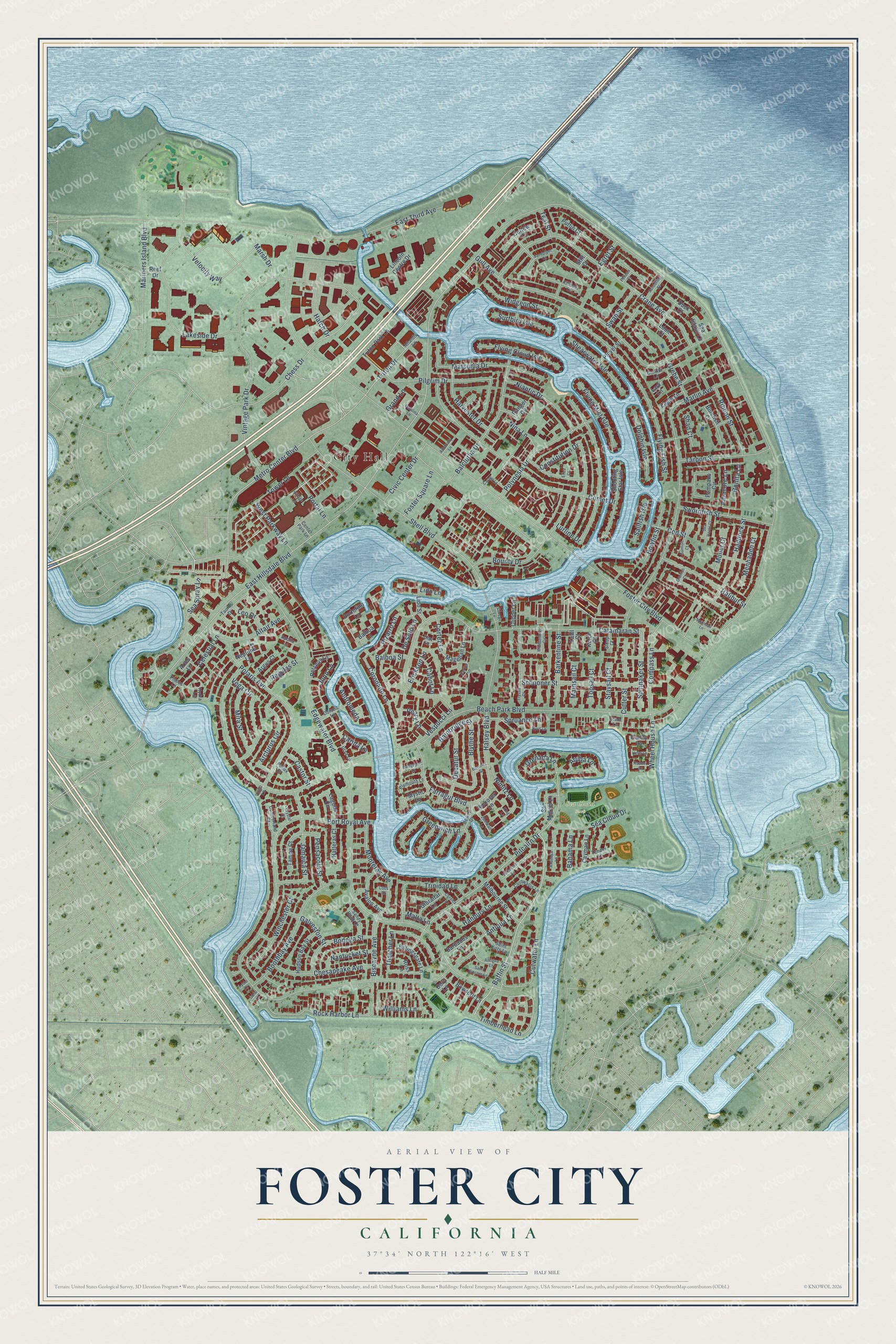
Foster City, California Map Art
Building by building, with labeled streets and shaded relief.
12" x 18" Archival Matte Print
A Map of Home. A Work of Art.
Explore Foster City, California from a whole new perspective. Created using aerial imagery and detailed geographic data, this map captures Foster City building by building, with labeled streets, familiar landmarks, and shaded topographical relief that highlights the natural contours of the landscape.
Combining modern data with the timeless character of a vintage atlas, this map is just as interesting up close as it is beautiful on the wall. Whether you grew up in Foster City, spent memorable years there, or call it home today, this unique map is a great way to celebrate a place that means something to you. Zoom in on the preview to look for your street, and then order a print to put your memories on the wall.
Three ways to hang it

Unframed archival matte, a black wood frame or a white wood frame.
Up close
Geography Worth Displaying
This map was created using accurate cartographic data and authoritative geographic sources, including the U.S. Geological Survey and the Census Bureau. The map brings together terrain, waterways, roads, and building detail. The majority of the streets are labeled, houses are accurately depicted, and the topography is derived from government sources. Combining local data with carefully composed color and shading leads to this beautifully detailed Foster City artwork for your wall.
Rather than simply showing street outlines, we’ve included as many of the street names as we could reasonably fit on the map while keeping their names legible. Zoom in on the high resolution preview to see exactly what’s on the map. We truly set out to create a statement piece for anyone who loves Foster City. So whether it’s for you, or a gift for someone you love, we hope this map of Foster City brings back fond memories.
Read the story behind this map of Foster City, California from 2026.

Find your street
Names on the Foster City map
Every name below is printed on this map. Look for your street, your school, the park where you played, or the pond down the road.
Places and landmarks3
- City Hall
- Sea Cloud Park
- Boothbay Park
Streets and roads224
- Baffin Street
- Triton Drive
- Metro Center Boulevard
- Pitcairn Drive
- Sea Spray Lane
- East Hillsdale Boulevard
- Grenada Lane
- Chess Drive
- Velocity Way
- Timberhead Lane
- Williams Lane
- Beach Park Boulevard
- Foster City Boulevard
- Edgewater Boulevard
- Port Royal Avenue
- East Third Avenue
- Shell Boulevard
- Catamaran Street
- Marlin Avenue
- Gull Avenue
- Lakeside Drive
- Vintage Park Drive
- Crane Avenue
- Comet Drive
- Mariners Island Boulevard
- Balclutha Drive
- Polaris Avenue
- Lurline Drive
- Flying Fish Street
- Cutwater Lane
Show all 224 streets
- Vespucci Lane
- Rock Harbor Lane
- Pilgrim Drive
- Boothbay Avenue
- Celestial Lane
- Constitution Drive
- Bounty Drive
- Polynesia Drive
- Thatcher Lane
- Jamaica Street
- Schooner Street
- Trinidad Lane
- Chesapeake Avenue
- Monterey Avenue
- Matsonia Drive
- Halsey Boulevard
- Vega Circle
- Blythe Street
- Compass Lane
- Swordfish Street
- Halibut Street
- Arcturus Circle
- Tarpon Street
- Farragut Boulevard
- Antiqua Lane
- Pizarro Lane
- Altair Avenue
- Nimitz Lane
- Niantic Drive
- Bodega Street
- Greenwich Lane
- Barkentine Street
- Sea Cloud Drive
- Bonita Lane
- Coronado Lane
- Harvester Drive
- Flying Cloud Isle
- Spinnaker Street
- Winchester Court
- Haddock Street
- Aruba Lane
- Ribbon Street
- Shearwater Isle
- Civic Center Drive
- Decatur Street
- Spruance Lane
- Flying Mist Isle
- Albacore Lane
- Hanbury Lane
- Pensacola Street
- De Soto Lane
- Mira Street
- Nina Lane
- Dolphin Isle
- Widgeon Street
- Juno Lane
- Biscayne Avenue
- Portal Lane
- West Parkway Lane
- Balboa Street
- Nantucket Street
- Carina Lane
- Hatch Drive
- Foster Square Lane
- Wheel House Lane
- Marsh Drive
- Surfbird Isle
- Bowfin Street
- Galveston Street
- Regulas Street
- Menhaden Court
- Bainbridge Street
- Cod Street
- Tower Lane
- Erickson Lane
- Andromeda
- Swan Street
- Grebe Street
- Castor Street
- Mullet Court
- Leo Drive
- Peary Lane
- Cabot Lane
- Sailfish Isle
- Lido Lane
- Cortez Lane
- Mainsail Court
- Topsail Court
- Staysail Court
- Bahama Lane
- Grand Lane
- Shad Court
- Teal Street
- Egret Street
- Malta Lane
- Cutter Street
- Triton Park Lane
- Magellan Lane
- Curlew Court
- Loon Court
- Pompano Circle
- Balboa Lane
- Shooting Star Isle
- Laguna Circle
- Ranger Circle
- Melbourne Street
- Lincoln Centre Drive
- Puffin Court
- Bluefish Court
- Portofino Lane
- Avalon Avenue
- Mystic Lane
- Hudson Bay Street
- Billingsgate Lane
- San Miguel Lane
- Tampa Court
- Duck Court
- Stilt Court
- Hatteras Court
- Rickover Lane
- Neptune Lane
- Perseus Lane
- Lido Street
- Barbados Lane
- Gibraltar Lane
- Plover Street
- Bowsprit Lane
- Argus Court
- Lark Lane
- Cayman Lane
- Clipper Lane
- Eagle Lane
- Sea Island Lane
- Galley Lane
- Aries Lane
- Dory Lane
- Reef Drive
- Yawl Court
- Ketch Court
- Ross Lane
- Center Park Lane
- Killdeer Court
- Taurus Drive
- Saint Kitts Lane
- Cornwallis Lane
- Dorado Lane
- Ursa Lane
- Sandy Hook Court
- Cumberland Court
- Plymouth Lane
- Apollo Lane
- Condor Lane
- Dewey Drive
- Tender Lane
- Pollux Court
- Sloop Court
- Atlantis Lane
- Diaz Lane
- Pisces Lane
- Hydra Lane
- Stern Lane
- Virgo Lane
- Caravel Lane
- Sandpiper Court
- King Lane
- Zumwalt Lane
- Antigua Lane
- Moonsail Lane
- Windjammer Circle
- Admiralty Lane
- Somerset Lane
- Anacapa Lane
- Pelican Court
- Village Lane
- Bridgeport Lane
- Grunion Court
- Trysail Court
- Sunfish Court
- Saint Vincent Lane
- Sanderling Street
- Cartier Lane
- Catalina Lane
- Corsica Lane
- Sea Horse Court
- Helm Lane
- Rudder Lane
- Corsair Lane
- Burrows Street
- Byrd Lane
- Crystal Court
- Lyme Lane
- Coral Lane
- Coos Court
- Eliza Court
Names are listed as they appear on the printed map. Zoom into the product photos to find them.
About Foster City, California
Foster City is a city of 33,805 people in San Mateo County, on the San Francisco Bay just east of San Mateo. It was built in the 1960s on Brewer Island, a stretch of bay marsh, and engineered landfill raised and widened the ground. The city takes its name from T. Jack Foster, a real estate developer who owned much of the land and helped draw up its first design.
The first residents moved in on March 7, 1964. One of them was Charles Zerbe, a San Francisco firefighter, who bought a four-bedroom house on Pilgrim Drive for his wife and two young sons for $23,500. The earliest homes sold for less than $18,000, and by the late 1960s the average price had climbed to a little under $30,000.
“Amid this beauty and prosperity, it is difficult to picture the raw, barren land of Brewer's Island with which Foster and Grant began their development.”
- A lagoon instead of fillThe central lagoon that winds through the city was a plan by Wilsey Hamm. Its channels carried water off the low ground, so the builders needed less fill to drain the site properly. The man-made lagoon system now covers 218 acres, and only electric, wind or human-powered boats are allowed on it, to protect the water and keep the noise down.
- A pier from the old bridgeWerder Pier is what remains of the first San Mateo-Hayward Bridge across the bay. It ranks among the longest and oldest piers in California and was once a popular fishing spot, but it has closed because it needs major repair.
- The story behind Over the EdgeIn 1973 the San Francisco Examiner ran an article titled "Mousepacks: Kids on a Crime Spree" about a string of crimes by teenagers in Foster City. Those events became the basis for the movie Over the Edge.
- Visa's home baseAround 1993 Visa began gathering its scattered San Mateo offices into Foster City, and the company became the city's largest employer. Its four buildings stand where Metro Center Boulevard meets Vintage Park Drive. Visa moved its top executives to San Francisco in 2009, but about 2,400 employees still worked in Foster City that year.
Keep exploring California
Foster City is one of 1,990 California towns we've mapped. Every dot on the map is a print of its own.
The search covers every state, California first.
Near Foster City
Order 2 or more town maps and save 10%. Shown in the size and finish you picked above, so they hang as a set.
- San Mateo 12" x 18" / Archival Matte Print $39.99
- Redwood City 12" x 18" / Archival Matte Print $39.99
- Belmont 12" x 18" / Archival Matte Print $39.99


More maps nearby: San Carlos, Baywood Park, Hillsborough, Highlands and Burlingame.
The art of mapping a place
How This Map Was Made
Real places. Remarkable detail. Discover the layers that turn geographic data into a map of home.

The view from above
Aerial imagery reveals the character of the land: woodland, open fields, and the patterns of a place.

The shape of the land
Elevation data brings hills, valleys, and subtle changes in the landscape into view.

The details of home
Roads, waterways, and building footprints come together to make the map feel unmistakably local.

Geography becomes art
Considered color, shading, and typography bring the layers together in a map made for your wall.


Process illustrated with Mendon, Massachusetts. Aerial imagery: USDA NAIP. Terrain: USGS 3D Elevation Program. Map details and finished artwork: KNOWOL.
The Details
About This Print
Choose an archival matte print, or a black or white Ayous wood frame. The archival matte print is unframed.
Select your size and finish above to see the matching product image and price.
Materials & Craftsmanship
A contemporary map with the character of a classic atlas, printed on archival matte paper. Optional frames are made from Ayous wood.
Your printed map does not include the watermark shown in the full-map preview.
Shipping & Delivery
Free shipping within the United States. Every print is made to order in the USA.
Buying a gift? Add a note in your cart and we'll include it. We never put prices in the package.
Prints ship within 2 to 3 business days. Allow 7 to 10 days total from ordering for delivery. Timing may vary during holidays or periods of high order volume.
Read our shipping policy.
Returns and damaged prints
Each print is made to order. Change-of-mind refunds are not available after production.
If your print arrives damaged, misprinted or incorrect, contact support@knowol.com within 30 days of receiving it. Include your order number, photos and a description of the issue.
Read our full refund and replacement policy. For questions about your order, email support@knowol.com.