


Search for another town


Free U.S. delivery 7 to 10 days after you order
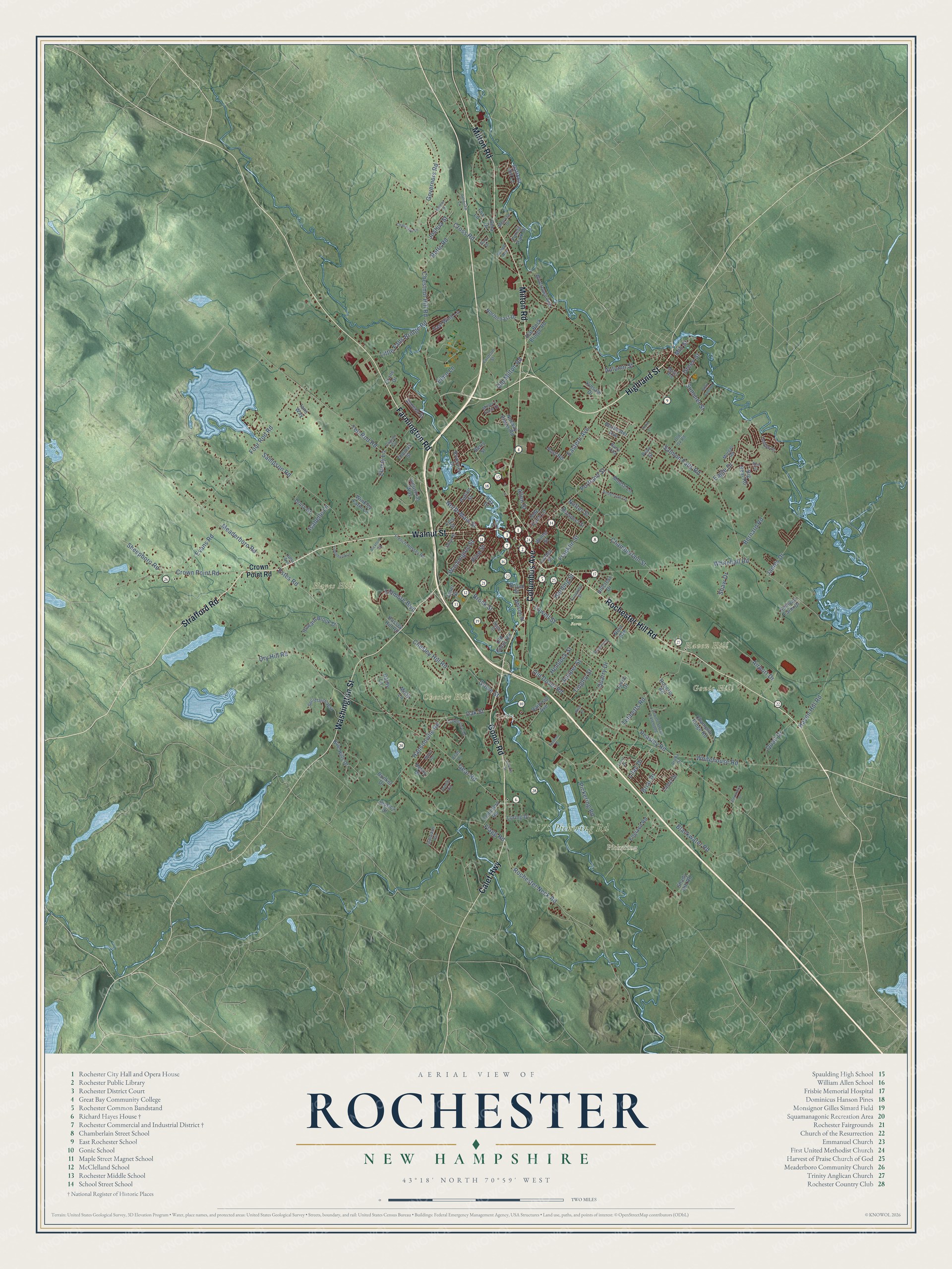
Rochester, New Hampshire Map Art
Building by building, with labeled streets and shaded relief.
12" x 18" Archival Matte Print
A Map of Home. A Work of Art.
Explore Rochester, New Hampshire from a whole new perspective. Created using aerial imagery and detailed geographic data, this map captures Rochester building by building, with labeled streets, familiar landmarks, and shaded topographical relief that highlights the natural contours of the landscape.
Combining modern data with the timeless character of a vintage atlas, this map is just as interesting up close as it is beautiful on the wall. Whether you grew up in Rochester, spent memorable years there, or call it home today, this unique map is a great way to celebrate a place that means something to you. Zoom in on the preview to look for your street, and then order a print to put your memories on the wall.
Three ways to hang it

Unframed archival matte, a black wood frame or a white wood frame.
Up close
Geography Worth Displaying
This map was created using accurate cartographic data and authoritative geographic sources, including the U.S. Geological Survey (USGS) and FEMA. The map brings together terrain, waterways, roads, and building detail. The majority of the streets are labeled, houses are accurately depicted, and the topography is derived from government sources. Combining local data with carefully composed color and shading leads to this beautifully detailed Rochester artwork for your wall.
Rather than simply showing street outlines, we’ve included as many of the street names as we could reasonably fit on the map while keeping their names legible. Zoom in on the high resolution preview to see exactly what’s on the map. We truly set out to create a statement piece for anyone who loves Rochester. So whether it’s for you, or a gift for someone you love, we hope this map of Rochester brings back fond memories.
Explore the full map of Rochester, New Hampshire and read about the local places it shows.

Find your street
Names on the Rochester map
Every name below is printed on this map. Look for your street, your school, the park where you played, or the pond down the road.
Places and landmarks8
- Pickering
- Chesley Hill
- Gonic Hill
- Haven Hill
- Hayes Hill
- 175 Pickering Rd
- Tree Farm
- Gonic
Streets and roads168
- Walnut Street
- Highland Street
- Columbus Avenue
- Gonic Road
- Strafford Road
- Calef Highway
- Milton Road
- Rochester Hill Road
- Washington Street
- Farmington Road
- North Main Street
- Rochester Neck Road
- Estes Road
- Gear Road
- Lowell Street
- Oak Street
- Chestnut Hill Road
- Portland Street
- Chesley Hill Road
- Salmon Falls Road
- Old Dover Road
- Pickering Road
- Ten Rod Road
- Whitehall Road
- Blackwater Road
- Tebbetts Road
- Dry Hill Road
- Cross Road
- Four Rod Road
- Betts Road
Show all 168 streets
- Meaderboro Road
- Sampson Road
- Crown Point Road
- Flagg Road
- Eastern Avenue
- Franklin Street
- Eagle Drive
- Hansonville Road
- Chamberlain Street
- Whitehouse Road
- Haven Hill Road
- Brock Street
- Summer Street
- Grove Street
- Jamey Drive
- Airport Drive
- Little Falls Bridge Road
- Governors Road
- Autumn Street
- Harding Street
- Evans Road
- Hemlock Street
- Sheepboro Road
- Quail Drive
- Peasley Road
- Fillmore Boulevard
- Bernard Road
- Briar Drive
- Lilac Drive
- Pine Street
- Quarry Drive
- Old Milton Road
- Shaw Drive
- Tingley Street
- Juniper Street
- Ebony Lane
- Allen Street
- Joshua Street
- Isabelle Lane
- Nutter Street
- Elmo Lane
- Green Street
- Mill Street
- Lanai Drive
- Henry Drive
- Winkley Farm Lane
- England Road
- Blue Hills Drive
- Daffodil Hill Lane
- Forest Park Drive
- Flat Rock Bridge Road
- Industrial Way
- Champlin Ridge Road
- Darby Lane
- Riverview Drive
- Winter Street
- Northcoast Drive
- Howard Brook Drive
- Norway Plains Road
- Railroad Avenue
- Patton Street
- Big Bear Road
- Gina Drive
- East Wind Lane
- Jessica Drive
- Riverlawn Avenue
- Pray Street
- Seneca Street
- Moose Lane
- Sullivan Farm Drive
- Rochester Avenue
- Prospect Street
- Drury Drive
- Loring Drive
- Roberts Road
- Shady Hill Road
- Cemetery Road
- Hillcrest Drive
- Lois Street
- Nola Avenue
- Misty Lane
- Wilson Street
- Kinsale Drive
- Thomas Street
- Old Gonic Road
- Olde Farm Lane
- Post Road
- Ians Way
- Linden Street
- Bunker Drive
- Hussey Hill Road
- Janet Street
- Laura Drive
- Crane Drive
- Broad Street
- Berry Street
- Fox Lane
- Ray Drive
- Stillwater Circle
- Ledgeview Drive
- Lowell Street Extended
- Temple Drive
- Trinity Circle
- Miller's Farm Drive
- Secretariat Way
- Capitol Circle
- Fordcon Street
- French Hussey Road
- Aruba Drive
- Anderson Lane
- Crockett Street
- Old Ox Road
- Magic Avenue
- Melrose Drive
- State Street
- Snow Street
- Sewell Avenue
- Morgan Road
- Efab Lane
- Barry Villa
- Julia Avenue
- Gary Drive
- Thorn Drive
- Royalcrest
- Church Street
- Blair Drive
- Mavis Avenue
- Channings Lane
- Fiddlehead Lane
- Stair Falls Road
- Pondview Lane
- Alexandra Lane
- Bickford Road
- Nadeau Drive
- Alice Lane
- Kelmar Street
- Katie Lane
- Cove Court
Names are listed as they appear on the printed map. Zoom into the product photos to find them.
About Rochester, New Hampshire
Rochester is a city of 32,492 people in Strafford County, on the Maine line. Governor Samuel Shute granted it as one of four new towns, with Barrington, Nottingham and Chester, and it was incorporated in 1722 under a name honoring his friend Laurence Hyde, 1st Earl of Rochester, who was King James II's brother-in-law. Settlement began in the first year of Lovewell's War, and although no battles were fought here, lone settlers were ambushed until residents formed a militia under Abraham Benwick.
Lumbering came first, but the Cochecho River turned Rochester into a mill town. By 1806 it ran six tanneries, a sawmill, a fulling mill and two gristmills. Woolen blankets from the Mechanics Company, founded in 1834, took the premium award at the 1853 World's Fair in New York. In 1870 the Norway Plains Woolen Company wove 1,600,000 yards of cloth. Shoes had overtaken textiles by 1880, and Rochester became a city in 1891.
- Parson Main and Norway PlainThe Reverend Amos Main became the Congregational church's first settled pastor in 1737, and his statue by Giuseppe Moretti now looks over the square. The common, once 250 acres and named Norway Plain for its pines, was where soldiers met before leaving for the Revolution. Its Civil War monument lists the 54 men who died. Its four cannons were melted down in World War II and replaced with guns from that war.
- A floor that tiltsGeorge G. Adams designed the City Hall and Opera House, which opened on Memorial Day 1908. Its floor could be inclined for plays and concerts or laid flat for dances and meetings. Fires destroyed most of Adams' other buildings, so Rochester's is the only known theater in the country still using such a floor. Volunteers spent ten thousand hours restoring it, and it reopened in 1997.
- A Carnegie library in 1905In the early 1900s Postmaster Osman Warren sent a letter to Andrew Carnegie, and the Carnegie Institute gave $20,000 to build a library on the site of the old Main Street School. Built of brick and granite with golden oak and cypress inside, it opened on October 2, 1905, when 150 people registered. Lillian Parshley served as its first librarian until she died in 1945.
- A shoe townIn 1930 Samuel J. Katz of Brookline started the Hubbard Shoe Company, which at its peak employed about four hundred people who made men's shoes in East Rochester and five hundred who made women's shoes in Rochester. Hubbard and the Maybury Shoe Company made it through the Great Depression and World War Two, but cheap foreign imports beat them in the 1970s.
- The Richard Hayes House, 1787Richard Hayes of Madbury built his house on Gonic Road in 1787, on 80 acres given to him by his father, Daniel. Its two wings join at a right angle, an unusual plan for a Federal house. The Hayes family owned it until 1881, and it joined the National Register in 1986.
Keep exploring New Hampshire
Rochester is one of 279 New Hampshire towns we've mapped. Every dot on the map is a print of its own.
The search covers every state, New Hampshire first.
Near Rochester
Order 2 or more town maps and save 10%. Shown in the size and finish you picked above, so they hang as a set.
- Somersworth 12" x 18" / Archival Matte Print $39.99
- Farmington 12" x 18" / Archival Matte Print $39.99
- Barrington 12" x 18" / Archival Matte Print $39.99


More maps nearby: Milton, Rollinsford, Madbury, Dover and Strafford.
The art of mapping a place
How This Map Was Made
Real places. Remarkable detail. Discover the layers that turn geographic data into a map of home.

The view from above
Aerial imagery reveals the character of the land: woodland, open fields, and the patterns of a place.

The shape of the land
Elevation data brings hills, valleys, and subtle changes in the landscape into view.

The details of home
Roads, waterways, and building footprints come together to make the map feel unmistakably local.

Geography becomes art
Considered color, shading, and typography bring the layers together in a map made for your wall.


Process illustrated with Mendon, Massachusetts. Aerial imagery: USDA NAIP. Terrain: USGS 3D Elevation Program. Map details and finished artwork: KNOWOL.
The Details
About This Print
Choose an archival matte print, or a black or white Ayous wood frame. The archival matte print is unframed.
Select your size and finish above to see the matching product image and price.
Materials & Craftsmanship
A contemporary map with the character of a classic atlas, printed on archival matte paper. Optional frames are made from Ayous wood.
Your printed map does not include the watermark shown in the full-map preview.
Shipping & Delivery
Free shipping within the United States. Every print is made to order in the USA.
Buying a gift? Add a note in your cart and we'll include it. We never put prices in the package.
Prints ship within 2 to 3 business days. Allow 7 to 10 days total from ordering for delivery. Timing may vary during holidays or periods of high order volume.
Read our shipping policy.
Returns and damaged prints
Each print is made to order. Change-of-mind refunds are not available after production.
If your print arrives damaged, misprinted or incorrect, contact support@knowol.com within 30 days of receiving it. Include your order number, photos and a description of the issue.
Read our full refund and replacement policy. For questions about your order, email support@knowol.com.