
Search for another town


Free U.S. delivery 7 to 10 days after you order
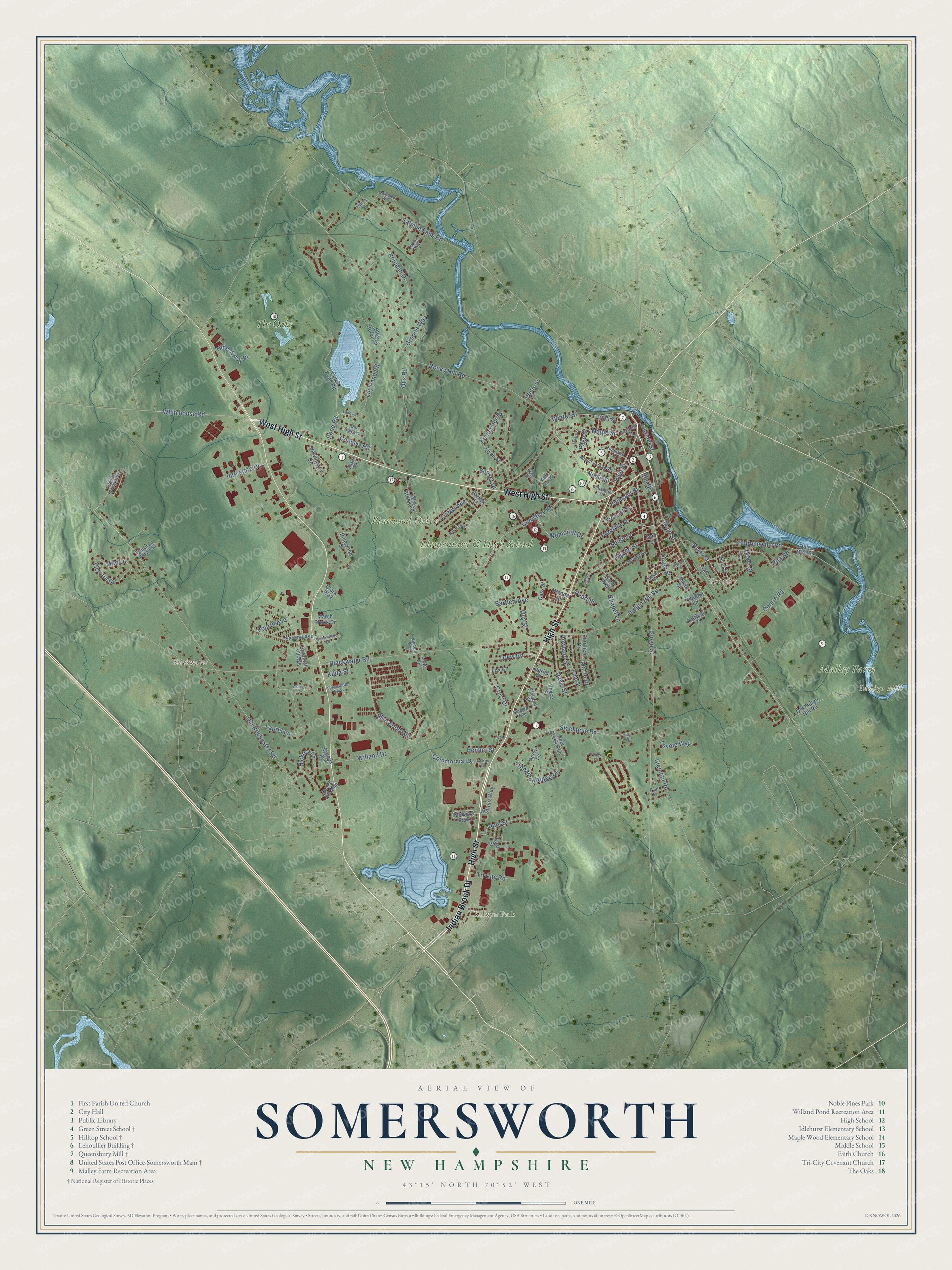
Somersworth, New Hampshire Map Art
Building by building, with labeled streets and shaded relief.
12" x 18" Archival Matte Print
A Map of Home. A Work of Art.
Explore Somersworth, New Hampshire from a whole new perspective. Created using aerial imagery and detailed geographic data, this map captures Somersworth building by building, with labeled streets, familiar landmarks, and shaded topographical relief that highlights the natural contours of the landscape.
Combining modern data with the timeless character of a vintage atlas, this map is just as interesting up close as it is beautiful on the wall. Whether you grew up in Somersworth, spent memorable years there, or call it home today, this unique map is a great way to celebrate a place that means something to you. Zoom in on the preview to look for your street, and then order a print to put your memories on the wall.
Three ways to hang it

Unframed archival matte, a black wood frame or a white wood frame.
Up close
Geography Worth Displaying
This map was created using accurate cartographic data and authoritative geographic sources, including the U.S. Geological Survey (USGS) and FEMA. The map brings together terrain, waterways, roads, and building detail. The majority of the streets are labeled, houses are accurately depicted, and the topography is derived from government sources. Combining local data with carefully composed color and shading leads to this beautifully detailed Somersworth artwork for your wall.
Rather than simply showing street outlines, we’ve included as many of the street names as we could reasonably fit on the map while keeping their names legible. Zoom in on the high resolution preview to see exactly what’s on the map. We truly set out to create a statement piece for anyone who loves Somersworth. So whether it’s for you, or a gift for someone you love, we hope this map of Somersworth brings back fond memories.
Explore the full map of Somersworth, New Hampshire and read about the local places it shows.

Find your street
Names on the Somersworth map
Every name below is printed on this map. Look for your street, your school, the park where you played, or the pond down the road.
Places and landmarks9
- Foundry
- Indigo Hill
- Malley Farm
- Elementary & High School
- Pinewood Drive
- Blackwater
- Kelwyn Park
- The Oaks
- Midway Park
Streets and roads132
- High Street
- West High Street
- Indian Brook Drive
- Main Street
- Winter Street
- Fourth Avenue
- Pond Road
- Sherwood Gln
- River Street
- Green Street
- Maple Street
- Cinnamon Ridge Road
- Myrtle Street
- Blackwater Road
- Rocky Hill Road
- Old Rochester Road
- Indigo Hill Road
- Salmon Falls Road
- Buffumsville Road
- Stackpole Road
- Lily Pond Road
- Laurel Lane
- Willand Drive
- Cemetery Road
- Otis Road
- Rouleau Drive
- Whitehouse Road
- Centre Road
- Crest Drive
- Union Street
Show all 132 streets
- Franklin Street
- Noble Street
- Commercial Drive
- Davis Street
- Francoeur Drive
- Hickory Lane
- Bartlett Avenue
- Memorial Drive
- Maize Drive
- South Street
- Milo Lane
- Lil Nor Avenue
- Victoria Drive
- Clement Road
- Tri City Road
- Interstate Drive
- Lavoie Way
- Sunset Drive
- Hide-Away Place
- Ruel Street
- Drew Road
- Granite Way
- Coombs Road
- Page Street
- Canal Street
- Guy Street
- Rowland Street
- Pleasant Street
- Bernier Street
- Down Street
- Chapel Lane
- Rita Road
- Kilda Street
- Pearl Street
- Elm Street
- Wells Street
- Colonial Village
- Tates Brook Road
- Coles Pond Road
- Hawthorne Circle
- Acorn Lane
- Blue Heron Drive
- Nash Parkway
- Laurier Street
- Old Indigo Hill Road
- Waltons Way
- Deer Creek Run
- Second Avenue
- Flynn Street
- Olde Mill Road
- Fremont Street
- Verona Street
- Marsh Brook Drive
- Cornfield Drive
- Joyce Street
- Brenda Avenue
- Cote Street
- Third Street
- Ellswick Street
- Turgeon Lane
- East Street
- Varney Street
- Cass Street
- Patricia Street
- Clark Way
- Jack & Jill Mhp
- Cliff Street
- Lilac Lane
- Fox Court
- Alicia Street
- Ford Street
- Hamilton Street
- Highland Street
- Crystal Springs Way
- Prospect Street
- Mount Vernon Street
- Unnamed Private Drive
- Morning Street
- Oak Ridge Drive
- Cameron Way
- First Street
- Ron Wyn Drive
- Greenfield Drive
- Terrascape Parkway
- Curran Way
- Sinclair Avenue
- Spruce Street
- Penny Lane
- Paul Street
- Vincent Way
- Squire Drive
- Baker Way
- Brian Street
- Emery Street
- Ben Rich Drive
- Hanson Street
- Lakeview Drive
- Walnut Street
- Adams Court
- Firefly Circle
- Molly Lane
- Apple Lane
Names are listed as they appear on the printed map. Zoom into the product photos to find them.
About Somersworth, New Hampshire
Somersworth is a city of 11,855 people in Strafford County, where the Salmon Falls River forms the border with Maine. The Abenaki called the river Newichwanook. English colonists named the area Sligo, after the Irish town, and settled it as part of Dover. In 1729 it became the parish of Summersworth, the "summer town," because ministers preached there in that season. Governor Benning Wentworth incorporated it in 1754, and a clerk's slip trimmed the name to Somersworth. Rollinsford belonged to the town until 1849, and the place was also known as Great Falls until it became a city in 1893.
The river drops 100 feet in a mile here, and its power first ran gristmills and sawmills. In 1822 two Boston brothers, Isaac and Jacob Wendell, bought a gristmill and its water rights at the falls for $5,000 and founded the Great Falls Manufacturing Company. It grew to three mills making cotton and woolen cloth, and a bleachery later turned the buff cloth from the city's seven mills white, ready to dye or print. The 1922 New England Textile Strike shut the mills over an attempted wage cut, and the industry declined after that. In the 1980s the big Great Falls mill found other uses.
- A mill tenement from about 1843Thomas Parks and Job Harris built the Lehoullier Building around 1843 at 161 to 169 Main Street, on land the mill company granted them. The brick tenement holds three townhouse units, three stories tall facing the street and two in back. Many such rows once lined Main Street, and it is one of only two left. It joined the National Register in 1979.
- A hilltop school from 1890Work began in 1890 on the Green Street School, a brick and granite building on a hill south of downtown, serving a neighborhood of mostly French-Canadian immigrants. Its steep hip roof and Queen Anne cornice make it look bigger than it is. It taught public school pupils until 1927 and parochial high school students from 1934 until about 1970. Conversion into homes began in 1983, and it joined the National Register in 1985.
- Trolleys to York BeachOff the job, mill hands headed for the Opera House or for Central Park, the amusement park on Willand Pond. The Portsmouth, Great Falls & Conway Railroad began running excursions to the White Mountains in the early 1870s, and from 1890 the Electric Street Railway carried riders by trolley to York Beach, Maine.
- The USS SomersworthThe patrol craft USS Somersworth was commissioned in April 1944 and was in Tokyo Bay for the surrender of Japan at the end of World War II. The Navy gave it the city's name in February 1956, and it served until September 1965. USS Somersworth Park stands at Main and Market streets.
Keep exploring New Hampshire
Somersworth is one of 279 New Hampshire towns we've mapped. Every dot on the map is a print of its own.
The search covers every state, New Hampshire first.
Near Somersworth
Order 2 or more town maps and save 10%. Shown in the size and finish you picked above, so they hang as a set.
- Rollinsford 12" x 18" / Archival Matte Print $39.99
- Dover 12" x 18" / Archival Matte Print $39.99
- Rochester 12" x 18" / Archival Matte Print $39.99


More maps nearby: Madbury, Barrington, Durham, Lee and Farmington.
The art of mapping a place
How This Map Was Made
Real places. Remarkable detail. Discover the layers that turn geographic data into a map of home.

The view from above
Aerial imagery reveals the character of the land: woodland, open fields, and the patterns of a place.

The shape of the land
Elevation data brings hills, valleys, and subtle changes in the landscape into view.

The details of home
Roads, waterways, and building footprints come together to make the map feel unmistakably local.

Geography becomes art
Considered color, shading, and typography bring the layers together in a map made for your wall.


Process illustrated with Mendon, Massachusetts. Aerial imagery: USDA NAIP. Terrain: USGS 3D Elevation Program. Map details and finished artwork: KNOWOL.
The Details
About This Print
Choose an archival matte print, or a black or white Ayous wood frame. The archival matte print is unframed.
Select your size and finish above to see the matching product image and price.
Materials & Craftsmanship
A contemporary map with the character of a classic atlas, printed on archival matte paper. Optional frames are made from Ayous wood.
Your printed map does not include the watermark shown in the full-map preview.
Shipping & Delivery
Free shipping within the United States. Every print is made to order in the USA.
Buying a gift? Add a note in your cart and we'll include it. We never put prices in the package.
Prints ship within 2 to 3 business days. Allow 7 to 10 days total from ordering for delivery. Timing may vary during holidays or periods of high order volume.
Read our shipping policy.
Returns and damaged prints
Each print is made to order. Change-of-mind refunds are not available after production.
If your print arrives damaged, misprinted or incorrect, contact support@knowol.com within 30 days of receiving it. Include your order number, photos and a description of the issue.
Read our full refund and replacement policy. For questions about your order, email support@knowol.com.