
Search for another town


Free U.S. delivery 7 to 10 days after you order
Rockville, Maryland Map Art
Building by building, with labeled streets and shaded relief.
12" x 18" Archival Matte Print
A Map of Home. A Work of Art.
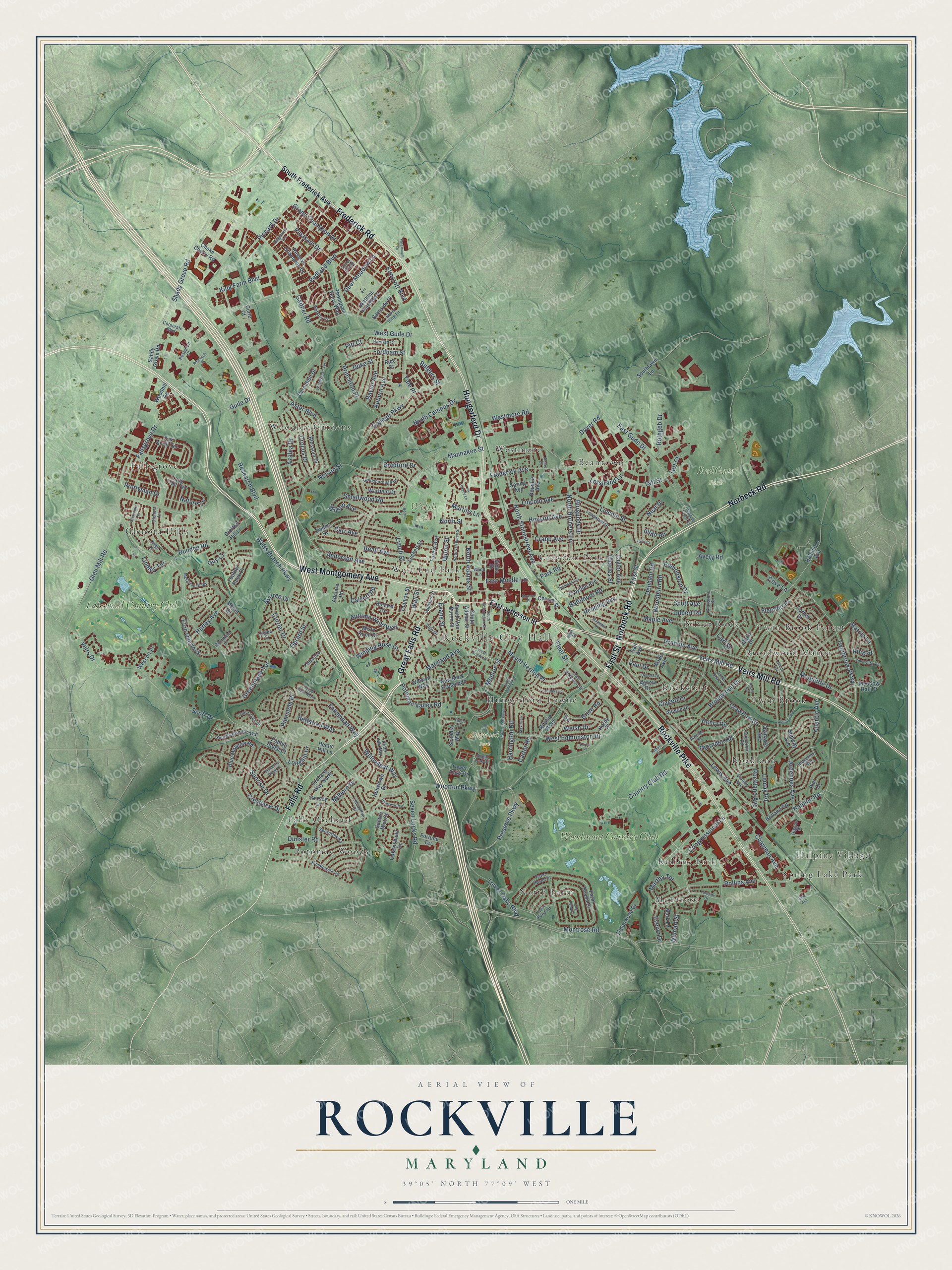
Explore Rockville, Maryland from a whole new perspective. Created using aerial imagery and detailed geographic data, this map captures Rockville building by building, with labeled streets, familiar landmarks, and shaded topographical relief that highlights the natural contours of the landscape.
Combining modern data with the timeless character of a vintage atlas, this map is just as interesting up close as it is beautiful on the wall. Whether you grew up in Rockville, spent memorable years there, or call it home today, this unique map is a great way to celebrate a place that means something to you. Zoom in on the preview to look for your street, and then order a print to put your memories on the wall.
Three ways to hang it

Unframed archival matte, a black wood frame or a white wood frame.
Up close
Geography Worth Displaying
This map was created using accurate cartographic data and authoritative geographic sources, including the U.S. Geological Survey and the Census Bureau. The map brings together terrain, waterways, roads, and building detail. The majority of the streets are labeled, houses are accurately depicted, and the topography is derived from government sources. Combining local data with carefully composed color and shading leads to this beautifully detailed Rockville artwork for your wall.
Rather than simply showing street outlines, we’ve included as many of the street names as we could reasonably fit on the map while keeping their names legible. Zoom in on the high resolution preview to see exactly what’s on the map. We truly set out to create a statement piece for anyone who loves Rockville. So whether it’s for you, or a gift for someone you love, we hope this map of Rockville brings back fond memories.
Read the story behind this map of Rockville, Maryland from 2026.

Find your street
Names on the Rockville map
Every name below is printed on this map. Look for your street, your school, the park where you played, or the pond down the road.
Places and landmarks27
- Rockville City Hall
- Halpine Village
- Dogwood Park
- RedGate Park
- Welsh Park
- Beantown
- Broadwood Manor
- Croydon Park
- Falls Orchard
- Fallsgrove
- Glenora Hills
- Hungerford Towne
Show all 27 places
- Montrose
- North Farm
- Potomac Woods
- Rockcrest
- Rockland
- Rollins Park
- Silver Rock
- Spring Lake Park
- Twin Brook
- Twin Brook Forest
- West End Park
- Westmore
- Woodley Gardens
- Lakewood Country Club
- Woodmont Country Club
Streets and roads283
- West Montgomery Avenue
- Norbeck Road
- Falls Road
- Great Falls Road
- First Street
- Frederick Road
- Veirs Mill Road
- Hungerford Drive
- Rockville Pike
- Wootton Parkway
- Redland Boulevard
- Park Road
- Potomac Valley Road
- East Middle Lane
- Grandin Avenue
- North Horners Lane
- Edmonston Drive
- Twinbrook Parkway
- Grand Champion Drive
- Veirs Drive
- Gerard Street
- King Farm Boulevard
- Shady Grove Road
- Baltimore Road
- Broadwood Drive
- West Gude Drive
- Piccard Drive
- Lewis Avenue
- Watts Branch Parkway
- Nelson Street
Show all 283 streets
- Research Boulevard
- Crawford Drive
- Tower Oaks Boulevard
- Mannakee Street
- Beall Avenue
- Preserve Parkway
- Maryland Avenue
- Gaither Road
- Avery Road
- Monroe Street
- Montrose Road
- Seven Locks Road
- Ardennes Avenue
- College Parkway
- Glen Mill Road
- West Edmonston Drive
- North Campus Drive
- Elmcroft Boulevard
- Rollins Avenue
- North Stonestreet Avenue
- Hurley Avenue
- Fallsmead Way
- Halpine Road
- East Gude Drive
- Winding Rose Drive
- Maple Avenue
- Pleasant Drive
- Crabb Avenue
- Anderson Avenue
- Lincoln Street
- Clagett Drive
- Fallsgrove Drive
- Mount Vernon Place
- McAuliffe Drive
- Autumn Wind Way
- Country Club Road
- Fleet Street
- Aster Boulevard
- Princeton Place
- Pipestem Place
- Azalea Drive
- Dundee Road
- Woodburn Road
- Brice Road
- Sunrise Drive
- Carr Avenue
- Congressional Lane
- Willowleaf Way
- Frederick Avenue
- Chapman Avenue
- Rockland Avenue
- Henry Road
- Smallwood Road
- Lemay Road
- Crocus Drive
- Greenplace Terrace
- Harrington Road
- Martins Lane
- Scott Drive
- Prettyman Drive
- Auburn Avenue
- Atlantic Avenue
- Dover Road
- Thornden Road
- Bettstrail Way
- Lofstrand Lane
- Crestview Drive
- Gilbert Road
- Lynch Street
- Deer Meadow Lane
- Reading Avenue
- Denham Road
- Fordham Street
- Lincoln Avenue
- Westmore Road
- Currier Drive
- Eton Overlook
- Charles Street
- Milboro Drive
- Martha Terrace
- Longhill Drive
- Welsh Drive
- Taft Street
- Yale Place
- Rothgeb Drive
- Howard Avenue
- Marcia Lane
- Gude Drive
- Wilson Avenue
- Neal Drive
- North Adams Street
- Cove Lane
- Fletcher Place
- Baylor Avenue
- Scott Avenue
- Carter Road
- Evans Street
- Rutgers Street
- Dunster Road
- Evelyn Drive
- Upton Street
- Wilmart Street
- Nature Lane
- Bradford Drive
- Burgundy Drive
- Lindley Terrace
- Aintree Drive
- Taft Court
- Duke Street
- Wall Street
- Taylor Avenue
- Calvert Road
- North Street
- Paul Drive
- Allan Road
- Carl Street
- Guy Court
- Ring Street
- Pitt Court
- East Jefferson Street
- South Frederick Avenue
- Farm Haven Drive
- Ritchie Parkway
- Southlawn Lane
- New Mark Esplanade
- Oak Knoll Terrace
- Reserve Champion Drive
- Watkins Pond Boulevard
- Bullard Circle
- Orchard Way North
- Kersey Lane
- Blossom Drive
- Thompson Dairy Way
- Long Trail Terrace
- Meadow Hall Drive
- Blue Meadow Road
- Oakenshield Drive
- Carnation Drive
- Henslowe Drive
- Owens Street
- Allison Drive
- Midway Avenue
- Wade Avenue
- Forest Avenue
- South Adams Street
- Okinawa Avenue
- Dean Drive
- Croydon Avenue
- South Van Buren Street
- Warfield Drive
- Feather Rock Drive
- Choke Cherry Road
- Tildenwood Drive
- Crofton Hill Lane
- Sahdy Grove Road
- Welwyn Way
- Forbes Street
- Douglas Avenue
- Holland Road
- Curie Court
- Mark Lane
- Misty Knoll Drive
- Adclare Road
- Church Street
- Scandia Way
- Agnew Drive
- Barnside Place
- Hardy Place
- Thomas Street
- Pier Drive
- Baltimore Avenue
- Hectic Hill Lane
- Fortune Terrace
- Gail Avenue
- Luckett Street
- Monet Drive
- Wescott Place
- Tower Oaks Drive
- Woodhill Road
- Spring Avenue
- Pebble Ridge Court
- Scotch Mist Court
- Gibbs Street
- Rice Court
- Ridgeway Avenue
- Goldsborough Drive
- Gladstone Drive
- Stanley Avenue
- Kimblewick Road
- Parrish Drive
- Glenora Lane
- Watkins Circle
- South Fallsmead Way
- Farm Haven Court
- Gainsboro Road
- Regal Oak Drive
- Longwood Drive
- McCormick Road
- Dale Drive
- Lancashire Drive
- Coral Sea Drive
- Cliffe Hill Way
- Research Court
- Silver King Lane
- Old Creek Court
- Selworthy Road
- Corporate Boulevard
- Harvard Court
- Fallswood Drive
- Williams Street
- Farm Pond Lane
- Defoe Street
- Ritchfield Court
- Higgins Place
- Wood Lane
- Silver Glade
- New Street
- South Washington Street
- West Argyle Street
- Lorraine Drive
- Glenmore Terrace
- Cabin John Parkway
- Halesworth Drive
- North Van Buren Street
- Ridgemont Avenue
- Ivy League Lane
- Pinneberg Avenue
- Aleutian Avenue
- Crothers Lane
- Redgate Farms Court
- Nimitz Avenue
- Lily Pond Court
- Wintergreen Terrace
- Mapleton Road
- West Lynfield Drive
- Moore Drive
- Infield Court North
- Highland Avenue
- Debeck Drive
- Burris Road
- Talbott Street
- Curtis Place
- Paramount Drive
- Farsta Court
- Maxim Lane
- Blueberry Ridge Court
- Lodge Place
- Monroe Place
- Research Place
- Hull Place
- Lynn Court
- Norris Street
- Bou Avenue
Names are listed as they appear on the printed map. Zoom into the product photos to find them.
About Rockville, Maryland
Rockville is a city of 67,117 people and the county seat of Montgomery County. On September 6, 1776, the Maryland Constitutional Convention split Frederick County into three parts, and the southern part became Montgomery County. George Town was the new county's biggest town, but it sat at the far southern edge. So the seat went to a small, central village known as Hungerford's Tavern. The tavern served as the courthouse and held its first session on May 20, 1777, and people began calling the place Montgomery Court House.
In 1784 landowner William Prather Williams paid a surveyor to plan out most of the town, and some called it Williamsburg in his honor. A plan to name it Wattsville, for nearby Watts Branch, fell through because the stream seemed too small. On July 16, 1803, the county land records entered the name Rockville, taken from Rock Creek, though Montgomery Court House stayed on maps through the 1820s. After a petition from its citizens, the Maryland General Assembly incorporated the town on March 10, 1860.
“we marched to larance Owings or Owings Oardianary, a Single House, it being 18 miles and very dirty.”
- Owen's Ordinary in 1755Lawrence Owen kept a small inn on the Rock Creek Main Road, which began as Sinequa Trail, an Indigenous path along the high ground. Major General Edward Braddock and his army halted at the inn on April 14, 1755. He was setting out from George Town to press British claims to the western frontier, and this visit is the first recorded mention of the settlement.
- Generals on both sidesIn 1862 the Union general George B. McClellan made the Beall-Dawson House his lodging. On June 28, 1863, J.E.B. Stuart and 8,000 Confederate cavalrymen occupied Rockville on their way to Gettysburg. Jubal Early passed through in 1864, going to and from his attack on Washington. The Beall-Dawson House joined the National Register in 1973.
- Rails since 1873The Baltimore and Ohio Railroad brought its Metropolitan Branch to Rockville in 1873, linking the town to Washington, D.C. The Rockville Railroad Station joined the National Register in 1974. Trolleys ran to Washington from July 1891 until cars replaced them in August 1935, and the Rockville Metro station opened on July 25, 1984.
- The Fitzgeralds at St. Mary'sIn 1975 the caskets of F. Scott and Zelda Fitzgerald were moved to St. Mary's Catholic Church in Rockville. His father, Edward, and several members of the Key family were already buried there. Old St. Mary's Church and Cemetery joined the National Register in 1978.
- A song by R.E.M.Mike Mills of R.E.M. wrote "(Don't Go Back To) Rockville" because he didn't want his girlfriend, Ingrid Schorr, to move back home to Rockville. The band released it in 1984.
Keep exploring Maryland
Rockville is one of 881 Maryland towns we've mapped. Every dot on the map is a print of its own.
The search covers every state, Maryland first.
Near Rockville
Order 2 or more town maps and save 10%. Shown in the size and finish you picked above, so they hang as a set.
- Derwood 12" x 18" / Archival Matte Print $39.99
- Rosemont 12" x 18" / Archival Matte Print $39.99
- Redland 12" x 18" / Archival Matte Print $39.99


More maps nearby: North Bethesda, Aspen Hill, Washington Grove, North Potomac and Garrett Park.
The art of mapping a place
How This Map Was Made
Real places. Remarkable detail. Discover the layers that turn geographic data into a map of home.

The view from above
Aerial imagery reveals the character of the land: woodland, open fields, and the patterns of a place.

The shape of the land
Elevation data brings hills, valleys, and subtle changes in the landscape into view.

The details of home
Roads, waterways, and building footprints come together to make the map feel unmistakably local.

Geography becomes art
Considered color, shading, and typography bring the layers together in a map made for your wall.


Process illustrated with Mendon, Massachusetts. Aerial imagery: USDA NAIP. Terrain: USGS 3D Elevation Program. Map details and finished artwork: KNOWOL.
The Details
About This Print
Choose an archival matte print, or a black or white Ayous wood frame. The archival matte print is unframed.
Select your size and finish above to see the matching product image and price.
Materials & Craftsmanship
A contemporary map with the character of a classic atlas, printed on archival matte paper. Optional frames are made from Ayous wood.
Your printed map does not include the watermark shown in the full-map preview.
Shipping & Delivery
Free shipping within the United States. Every print is made to order in the USA.
Buying a gift? Add a note in your cart and we'll include it. We never put prices in the package.
Prints ship within 2 to 3 business days. Allow 7 to 10 days total from ordering for delivery. Timing may vary during holidays or periods of high order volume.
Read our shipping policy.
Returns and damaged prints
Each print is made to order. Change-of-mind refunds are not available after production.
If your print arrives damaged, misprinted or incorrect, contact support@knowol.com within 30 days of receiving it. Include your order number, photos and a description of the issue.
Read our full refund and replacement policy. For questions about your order, email support@knowol.com.