
Search for another town


Free U.S. delivery 7 to 10 days after you order
Seven Lakes, North Carolina Map Art
Building by building, with labeled streets and shaded relief.
12" x 18" Archival Matte Print
A Map of Home. A Work of Art.
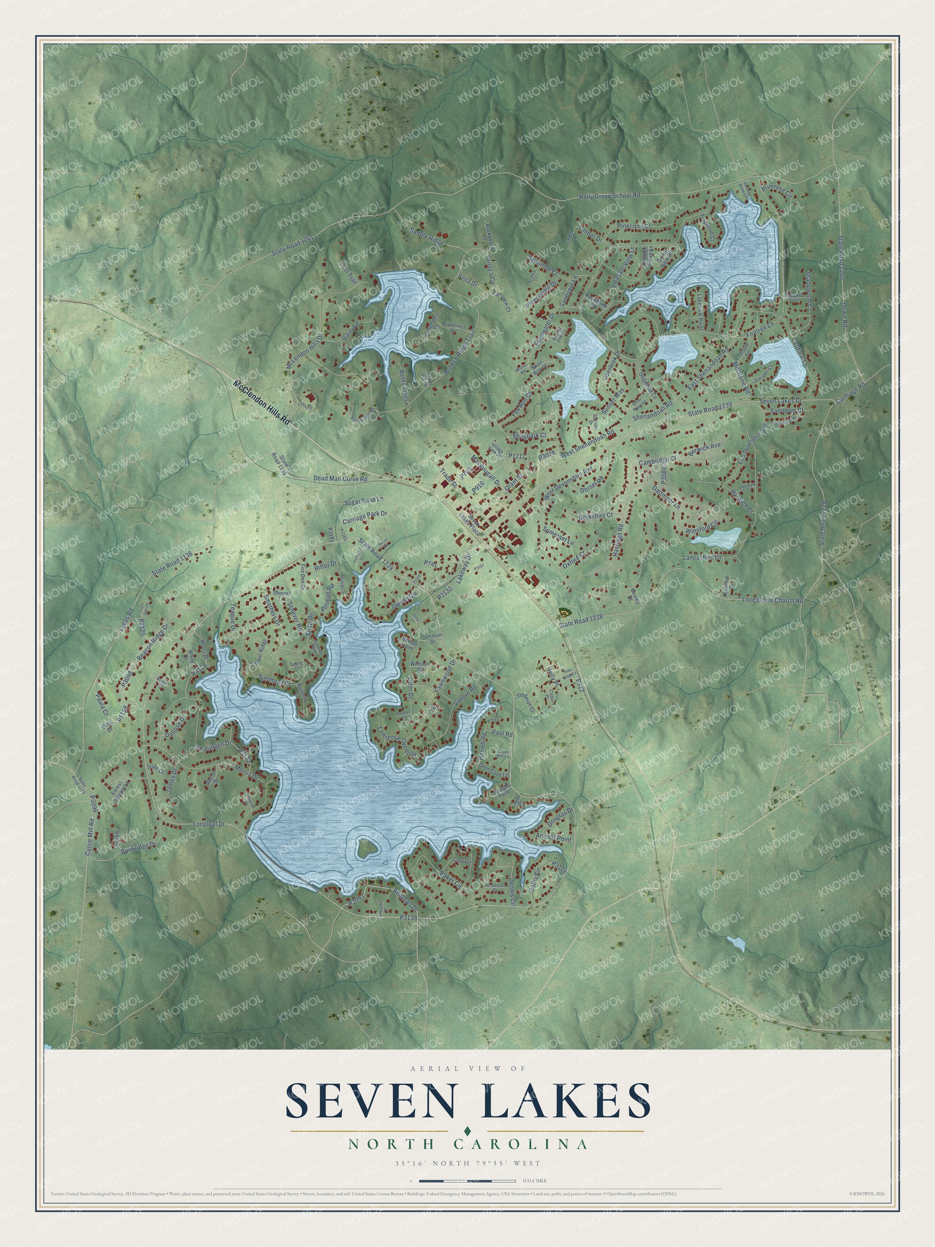
Explore Seven Lakes, North Carolina from a whole new perspective. Created using aerial imagery and detailed geographic data, this map captures Seven Lakes building by building, with labeled streets, familiar landmarks, and shaded topographical relief that highlights the natural contours of the landscape.
Combining modern data with the timeless character of a vintage atlas, this map is just as interesting up close as it is beautiful on the wall. Whether you grew up in Seven Lakes, spent memorable years there, or call it home today, this unique map is a great way to celebrate a place that means something to you. Zoom in on the preview to look for your street, and then order a print to put your memories on the wall.
Three ways to hang it

Unframed archival matte, a black wood frame or a white wood frame.
Up close
Geography Worth Displaying
This map was created using accurate cartographic data and authoritative geographic sources, including the U.S. Geological Survey and the Census Bureau. The map brings together terrain, waterways, roads, and building detail. The majority of the streets are labeled, houses are accurately depicted, and the topography is derived from government sources. Combining local data with carefully composed color and shading leads to this beautifully detailed Seven Lakes artwork for your wall.
Rather than simply showing street outlines, we’ve included as many of the street names as we could reasonably fit on the map while keeping their names legible. Zoom in on the high resolution preview to see exactly what’s on the map. We truly set out to create a statement piece for anyone who loves Seven Lakes. So whether it’s for you, or a gift for someone you love, we hope this map of Seven Lakes brings back fond memories.
Read the story behind this map of Seven Lakes, North Carolina from 2026.

Find your street
Names on the Seven Lakes map
Every name below is printed on this map. Look for your street, your school, the park where you played, or the pond down the road.
Streets and roads158
- McClendon Hills Road
- State Road 1224
- Andrews Drive
- Trade Street
- Shenandoah Road
- Lakeway Drive
- West Shenandoah Road
- Simmons Drive
- Saddle Ridge
- Longleaf Drive
- Holly Grove School Road
- State Road 1241
- Firetree Lane
- Lucas Road
- State Road 1136
- Seven Lakes Drive
- State Road 1239
- West Devonshire Avenue
- Broken Ridge Trail
- Love Grove Church Road
- State Road 1238
- Lancashire Lane
- Cardinal Lane
- Carthage Road
- State Road 1229
- Dowd Road
- State Road 1240
- James Drive
- Morris Drive
- McLendon Hills Drive
Show all 158 streets
- Edgewater Drive
- Hastings Road
- Banbridge Drive
- Overlook Drive
- Baker Circle
- Otter Drive
- Beacon Ridge Drive
- East Shenandoah Road
- Dead Man Curve Road
- Cristy's Circle
- Carriage Park Drive
- Sunset Way
- Winsford Circle
- Macdougall Drive
- Cambridge Court
- Smathers Drive
- Owens Circle
- Dennis Circle
- Fawnwood Drive
- Grant Street
- Shaw Drive
- Currie Mill Road
- Vanore Road
- Pleasant View Lane
- Swaringen Drive
- Pinecone Court
- Sugar Sand Lane
- Pineneedle Drive
- Shadywood Court
- Harwich Court
- Callis Circle
- Shagbark Court
- Gails Road
- Paula Court
- Lawrence Overlook
- Harrell Road
- Primrose Circle
- Dartmoor Lane
- Dorset Road
- Berkshire Court
- Oxford Court
- Millstone Road
- Sandspur Lane
- Somerset Lane
- Seminole Court
- Pittman Road
- Sandham Court
- Fox Run Court
- Schever Road
- Beths Point
- Timber Drive
- Teague Drive
- Douglas Drive
- Ritter Drive
- Anchor Point
- Holly Place
- Berwick Avenue
- Vista Drive
- Dubose Drive
- Paul Road
- Lost Trail
- East Devonshire Avenue
- Dogwood Circle
- State Road 1135
- Wertz Drive
- Cottage Grove Lane
- Clay Circle
- Winston Drive
- Forest Square Lane
- Trailcrest Drive
- Lakeview Point
- Brown Bark Road
- Seven Lakes Plaza
- Glen Cove Lane
- Buckboard Court
- Fox Den Drive
- Thistle Lane
- Timber Ridge
- Juniper Court
- White Drive
- Pinewood Court
- Stedman Court
- Jonathon's Drive
- Far View Court
- Cedar Lane
- Butterfly Court
- Swan Run Court
- Roundtree Road
- Sheroff Lane
- Josephs Point
- Baldwin Drive
- Rector Drive
- Oehman Drive
- Slate Court
- Sunset Point
- Bexley Court
- Villa Drive
- Troys Point
- State Road 1129
- Ruby Ridge Road
- Sherwood Road
- Village View Drive
- Dickerson Drive
- Phillips Drive
- Stallion Drive
- Cherokee Trail
- Azalea Court
- Sunrise Point
- Scarlet Oak Drive
- Drum Hill Court
- Mistic Road
- Logan Court
- Cedar Place
- Spong Court
- Carr Court
- Finch Gate Drive
- Sandy Ridge Road
- Pine Ridge Lane
- Patman Court
- Sheffield Lane
- Canyon Drive
- Heron Drive
- Lewallen Court
- Running Brook Lane
- Leewood Court
- Woodall Court
- Edwards Court
- Otter Court
Names are listed as they appear on the printed map. Zoom into the product photos to find them.
About Seven Lakes, North Carolina
Sanford businessman Fred Lawrence went quail hunting on rural land in West End in the early 1970s and followed his dog to a natural lake basin in the woods. He saw potential in the land, and he soon formed a partnership to buy 1,100 acres and began to develop what became Seven Lakes. The first homes were weekend and summer retreats on seven spring-fed lakes, the largest being Lake Sequoia.
Keep exploring North Carolina
Seven Lakes is one of 952 North Carolina towns we've mapped. Every dot on the map is a print of its own.
The search covers every state, North Carolina first.
Near Seven Lakes
Order 2 or more town maps and save 10%. Shown in the size and finish you picked above, so they hang as a set.
- West End 12" x 18" / Archival Matte Print $39.99
- Jackson Springs 12" x 18" / Archival Matte Print $39.99
- Foxfire 12" x 18" / Archival Matte Print $39.99
More maps nearby: Taylortown, Pinehurst, Candor, Norman and Carthage.
The art of mapping a place
How This Map Was Made
Real places. Remarkable detail. Discover the layers that turn geographic data into a map of home.

The view from above
Aerial imagery reveals the character of the land: woodland, open fields, and the patterns of a place.

The shape of the land
Elevation data brings hills, valleys, and subtle changes in the landscape into view.

The details of home
Roads, waterways, and building footprints come together to make the map feel unmistakably local.

Geography becomes art
Considered color, shading, and typography bring the layers together in a map made for your wall.


Process illustrated with Mendon, Massachusetts. Aerial imagery: USDA NAIP. Terrain: USGS 3D Elevation Program. Map details and finished artwork: KNOWOL.
The Details
About This Print
Choose an archival matte print, or a black or white Ayous wood frame. The archival matte print is unframed.
Select your size and finish above to see the matching product image and price.
Materials & Craftsmanship
A contemporary map with the character of a classic atlas, printed on archival matte paper. Optional frames are made from Ayous wood.
Your printed map does not include the watermark shown in the full-map preview.
Shipping & Delivery
Free shipping within the United States. Every print is made to order in the USA.
Buying a gift? Add a note in your cart and we'll include it. We never put prices in the package.
Prints ship within 2 to 3 business days. Allow 7 to 10 days total from ordering for delivery. Timing may vary during holidays or periods of high order volume.
Read our shipping policy.
Returns and damaged prints
Each print is made to order. Change-of-mind refunds are not available after production.
If your print arrives damaged, misprinted or incorrect, contact support@knowol.com within 30 days of receiving it. Include your order number, photos and a description of the issue.
Read our full refund and replacement policy. For questions about your order, email support@knowol.com.