
Search for another town


Free U.S. delivery 7 to 10 days after you order
Seven Springs, Florida Map Art
Building by building, with labeled streets and shaded relief.
12" x 18" Archival Matte Print
A Map of Home. A Work of Art.
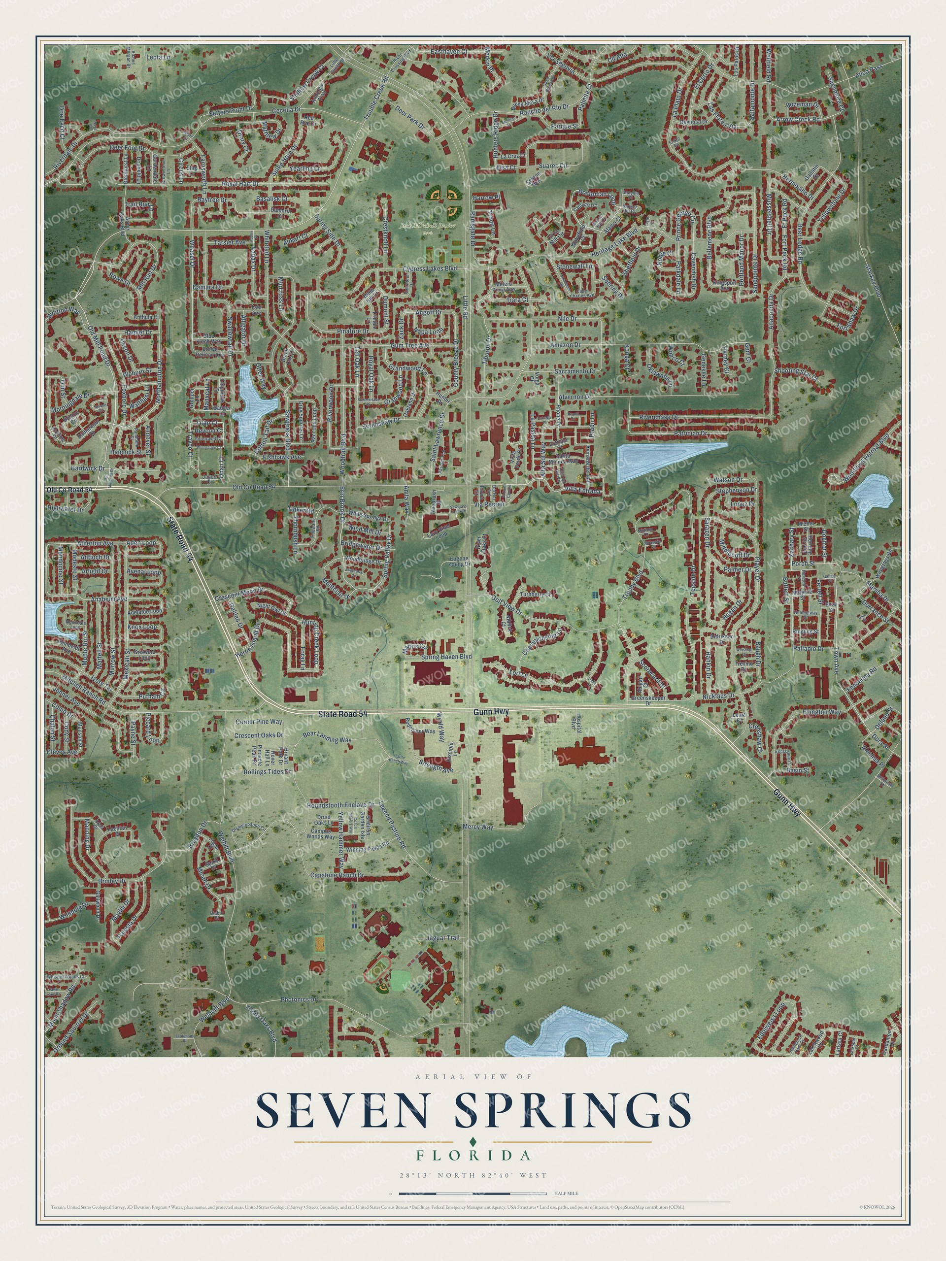
Explore Seven Springs, Florida from a whole new perspective. Created using aerial imagery and detailed geographic data, this map captures Seven Springs building by building, with labeled streets, familiar landmarks, and shaded topographical relief that highlights the natural contours of the landscape.
Combining modern data with the timeless character of a vintage atlas, this map is just as interesting up close as it is beautiful on the wall. Whether you grew up in Seven Springs, spent memorable years there, or call it home today, this unique map is a great way to celebrate a place that means something to you. Zoom in on the preview to look for your street, and then order a print to put your memories on the wall.
Three ways to hang it

Unframed archival matte, a black wood frame or a white wood frame.
Up close
Geography Worth Displaying
This map was created using accurate cartographic data and authoritative geographic sources, including the U.S. Geological Survey and the Census Bureau. The map brings together terrain, waterways, roads, and building detail. The majority of the streets are labeled, houses are accurately depicted, and the topography is derived from government sources. Combining local data with carefully composed color and shading leads to this beautifully detailed Seven Springs artwork for your wall.
Rather than simply showing street outlines, we’ve included as many of the street names as we could reasonably fit on the map while keeping their names legible. Zoom in on the high resolution preview to see exactly what’s on the map. We truly set out to create a statement piece for anyone who loves Seven Springs. So whether it’s for you, or a gift for someone you love, we hope this map of Seven Springs brings back fond memories.
Read the story behind this map: Detailed Map of Seven Springs, Florida.

Find your street
Names on the Seven Springs map
Every name below is printed on this map. Look for your street, your school, the park where you played, or the pond down the road.
Places and landmarks1
- Jack Mitchell Junior Park
Streets and roads375
- State Road 54
- Gunn Highway
- Town Avenue
- Alta Sol Way
- Villa Entrada
- Travco Court
- Onan Court
- Deland Street
- Titan Court
- Old Mill Pond Drive
- Bostonian Loop
- Northampton Drive
- Atherton Avenue
- Erin Brook Drive
- Trouble Creek Road
- Weasel Drive
- Spring Valley Drive
- Hunting Creek Loop
- Anaheim Avenue
- Baytree Drive
- Montclair Drive
- Arrow Creek Road
- Prince George Circle
- Angoff Drive
- Little Road
- Starkey Boulevard
- Photonics Drive
- Cecelia Drive
- Old County Road 54
- Heritage Lake Boulevard
Show all 375 streets
- Saint Lawrence Drive
- Player Drive
- Welbilt Boulevard
- Trophy Boulevard
- Swallowtail Drive
- Deer Lodge Road
- Capstone Ranch Drive
- Mitchell Ranch Road
- Alico Pass
- Sawgrass Boulevard
- Amazon Drive
- Teeside Drive
- Royal Hart Drive
- Bear Landing Way
- Brinley Drive
- Rancho del Rio Drive
- Nicklaus Drive
- Cypress Lakes Boulevard
- Mexicali Street
- Alvernon Drive
- Deer Foot Drive
- Legend Pasture Road
- Hermosillo Drive
- Lori Lane
- Via Segovia
- Anaconda Drive
- Golf View Drive
- Suarez Circle
- Woodtrail Boulevard
- Riverdale Drive
- Murrow Street
- Whitetail Lane
- Sacramento Drive
- Ellington Way
- Nile Drive
- Riverchase Drive
- Whitton Way
- Tiburon Drive
- Patrician Drive
- Musselshell Drive
- Spike Horn Drive
- Heron Island Drive
- Gum Tree Avenue
- Bellemede Boulevard
- Sebring Drive
- Mill Run Drive
- Sandpointe Drive
- Foxboro Drive
- Woodland Retreat Boulevard
- Jenner Avenue
- Palladio Drive
- Edelweiss Loop
- Sarazen Drive
- Fort Shaw Drive
- Matthew Drive
- Mercy Way
- Watson Drive
- Grandwood Lane
- Easthaven Court
- Pinafore Drive
- La Plata Drive
- Tall Oak Lane
- Crescent Moon Drive
- Spring Side Drive
- Putnam Circle
- Yellowstone Drive
- Welbuilt Boulevard
- County Breeze Drive
- Deer Park Drive
- Hardwick Drive
- Riverwood Drive
- El Cerro Drive
- Cll Alta
- Yearling Lane
- Monte Rio Street
- Shallow Creek Court
- Micah Drive
- Setters Point Drive
- Las Flores Via
- Ivory Terrace
- Sheffield Drive
- Marsha Drive
- Martell Street
- Granwood Lane
- Saltamonte Drive
- Knox Loop
- Avenal Loop
- Aden Loop
- Palmer Drive
- Hogan Drive
- Alligator Drive
- Ramsgate Drive
- Morningdale Drive
- Ferrell Street
- Ground Squirrel Drive
- Houndstooth Enclave Drive
- Palesta Drive
- Championship Lane
- Maylin Drive
- Moon Shadow Road
- Portland Manor Drive
- Fishhawk Avenue
- Wellfield Road
- Hunters Ridge Drive
- Braydon Drive
- Rollings Tides Drive
- Rowe Drive
- Strength Avenue
- Yellow Hammer Way
- Fenceline Road
- Crescent Oaks Drive
- Manning Drive
- Crestknoll Lane
- Trail Run Lp
- Damara Drive
- Doe Eyed Court
- Hamlet Drive
- Spring Haven Boulevard
- Addax Drive
- Dumont Street
- Piccard Loop
- Farnsworth Lane
- Trinity Oaks Boulevard
- Highwater Drive
- Oklawaha Lane
- Scorecard Drive
- Via Recreo
- Middlecoff Drive
- Napa Loop
- Scrimshaw Drive
- Tinker Road
- La Pasida Lane
- Bozeman Drive
- Wimpole Drive
- Manxcat Lane
- Galileo Drive
- Rankin Drive
- Cotton Tail Drive
- Tiara Court
- Andover Street
- Royal Oak Lane
- Durrance Street
- World Way
- Porch Street
- Bridgewater Drive
- Stonewall Lane
- Parkdale Lane
- Jaguar Trail
- Cavendish Drive
- Mendocino Street
- Modesto Street
- Murcross Lane
- Leota Lane
- Noble Court
- Merkin Place
- Corner Pine Way
- Shooting Star Court
- Foray Lane
- Stephenson Drive
- Chalon Street
- Wind Mill Drive
- Tarsier Avenue
- Alachua Place
- Olin Street
- Baugh Drive
- Basin Street
- Payne Street
- Aukari Court
- Genesee Lane
- Thornbush Lane
- Otter Way
- Zachary Street
- Palmita Court
- Parque Street
- Fort Peck Road
- Lopez Drive
- Hancock Street
- Devon Drive
- Como Drive
- Sagamore Court
- Drury Court
- Basalisk Court
- Manos Circle
- Buffett Street
- Cody Street
- Konga Court
- Waltham Lane
- Ft Peck Road
- Crenshaw Court
- Woburn Street
- Prado Lane
- Arlight Drive
- Antioch Drive
- Cleves Avenue
- Dogtrot Street
- Anita Way
- Zack Drive
- Harney Court
- Revcon Court
- Circus Lane
- Troon Lane
- Harrow Place
- Dora Street
- Wimco Court
- Gem Court
- Elsa Court
- Larchwood Court
- Vista Verde Drive
- White Springs Drive
- Grist Mill Circle
- Raccoon Loop
- Lazy River Loop
- Griswold Loop
- Adelaide Loop
- Wiregrass Road
- Boston Circle
- Lachlan Drive
- Eugene Young Drive
- Arbor Oaks Boulevard
- Campus Woods Way
- Winning Fields Road
- Rhone Drive
- Oakland Drive
- Black Fox Drive
- Greenskeeper Drive
- Brown Pelican Avenue
- Pinnacle Peak Drive
- Bryant Park Drive
- Avinada del Mar
- Redeemer Way
- Glenhurst Lane
- Reynosa Drive
- Gallatin Drive
- Gridiron Garden Isle
- Woodbridge Drive
- Humboldt Avenue
- Santa Monica Way
- Gray Squirrel Lane
- River Oaks Court
- Buena Mesa Drive
- Disciple Lane
- Spirit Court
- Blue Finch Way
- Tahr Avenue
- Doefield Lane
- Badger Lane
- Herlong Strreet
- Woodrush Street
- Los Palos Drive
- Millers Pond Avenue
- Trimble Lane
- Druid Oaks Lane
- Night Owl Court
- Grouper Lane
- Mizner Street
- Chipmunk Drive
- Gailwood Drive
- Larissa Court
- La Cruz Court
- Gardendale Lane
- Kingsport Avenue
- Balharbour Drive
- Cardamon Drive
- Turnberry Court
- Hospital Boulevard
- Selene Way
- Anthula Court
- Wakefield Court
- Marjorie Street
- Munson Street
- Lema Court
- Ringling Street
- Niblick Court
- Didrikson Drive
- Estrella Court
- Knob Hill Court
- Alamo Court
- Abigail Court
- Anhinga Trail
- Trevino Drive
- Hunter Drive
- Stag Lane
- Hover Hall Lane
- Cambria Court
- Jayco Court
- Elvira Court
- Red Roe Drive
- Bosk Street
- Volga Court
- McClung Drive
- Casa Nueva Drive
- Little Creek Drive
- Olympic Stone Circle
- Passport Lane
- Montague Loop
- Volunteer Drive
- Tidewater Road
- Cape Charles Avenue
- Whisper Woods Court
- River Crossing Boulevard
- Arelli Drive
- Foretravel Court
- Esplanade Drive
- Hammock Park Court
- Flagler Court
- Brownstone Lane
- Hemingway Street
- Randolph Street
- Cathedral Court
- Larkspur Court
- Hurston Street
- Adams Morgan Drive
- Defuniak Street
- Del Rio Avenue
- Danville Court
- Bunker Hill Court
- Midiron Court
- Brassie Court
- Diablo Court
- El Sol Court
- Revere Circle
- Summerlake Drive
- Cattle Ranch Way
- Jacinto Street
- Avanti Circle
- Coachmen Road
- Old Millpond Drive
- Winnebago Court
- Casa del Sol Way
- Coach Manors Way
- Weiskopf Drive
- Fawn Lake Road
- Sweetbriar Court
- Evolutions Place
- Estrada Place
- Links Lane
- Gallery Street
- Sawgrass Creek Drive
- Bedford Mall Court
- El Canti Camino
- Diaz Street
- Worth Court
- Addox Drive
- Leyte Court
- Nova Court
Names are listed as they appear on the printed map. Zoom into the product photos to find them.
About Seven Springs, Florida
Samuel H. and Elizabeth Stevenson were among the early residents of Seven Springs. Elizabeth believed the water of the Anclote River could heal, so the area began as a health resort. One of West Pasco's first tourist homes opened here, and several hotels followed.
Seven Springs School taught local children from 1913 to 1925. In 1981, the old school building was given to the West Pasco Historical Society. It was moved to Sims Park, where it now serves as a museum and library.
Keep exploring Florida
Seven Springs is one of 1,067 Florida towns we've mapped. Every dot on the map is a print of its own.
The search covers every state, Florida first.
Near Seven Springs
Order 2 or more town maps and save 10%. Shown in the size and finish you picked above, so they hang as a set.
- Trinity 12" x 18" / Archival Matte Print $39.99
- Elfers 12" x 18" / Archival Matte Print $39.99
- New Port Richey East 12" x 18" / Archival Matte Print $39.99


More maps nearby: New Port Richey, River Ridge, Holiday, Beacon Square and Port Richey.
The art of mapping a place
How This Map Was Made
Real places. Remarkable detail. Discover the layers that turn geographic data into a map of home.

The view from above
Aerial imagery reveals the character of the land: woodland, open fields, and the patterns of a place.

The shape of the land
Elevation data brings hills, valleys, and subtle changes in the landscape into view.

The details of home
Roads, waterways, and building footprints come together to make the map feel unmistakably local.

Geography becomes art
Considered color, shading, and typography bring the layers together in a map made for your wall.


Process illustrated with Mendon, Massachusetts. Aerial imagery: USDA NAIP. Terrain: USGS 3D Elevation Program. Map details and finished artwork: KNOWOL.
The Details
About This Print
Choose an archival matte print, or a black or white Ayous wood frame. The archival matte print is unframed.
Select your size and finish above to see the matching product image and price.
Materials & Craftsmanship
A contemporary map with the character of a classic atlas, printed on archival matte paper. Optional frames are made from Ayous wood.
Your printed map does not include the watermark shown in the full-map preview.
Shipping & Delivery
Free shipping within the United States. Every print is made to order in the USA.
Buying a gift? Add a note in your cart and we'll include it. We never put prices in the package.
Prints ship within 2 to 3 business days. Allow 7 to 10 days total from ordering for delivery. Timing may vary during holidays or periods of high order volume.
Read our shipping policy.
Returns and damaged prints
Each print is made to order. Change-of-mind refunds are not available after production.
If your print arrives damaged, misprinted or incorrect, contact support@knowol.com within 30 days of receiving it. Include your order number, photos and a description of the issue.
Read our full refund and replacement policy. For questions about your order, email support@knowol.com.