


Search for another town


Free U.S. delivery 7 to 10 days after you order
Sevierville, Tennessee Map Art
Building by building, with labeled streets and shaded relief.
12" x 18" Archival Matte Print
A Map of Home. A Work of Art.
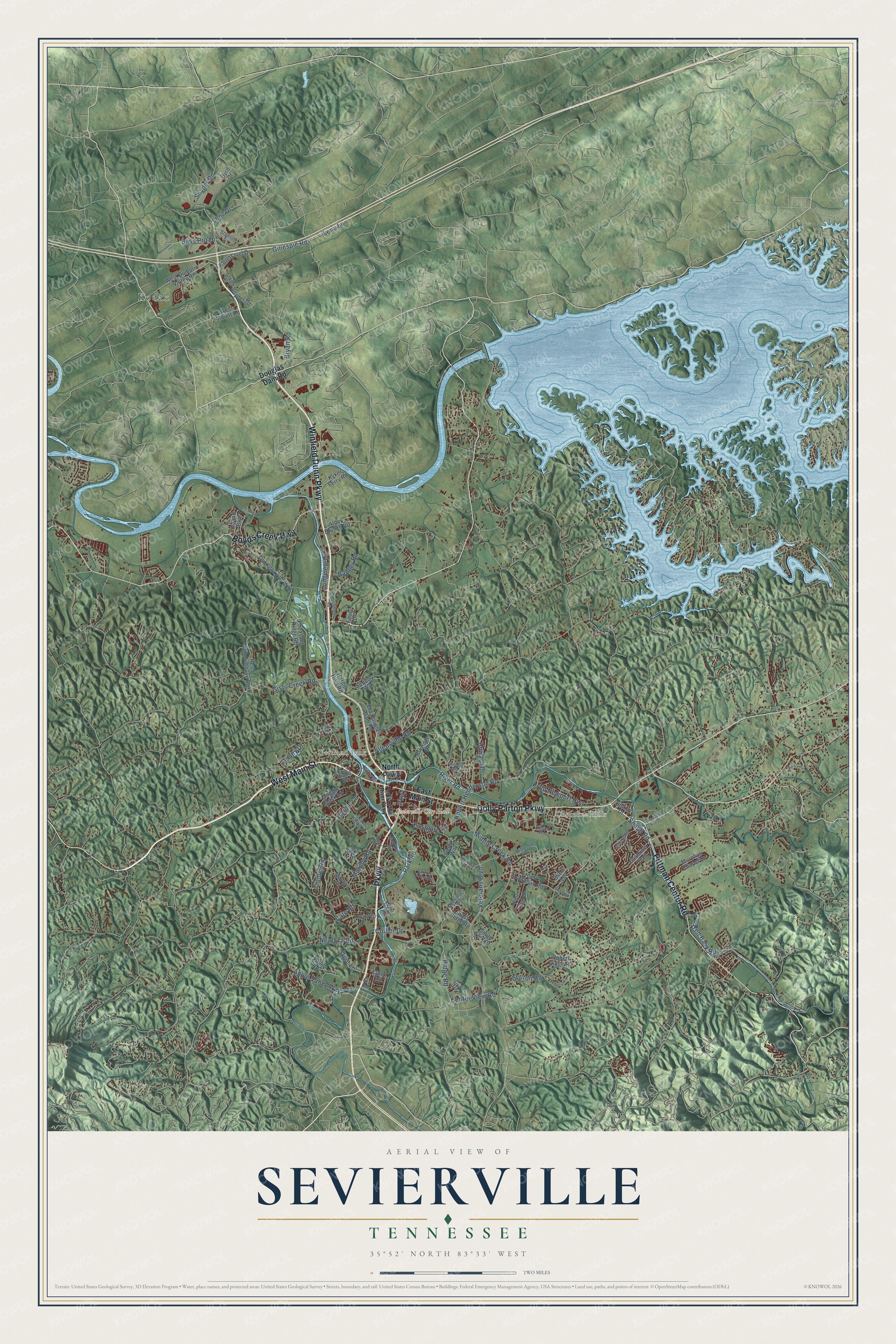
Explore Sevierville, Tennessee from a whole new perspective. Created using aerial imagery and detailed geographic data, this map captures Sevierville building by building, with labeled streets, familiar landmarks, and shaded topographical relief that highlights the natural contours of the landscape.
Combining modern data with the timeless character of a vintage atlas, this map is just as interesting up close as it is beautiful on the wall. Whether you grew up in Sevierville, spent memorable years there, or call it home today, this unique map is a great way to celebrate a place that means something to you. Zoom in on the preview to look for your street, and then order a print to put your memories on the wall.
Three ways to hang it

Unframed archival matte, a black wood frame or a white wood frame.
Up close
Geography Worth Displaying
This map was created using accurate cartographic data and authoritative geographic sources, including the U.S. Geological Survey and the Census Bureau. The map brings together terrain, waterways, roads, and building detail. The majority of the streets are labeled, houses are accurately depicted, and the topography is derived from government sources. Combining local data with carefully composed color and shading leads to this beautifully detailed Sevierville artwork for your wall.
Rather than simply showing street outlines, we’ve included as many of the street names as we could reasonably fit on the map while keeping their names legible. Zoom in on the high resolution preview to see exactly what’s on the map. We truly set out to create a statement piece for anyone who loves Sevierville. So whether it’s for you, or a gift for someone you love, we hope this map of Sevierville brings back fond memories.
Read the story behind this map of Sevierville, Tennessee from 2026.

Find your street
Names on the Sevierville map
Every name below is printed on this map. Look for your street, your school, the park where you played, or the pond down the road.
Places and landmarks4
- Sevierville City Hall
- Kodak
- Cherokee Hills
- Yettland Park
Streets and roads96
- Parkway
- West Main Street
- Dolly Parton Parkway
- Winfield Dunn Parkway
- Boyds Creek Highway
- Pittman Center Road
- Old Newport Highway
- Hardin Lane
- New Era Road
- Collier Drive
- Veterans Boulevard
- Middle Creek Road
- Ridge Road
- Park Road
- Eastgate Road
- Apple Valley Way
- Snyder Road
- Robert Henderson Road
- Tramel Road
- Gists Creek Road
- Red Bank Road
- Cate Road
- Denton Road
- Bryan Road
- Snapp Road
- Center View Road
- Howard Drive
- Allensville Road
- Jersey Drive
- Bass Pro Drive
Show all 96 streets
- Badger Road
- Longview Drive
- Murphy Road
- Lena Lane
- Gillespie Road
- Ogle Lane
- River Road
- Lenz Drive
- North Parkway
- East Main Street
- Douglas Dam Road
- West Dumplin Valley Road
- Emily Drive
- Old Knoxville Highway
- Kyker Ferry Road
- Reed Schoolhouse Road
- Burridge Drive
- Ernest McMahan Road
- Maggie Mack Lane
- Old Douglas Dam Road
- Murphys Chapel Drive
- Jasmine Trail
- Valley Road
- South Snyder Road
- Robert Ridge Road
- Hicks Drive
- South Fork Drive
- Fine Glen Drive
- Alder Branch Road
- Foretravel Drive
- Ella Drive
- Posty Way
- Hardin Hills Road
- East Ridge Road
- Blake Lea
- Lynn Drive
- Island Boulevard
- Pheasant Ridge Road
- West Mount Road
- Mayors Drive
- Sequoya Way
- Caton Road
- Kilby Street
- Byrd Drive
- Dickey Drive
- Hazel Drive
- Catlett Road
- Millwood Drive
- Rivergate Drive
- East Hardin Lane
- London Lane
- Mechanics Way
- Stadium Drive
- Markhill Drive
- Airport Road
- Cody Drive
- Fox Road
- Forks of the River Parkway
- Old State Route 35
- Bogart Drive
- Shannon Circle
- Sugarland Lane
- Catlettsburg Road
- Country Colonial Street
- Briar Lea
- Webb Lane Way
Names are listed as they appear on the printed map. Zoom into the product photos to find them.
About Sevierville, Tennessee
Sevierville is a city of 17,889 people and the county seat of Sevier County, in East Tennessee. In 1783 the trader Isaac Thomas, a man the Cherokee respected, opened a farm, a trading post and a tavern where the West Fork joins the Little Pigeon River. Spencer Clack and James McMahan soon settled beside him, and the place became known as Forks of the Little Pigeon. Sevier County was formed in 1794 and named for John Sevier, who had beaten the Cherokee at nearby Boyd's Creek in 1780. In 1795 a meeting at Thomas's house picked the Forks as the county seat and renamed it Sevierville.
McMahan gave 25 acres for a town square, cut into half-acre lots, and every buyer had to put up a building of brick, frame or stone. In 1856 a fire burned the new courthouse, 41 houses and several shops, and the county lost nearly all of its early records. Another fire wrecked much of downtown in 1900, so businesses left the old square on Main Street for Court Avenue and Bruce Street, around the new courthouse. Sevierville was incorporated the next year, in 1901.
“I feel this morning like nothing but destruction awaits us.”
- A courthouse by 1796Local legend says the first county court met in an empty stable full of fleas. As the story goes, fed-up lawyers paid someone a bottle of whiskey to set it on fire, and the county had to build a real courthouse, which went up in 1796.
- A Union town in 1861When Tennessee voted on secession in 1861, only 3.8% of Sevier County voters were in favor. A year later the Knoxville editor Parson Brownlow spoke against secession here, and his crowd stayed up all night on a rumor that Confederate troops were coming. Both armies looted the crossroads town in 1863 and 1864, and at the war's end most remaining Confederate sympathizers, among them the Brabson family, had to flee.
- Built by Dockery and BucknerAfter the Civil War, two Black craftsmen led Sevierville's building boom. Brickmason Isaac Dockery raised the walls of the Sevier County Courthouse in 1896, ten years after he finished New Salem Baptist Church in 1886, and both still stand. The courthouse joined the National Register in 1971 and the church in 2003. House builder Lewis Buckner designed homes around town for 40 years, and 15 of them survive.
- Whitecaps and Blue BillsIn 1892 a hooded vigilante band called the Whitecaps set out to rid the county of vice. Sevierville doctor J.A. Henderson took over a rival group in 1893 and named it the Blue Bills, and the two sides fought at Henderson Springs in 1894, with deaths on both sides. After the Whitecaps murdered a young Sevierville couple in 1896, the state banned vigilante groups in 1898, and the Whitecaps faded away by the end of the century.
Keep exploring Tennessee
Sevierville is one of 640 Tennessee towns we've mapped. Every dot on the map is a print of its own.
The search covers every state, Tennessee first.
Near Sevierville
Order 2 or more town maps and save 10%. Shown in the size and finish you picked above, so they hang as a set.
- Boyds Creek 12" x 18" / Archival Matte Print $39.99
- Pigeon Forge 12" x 18" / Archival Matte Print $39.99
- Fairgarden 12" x 18" / Archival Matte Print $39.99


More maps nearby: Piedmont, Seymour, Carter, Gatlinburg and Prospect.
The art of mapping a place
How This Map Was Made
Real places. Remarkable detail. Discover the layers that turn geographic data into a map of home.

The view from above
Aerial imagery reveals the character of the land: woodland, open fields, and the patterns of a place.

The shape of the land
Elevation data brings hills, valleys, and subtle changes in the landscape into view.

The details of home
Roads, waterways, and building footprints come together to make the map feel unmistakably local.

Geography becomes art
Considered color, shading, and typography bring the layers together in a map made for your wall.


Process illustrated with Mendon, Massachusetts. Aerial imagery: USDA NAIP. Terrain: USGS 3D Elevation Program. Map details and finished artwork: KNOWOL.
The Details
About This Print
Choose an archival matte print, or a black or white Ayous wood frame. The archival matte print is unframed.
Select your size and finish above to see the matching product image and price.
Materials & Craftsmanship
A contemporary map with the character of a classic atlas, printed on archival matte paper. Optional frames are made from Ayous wood.
Your printed map does not include the watermark shown in the full-map preview.
Shipping & Delivery
Free shipping within the United States. Every print is made to order in the USA.
Buying a gift? Add a note in your cart and we'll include it. We never put prices in the package.
Prints ship within 2 to 3 business days. Allow 7 to 10 days total from ordering for delivery. Timing may vary during holidays or periods of high order volume.
Read our shipping policy.
Returns and damaged prints
Each print is made to order. Change-of-mind refunds are not available after production.
If your print arrives damaged, misprinted or incorrect, contact support@knowol.com within 30 days of receiving it. Include your order number, photos and a description of the issue.
Read our full refund and replacement policy. For questions about your order, email support@knowol.com.