
Search for another town


Free U.S. delivery 7 to 10 days after you order
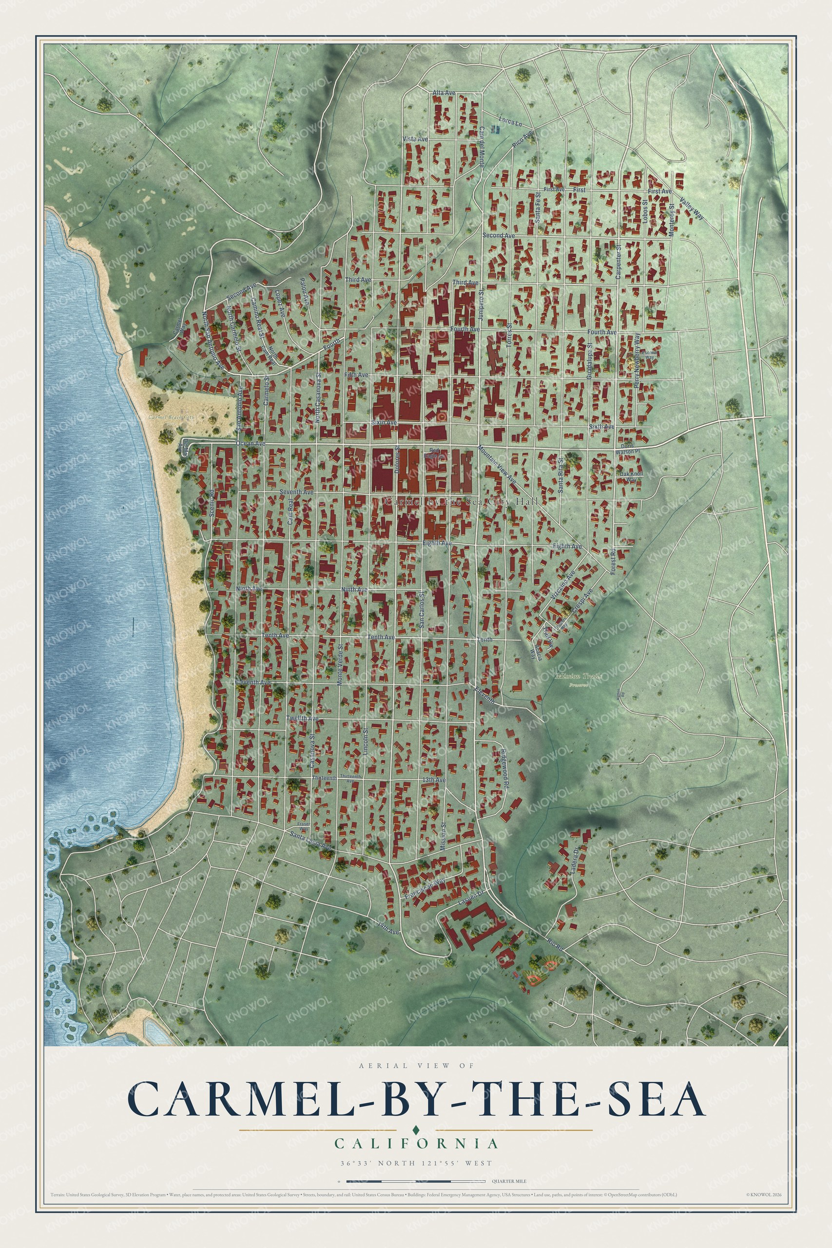
Carmel-by-the-Sea, California Map Art
Building by building, with labeled streets and shaded relief.
12" x 18" Archival Matte Print
A Map of Home. A Work of Art.
Explore Carmel-by-the-Sea, California from a whole new perspective. Created using aerial imagery and detailed geographic data, this map captures Carmel-by-the-Sea building by building, with labeled streets, familiar landmarks, and shaded topographical relief that highlights the natural contours of the landscape.
Combining modern data with the timeless character of a vintage atlas, this map is just as interesting up close as it is beautiful on the wall. Whether you grew up in Carmel-by-the-Sea, spent memorable years there, or call it home today, this unique map is a great way to celebrate a place that means something to you. Zoom in on the preview to look for your street, and then order a print to put your memories on the wall.
Three ways to hang it

Unframed archival matte, a black wood frame or a white wood frame.
Up close
Geography Worth Displaying
This map was created using accurate cartographic data and authoritative geographic sources, including the U.S. Geological Survey and the Census Bureau. The map brings together terrain, waterways, roads, and building detail. The majority of the streets are labeled, houses are accurately depicted, and the topography is derived from government sources. Combining local data with carefully composed color and shading leads to this beautifully detailed Carmel-by-the-Sea artwork for your wall.
Rather than simply showing street outlines, we’ve included as many of the street names as we could reasonably fit on the map while keeping their names legible. Zoom in on the high resolution preview to see exactly what’s on the map. We truly set out to create a statement piece for anyone who loves Carmel-by-the-Sea. So whether it’s for you, or a gift for someone you love, we hope this map of Carmel-by-the-Sea brings back fond memories.
Read the story behind this map of Carmel-by-the-Sea, California from 2026.

Find your street
Names on the Carmel-by-the-Sea map
Every name below is printed on this map. Look for your street, your school, the park where you played, or the pond down the road.
Places and landmarks3
- Carmel by the Sea City Hall
- Carmel Beach City Park
- Mission Trails Preserve
Streets and roads74
- Junipero Street
- Carpenter Street
- Ocean Avenue
- Cam del Monte
- North San Antonio Avenue
- Rio Road
- Fourth Avenue
- Dolores Street
- Forest Road
- Alta Avenue
- Fourth
- Second Avenue
- North Casanova Street
- Third Avenue
- Vizcaino Avenue
- Torres Street
- San Carlos Street
- Mission Street
- Lincoln Street
- Monte Verde Street
- San Antonio Avenue
- Scenic Road
- Cam Real
- Carmelo Street
- Santa Fe Street
- Casanova Street
- Eighth Avenue
- Guadalupe Street
- Santa Rita Street
- Eleventh Avenue
Show all 74 streets
- Fifth Avenue
- Sixth Avenue
- Santa Lucia Avenue
- Seventh Avenue
- First Avenue
- Tenth Avenue
- 13th Avenue
- Twelfth Avenue
- Ninth Avenue
- Mountain View Avenue
- Lobos Street
- Monterey Street
- Ridgewood Road
- Ladera Drive
- Lasuen Drive
- Camino Real Street
- Franciscan Way
- Perry Newberry Way
- North Carmelo Street
- Palou Avenue
- Valley Way
- Lopez Avenue
- Vista Avenue
- Crespi Avenue
- Lorca Lane
- First
- Eleventh
- Trail Vw
- Tenth
- Pico Avenue
- 14th Avenue
- Doris Watson Place
- Del Mar Avenue
- North Cam Real
- Acacia Way
- Oak Knoll Way
- Carmel Way
- Red Eagle Lane
- Thirteenth
- Fraser Way
- Thirteenth Avenue
- Escolle Way
- Flanders Way
- Hatton Road
Names are listed as they appear on the printed map. Zoom into the product photos to find them.
About Carmel-by-the-Sea, California
Carmel-by-the-Sea is a city of 3,220 people in Monterey County, on the Monterey Peninsula. In December 1771 Junípero Serra moved Mission San Carlos Borromeo de Carmelo here from Monterey, away from trouble between soldiers at the Presidio and the native people. The mission led California's whole chain of missions until Mexico's secularization act of 1833 split the land into ranchos. Serra died in 1784 and was buried in the mission church beside Juan Crespí.
By the time the United States took California in 1848, the old settlement was nearly empty. In 1888 a subdivision map for Honoré Escolle and Santiago J. Duckworth went on file with the county, and buyers had taken 200 lots by 1889. The Carmel Development Company, led by Frank Hubbard Powers and James Franklin Devendorf, laid out the core village in 1902, and builder Michael J. Murphy put up nearly 350 buildings there by 1940. Carmel incorporated in 1916.
“a village in a forest overlooking a white sand beach”
- Artists after the 1906 earthquakeNovelist Mary Austin, author of The Land of Little Rain, moved to Carmel in 1905, the year the Carmel Arts and Crafts Club formed. After the 1906 San Francisco earthquake, artists, writers and musicians fled the ruined city for Carmel, where they could buy a home lot for ten dollars down and pay off the rest as they were able. The club built its clubhouse on Casanova Street in 1907, and by 1914 it was known across the country.
- Shakespeare since 1911Carmel staged Twelfth Night in 1911, directed by Garnet Holme of UC Berkeley, with Perry Newberry and Herbert Heron in the cast years before each served as mayor. Newberry later wrote and directed a pageant honoring Father Serra, and in 1915 it played at the Panama-Pacific International Exposition in San Francisco to around twenty-five thousand people. Heron opened his first Carmel Shakespeare Festival in 1940 with Twelfth Night again.
- The Sunset School's auditoriumThe Sunset School, the only public school ever built inside the city, put up an auditorium in 1931 with Gothic-inspired lines and room for 700. The city bought it in 1964 and called it the Sunset Theatre. As the Sunset Center it joined the National Register in 1998, and after a $22 million renovation it reopened in 2003 with the 66th annual Carmel Bach Festival.
- A village without street numbersCarmel has spent its history guarding its trees and its small scale. New buildings have to be built around the trees already standing, and the village, which covers just one square mile, has neither street lights nor parking meters. Its homes and shops also went without street numbers for generations, until the city council voted in October 2025 to begin numbering buildings because more and more technology asked for an address.
Keep exploring California
Carmel-by-the-Sea is one of 1,990 California towns we've mapped. Every dot on the map is a print of its own.
The search covers every state, California first.
Near Carmel-by-the-Sea
Order 2 or more town maps and save 10%. Shown in the size and finish you picked above, so they hang as a set.
- Del Monte Forest 12" x 18" / Archival Matte Print $39.99
- Monterey 12" x 18" / Archival Matte Print $39.99
- Pacific Grove 12" x 18" / Archival Matte Print $39.99


More maps nearby: Del Rey Oaks, Sand City, Seaside, Carmel Valley Village and Marina.
The art of mapping a place
How This Map Was Made
Real places. Remarkable detail. Discover the layers that turn geographic data into a map of home.

The view from above
Aerial imagery reveals the character of the land: woodland, open fields, and the patterns of a place.

The shape of the land
Elevation data brings hills, valleys, and subtle changes in the landscape into view.

The details of home
Roads, waterways, and building footprints come together to make the map feel unmistakably local.

Geography becomes art
Considered color, shading, and typography bring the layers together in a map made for your wall.


Process illustrated with Mendon, Massachusetts. Aerial imagery: USDA NAIP. Terrain: USGS 3D Elevation Program. Map details and finished artwork: KNOWOL.
The Details
About This Print
Choose an archival matte print, or a black or white Ayous wood frame. The archival matte print is unframed.
Select your size and finish above to see the matching product image and price.
Materials & Craftsmanship
A contemporary map with the character of a classic atlas, printed on archival matte paper. Optional frames are made from Ayous wood.
Your printed map does not include the watermark shown in the full-map preview.
Shipping & Delivery
Free shipping within the United States. Every print is made to order in the USA.
Buying a gift? Add a note in your cart and we'll include it. We never put prices in the package.
Prints ship within 2 to 3 business days. Allow 7 to 10 days total from ordering for delivery. Timing may vary during holidays or periods of high order volume.
Read our shipping policy.
Returns and damaged prints
Each print is made to order. Change-of-mind refunds are not available after production.
If your print arrives damaged, misprinted or incorrect, contact support@knowol.com within 30 days of receiving it. Include your order number, photos and a description of the issue.
Read our full refund and replacement policy. For questions about your order, email support@knowol.com.