


Search for another town


Free U.S. delivery 7 to 10 days after you order
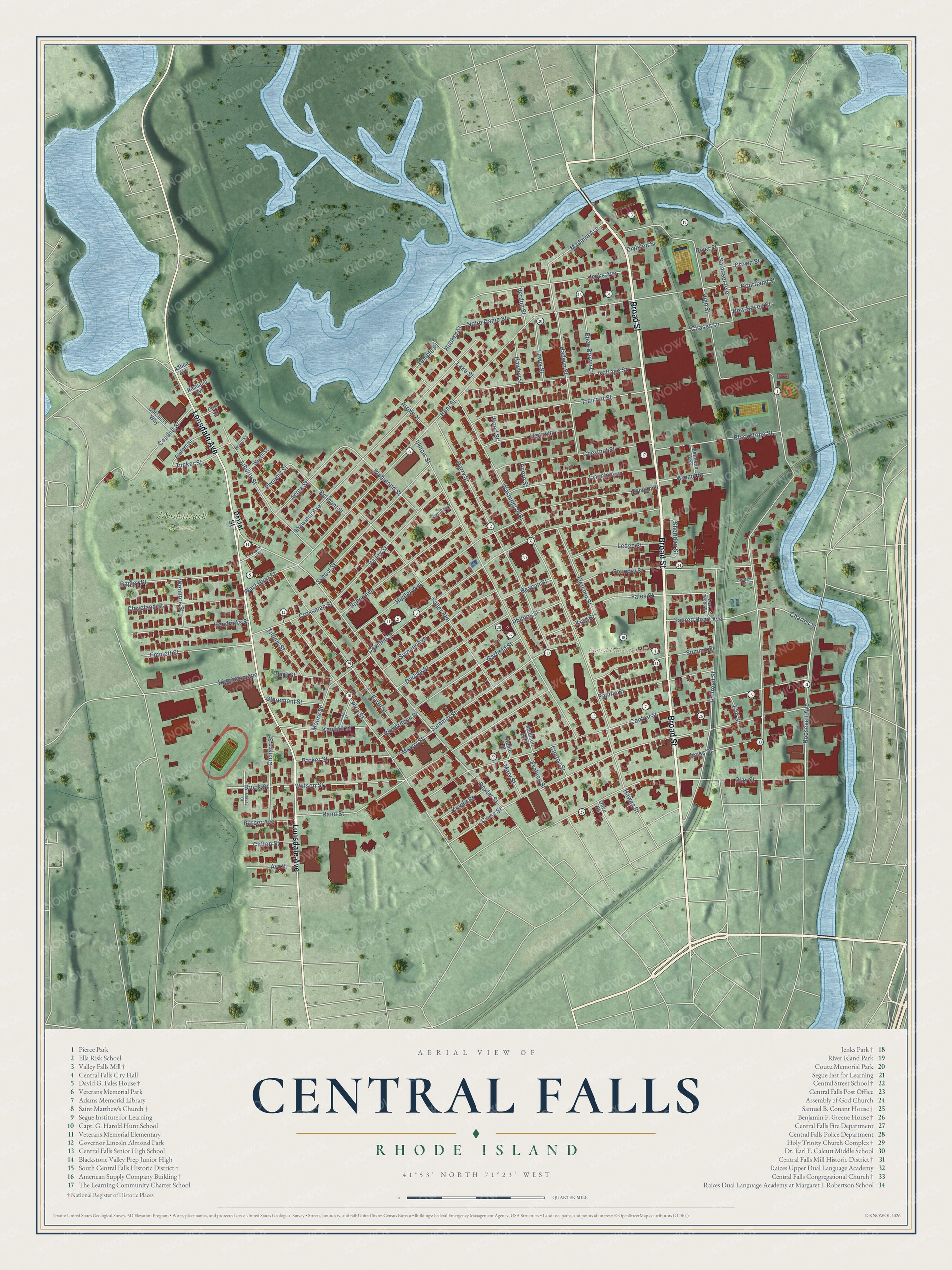
Central Falls, Rhode Island Map Art
Building by building, with labeled streets and shaded relief.
12" x 18" Archival Matte Print
A Map of Home. A Work of Art.
Explore Central Falls, Rhode Island from a whole new perspective. Created using aerial imagery and detailed geographic data, this map captures Central Falls building by building, with labeled streets, familiar landmarks, and shaded topographical relief that highlights the natural contours of the landscape.
Combining modern data with the timeless character of a vintage atlas, this map is just as interesting up close as it is beautiful on the wall. Whether you grew up in Central Falls, spent memorable years there, or call it home today, this unique map is a great way to celebrate a place that means something to you. Zoom in on the preview to look for your street, and then order a print to put your memories on the wall.
Three ways to hang it

Unframed archival matte, a black wood frame or a white wood frame.
Up close
Geography Worth Displaying
This map was created using accurate cartographic data and authoritative geographic sources, including the U.S. Geological Survey (USGS) and FEMA. The map brings together terrain, waterways, roads, and building detail. The majority of the streets are labeled, houses are accurately depicted, and the topography is derived from government sources. Combining local data with carefully composed color and shading leads to this beautifully detailed Central Falls artwork for your wall.
Rather than simply showing street outlines, we’ve included as many of the street names as we could reasonably fit on the map while keeping their names legible. Zoom in on the high resolution preview to see exactly what’s on the map. We truly set out to create a statement piece for anyone who loves Central Falls. So whether it’s for you, or a gift for someone you love, we hope this map of Central Falls brings back fond memories.
Explore the full map of Central Falls, Rhode Island and read about the local places it shows.

Find your street
Names on the Central Falls map
Every name below is printed on this map. Look for your street, your school, the park where you played, or the pond down the road.
Places and landmarks2
- Central Falls City Hall
- Moshassuck Cemetery
Streets and roads121
- Broad Street
- Lonsdale Avenue
- Dexter Street
- High Street
- Hunt Street
- Cross Street
- Central Street
- Washington Street
- Illinois Street
- Cowden Street
- Rand Street
- Pine Street
- Clay Street
- Shawmut Avenue
- Perry Street
- Railroad Street
- Fuller Avenue
- Tremont Street
- Hedley Avenue
- Earle Street
- Cottage Street
- Summer Street
- Roosevelt Avenue
- Liberty Street
- School Street
- Foundry Street
- Jenks Avenue
- Chestnut Street
- Valley Street
- Lincoln Avenue
Show all 121 streets
- Butler Avenue
- Hadwin Street
- Sylvian Street
- Sumner Avenue
- Conduit Street
- Darling Street
- Blackstone Street
- Fales Street
- Garfield Street
- Summit Street
- Bagley Street
- Madeira Avenue
- Cleveland Street
- Pacific Street
- Hendricks Street
- Higginson Avenue
- Emmett Street
- Watson Street
- Fletcher Street
- Orchard Street
- Richmond Street
- Moore Street
- Aetna Street
- Parker Street
- Ledge Street
- Sacred Heart Avenue
- Henry Street
- Kendall Street
- Jenks Street
- Hawes Street
- Crossman Street
- Samoset Avenue
- Belmont Street
- Brook Street
- Eben Brown Lane
- Lewis Street
- Charles Street
- Knight Street
- Temple Place
- West Hunt Street
- Sheridan Street
- Notre Dame Street
- Park Street
- Claremont Street
- Tiffany Street
- Lake Street
- Chases Lane
- King Street
- Beacon Street
- Walnut Street
- Phillips Street
- Barber Avenue
- Ayr Street
- Wetmore Street
- Mowry Street
- Courtland Street
- River Street
- Tucker Street
- Clifton Street
- Richardson Street
- Hawley Street
- Arrow Street
- Mary Street
- New Haven Street
- Phoenix Street
- Verdun Street
- Evaleen Street
- Crown Street
- Clinton Street
- Hooker Street
- Division Street
- Elm Street
- Hood Street
- Acorn Street
- Binford Street
- Dutchess Way
- Bellevue Avenue
- Worth Street
- Madison Avenue
- Cliff Street
- Richland Avenue
- Reed Avenue
- Hollie Street
- Echo Street
- Olive Street
- Althea Avenue
- East Wood Street
- George Street
- Chapel Street
- Prime Street
- Garvey Court
Names are listed as they appear on the printed map. Zoom into the product photos to find them.
About Central Falls, Rhode Island
Central Falls is a Providence County city of 22,583 people, packed into 1.29 square miles beside the Blackstone River, north of Pawtucket. In the 18th century Captain Stephen Jenks set up a trip hammer and a blacksmith shop by the river. Other manufacturers rented space in his building, a chocolate maker among them, so the village that grew up around it was called Chocolateville until Jenks proposed the name Central Falls in 1824, after the waterfall.
The village belonged to Smithfield until 1871, when that town broke into three and Central Falls ended up in Lincoln. Lincoln divided in turn in 1895, and Central Falls became a city of its own. Quakers were the first European settlers, then came Irish, Scottish and French Canadian immigrants, and in recent decades many Hispanic families. At the city's centennial parade in 1995, people from more than 100 countries took part.
- The ambush of March 26, 1676During King Philip's War, Captain Michael Pierce led Plymouth Colony troops and 20 Christian Wampanoag allies after a Narragansett band. Native scouts on Dexter's Ledge watched them come, and the Narragansett sprang an ambush along the river. Almost all of Pierce's men were killed. Nine were taken prisoner and later tortured to death in Cumberland, and a stone memorial called Nine Men's Misery marks their grave. Pierce Park now covers the battleground.
- Cogswell Tower since 1904Alvin Jenks donated the land for Jenks Park, and work on it began in 1890. Caroline Cogswell paid for the tower, which Pawtucket architect Albert H. Humes designed. It rises 70 feet, 18 feet square, on a brick vault atop Dexter's Ledge, and it has served as the city's symbol ever since. Jenks Park & Cogswell Tower joined the National Register in 1979.
- Six mills and a stone damBetween Roosevelt Avenue and the river, the Central Falls Mill Historic District takes in six mill buildings, built from 1825 to around 1910, along with a stone dam. Filled-in trenches there once carried water to the machines.
- The Valley Falls Mill of 1849On Broad Street, the Valley Falls Mill rose in 1849, a brick Italianate mill four stories tall. It had a dam, a gatehouse and canals of its own. Mill workers walked out in the New England Textile Strike of 1922 over a wage cut and longer hours, and the city's mills stood closed for a time.
- A mansard roof on High StreetThe David G. Fales House at 476 High Street dates to around 1858. Clifton A. Hall remodeled it in 1867 in the Second Empire style, adding a mansard roof, flared eaves set on brackets, and bay windows on two of its sides. The house was listed on the National Register in 1979.
Keep exploring Rhode Island
Central Falls is one of 86 Rhode Island towns we've mapped. Every dot on the map is a print of its own.
The search covers every state, Rhode Island first.
Near Central Falls
Order 2 or more town maps and save 10%. Shown in the size and finish you picked above, so they hang as a set.
- Saylesville 12" x 18" / Archival Matte Print $39.99
- Lonsdale 12" x 18" / Archival Matte Print $39.99
- Pawtucket 12" x 18" / Archival Matte Print $39.99


More maps nearby: Valley Falls, Lincoln, Wanskuck, North Providence and Ashton.
The art of mapping a place
How This Map Was Made
Real places. Remarkable detail. Discover the layers that turn geographic data into a map of home.

The view from above
Aerial imagery reveals the character of the land: woodland, open fields, and the patterns of a place.

The shape of the land
Elevation data brings hills, valleys, and subtle changes in the landscape into view.

The details of home
Roads, waterways, and building footprints come together to make the map feel unmistakably local.

Geography becomes art
Considered color, shading, and typography bring the layers together in a map made for your wall.


Process illustrated with Mendon, Massachusetts. Aerial imagery: USDA NAIP. Terrain: USGS 3D Elevation Program. Map details and finished artwork: KNOWOL.
The Details
About This Print
Choose an archival matte print, or a black or white Ayous wood frame. The archival matte print is unframed.
Select your size and finish above to see the matching product image and price.
Materials & Craftsmanship
A contemporary map with the character of a classic atlas, printed on archival matte paper. Optional frames are made from Ayous wood.
Your printed map does not include the watermark shown in the full-map preview.
Shipping & Delivery
Free shipping within the United States. Every print is made to order in the USA.
Buying a gift? Add a note in your cart and we'll include it. We never put prices in the package.
Prints ship within 2 to 3 business days. Allow 7 to 10 days total from ordering for delivery. Timing may vary during holidays or periods of high order volume.
Read our shipping policy.
Returns and damaged prints
Each print is made to order. Change-of-mind refunds are not available after production.
If your print arrives damaged, misprinted or incorrect, contact support@knowol.com within 30 days of receiving it. Include your order number, photos and a description of the issue.
Read our full refund and replacement policy. For questions about your order, email support@knowol.com.