
Search for another town


Free U.S. delivery 7 to 10 days after you order
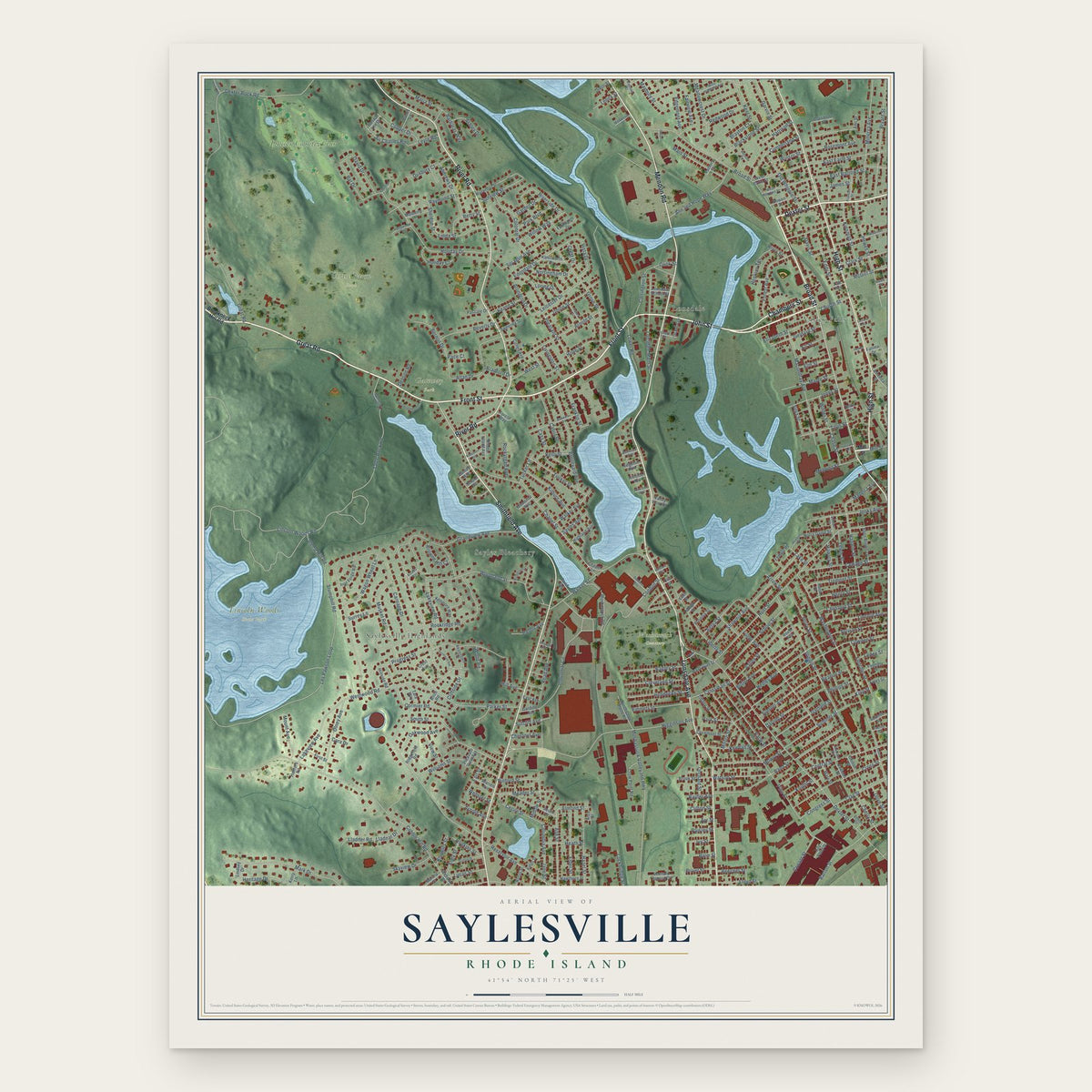
Saylesville, Rhode Island Map Art
Building by building, with labeled streets and shaded relief.
12" x 18" Archival Matte Print
A Map of Home. A Work of Art.
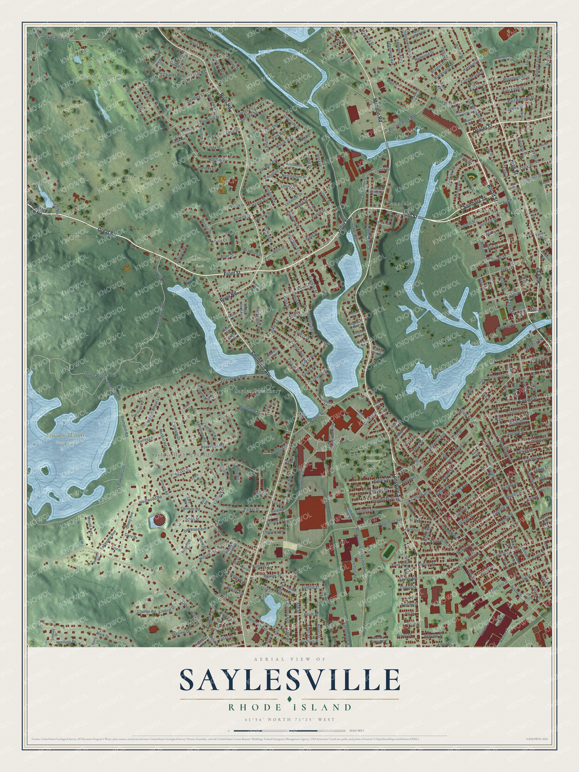
Explore Saylesville, Rhode Island from a whole new perspective. Created using aerial imagery and detailed geographic data, this map captures Saylesville building by building, with labeled streets, familiar landmarks, and shaded topographical relief that highlights the natural contours of the landscape.
Combining modern data with the timeless character of a vintage atlas, this map is just as interesting up close as it is beautiful on the wall. Whether you grew up in Saylesville, spent memorable years there, or call it home today, this unique map is a great way to celebrate a place that means something to you. Zoom in on the preview to look for your street, and then order a print to put your memories on the wall.
Three ways to hang it

Unframed archival matte, a black wood frame or a white wood frame.
Up close
Geography Worth Displaying
This map was created using accurate cartographic data and authoritative geographic sources, including the U.S. Geological Survey and the Census Bureau. The map brings together terrain, waterways, roads, and building detail. The majority of the streets are labeled, houses are accurately depicted, and the topography is derived from government sources. Combining local data with carefully composed color and shading leads to this beautifully detailed Saylesville artwork for your wall.
Rather than simply showing street outlines, we’ve included as many of the street names as we could reasonably fit on the map while keeping their names legible. Zoom in on the high resolution preview to see exactly what’s on the map. We truly set out to create a statement piece for anyone who loves Saylesville. So whether it’s for you, or a gift for someone you love, we hope this map of Saylesville brings back fond memories.
Read the story behind this map: Detailed Map of Saylesville, Rhode Island.

Find your street
Names on the Saylesville map
Every name below is printed on this map. Look for your street, your school, the park where you played, or the pond down the road.
Places and landmarks9
- Chase Farm Park
- Lincoln Woods State Park
- Moshassuck Cemetery
- Gateway Park
- Valley Falls
- Lonsdale
- Saylesville Highlands
- Sayles Bleachery
- Lincoln Country Club
Streets and roads365
- Front Street
- Great Road
- John Street
- Broad Street
- Dexter Street
- Chambers Street
- Lonsdale Avenue
- Smithfield Avenue
- River Road
- High Street
- Mendon Road
- Grandview Avenue
- Westwood Road
- Edendale Drive
- Arlington Drive
- Columbia Avenue
- Almond Street
- Stump Hill Road
- Lincoln Woods Road
- Carriage Drive
- Cobble Hill Road
- Reservoir Avenue
- Hunt Street
- Pine Street
- Les Pawson Loop
- Washington Street
- Parker Street
- Higginson Avenue
- Dexter Rock Road
- Chapel Street
Show all 365 streets
- Illinois Street
- Grove Street
- Progress Street
- Holiday Drive
- Moshassuck Valley Ind Highway
- Cowden Street
- Rand Street
- Shawmut Avenue
- Woodland Street
- Smith Street
- Rockridge Road
- Perry Street
- Pleasant Street
- Industrial Circle
- Cottage Street
- Mark Drive
- Minerva Avenue
- Fuller Avenue
- Table Rock Road
- Bryant Street
- Fairview Avenue
- Oakwood Avenue
- Central Street
- Macondray Avenue
- Walker Street
- Vista Drive
- Hewes Street
- Boulevard Avenue
- Cross Street
- Hedley Avenue
- Arnold Street
- Earle Street
- Lonsdale Main Street
- Conduit Street
- Barton Street
- School Street
- Tucker Street
- Summer Street
- Williams Street
- Liberty Street
- Lincoln Avenue
- Titus Street
- Lakeview Road
- Musket Road
- Middle Street
- Blackstone Street
- Tremont Street
- Jenks Avenue
- Valley Street
- East Earle Street
- Ann and Hope Way
- Lakeview Avenue
- Butler Avenue
- Wood Road
- Forest Avenue
- Carrington Street
- Hazel Street
- Elder Street
- Cormier Road
- Olney Avenue
- Franklin Street
- Hadwin Street
- East Barrows Street
- Kinsman Street
- Maria Street
- Bradford Drive
- Sumner Avenue
- Bernon Drive
- Meadowcrest Drive
- Raymond Street
- Colonial Drive
- Chestnut Street
- Darling Street
- Sprague Avenue
- Ash Street
- Cumberland Street
- Garfield Street
- Read Avenue
- Binford Street
- Old Whipple Street
- Jones Street
- Cabot Street
- Riverside Drive
- Bagley Street
- Wagon Wheel Lane
- Madeira Avenue
- Cleveland Street
- Sir Charles Road
- Hendricks Street
- Kilburn Avenue
- Elizabeth Street
- Meader Street
- Clay Street
- Main Street
- Leicester Drive
- David Drive
- Beverly Drive
- Emmett Street
- Andrews Drive
- Sylvian Street
- Watson Street
- Conant Street
- Cecile Street
- Park Street
- Willow Way
- Kent Street
- Fletcher Street
- Maple Street
- Geldard Street
- Holiday Court
- Rosemont Avenue
- Orchard Street
- Kelly Street
- Moore Street
- Aetna Street
- Eddy Street
- Cooper Drive
- Heritage Drive
- Linda Street
- Walker Avenue
- Harrison Street
- Duxbury Court
- Hope Street
- Union Street
- Clark Street
- Henry Street
- Lower Road
- Stumphill Road
- Kendall Street
- Skyview Drive
- Cherry Street
- Brayton Court
- Nottingham Drive
- Mount Avenue
- Crossman Street
- Betty Street
- McGirr Street
- Hopkins Terrace
- Meeting Street
- Garvin Street
- Park Boulevard
- Pat Drive
- Earl Street
- Lucas Street
- Lloyd Street
- Redwood Drive
- Maybury Street
- King Street
- Livingston Street
- Davis Street
- Beecher Street
- Heath Street
- Allan Drive
- James Street
- Browne Hill Court
- Edgemont Avenue
- Almy Street
- Chase Street
- Barbaras Way
- View Street
- Rockyroad Avenue
- Ashley Drive
- Lladner Road
- Lockbridge Street
- Keane Street
- Ballou Avenue
- Sheldon Street
- Sutcliff Avenue
- Congress Street
- Silva Street
- Hopkins Street
- Church Street
- Cliffside Drive
- Lewis Street
- Garden Drive
- Winsor Street
- Lladnar Drive
- Winter Street
- Leyte Road
- Olive Street
- Surrey Lane
- Elm Street
- West Street
- Knowles Street
- Knight Street
- Tucker Lane
- Sayles Avenue
- Ledge Street
- Privet Street
- Lake Street
- Chestnut Avenue
- Arnold Avenue
- Loring Drive
- Beacon Street
- Lenox Street
- Cass Street
- Denson Road
- Crest Drive
- Sunview Street
- Phillips Street
- Barber Avenue
- Ayr Street
- Mowry Street
- Webster Street
- Ivy Street
- Clifton Street
- Eli Street
- Hill Avenue
- Hawley Street
- Arrow Street
- Paisley Street
- Cook Street
- River Street
- Palm Street
- Jane Street
- Pace Court
- Mill Street
- Cara Drive
- Breakneck Hill Road
- Barney Avenue
- Moshassuck Road
- Weeden Street
- Crest Avenue
- West Earle Street
- Kenmore Way
- South Street
- Bowen Street
- Claremont Street
- Leonard Jenard Drive
- Crow Point Road
- North Crow Point Road
- Ridgefield Road
- Brook Street
- Eben Brown Lane
- Pleasant View Avenue
- Farnworth Drive
- Iron Forge Road
- Temple Place
- West Hunt Street
- Notre Dame Street
- Cullen Avenue
- Tiffany Street
- Lily Pond Street
- Highland Avenue
- Hawthorn Street
- Mulberry Lane
- Foundry Street
- Rhode Island Avenue
- Sweeney Street
- Kenilworth Drive
- Clairmont Street
- First Street
- America Street
- Warren Avenue
- Tara Way
- Mary Street
- Phoenix Street
- Hillside Road
- Pascale Drive
- Gardiner Avenue
- Curtis Lane
- Martha Street
- Forest Way
- Fales Street
- Summit Street
- Rufus Street
- Evaleen Street
- Pond Avenue
- Lonsdale School Street
- Edgehill Avenue
- Grant Avenue
- Kerry Lane
- Memorial Avenue
- Donna Lee Drive
- Clinton Street
- Factory Street
- Dixon Street
- Chapel Lane
- Hillside Avenue
- Hunters Road
- Lindsey Drive
- East Avenue
- Birch Road
- Valley View Road
- Fatima Drive
- School Road
- Arch Street
- Worth Street
- Bells Court
- Ann Street
- Hood Street
- Patt Avenue
- Cliff Street
- Reed Avenue
- Echo Street
- West Highland Avenue
- West Barrows Street
- Burwell Street
- Woodland Court
- Frances Street
- Beauregard Avenue
- Maplehurst Street
- Dexter Court
- Yates Street
- Verdun Street
- Hollywood Lane
- Wildwood Street
- Hooker Street
- Grant Court
- Bellevue Avenue
- Newland Avenue
- Pacific Street
- Castine Street
- Ballou Street
- Madison Avenue
- Branch Avenue
- Howe Street
- Waterman Street
- Preserved Arnold Court
- Manchester Print Wks Road
- Hawes Street
- Grafton Street
- Fairmount Avenue
- Christian Court
- Dutchess Way
- Roosevelt Avenue
- Belmont Terrace
- Lusitana Avenue
- Dexter Rock Way
- Prime Street
- Richland Avenue
- Arcadia Way
- Gaskin Lane
- Crocus Street
- Sanford Avenue
Names are listed as they appear on the printed map. Zoom into the product photos to find them.
About Saylesville, Rhode Island
Saylesville takes its name from the Sayles family. In the 1800s William F. Sayles opened a bleachery beside Bleachery Pond. His son Frank built much of the village as homes for mill workers and managers. By the 1920s their finishing business was among the largest in the world.
- A rare early Quaker buildingThe Saylesville Meeting House was built in 1704. It ranks among the oldest surviving Quaker meeting houses in New England. Few church buildings anywhere in Rhode Island are older.
Keep exploring Rhode Island
Saylesville is one of 86 Rhode Island towns we've mapped. Every dot on the map is a print of its own.
The search covers every state, Rhode Island first.
Near Saylesville
Order 2 or more town maps and save 10%. Shown in the size and finish you picked above, so they hang as a set.
- Lonsdale 12" x 18" / Archival Matte Print $39.99
- Central Falls 12" x 18" / Archival Matte Print $39.99
- Valley Falls 12" x 18" / Archival Matte Print $39.99


More maps nearby: Lincoln, Pawtucket, Ashton, North Providence and Wanskuck.
The art of mapping a place
How This Map Was Made
Real places. Remarkable detail. Discover the layers that turn geographic data into a map of home.

The view from above
Aerial imagery reveals the character of the land: woodland, open fields, and the patterns of a place.

The shape of the land
Elevation data brings hills, valleys, and subtle changes in the landscape into view.

The details of home
Roads, waterways, and building footprints come together to make the map feel unmistakably local.

Geography becomes art
Considered color, shading, and typography bring the layers together in a map made for your wall.


Process illustrated with Mendon, Massachusetts. Aerial imagery: USDA NAIP. Terrain: USGS 3D Elevation Program. Map details and finished artwork: KNOWOL.
The Details
About This Print
Choose an archival matte print, or a black or white Ayous wood frame. The archival matte print is unframed.
Select your size and finish above to see the matching product image and price.
Materials & Craftsmanship
A contemporary map with the character of a classic atlas, printed on archival matte paper. Optional frames are made from Ayous wood.
Your printed map does not include the watermark shown in the full-map preview.
Shipping & Delivery
Free shipping within the United States. Every print is made to order in the USA.
Buying a gift? Add a note in your cart and we'll include it. We never put prices in the package.
Prints ship within 2 to 3 business days. Allow 7 to 10 days total from ordering for delivery. Timing may vary during holidays or periods of high order volume.
Read our shipping policy.
Returns and damaged prints
Each print is made to order. Change-of-mind refunds are not available after production.
If your print arrives damaged, misprinted or incorrect, contact support@knowol.com within 30 days of receiving it. Include your order number, photos and a description of the issue.
Read our full refund and replacement policy. For questions about your order, email support@knowol.com.