


Search for another town


Free U.S. delivery 7 to 10 days after you order
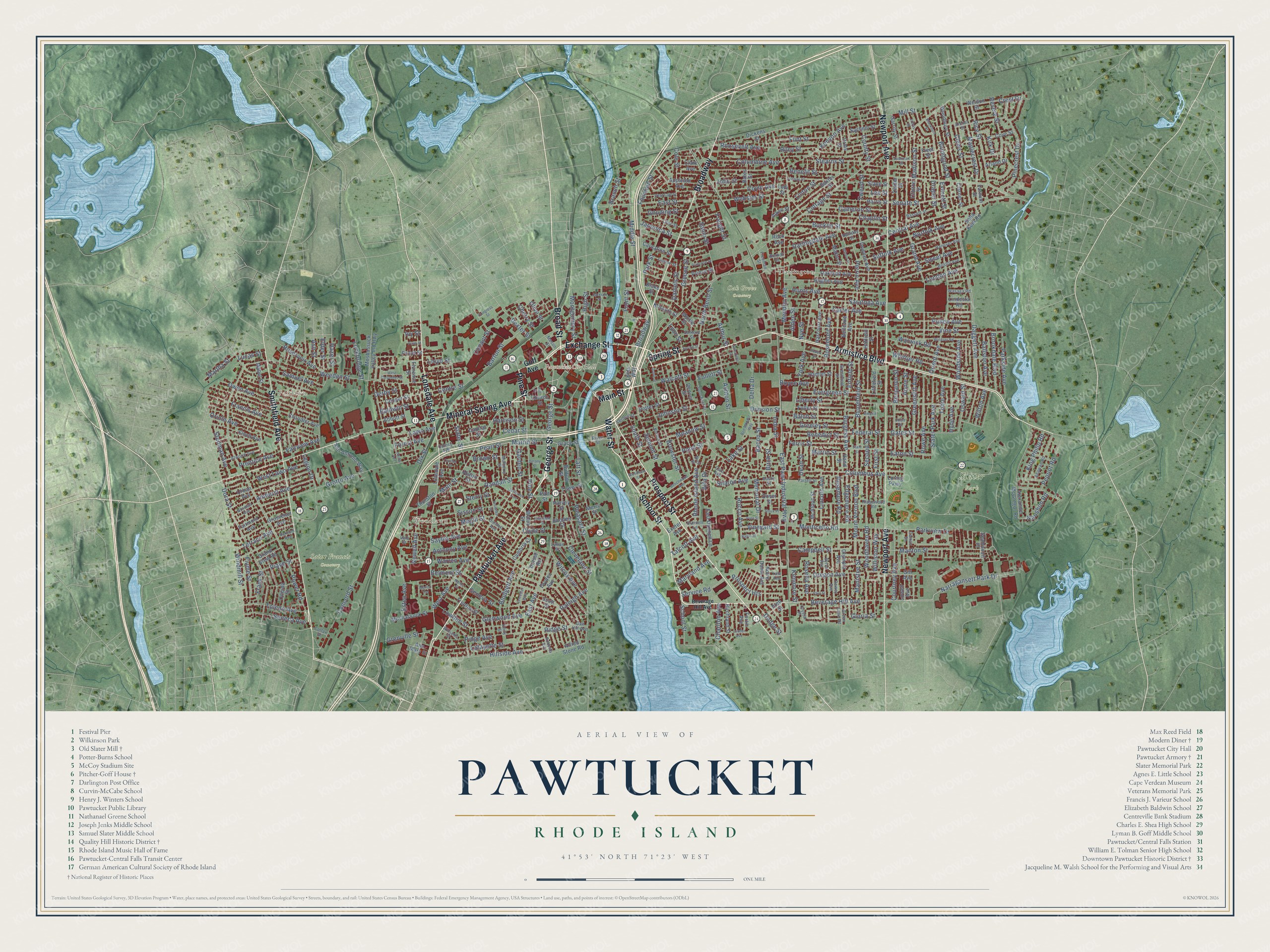
Pawtucket, Rhode Island Map Art
Building by building, with labeled streets and shaded relief.
12" x 18" Archival Matte Print
A Map of Home. A Work of Art.
Explore Pawtucket, Rhode Island from a whole new perspective. Created using aerial imagery and detailed geographic data, this map captures Pawtucket building by building, with labeled streets, familiar landmarks, and shaded topographical relief that highlights the natural contours of the landscape.
Combining modern data with the timeless character of a vintage atlas, this map is just as interesting up close as it is beautiful on the wall. Whether you grew up in Pawtucket, spent memorable years there, or call it home today, this unique map is a great way to celebrate a place that means something to you. Zoom in on the preview to look for your street, and then order a print to put your memories on the wall.
Three ways to hang it

Unframed archival matte, a black wood frame or a white wood frame.
Up close
Geography Worth Displaying
This map was created using accurate cartographic data and authoritative geographic sources, including the U.S. Geological Survey (USGS) and FEMA. The map brings together terrain, waterways, roads, and building detail. The majority of the streets are labeled, houses are accurately depicted, and the topography is derived from government sources. Combining local data with carefully composed color and shading leads to this beautifully detailed Pawtucket artwork for your wall.
Rather than simply showing street outlines, we’ve included as many of the street names as we could reasonably fit on the map while keeping their names legible. Zoom in on the high resolution preview to see exactly what’s on the map. We truly set out to create a statement piece for anyone who loves Pawtucket. So whether it’s for you, or a gift for someone you love, we hope this map of Pawtucket brings back fond memories.
Explore the full map of Pawtucket, Rhode Island and read about the local places it shows.

Find your street
Names on the Pawtucket map
Every name below is printed on this map. Look for your street, your school, the park where you played, or the pond down the road.
Places and landmarks7
- Pawtucket City Hall
- Fairlawn
- Woodlawn
- Oak Grove Cemetery
- Saint Francis Cemetery
- Slater Park
- Darlington
Streets and roads414
- Pawtucket Avenue
- George Street
- Main Street
- Broad Street
- Water Street
- School Street
- Broadway
- Spring Street
- Armistice Boulevard
- Pine Street
- Exchange Street
- Newport Avenue
- Smithfield Avenue
- Mineral Spring Avenue
- Prospect Street
- Lonsdale Avenue
- East Avenue
- Beverage Hill Avenue
- Narragansett Park Drive
- Dexter Street
- Marrin Street
- Daggett Avenue
- North Bend Street
- Pearl Street
- Frank Street
- Central Avenue
- Taft Street
- London Avenue
- Roosevelt Avenue
- East Pawt Industrial Highway
Show all 414 streets
- Cottage Street
- York Avenue
- Benefit Street
- Power Road
- Weeden Street
- Pleasant Street
- Division Street
- Walcott Street
- Kenyon Avenue
- West Avenue
- Grand Avenue
- Mendon Avenue
- Fountain Street
- Carter Avenue
- Columbus Avenue
- Grotto Avenue
- Vine Street
- Glenwood Avenue
- Orient Avenue
- Middle Street
- Saratoga Avenue
- Woodhaven Road
- Garden Street
- Sayles Avenue
- Parkview Drive
- Barton Street
- Webster Street
- Harrison Street
- Lowden Street
- Francis Avenue
- Williston Way
- Bloomfield Street
- Rhode Island Avenue
- Lafayette Street
- Pullen Avenue
- Hunts Avenue
- Perrin Avenue
- Randall Street
- Japonica Street
- Monticello Road
- Owen Avenue
- Pinecrest Drive
- Manton Street
- Dora Street
- Coyle Avenue
- Conant Street
- Newell Avenue
- Norfolk Avenue
- East Street
- Suffolk Avenue
- Bucklin Street
- Cleveland Street
- Whittier Road
- Legion Drive
- Liberty Street
- Sterry Street
- High Street
- Meadow Street
- Sisson Street
- Evergreen Street
- Esten Avenue
- Benjamin Street
- Warren Avenue
- Raleigh Avenue
- Pond Street
- Rice Street
- Concord Street
- Rowe Avenue
- Pidge Avenue
- Maplecrest Drive
- Chaplin Street
- Brewster Street
- Greenslitt Avenue
- Front Street
- Mount Vernon Boulevard
- Sabin Street
- Slater Park Avenue
- Magill Street
- Burgess Avenue
- Sweet Avenue
- Rosemere Road
- Summit Street
- John Street
- Darlingdale Avenue
- Park Street
- Columbine Avenue
- Cameron Street
- Naushon Road
- Oriole Avenue
- Senate Street
- Gates Street
- Courtney Avenue
- Bloodgood Street
- Samuel Avenue
- First Street
- Campbell Street
- Oregon Avenue
- Stearns Street
- Edgemere Road
- Tweed Street
- Parkside Avenue
- Terrace Avenue
- Warwick Road
- Johnson Street
- Revere Street
- Anthony Avenue
- Seneca Avenue
- Hillside Avenue
- Memorial Drive
- Ashton Street
- Second Street
- Cedar Street
- Benedict Street
- Toledo Avenue
- Piave Street
- West Lawn Avenue
- Balch Street
- Bacon Street
- Freight Street
- Clews Street
- Amherst Avenue
- Crest Drive
- Brown Street
- Brookdale Boulevard
- Montgomery Street
- Ferris Street
- Annie Street
- Reservoir Avenue
- Stedman Avenue
- Flint Street
- Lincoln Avenue
- Sharon Avenue
- Ballston Avenue
- Tobie Avenue
- Cole Street
- Greeley Street
- Clyde Street
- Rosemont Avenue
- Lee Street
- Ridge Street
- King Philip Road
- Slater Street
- Hyde Avenue
- Greene Street
- Baldwin Street
- Wilcox Avenue
- Madison Street
- Branch Street
- Lake Street
- Grenville Street
- Blodgett Avenue
- Oswald Street
- Rocco Avenue
- Gooding Street
- Alfa Drive
- Delta Drive
- Service Road
- County Street
- Belmont Street
- Prospect Heights
- Eaton Street
- Centre Street
- Manistee Street
- Windmill Street
- Prentice Avenue
- Arthur Street
- Pequot Road
- India Street
- Lawn Avenue
- Mill Street
- Fiume Street
- Woodside Avenue
- Daniels Street
- Rosella Avenue
- Lockbridge Street
- Maryland Avenue
- Fairview Avenue
- Riley Street
- Charlton Avenue
- Gloria Street
- Dodge Street
- Martha Street
- Federal Street
- Hazel Street
- Enfield Street
- Dix Street
- Vineyard Street
- Draper Street
- Wilton Avenue
- Dean Street
- Forest Avenue
- Linton Street
- Talcott Avenue
- Geneva Street
- Martin Street
- Boyce Avenue
- Everett Street
- Elder Street
- Kenmore Street
- South Street
- Nye Street
- Kirk Drive
- Alden Street
- Birch Street
- Cherry Street
- Lucas Street
- Lloyd Street
- Derby Street
- Lyon Street
- Ash Street
- Follett Street
- Olive Street
- Ivy Street
- Goff Avenue
- Thurston Street
- Chandler Avenue
- Oakland Avenue
- Hughes Avenue
- Alexander McGregor Road
- Baxter Street
- Trenton Street
- Fuller Street
- Grace Street
- Grosvenor Avenue
- Arland Drive
- Littlefield Street
- Harris Street
- Hatfield Street
- Oneida Street
- Woodbury Street
- Cambria Court
- Carnation Street
- Seabiscuit Place
- Rock Avenue
- Calder Street
- Hamlet Street
- Olympia Avenue
- Finch Avenue
- Moshassuck Valley Ind Highway
- Capital Street
- Dryden Avenue
- Appleton Avenue
- Denver Street
- Dickens Street
- Notre Dame Avenue
- Moshassuck Street
- Slade Street
- Bates Street
- Cooper Street
- San Antonio Way
- Downes Avenue
- Bellevue Avenue
- Dover Street
- East Dunnell Lane
- Loring Parkway
- Alfred Stone Road
- McAloon Street
- Seba Kent Road
- Potter Street
- Harcourt Avenue
- Sachem Street
- Abbott Street
- Gill Avenue
- Exeter Avenue
- Ann Mary Street
- Makin Street
- Clark Avenue
- Fred Street
- Weldon Street
- Birchland Street
- Fortin Avenue
- Prince Street
- Fairmont Avenue
- Hilton Street
- Tower Street
- Grand View Road
- Urban Avenue
- Kossuth Street
- Rhodes Street
- Garrity Street
- Clarner Street
- Buffum Street
- Cove Street
- Lowell Avenue
- Church Street
- Waldo Street
- Orms Street
- Myrtle Street
- Scott Street
- Mabel Street
- Clinton Street
- Lindesta Road
- Blake Street
- Merry Street
- Harvey Street
- Kids Way
- Florence Street
- Patt Street
- Privet Street
- Farnum Street
- Aiken Street
- Hand Street
- Dorset Road
- Fleet Street
- Lodi Street
- Hanover Avenue
- Dunnell Avenue
- Bristol Avenue
- Oak Hill Avenue
- Ridgewood Road
- Mulberry Street
- Byron Avenue
- Dewey Avenue
- Archer Street
- Anawan Road
- Varnum Avenue
- Arch Street
- Atwood Avenue
- Quincy Avenue
- Lyman Street
- Norton Street
- Vale Street
- Bassett Street
- Greenfield Street
- Norman Avenue
- Lilac Street
- Lupine Street
- Unity Street
- Dunnell Lane
- Vernon Street
- Farrell Street
- Green Lane Road
- Roberta Avenue
- Wasaga Road
- Cato Avenue
- Sanford Street
- Camac Street
- Freeman Street
- River Street
- Crystal Place
- Williams Street
- Busby Street
- Mason Street
- Yale Avenue
- Halliday Street
- Berndt Street
- Colfax Street
- Joan Drive
- South Bend Street
- Blackburn Street
- Windsor Road
- West Carpenter Street
- Beechwood Avenue
- Ordway Street
- Knowles Street
- State Street
- Jefferson Avenue
- Hurley Avenue
- West Cole Street
- Jackson Street
- Cushman Street
- Ben Mondor Way
- Empire Street
- Paul Street
- Lauder Avenue
- Primrose Street
- Highland Street
- Robert Street
- Grove Street
- Wilson Street
- Woodland Street
- Nancy Street
- Jutras Street
- Leicester Way
- Balbo Street
- Congress Street
- Polo Street
- Delany Street
- Schofield Street
- Carson Street
- Sioux Place
- Palm Street
- Marion Terrace
- Hill Street
Names are listed as they appear on the printed map. Zoom into the product photos to find them.
About Pawtucket, Rhode Island
Pawtucket is a city of 75,604 people in Providence County, the fourth-largest in Rhode Island. Its name is an Algonquian word meaning "river fall," and Native people fished for salmon at the falls of the Blackstone River long before Europeans arrived. In 1671 Joseph Jenckes Jr. of Lynn, Massachusetts, bought about 60 acres by the falls and built a sawmill and a forge, but King Philip's War wiped out the settlement.
Settlers came back, and by 1775 they were making muskets, ships, potash and linseed oil, while Oziel Wilkinson's family forged anchors, nails and cannons. For generations the river divided the place, with North Providence holding the west bank and Rehoboth, Massachusetts, the east. In 1828 the east bank was split off from Rehoboth as a new Massachusetts town. A boundary fight that had run about 225 years ended on March 1, 1862, when that town moved into Rhode Island. The west bank joined it in 1874, though the two halves still acted like separate towns until they merged as one city in 1886.
- Slater's mill of 1793Samuel Slater trained as an apprentice in Belper, England, then sailed across the Atlantic. Moses Brown of Providence gave him the job of building machines that used water power to spin cotton yarn. Slater finished the machines, dam, waterwheel and mill in 1793, making it America's first water-powered cotton spinning mill on Richard Arkwright's system. The mill opened as a museum in 1955, and the National Park Service took it over in 2021.
- America's first factory strikeAfter hard years for textiles in the early 1820s, mill owners made the workday longer and cut pay for the power-loom weavers, all women from 15 to 30. In May 1824 about one hundred of them walked out and shut the mills. Others joined, and the strike ran from May 26 to June 3, ending in a compromise. It sparked labor organizing and more strikes across the region.
- A mill owner's houseThe Pitcher-Goff House on Walcott Street went up in 1840 for Elias B. Pitcher, a cotton manufacturer. In 1881 the industrialist Lyman B. Goff added Queen Anne woodwork inside. The house was later used by the Red Cross and then the Boy Scouts, and in 1970 the Rhode Island Children's Museum opened there in its first home. It joined the National Register in 1976.
- 33 innings in 1981The Pawtucket Red Sox, the Boston Red Sox's Triple-A team, played at McCoy Stadium from 1970 to 2020. In 1981 they beat Rochester there in a 33-inning game, the longest in professional baseball, and both Cal Ripken Jr. and Wade Boggs played in it. The team moved to Worcester, Massachusetts, for the 2021 season, and crews began tearing down McCoy in 2025.
Keep exploring Rhode Island
Pawtucket is one of 86 Rhode Island towns we've mapped. Every dot on the map is a print of its own.
The search covers every state, Rhode Island first.
Near Pawtucket
Order 2 or more town maps and save 10%. Shown in the size and finish you picked above, so they hang as a set.
- Central Falls 12" x 18" / Archival Matte Print $39.99
- Saylesville 12" x 18" / Archival Matte Print $39.99
- Lonsdale 12" x 18" / Archival Matte Print $39.99


More maps nearby: Valley Falls, Wanskuck, Providence, North Providence and Federal Hill.
The art of mapping a place
How This Map Was Made
Real places. Remarkable detail. Discover the layers that turn geographic data into a map of home.

The view from above
Aerial imagery reveals the character of the land: woodland, open fields, and the patterns of a place.

The shape of the land
Elevation data brings hills, valleys, and subtle changes in the landscape into view.

The details of home
Roads, waterways, and building footprints come together to make the map feel unmistakably local.

Geography becomes art
Considered color, shading, and typography bring the layers together in a map made for your wall.


Process illustrated with Mendon, Massachusetts. Aerial imagery: USDA NAIP. Terrain: USGS 3D Elevation Program. Map details and finished artwork: KNOWOL.
The Details
About This Print
Choose an archival matte print, or a black or white Ayous wood frame. The archival matte print is unframed.
Select your size and finish above to see the matching product image and price.
Materials & Craftsmanship
A contemporary map with the character of a classic atlas, printed on archival matte paper. Optional frames are made from Ayous wood.
Your printed map does not include the watermark shown in the full-map preview.
Shipping & Delivery
Free shipping within the United States. Every print is made to order in the USA.
Buying a gift? Add a note in your cart and we'll include it. We never put prices in the package.
Prints ship within 2 to 3 business days. Allow 7 to 10 days total from ordering for delivery. Timing may vary during holidays or periods of high order volume.
Read our shipping policy.
Returns and damaged prints
Each print is made to order. Change-of-mind refunds are not available after production.
If your print arrives damaged, misprinted or incorrect, contact support@knowol.com within 30 days of receiving it. Include your order number, photos and a description of the issue.
Read our full refund and replacement policy. For questions about your order, email support@knowol.com.