
Search for another town





Free U.S. delivery 7 to 10 days after you order
Frisco, Texas Map Art
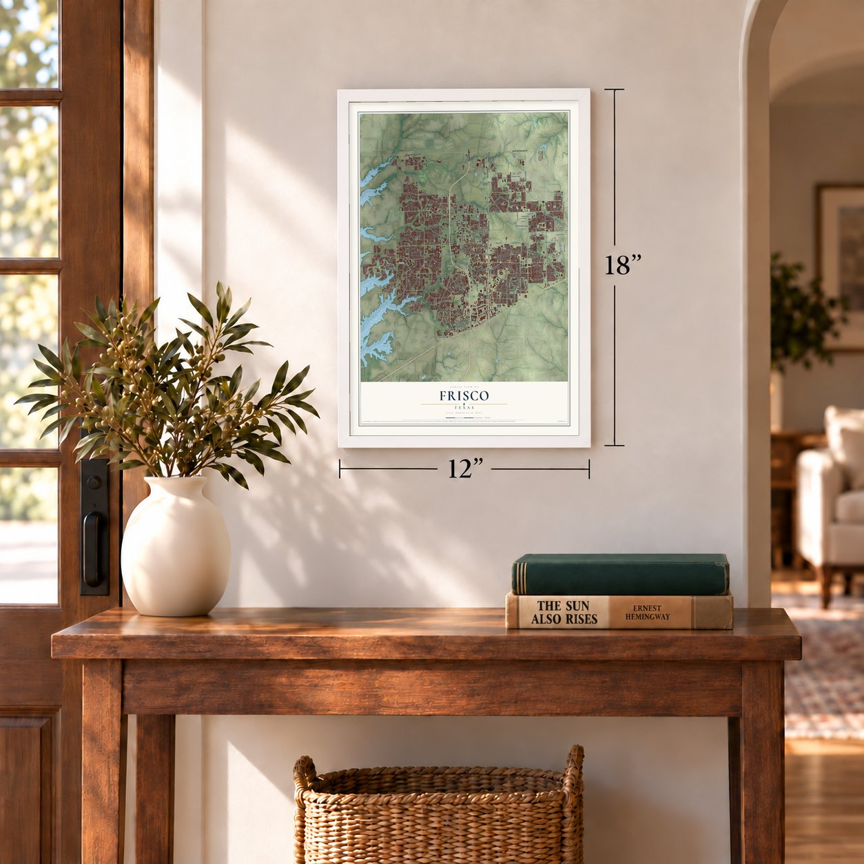
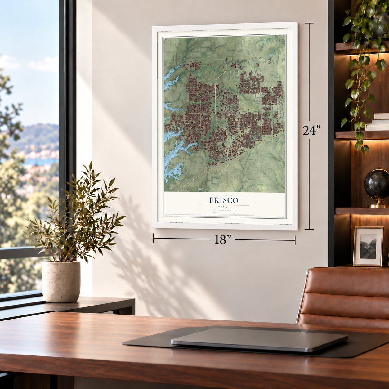
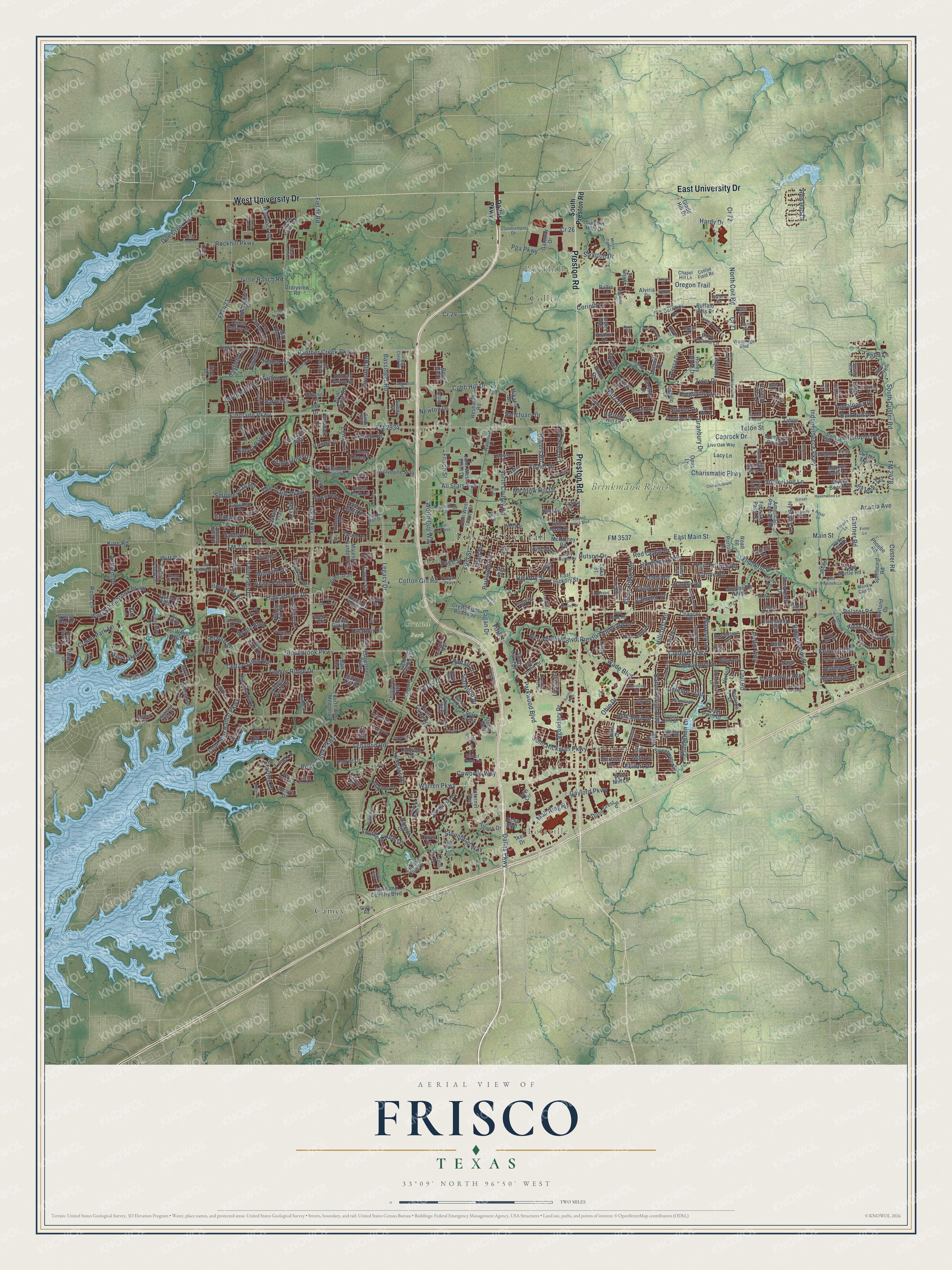
A new map of Frisco, Texas, made in 2026 and printed to order on thick archival matte paper.
12" x 18" Archival Matte Print
A Map of Home. A Work of Art.
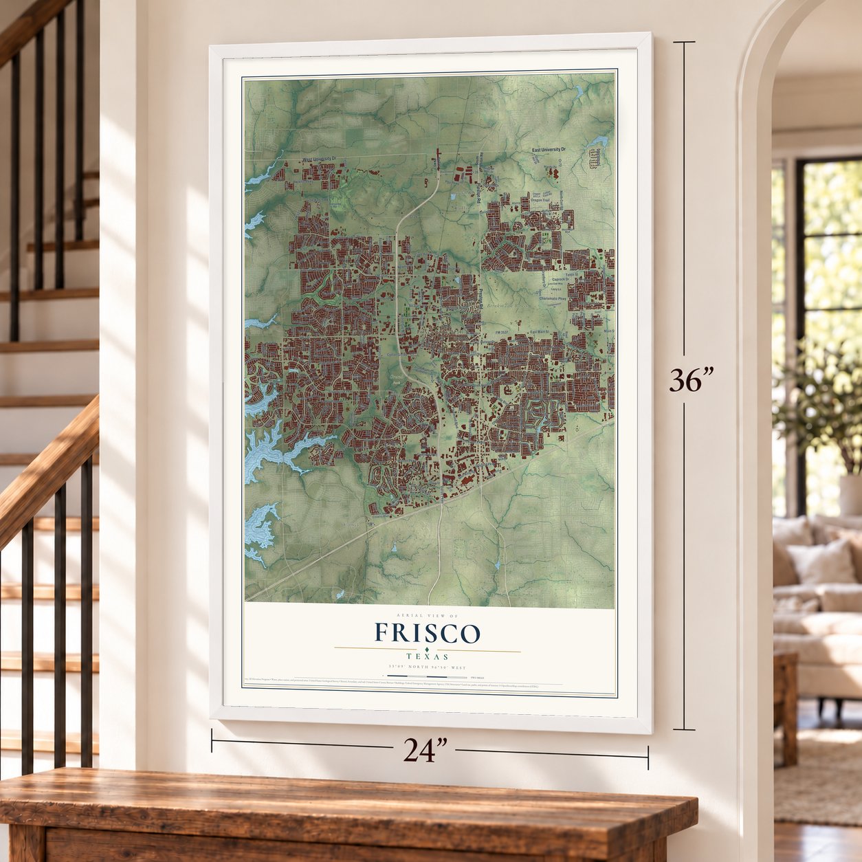
This beautifully detailed map of Frisco, Texas was created in 2026 using aerial imagery combined with modern topographical, census, street and landmark data. It's a modern aerial view of Frisco in Collin County, Texas, that combines modern data with a vintage aesthetic. Zoom in on the preview and look for your block.
Three ways to hang it
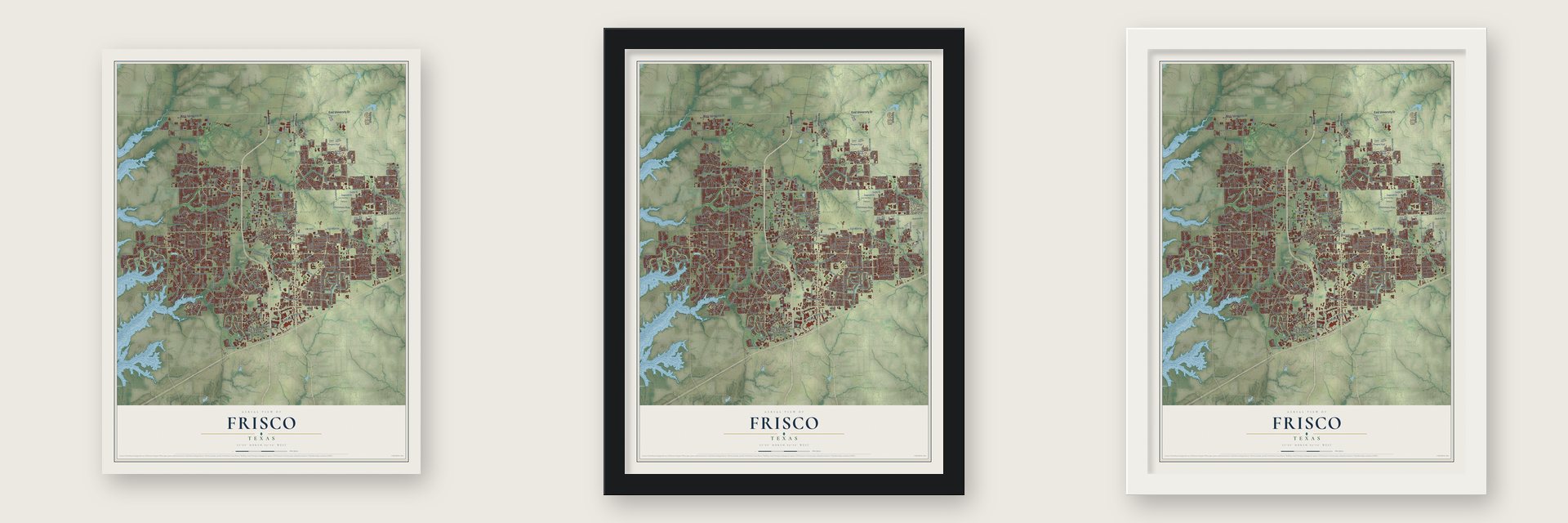
Unframed archival matte, a black wood frame or a white wood frame.
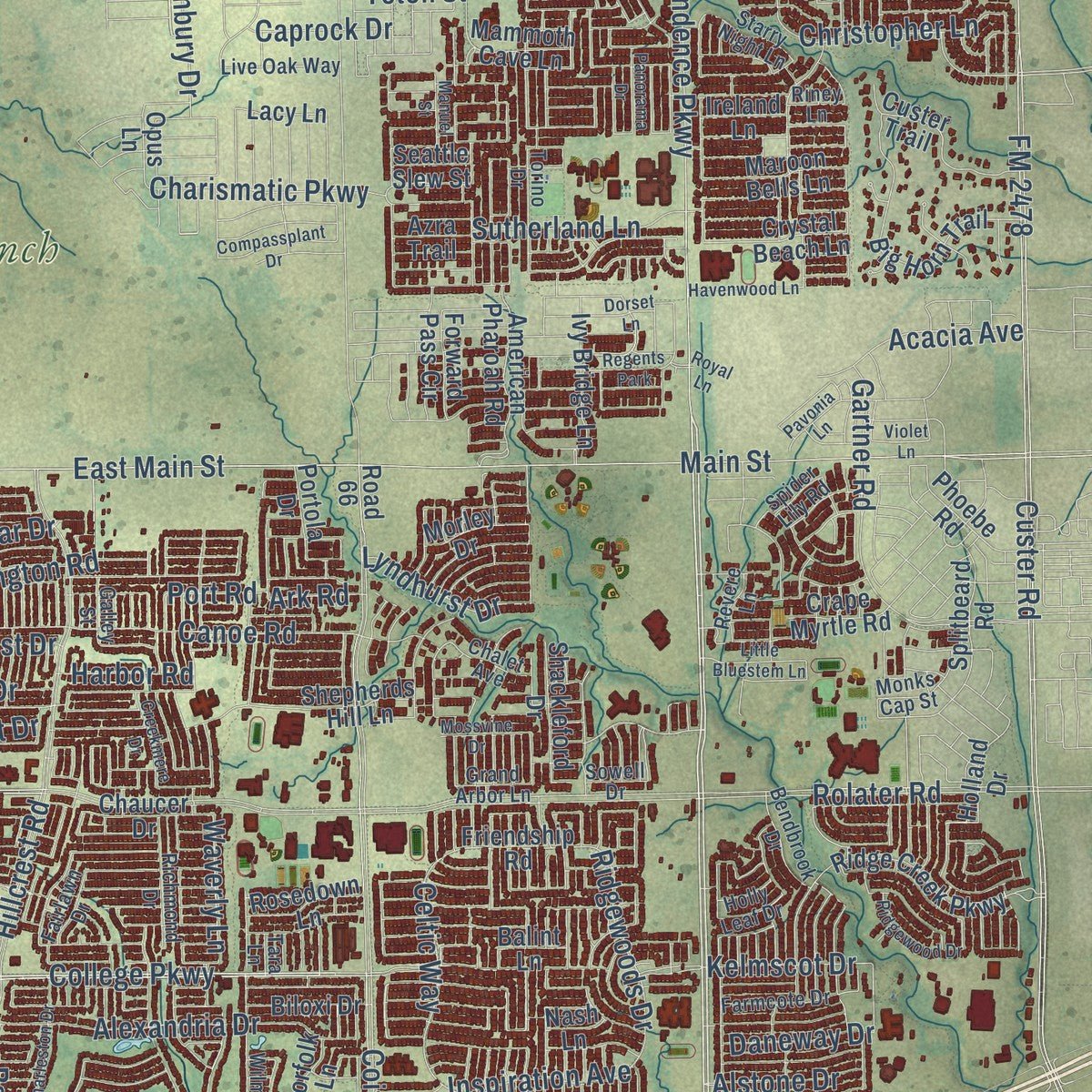
Up close
Real geography. Art worth displaying.
This map was created using accurate cartographic data and authoritative geographic sources, including the U.S. Geological Survey and the Census Bureau. The map brings together terrain, waterways, roads, and building detail. The majority of the streets are labeled, houses are accurately depicted, and the topography is derived from government sources. Combining local data with carefully composed color and shading leads to this beautifully detailed Frisco artwork for your wall.
Rather than simply showing street outlines, we’ve included as many of the street names as we could reasonably fit on the map while keeping their names legible. Zoom in on the high resolution preview to see exactly what’s on the map. We truly set out to create a statement piece for anyone who loves Frisco. So whether it’s for you, or a gift for someone you love, we hope this map of Frisco brings back fond memories.
About Frisco, Texas
Frisco occupies portions of Collin and Denton counties within the Dallas Fort Worth metroplex. The 2020 census counted 200,509 residents. Its history encompasses a railway settlement, an agricultural shipping center, and later suburban growth associated with Dallas and Plano.
- From Emerson to FriscoThe settlement was first named Emerson, then became Frisco City in honor of the St. Louis, San Francisco and Texas Railway before its name was shortened.
- Railroad BeginningsFrisco incorporated in the early twentieth century as people from nearby Erudia and Lebanon relocated to benefit from the railroad.
- Farm Trade CenterEarly Frisco served farmers through retail and shipping, with cotton gins, grain elevators, and a Farmers Co-operative Gin Association.
- Population GrowthPopulation figures rose from 618 in 1930 to 1,184 in 1960, 33,714 in 2000, and 200,509 in 2020.
- Sporting HomesFC Dallas and the Frisco RoughRiders play in Frisco, while the Dallas Cowboys maintain their headquarters and training facilities at The Star.
Find your street
Names on the Frisco map
Every name below is printed on this map. Look for your street, your school, the park where you played, or the pond down the road.
Places and landmarks9
- Frisco City Hall
- Rockhill
- Lolaville
- Brinkmann Ranch
- Grand Park
- Camey
- Collin
- Lebanon
- Regents Park
Streets and roads471
- Preston Road
- West University Drive
- East University Drive
- Dallas Parkway
- Legacy Drive
- Independence Parkway
- Warren Parkway
- College Parkway
- Starling Drive
- Lilac Lane
- Lebanon Road
- Eldorado Parkway
- Main Street
- Teel Parkway
- Stonebrook Parkway
- Hillcrest Road
- FM 423
- Panther Creek Parkway
- Rolater Road
- Ohio Drive
- Parkwood Boulevard
- Coit Road
- Gaylord Parkway
- FM 2934
- FM 3537
- FM 2478
- Frisco Street
- Pga Parkway
- Custer Road
- Lone Star Ranch Parkway
Show all 471 streets
- Wade Boulevard
- East Main Street
- Cotton Gin Road
- West Stonebrook Parkway
- North County Road
- Cr 24
- Frisco Lakes Drive
- Bassinger Road
- Parkwood Drive
- Southern Hills Drive
- Plantation Lane
- Starwood Drive
- Gartner Road
- The Trails Parkway
- Rockhill Parkway
- Stonebriar Way
- Hickory Street
- John Hickman Parkway
- Rock Creek Parkway
- North Coit Road
- Canoe Road
- Mall Ring Road
- Fifth Street
- Timber Ridge Drive
- Preston Vineyard Drive
- World Cup Way
- South Custer Road
- Hutson Drive
- Meadow Hill Drive
- Angel Falls Drive
- Jereme Trail
- Anthem Drive
- Cedar Ranch Road
- High Shoals Drive
- Alexandria Drive
- Witt Road
- Kings Ridge Road
- Fisher Drive
- Cr 72
- Rogers Road
- Cobb Hill Drive
- Cr 71
- Texas Drive
- Legendary Drive
- Kelmscot Drive
- Christopher Lane
- First Street
- Baton Rouge Boulevard
- Huntington Road
- All Stars Avenue
- Brookhollow Boulevard
- FM 720
- Doe Creek Road
- Smotherman Road
- Charismatic Parkway
- Red Cedar Drive
- King Road
- Riverhill Road
- Inspiration Avenue
- Sutherland Lane
- Citation Court
- Camelot Drive
- Cr 26
- Little Ranch Road
- Twin Falls Drive
- Ridgewoods Drive
- Asheboro Drive
- Acacia Avenue
- Blackstone Drive
- Canal Street
- Swan Lake Drive
- Lenox Lane
- Echols Drive
- Cowboys Way
- Castle Drive
- Granbury Drive
- Sanctuary Drive
- Veneto Drive
- Buena Park Drive
- Compass Drive
- Celtic Way
- Lyndhurst Drive
- Crown Park Lane
- Idlewild Drive
- Alstone Drive
- Page Street
- Appaloosa Drive
- Quest Drive
- Stratton Drive
- Snyder Drive
- Eagan Drive
- Corinth Lane
- Bayfield Drive
- Bull Run Drive
- Plum Lane
- Red Bud Drive
- Oregon Trail
- Third Street
- Kingsville Drive
- Daneway Drive
- Tyler Drive
- Bridle Boulevard
- Waverly Lane
- Talley Lane
- Caprock Drive
- Barret Drive
- Fields Road
- Blitz Drive
- Harbor Road
- Hardy Drive
- Newton Drive
- Rose Lane
- Pintail Lane
- Max Lane
- Jaguar Drive
- Talbot Drive
- Belfort Drive
- Teton Street
- Liam Drive
- Ark Road
- Port Road
- Lesli Lane
- South Preston Road
- South Texas Drive
- Alcove Drive
- Ironwood Drive
- Cheryl Drive
- Brett Drive
- Town and Country Boulevard
- Stonebriar Drive
- Research Road
- East Hickory Street
- Majestic Gardens Drive
- McKinney Road
- Big Horn Trail
- John West Elliott Drive
- Del Webb Boulevard
- Oakland Hills Lane
- Ridge Creek Parkway
- American Pharoah Road
- Kirby Lane
- Splitbeard Road
- Stone Crest Road
- Country Club Drive
- Ikea Drive
- Beacon Hill Drive
- Cr 710
- Custer Trail
- Fourth Army Memorial
- Hidden Creek Lane
- Avalon Way
- Ash Street
- Internet Boulevard
- Crape Myrtle Road
- Friendship Road
- Mammoth Cave Lane
- Hollyhock Road
- Pasatiempo Drive
- John West Elliot Drive
- Fall Harvest Drive
- Dutch Hollow Drive
- Longvue Drive
- Crystallizer Roadway
- Bonneville Road
- Glade Hill Drive
- Speargrass Drive
- Wolverine Way
- Hickory Grove Lane
- Burnt Prairie Lane
- Shepherds Hill Lane
- Oyster Bay Drive
- Diamond Point Lane
- Coralberry Drive
- Shaddock Creek Lane
- Honey Grove Drive
- Mikaela Drive
- Shingle Mill Road
- Shady Oaks Drive
- Sweetwater Drive
- Ivy Bridge Lane
- Access Drive
- Cherry Ridge Drive
- Edgestone Parkway
- Overhill Drive
- Phoebe Road
- Maroon Bells Lane
- Crystal Beach Lane
- Barkwood Lane
- Robertson Drive
- Shackleford Drive
- Summit Hills Drive
- Guinn Gate Drive
- Deerwood Lane
- Rawlins Lane
- Golfside Drive
- Gloryview Road
- Chaucer Drive
- Gladewater Drive
- Fighting Eagles Lane
- Colby Drive
- Dubai Way
- Augusta Drive
- La Mesa Drive
- Biloxi Drive
- Santa Fe Trail
- Rosedown Lane
- Del Largo Way
- Creek Point Drive
- Bugatti Drive
- Mariner Drive
- Briar Ridge Road
- River Trail
- Mill Town Drive
- Odessa Drive
- Grist Mill Lane
- Hillside Drive
- Holland Drive
- Palace Place
- Crockett Drive
- Forward Pass Circle
- Cerrillos Drive
- Foard Drive
- Gateway Drive
- Creek Plum Road
- Holly Street
- Patriot Drive
- Chippewa Trail
- Cotton Patch Lane
- Morley Drive
- Norfolk Lane
- Chevy Chase Lane
- Buffalo Hills Drive
- Latigo Drive
- Eastpark Lane
- Bancroft Lane
- Oak Point Drive
- Jennifer Lane
- Portola Drive
- Seei Circle
- Michelle Drive
- Carriage Hill Lane
- Hicks Boulevard
- Alviria Drive
- Forest Park Lane
- Paragon Drive
- Lacy Lane
- Godfrey Drive
- Shirland Lane
- Kent Drive
- Peace River Drive
- Marble Hill Road
- Sunny Street
- Taylor Way
- Ireland Lane
- Santa Rosa Drive
- Avalon Drive
- Angelo Drive
- Road 66
- Opus Lane
- Tahoe Lane
- Azra Trail
- Seattle Slew Street
- Viola Drive
- Platt Drive
- Nation Drive
- Loxley Drive
- Belle Isle Lane
- Joy Drive
- Roma Drive
- Galaxy Drive
- Gillon Drive
- Lazio Lane
- Balint Lane
- Travis Drive
- Frio Way
- Star Creek
- Miles Drive
- Baltic Lane
- Nash Lane
- Lucy Lane
- Sitka Street
- Ida Drive
- Hall Road
- Kite Lane
- Salt Grass Lane
- Fisher Road
- Promise Land Drive
- Longwood Drive
- Technology Drive
- Westridge Boulevard
- Napa Valley Drive
- Wilmington Drive
- Biltmoore Drive
- Oak Street
- Corsicana Drive
- Chalk Bluff Drive
- Farmcote Drive
- Richmond Drive
- Pelican Drive
- Torino Drive
- Lightfoot Lane
- Live Oak Way
- Bethel Drive
- Commitment Drive
- Bendbrook Drive
- Dowelling Drive
- Old Newman Road
- Hermitage Lane
- Gary Burns Drive
- Monks Cap Street
- Starry Night Lane
- Cliff Trail
- Osage Place
- King Arthur Road
- Cimarron Road
- Mission Avenue
- Myrtle Lane
- Reynolds Lane
- Waterfall Lane
- Crest Pointe Place
- Chalet Avenue
- Turnberry Drive
- Park Ridge Drive
- Cotton Field Road
- Bell Rock Road
- Haley Way
- Longhorn Trail
- Spring Lake Road
- Carnegie Drive
- North Street
- Prospect Drive
- Highland Hills Drive
- Hall of Fame Lane
- Coleto Creek Drive
- Edgecliff Drive
- Chapel Hill Lane
- Fairlawn Drive
- Sara Drive
- Coon Lane
- Pomona Lane
- Grand Arbor Lane
- Settlers Drive
- Bay Hill Drive
- Revere Lane
- Autumn Glen Drive
- Holly Leaf Drive
- Fayette Trail
- Trail View Lane
- Teresa Lane
- Galley Street
- Throne Hall Drive
- Bois D' Arc Lane
- Spring Hill Drive
- Del Rio Drive
- Sowell Drive
- Sand Hill Drive
- Spider Lily Road
- Titus Lane
- Llano Avenue
- Griffin Road
- Riney Lane
- Villita Street
- Lariat Trail
- Tara Lane
- Grosseto Drive
- South Fifth Street
- Platinum Parkway
- Preston North Drive
- Savannah Ridge Drive
- Preston Trace Boulevard
- Harbor Springs Drive
- Charleston Drive
- McGregor Drive
- Rio Grande Drive
- Orchard Park Drive
- Whispering Lake Drive
- Daimler Drive
- Frisco Green Avenue
- Round Prairie Lane
- Compassplant Drive
- Mossy Oak Lane
- Wildfire Lane
- Havenwood Lane
- John Wesley Drive
- Ridgewood Drive
- Yellowstone Drive
- Dorset Lane
- Glademeadow Drive
- Stallion Ranch Road
- Munira Drive
- Fernando Road
- Lamar Hunt Way
- Little Bluestem Lane
- Hilton Head Lane
- Creekmere Drive
- Snowberry Drive
- Promontory Drive
- Pavonia Lane
- Sandstone Drive
- Pinnacle Drive
- Mossvine Drive
- Wyoming Drive
- Cool Meadow Drive
- Spanish Oaks Drive
- Crestline Circle
- Winding Creek Drive
- Panorama Drive
- Country Glen Trail
- Tate Lane
- Camfield Way Street
- Surrey Path
- Villanova Drive
- Shamrock Drive
- Hemlock Trail
- Cecil Drive
- Tambra Drive
- Doonan Crossing
- Manuel Street
- Little River Drive
- Lorna Doone Lane
- Frisco Road
- Sleepy Creek Drive
- Timber Creek Lane
- Roaring Fork Lane
- Midwick Drive
- Kettle Creek Drive
- Pleat Leaf Road
- Gavin Drive
- Posada Drive
- Scotch Pine Drive
- Walnut Hill Court
- Curtiss Drive
- Kyser Way
- Violet Lane
- Ortega Street
- Carson Lane
- Leg Iron Drive
- Royal Lane
- Daisy Lane
- Cava Road
- Gem Drive
Names are listed as they appear on the printed map. Zoom into the product photos to find them.
The art of mapping a place
How This Map Was Made
Real places. Remarkable detail. Discover the layers that turn geographic data into a map of home.

The view from above
Aerial imagery reveals the character of the land: woodland, open fields, and the patterns of a place.

The shape of the land
Elevation data brings hills, valleys, and subtle changes in the landscape into view.

The details of home
Roads, waterways, and building footprints come together to make the map feel unmistakably local.

Geography becomes art
Considered color, shading, and typography bring the layers together in a map made for your wall.


Process illustrated with Mendon, Massachusetts. Aerial imagery: USDA NAIP. Terrain: USGS 3D Elevation Program. Map details and finished artwork: KNOWOL.
The Details
About This Print
Choose an archival matte print, or a black or white Ayous wood frame. The archival matte print is unframed.
Select your size and finish above to see the matching product image and price.
Materials & Craftsmanship
A contemporary map with the character of a classic atlas, printed on archival matte paper. Optional frames are made from Ayous wood.
Your printed map does not include the watermark shown in the full-map preview.
Shipping & Delivery
Free shipping within the United States. Every print is made to order in the USA.
Buying a gift? Add a note in your cart and we'll include it. We never put prices in the package.
Prints ship within 2 to 3 business days. Allow 7 to 10 days total from ordering for delivery. Timing may vary during holidays or periods of high order volume.
Read our shipping policy.
Returns and damaged prints
Each print is made to order. Change-of-mind refunds are not available after production.
If your print arrives damaged, misprinted or incorrect, contact support@knowol.com within 30 days of receiving it. Include your order number, photos and a description of the issue.
Read our full refund and replacement policy. For questions about your order, email support@knowol.com.
Find your town
Looking for another city?
Find a map of home in our Texas collection.
Nearby
Maps of towns near Frisco
Know someone from one of these towns? Their map makes a great gift.
 Hackberry
, Texas
From $39.99See the map
 Prosper
, Texas
From $39.99See the map
 Little Elm
, Texas
From $39.99See the map
More maps nearby: The Colony, Savannah, Paloma Creek South, Paloma Creek and Hebron.