
Search for another town


Free U.S. delivery 7 to 10 days after you order
Hanover Hills, Maryland Map Art
Building by building, with labeled streets and shaded relief.
12" x 18" Archival Matte Print
A Map of Home. A Work of Art.
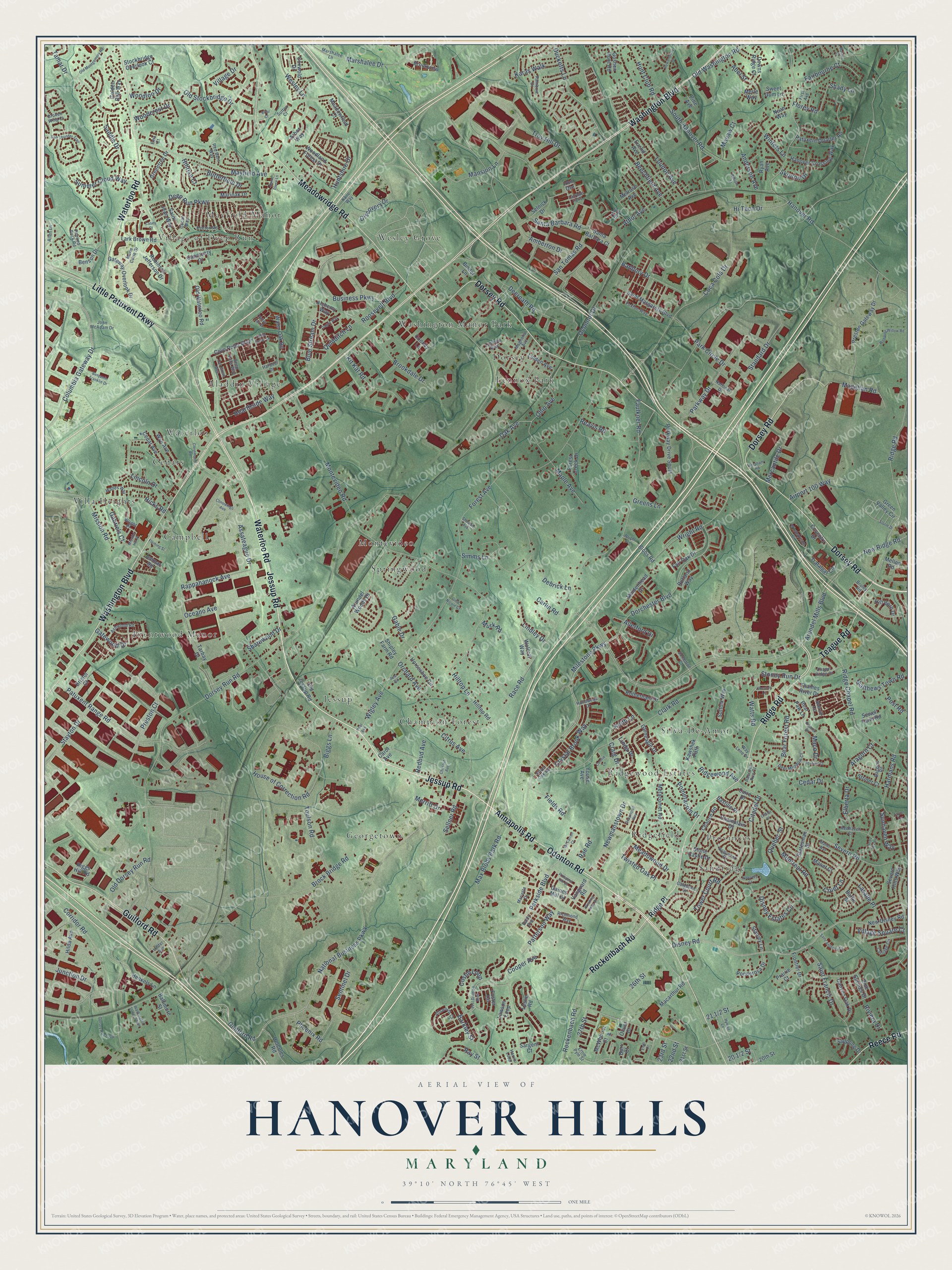
Explore Hanover Hills, Maryland from a whole new perspective. Created using aerial imagery and detailed geographic data, this map captures Hanover Hills building by building, with labeled streets, familiar landmarks, and shaded topographical relief that highlights the natural contours of the landscape.
Combining modern data with the timeless character of a vintage atlas, this map is just as interesting up close as it is beautiful on the wall. Whether you grew up in Hanover Hills, spent memorable years there, or call it home today, this unique map is a great way to celebrate a place that means something to you. Zoom in on the preview to look for your street, and then order a print to put your memories on the wall.
Three ways to hang it

Unframed archival matte, a black wood frame or a white wood frame.
Up close
Geography Worth Displaying
This map was created using accurate cartographic data and authoritative geographic sources, including the U.S. Geological Survey and the Census Bureau. The map brings together terrain, waterways, roads, and building detail. The majority of the streets are labeled, houses are accurately depicted, and the topography is derived from government sources. Combining local data with carefully composed color and shading leads to this beautifully detailed Hanover Hills artwork for your wall.
Rather than simply showing street outlines, we’ve included as many of the street names as we could reasonably fit on the map while keeping their names legible. Zoom in on the high resolution preview to see exactly what’s on the map. We truly set out to create a statement piece for anyone who loves Hanover Hills. So whether it’s for you, or a gift for someone you love, we hope this map of Hanover Hills brings back fond memories.
Read the story behind this map: Detailed Map of Hanover Hills, Maryland.

Find your street
Names on the Hanover Hills map
Every name below is printed on this map. Look for your street, your school, the park where you played, or the pond down the road.
Places and landmarks22
- Silva-De-Amor
- Wesley Grove
- Georgetown
- Waterloo
- Village of Deep Run
- Brentwood Manor
- Sandridge
- Champion Forest
- Campbell
- Springwood
- Lennox Park
- Jessup
Show all 22 places
- Washington Manor Park
- Provinces
- Cedars
- Mayfield Manor
- Aladdin Village
- Ridgefield
- Ridgewood Estates
- Villa Heights
- Dorsey
- Montevideo
Streets and roads365
- Waterloo Road
- Annapolis Road
- Jessup Road
- Guilford Road
- Washington Boulevard
- Dorsey Road
- Little Patuxent Parkway
- Ridge Road
- Meadowridge Road
- Odenton Road
- Rockenbach Road
- Reece Road
- Teague Road
- Ducketts Lane
- National Business Parkway
- Milestone Parkway
- Dorchester Boulevard
- Preston Court
- Disney Road
- Arundel Mills Boulevard
- Wright Road
- Citadel Drive
- Business Parkway
- Park Circle Drive
- Clark Road
- Troy Hill Drive
- Wigley Avenue
- Loudon Avenue
- Race Road
- Dorsey Run Road
Show all 365 streets
- Brock Bridge Road
- Montevideo Road
- Columbia Gateway Drive
- Hanover Road
- House of Correction Road
- Forest Avenue
- Severn Road
- Coca Cola Drive
- Deep Run Parkway
- Parkside Boulevard
- Patuxent Range Road
- Junction Drive
- Simms Lane
- Mayfield Avenue
- Assateague Drive
- Old Stockbridge Drive
- Harmans Road
- Ridge Chapel Road
- Disney Estates Circle
- Wesley Lane
- Ohio Avenue
- Cedar Drive
- Cooper Avenue
- Mission Road
- Corridor Road
- Lasalle Place
- Max Blobs Park Road
- Lincoln Drive
- Montreal Road
- Maple Avenue
- Tamar Drive
- South Hanover Road
- Orchard Avenue
- Stoney Run Drive
- Oceano Avenue
- Parkway Drive
- Hilltop Lane
- Citrus Avenue
- Marshalee Drive
- Standard Drive
- Village Drive
- Saint Francis Drive
- Huntshire Drive
- Bear Forest Road
- Craig Drive
- Crystal Brook Way
- Blue Stream Drive
- 26th Street
- Newmanstown Drive
- Rappahanock Avenue
- Amberton Drive
- Toulson Road
- Banbury Drive
- Sentinel Drive
- Pometacom Drive
- Deerpath Road
- Patterson Way
- Sellner Road
- Meadowood Drive
- Brookdale Drive
- Fairbourne Court
- Stayton Drive
- Magellan Road
- Beechfield Avenue
- Quebec Street
- Saddle Drive
- Kit Kat Road
- Athol Avenue
- Oconnor Drive
- Elberta Drive
- Summer Cloud Way
- Watts Road
- San Tomas Road
- New Ridge Road
- Maco Drive
- Matthews Town Road
- Phoenix Road
- Twisted Oak Place
- Hunt Club Road
- Old Washington Road
- Allerford Drive
- Old Dorsey Run Road
- Roosevelt Boulevard
- Santa Barbara Road
- Hi Tech Drive
- Butterfield Drive
- Mansion Lane
- Redbud Avenue
- Abel Street
- Ridgewood Avenue
- Quidditch Lane
- Discovery Drive
- Woodcrest Drive
- Sharewood Drive
- Gable Drive
- Airport 100 Way
- Tower Court Road
- Barkley Street
- Biggs Lane
- Ray Street
- Village Square Court
- Hearthside Way
- Karas Walk
- Fields Road
- Florey Road
- Mercantile Drive
- Gatewood Drive
- Merritt Drive
- Sunhaven Way
- Lindley Drive
- Oak Avenue
- Macaw Court
- Shady Lane
- Winters Lane
- Aragorn Court
- Hillrise Court
- Faulkner Road
- Linda Place
- 27th Street
- Skipton Drive
- Keith Lane
- Post Road
- Anderson Avenue
- Debrick Lane
- Hicks Road
- Costin Loop
- Gabriels Court
- Greens Lane
- Woodloo Drive
- Cruet Lane
- Riviera Drive
- Rae Road
- Reavis Road
- Carlin Road
- Murk Road
- 23rd Street
- 22nd Street
- Ridge Place
- Old Waterloo Road
- New Disney Road
- Stone Castle Drive
- Cove Point Way
- 21st Street
- Greentree Drive
- Henkels Lane
- Cedar Avenue
- Arundel Woods Drive
- Lark Brown Road
- Preston Gateway Drive
- Old Jessup Road
- Rotherham Drive
- Water Oak Road
- Hilltop Road
- Kawshek Path
- Metacomet Road
- Fair Oak Drive
- Macarthur Road
- Patuxent Quarter Road
- Bastille Place
- Tarbay Drive
- Euclid Avenue
- Parkway Drive South
- Hanover Crossing Way
- Green Valley Circle
- Statesman Street
- Horseshoe Circle
- Gateway Overlook Drive
- Vanguard Road
- Hercules Road
- Trafalgar Circle
- Melrose Avenue
- Chalice Road
- Bear Paw Lane
- Saint Margarets Boulevard
- Linden Avenue
- Woodland Forest Drive
- Cooney Lane
- Foster Circle
- Saint Jean Way
- Canyon Oak Drive
- Alchemy Way
- Robinson Jefferson Drive
- Santa Barbara Court
- Selnick Drive
- Wye Avenue
- Ponderosa Drive
- Maidenhead Drive
- Lawson Loop
- Champlain Drive
- Wolcott Way
- Rutland Way
- Gaines Mill Drive
- Forest Creek Drive
- Hilda Avenue
- McWhorter Court
- Thames River Drive
- Downs Ridge Court
- Meadowfield Court
- Suffolk Way
- Golden Bell Way
- Gleneagle Drive
- Shipley Farm Road
- Burr Court
- Sanctuary Court
- Sappling Drive
- Strider Court
- Oliver Court
- Cuire Drive
- Stockbridge Overlook Court
- Marioak Drive
- Ivy Terrace
- Sewell Farm Road
- 20th Street
- Severn Hills Way
- Brookview
- Hill Born Drive
- Frontier Drive
- Stanley Lane
- Benson Drive
- Coxwold Drive
- Pine Springs Drive
- Goshen Hunt Road
- Coventry Drive
- Pine Avenue
- Blobs Road
- Mellon Road
- Baltimore Street
- Jenmar Road
- Riggs Hill Road
- Bristol Court
- Manet Court
- Arbor Way
- Iron Ore
- Prairie Court
- Sweet Gum Lane
- Ryan Avenue
- Sargent Court
- Youse Avenue
- Binder Lane
- Baffin Street
- Merle Way
- Noah Way
- Carol Avenue
- Leslie Road
- Allsworth Court
- Keeton Road
- Windstream Circle
- Ernie Pyle Street
- Somerton Court
- Huguenot Place
- Deer Meadow Court
- Magnolia Avenue
- Carriage Circle
- Baggins Road
- Marshalee Lane
- Richmond Way
- Allen Lane
- Foxton Way
- Ashwood Road
- Painted Rock Road
- Marie Curie Drive
- Silver Oak Road
- Chapel Ridge Court
- Deep Falls Way
- Rainbow Drive
- Wades Way
- John McAdam Drive
- Harris Loop
- Red Barn Way
- Redhaven Court
- Hollowoak Drive
- Galetown Drive
- Lyndsey Way
- National Drive
- Kane Way
- Raccoon Run Court
- Marietta Drive
- Latrobe Falls
- Hilder Avenue
- Way Lene Drive
- Cocan Way
- Baldy Avenue
- Broken Wing Court
- Harbour Drive
- Sherrill Circle
- First Avenue
- Sutton Court
- Bruley Road
- Wright Place
- Ema Court
- Oak Grove Way
- Manet Way
- 91st Division Boulevard
- Pear Avenue
- Connie Lane
- Cedar Grove Lane
- Old Montgomery Road
- Rowanberry Drive
- Weeping Willow Road
- Crestmount Road
- Dorsey Run Loop
- Soft Thunder Trail
- Cheston Lane
- Saint Anthony Drive
- Winding Hills Drive
- Benjamin Franklin Drive
- Valley Oak Drive
- Foxtrail Court
- McCarron Court
- Dagny Way
- Deepnotch Way
- Chesnut Avenue
- Conowingo Avenue
- Washington Street South
- Fleming Street
- Alderney Court
- Bakers Place
- Hyman Lane
- Urbanik Drive
- Wright Avenue
- Prospect Hill Drive
- Gina Nicole Court
- Abraham Road
- Pear Road
- Mission Hill Place
- Endl Court
- Home Place Lane
- Storm Drive
- Shindale Avenue
- William Street
- Briar Court
- Taylor Terrace
- Chalet Place
- Red Fox Lane
- Casey Court
Names are listed as they appear on the printed map. Zoom into the product photos to find them.
Keep exploring Maryland
Hanover Hills is one of 881 Maryland towns we've mapped. Every dot on the map is a print of its own.
The search covers every state, Maryland first.
Near Hanover Hills
Order 2 or more town maps and save 10%. Shown in the size and finish you picked above, so they hang as a set.
- Jessup 12" x 18" / Archival Matte Print $39.99
- Elkridge 12" x 18" / Archival Matte Print $39.99
- Savage 12" x 18" / Archival Matte Print $39.99


More maps nearby: Severn, Ilchester, Fort Meade, Maryland City and North Laurel.
The art of mapping a place
How This Map Was Made
Real places. Remarkable detail. Discover the layers that turn geographic data into a map of home.

The view from above
Aerial imagery reveals the character of the land: woodland, open fields, and the patterns of a place.

The shape of the land
Elevation data brings hills, valleys, and subtle changes in the landscape into view.

The details of home
Roads, waterways, and building footprints come together to make the map feel unmistakably local.

Geography becomes art
Considered color, shading, and typography bring the layers together in a map made for your wall.


Process illustrated with Mendon, Massachusetts. Aerial imagery: USDA NAIP. Terrain: USGS 3D Elevation Program. Map details and finished artwork: KNOWOL.
The Details
About This Print
Choose an archival matte print, or a black or white Ayous wood frame. The archival matte print is unframed.
Select your size and finish above to see the matching product image and price.
Materials & Craftsmanship
A contemporary map with the character of a classic atlas, printed on archival matte paper. Optional frames are made from Ayous wood.
Your printed map does not include the watermark shown in the full-map preview.
Shipping & Delivery
Free shipping within the United States. Every print is made to order in the USA.
Buying a gift? Add a note in your cart and we'll include it. We never put prices in the package.
Prints ship within 2 to 3 business days. Allow 7 to 10 days total from ordering for delivery. Timing may vary during holidays or periods of high order volume.
Read our shipping policy.
Returns and damaged prints
Each print is made to order. Change-of-mind refunds are not available after production.
If your print arrives damaged, misprinted or incorrect, contact support@knowol.com within 30 days of receiving it. Include your order number, photos and a description of the issue.
Read our full refund and replacement policy. For questions about your order, email support@knowol.com.