
Search for another town


Free U.S. delivery 7 to 10 days after you order
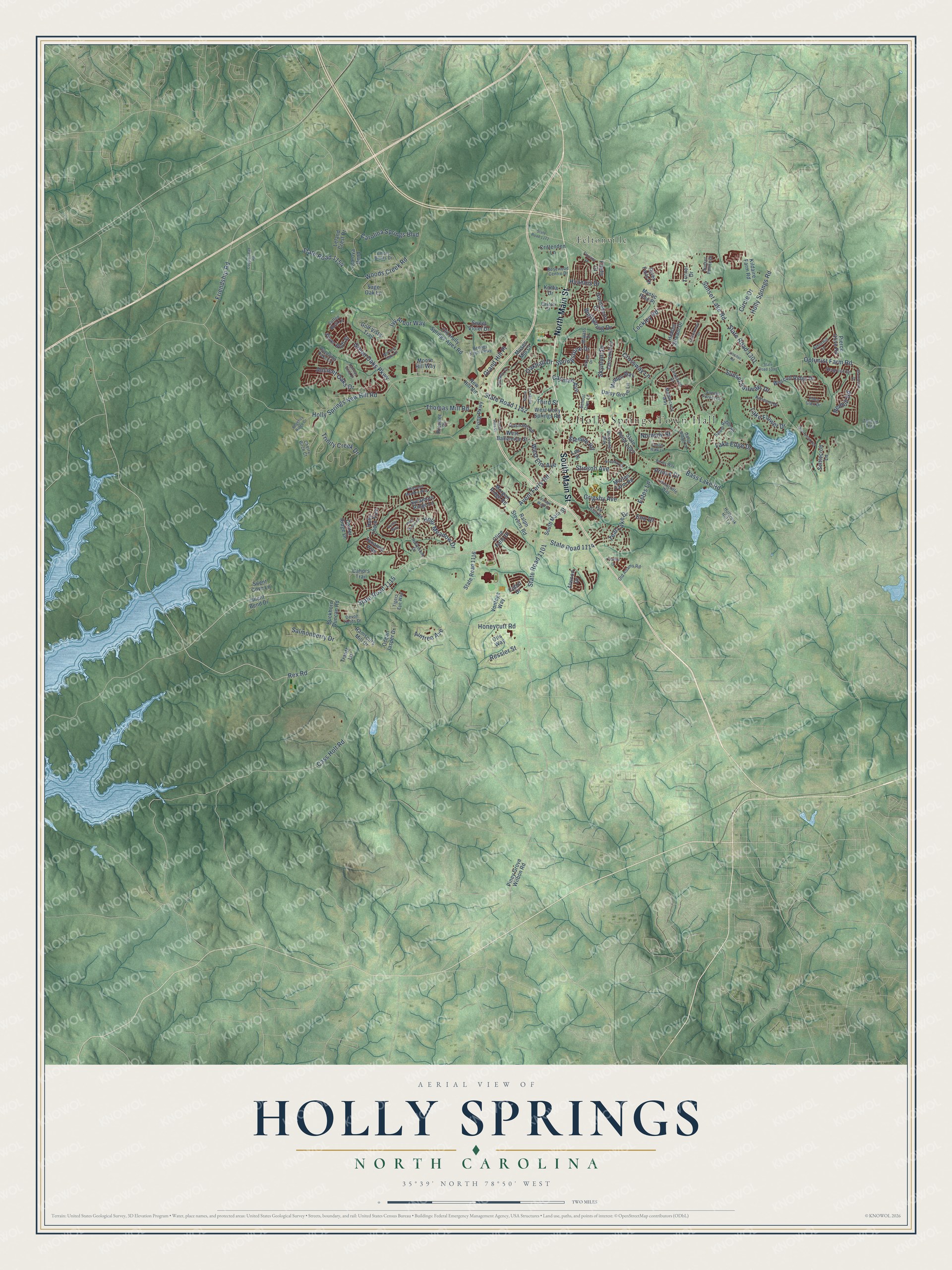
Holly Springs, North Carolina Map Art
Building by building, with labeled streets and shaded relief.
12" x 18" Archival Matte Print
A Map of Home. A Work of Art.
Explore Holly Springs, North Carolina from a whole new perspective. Created using aerial imagery and detailed geographic data, this map captures Holly Springs building by building, with labeled streets, familiar landmarks, and shaded topographical relief that highlights the natural contours of the landscape.
Combining modern data with the timeless character of a vintage atlas, this map is just as interesting up close as it is beautiful on the wall. Whether you grew up in Holly Springs, spent memorable years there, or call it home today, this unique map is a great way to celebrate a place that means something to you. Zoom in on the preview to look for your street, and then order a print to put your memories on the wall.
Three ways to hang it

Unframed archival matte, a black wood frame or a white wood frame.
Up close
Geography Worth Displaying
This map was created using accurate cartographic data and authoritative geographic sources, including the U.S. Geological Survey and the Census Bureau. The map brings together terrain, waterways, roads, and building detail. The majority of the streets are labeled, houses are accurately depicted, and the topography is derived from government sources. Combining local data with carefully composed color and shading leads to this beautifully detailed Holly Springs artwork for your wall.
Rather than simply showing street outlines, we’ve included as many of the street names as we could reasonably fit on the map while keeping their names legible. Zoom in on the high resolution preview to see exactly what’s on the map. We truly set out to create a statement piece for anyone who loves Holly Springs. So whether it’s for you, or a gift for someone you love, we hope this map of Holly Springs brings back fond memories.
Read the story behind this map of Holly Springs, North Carolina from 2026.

Find your street
Names on the Holly Springs map
Every name below is printed on this map. Look for your street, your school, the park where you played, or the pond down the road.
Places and landmarks3
- Holly Springs Town Hall
- Ting Park
- Feltonville
Streets and roads157
- North Main Street
- South Main Street
- Avent Ferry Road
- State Road 1115
- State Road 1101
- State Road 1114
- Teal Lake Drive
- Rex Road
- Ressler Street
- State Road 1152
- State Road 1301
- Sunset Lake Road
- Holly Springs Road
- Green Oaks Parkway
- Holly Springs New Hill Road
- State Road 1154
- Woods Creek Road
- Bass Lake Road
- Lockley Road
- Cass Holt Road
- Grigsby Avenue
- Holly Meadow Drive
- Crossway Lane
- Friendship Road
- Sunset Fairways Drive
- Carolina Springs Boulevard
- Optimist Farm Road
- Ancient Oaks Drive
- Ivy Arbor Way
- Trinity Creek Drive
Show all 157 streets
- Grand Hill Place
- Stinson Avenue
- Thomas Mill Road
- Oakhall Drive
- Skymont Drive
- Lake Edge Drive
- Wellspring Drive
- Cayman Avenue
- Springstone Drive
- West Elm Avenue
- Lake Flower Drive
- Salmonberry Drive
- Norwalk Street
- Redhill Road
- Honeycutt Road
- Hyannis Drive
- Prince Drive
- Circle Drive
- Aintree Avenue
- Eno Drive
- Estes Lane
- Third Street
- Steeple Road
- Piney Grove Wilbon Road
- Ralph Stevens Road
- Texanna Way
- State Road 1393
- State Road 1116
- Old Holly Springs Apex Road
- Sage Oak Lane
- West Holly Springs Road
- Buckhorn Duncan Road
- Holly Thorn Trce
- West Ballentine Street
- Cline Falls Drive
- Dexter Ridge Drive
- Ramsours Mill Drive
- Chrismill Lane
- Morgan Ridge Road
- Golf Vista Trail
- Wescott Ridge Drive
- Kildaire Farm Road
- Carova Bend
- Moore Hill Way
- Cahors Trail
- Irving Parkway
- Midden Way
- Gooseberry Drive
- Morton Farm Road
- Hidden Stream Drive
- Vontega Way
- Pierce Olive Road
- Daisy Grove Lane
- Sweet Violet Drive
- River Falls Drive
- Silver Bluff Street
- Silent Bend Drive
- Mystic Pine Place
- Ocean Jasper Drive
- Settlecroft Lane
- Sycamore Ridge Lane
- Leland Crest Drive
- New Hill Road
- Premier Drive
- Crittenden Lane
- Firefly Court
- Silent Cove Lane
- Atwood Drive
- Katha Drive
- Turner Drive
- Muses Mill Court
- Cabot Drive
- Lee Street
- Trautz Lane
- Otis Way
- Linksland Drive
- Hollymont Drive
- Salem Ridge Road
- Gable Ridge Lane
- Bennet Knoll Parkway
- Sunset Forest Circle
- Rambling Oaks Lane
- Kenmont Drive
- Skygrove Drive
- Milpass Drive
- Arborhill Lane
- Horncliffe Way
- Dutch Hill Road
- Old Adams Road
- Devon Fields Drive
- Middlecrest Way
- Emory Bluffs Drive
- Fair Glen Road
- Sunset Pointe Drive
- Sudano Court
- Cherry Birch Court
- Easton Street
- Rosewood Centre Drive
- School Days Lane
- Coffee Bluff Lane
- Holbrook Hill Lane
- Birdsong Way
- Eden Glen Drive
- Tigers Eye Way
- Talicud Trail
- State Road 1390
- Morning Oaks Drive
- Canterwood Drive
- Sunset Walk Lane
- Bikram Drive
- Fairway Vista Drive
- Lassiter Road
- Magnolia Meadow Way
- Quarryrock Road
- Village Walk Drive
- Grantwood Drive
- Regency Ridge Drive
- Copperhead Road
- State Road 1172
- Holly Green Lane
- Birkby Way
- Noonday Drive
- Stone Hedge Court
- Florians Drive
- Tuska Hills Drive
- Roslin Way
- Praline Drive
Names are listed as they appear on the printed map. Zoom into the product photos to find them.
About Holly Springs, North Carolina
Holly Springs is a town of 41,239 people in Wake County. It grew up at a crossroads where one road ran from Raleigh toward the Cape Fear River and Fayetteville and another ran from Hillsborough to Smithfield. Springs ringed by tall holly trees stood nearby and gave the place its name. Richard Jones opened a general store there, and a Baptist church and a Masonic lodge soon followed. Holly Springs Baptist Church, founded in 1822, became the town's first church to last.
The Civil War emptied the village. Captain Oscar R. Rand signed up local men for the 26th Infantry Regiment, and only 81 of its 880 soldiers survived after Gettysburg. With the men gone, both schools closed. In 1871 historian M. N. Amis called Holly Springs "a deserted village." Recovery began in 1875, when George Benton Alford moved his store here from Middle Creek Township. He added a sawmill, a cotton gin and a newspaper, and the town was incorporated in 1877.
“charmed the soldiers so that they didn't burn the house down, but they did get the chickens.”
- A lodge that was a schoolMasonic Lodge #115 formed in 1847, and its building went up around 1852. It is the only antebellum Masonic lodge left in Wake County and the county's oldest standing lodge and school building. Holly Springs Academy opened in 1854 to ready young men for Wake Forest College, and girls later took classes on the lodge's first floor. The lodge joined the National Register in 2010.
- The Leslie-Alford-Mims HouseArchibald Leslie, a Scottish tailor, came here around 1817 and built a 38-room house near the springs. During the Civil War, Union troops camped near town for two weeks and made the house their headquarters. Mrs. Leslie disliked them but stayed coolly polite, and the house survived. Alford bought it a year after he arrived and enlarged it into one of the biggest mansions in the county, with its own ballroom.
- First black woman police chiefDessie Mae Womble led the Holly Springs police, and no black woman had held that job anywhere in North Carolina before her. James Norris served as the town's first black mayor, and Parrish "Ham" Womble sat on the town council for 28 years and was interim mayor for a year.
- From 900 to nearly 25,000The town opened its first sewage plant in 1987, and growth spilling over from Cary and Apex followed. Holly Springs had 900 people in 1992. Six years later an estimate put it at 6,000, and by 2010 the town held nearly 25,000.
Keep exploring North Carolina
Holly Springs is one of 952 North Carolina towns we've mapped. Every dot on the map is a print of its own.
The search covers every state, North Carolina first.
Near Holly Springs
Order 2 or more town maps and save 10%. Shown in the size and finish you picked above, so they hang as a set.
- Fuquay-Varina 12" x 18" / Archival Matte Print $39.99
- Apex 12" x 18" / Archival Matte Print $39.99
- Willow Springs 12" x 18" / Archival Matte Print $39.99


More maps nearby: Cary, Angier, Mount Vernon, Seaforth and Carpenter.
The art of mapping a place
How This Map Was Made
Real places. Remarkable detail. Discover the layers that turn geographic data into a map of home.

The view from above
Aerial imagery reveals the character of the land: woodland, open fields, and the patterns of a place.

The shape of the land
Elevation data brings hills, valleys, and subtle changes in the landscape into view.

The details of home
Roads, waterways, and building footprints come together to make the map feel unmistakably local.

Geography becomes art
Considered color, shading, and typography bring the layers together in a map made for your wall.


Process illustrated with Mendon, Massachusetts. Aerial imagery: USDA NAIP. Terrain: USGS 3D Elevation Program. Map details and finished artwork: KNOWOL.
The Details
About This Print
Choose an archival matte print, or a black or white Ayous wood frame. The archival matte print is unframed.
Select your size and finish above to see the matching product image and price.
Materials & Craftsmanship
A contemporary map with the character of a classic atlas, printed on archival matte paper. Optional frames are made from Ayous wood.
Your printed map does not include the watermark shown in the full-map preview.
Shipping & Delivery
Free shipping within the United States. Every print is made to order in the USA.
Buying a gift? Add a note in your cart and we'll include it. We never put prices in the package.
Prints ship within 2 to 3 business days. Allow 7 to 10 days total from ordering for delivery. Timing may vary during holidays or periods of high order volume.
Read our shipping policy.
Returns and damaged prints
Each print is made to order. Change-of-mind refunds are not available after production.
If your print arrives damaged, misprinted or incorrect, contact support@knowol.com within 30 days of receiving it. Include your order number, photos and a description of the issue.
Read our full refund and replacement policy. For questions about your order, email support@knowol.com.