
Search for another town


Free U.S. delivery 7 to 10 days after you order
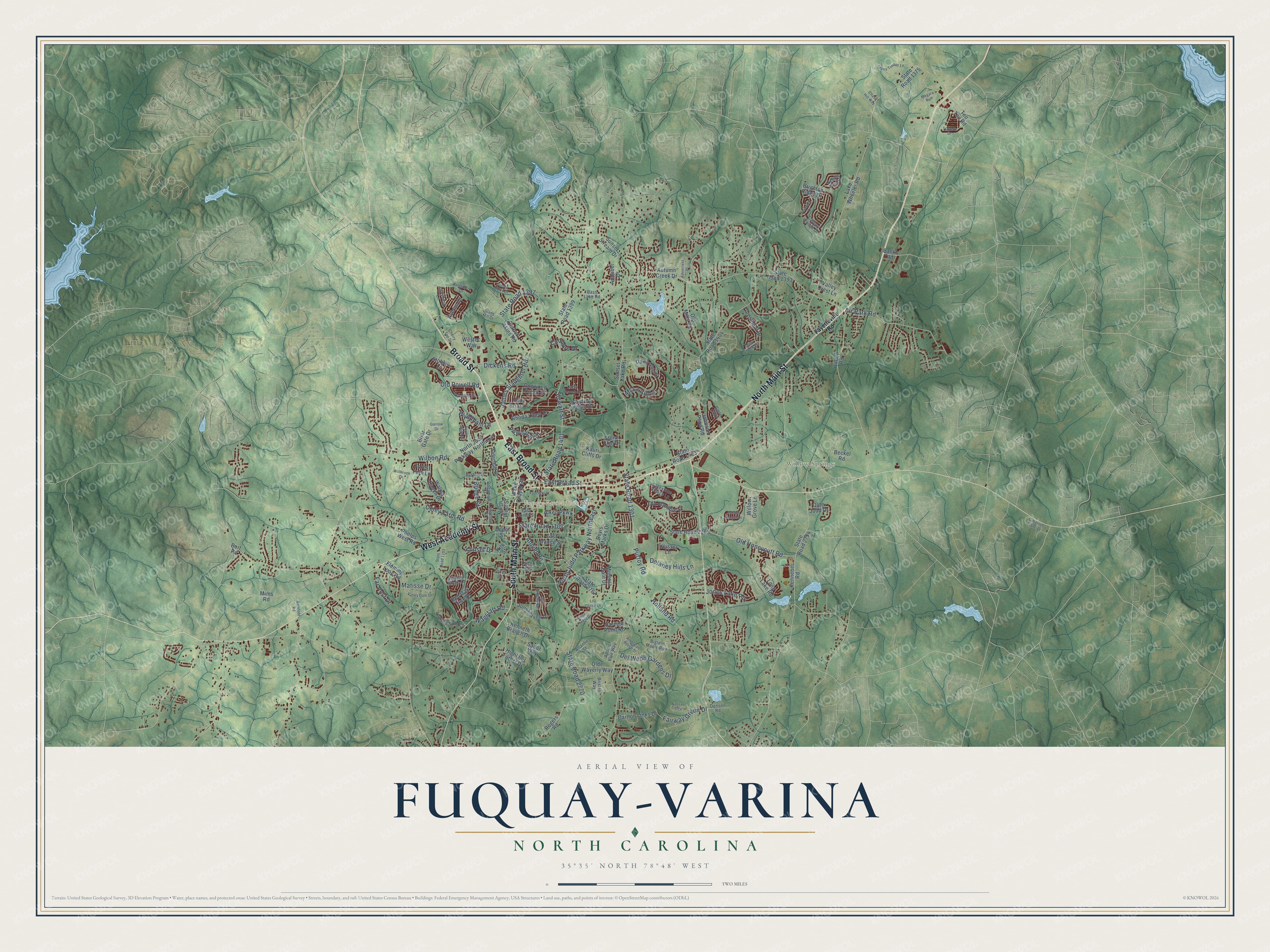
Fuquay-Varina, North Carolina Map Art
Building by building, with labeled streets and shaded relief.
12" x 18" Archival Matte Print
A Map of Home. A Work of Art.
Explore Fuquay-Varina, North Carolina from a whole new perspective. Created using aerial imagery and detailed geographic data, this map captures Fuquay-Varina building by building, with labeled streets, familiar landmarks, and shaded topographical relief that highlights the natural contours of the landscape.
Combining modern data with the timeless character of a vintage atlas, this map is just as interesting up close as it is beautiful on the wall. Whether you grew up in Fuquay-Varina, spent memorable years there, or call it home today, this unique map is a great way to celebrate a place that means something to you. Zoom in on the preview to look for your street, and then order a print to put your memories on the wall.
Three ways to hang it

Unframed archival matte, a black wood frame or a white wood frame.
Up close
Geography Worth Displaying
This map was created using accurate cartographic data and authoritative geographic sources, including the U.S. Geological Survey and the Census Bureau. The map brings together terrain, waterways, roads, and building detail. The majority of the streets are labeled, houses are accurately depicted, and the topography is derived from government sources. Combining local data with carefully composed color and shading leads to this beautifully detailed Fuquay-Varina artwork for your wall.
Rather than simply showing street outlines, we’ve included as many of the street names as we could reasonably fit on the map while keeping their names legible. Zoom in on the high resolution preview to see exactly what’s on the map. We truly set out to create a statement piece for anyone who loves Fuquay-Varina. So whether it’s for you, or a gift for someone you love, we hope this map of Fuquay-Varina brings back fond memories.
Read the story behind this map of Fuquay-Varina, North Carolina from 2026.

Find your street
Names on the Fuquay-Varina map
Every name below is printed on this map. Look for your street, your school, the park where you played, or the pond down the road.
Places and landmarks2
- Fuquay-Varina Town Hall
- Willow Springs
Streets and roads147
- North Main Street
- Broad Street
- South Main Street
- West Academy Street
- East Broad Street
- State Road 1301
- North Judd Parkway Northeast
- Purfoy Road
- Old Honeycutt Road
- Angier Road
- State Road 2770
- Holland Road
- Jones Lake Road
- Stewart Street
- James Slaughter Road
- State Road 1107
- State Road 1401
- Old Powell Road
- McLaurin Lane
- Bridge Street
- Coley Farm Road
- State Road 1397
- Del Webb Gardens Drive
- Sunset Drive
- Dickens Road
- Wilbon Road
- Fairway Green Drive
- Delaney Hills Lane
- Powhatan Drive
- Wagstaff Road
Show all 147 streets
- Air Park Road
- Wyndham Drive
- Culmore Drive
- Far Post Drive
- Matisse Drive
- Johnson Pond Road
- State Road 2765
- State Road 1404
- State Road 1393
- State Road 2767
- North Judd Parkway Northwest
- Sunset Lake Road
- Kennebec Road
- State Road 2754
- Lake Wheeler Road
- State Road 1375
- State Road 1399
- Herbert Akins Road
- Ten Ten Road
- Old Bramble Lane
- Brighton Ridge Drive
- Fleming Loop Road
- Hilltop Road
- Stobhill Lane
- Wake Chapel Road
- Long Lake Road
- Forestbluff Drive
- Kenneth Branch Drive
- East Vance Street
- Alderleaf Drive
- Phelps West Road
- Heisser Lane
- Harvest Point Road
- Minerva Dale Drive
- Carlton Links Drive
- Olde Waverly Way
- Forest Fern Lane
- Sunset Stream Drive
- Rhoda Lilley Drive
- East Ivy Valley Drive
- Averon Drive
- Dairy Glen Drive
- Joneshaven Drive
- Red Oak Tree Drive
- Kauri Cliffs Drive
- Mims Road
- Olde Judd Drive
- Dogwood Creek Place
- Beckel Road
- Briar Gate Drive
- Walker Ranch Drive
- State Road 1403
- North West Street
- Willow Grove Lane
- Westec Way
- Autumn Creek Drive
- Aiken Parkway
- Annabel Drive
- Rogers Road
- Bevis Marks Drive
- Depot Street
- Highland Forest Drive
- Stone Lion Drive
- Holly Briar Drive
- Sailor Way
- Pine Street
- Old Mills Road
- Valley Crest Lane
- Banks Road
- Burt Road
- Kite Street
- Fayetteville Road
- Sequoia Ridge Drive
- Leatherstone Lane
- Bass Lake Road
- Philwood Court
- Atlantis Street
- Ashdale Drive
- Terri Creek Drive
- Cairo Way
- Bristen Way
- Adonis Blue Way
- Ladybank Lane
- Lawrence Street
- Bigleaf Maple Run
- Canopy Woods Drive
- Needle Pine Drive
- East Jones Street
- Lakestone Village Lane
- Burton Street
- Dogwood Street
- Kilmartin Drive
- Denson Road
- Jones Lane
- State Road 1103
- Cross Timber Lane
- Valley Dale Drive
- Glade Mill Court
- Nassau Trce
- Chase Hill Way
- Poplar Ridge Road
- Thurrock Drive
- Willow Ranch Drive
- Sunset Bluffs Drive
- Cabernet Franc Drive
- American Beech Street
- Faucette Street
- Travern Drive
- Adencrest Place
- Megara Run
- Cabin Branch Drive
- Willbrook Drive
- Garrow Drive
- Lily Claire Lane
- Amber Forest Drive
- Cherry Top Drive
- Barefoot Road
Names are listed as they appear on the printed map. Zoom into the product photos to find them.
About Fuquay-Varina, North Carolina
Fuquay-Varina is a town of 34,152 people in southern Wake County. William Fuquay, a Frenchman, was the first to settle at the farming place called Sippihaw. Around 1858 his son Stephen struck a spring while plowing the family's tobacco fields. He came to believe its mineral water could heal, and people came from nearby counties to drink it. In 1860 he sold the spring to a group of men from the area, and they started the Chalybeate Springs Company to market the water and draw visitors.
J. D. "Squire" Ballentine, the local schoolmaster, got letters during his Confederate service from Virginia Avery, who signed them "Varina." He later met her and called her Varina all their life together. In 1880 he became the first postmaster and named the post office Varina for her, and the community south of the spring took that name too. Sippihaw became Fuquay Springs in 1902 and was incorporated in 1909, and the two towns merged as Fuquay-Varina in 1963.
- Moonlight ExcursionsAround the start of the 20th century, John Mills fitted flat rail cars with seats and ran night trains from Raleigh to the spring. Small hotels, restaurants and barbecue stands opened, and dancers met at a pavilion with a player piano. The Fourth of July and Easter Monday brought baseball games and dances. Later, cars and better roads sent travelers to the coast. The spring sits in a park built in 1945 and given to the town in 1998.
- The Ben-Wiley, 1926 to 1947Dr. Wiley S. Cozart owned and ran the Ben-Wiley at 331 South Main Street, and he built his own house across the street from the spring. It served guests as a hotel and restaurant from 1926 until December 17, 1947, and became as central to town life as the spring itself. Today it is the Fuquay Mineral Spring Inn & Garden.
- Varina's tobacco warehousesWhen Fuquay Springs was incorporated in 1909, its limits swallowed Varina's business district and its rail junction. Ballentine lobbied, and the next year Varina got its own Union Station and a new post office. The Bank of Varina opened four years later as a rival to the Bank of Fuquay. Tobacco warehouses rose along the railroad, and by the end of the 1920s there were five of them, a cotton buyer and fifteen stores.
Keep exploring North Carolina
Fuquay-Varina is one of 952 North Carolina towns we've mapped. Every dot on the map is a print of its own.
The search covers every state, North Carolina first.
Near Fuquay-Varina
Order 2 or more town maps and save 10%. Shown in the size and finish you picked above, so they hang as a set.
- Willow Springs 12" x 18" / Archival Matte Print $39.99
- Holly Springs 12" x 18" / Archival Matte Print $39.99
- Angier 12" x 18" / Archival Matte Print $39.99


More maps nearby: Apex, Garner, Cary, Mount Vernon and Lillington.
The art of mapping a place
How This Map Was Made
Real places. Remarkable detail. Discover the layers that turn geographic data into a map of home.

The view from above
Aerial imagery reveals the character of the land: woodland, open fields, and the patterns of a place.

The shape of the land
Elevation data brings hills, valleys, and subtle changes in the landscape into view.

The details of home
Roads, waterways, and building footprints come together to make the map feel unmistakably local.

Geography becomes art
Considered color, shading, and typography bring the layers together in a map made for your wall.


Process illustrated with Mendon, Massachusetts. Aerial imagery: USDA NAIP. Terrain: USGS 3D Elevation Program. Map details and finished artwork: KNOWOL.
The Details
About This Print
Choose an archival matte print, or a black or white Ayous wood frame. The archival matte print is unframed.
Select your size and finish above to see the matching product image and price.
Materials & Craftsmanship
A contemporary map with the character of a classic atlas, printed on archival matte paper. Optional frames are made from Ayous wood.
Your printed map does not include the watermark shown in the full-map preview.
Shipping & Delivery
Free shipping within the United States. Every print is made to order in the USA.
Buying a gift? Add a note in your cart and we'll include it. We never put prices in the package.
Prints ship within 2 to 3 business days. Allow 7 to 10 days total from ordering for delivery. Timing may vary during holidays or periods of high order volume.
Read our shipping policy.
Returns and damaged prints
Each print is made to order. Change-of-mind refunds are not available after production.
If your print arrives damaged, misprinted or incorrect, contact support@knowol.com within 30 days of receiving it. Include your order number, photos and a description of the issue.
Read our full refund and replacement policy. For questions about your order, email support@knowol.com.