
Search for another town


Free U.S. delivery 7 to 10 days after you order
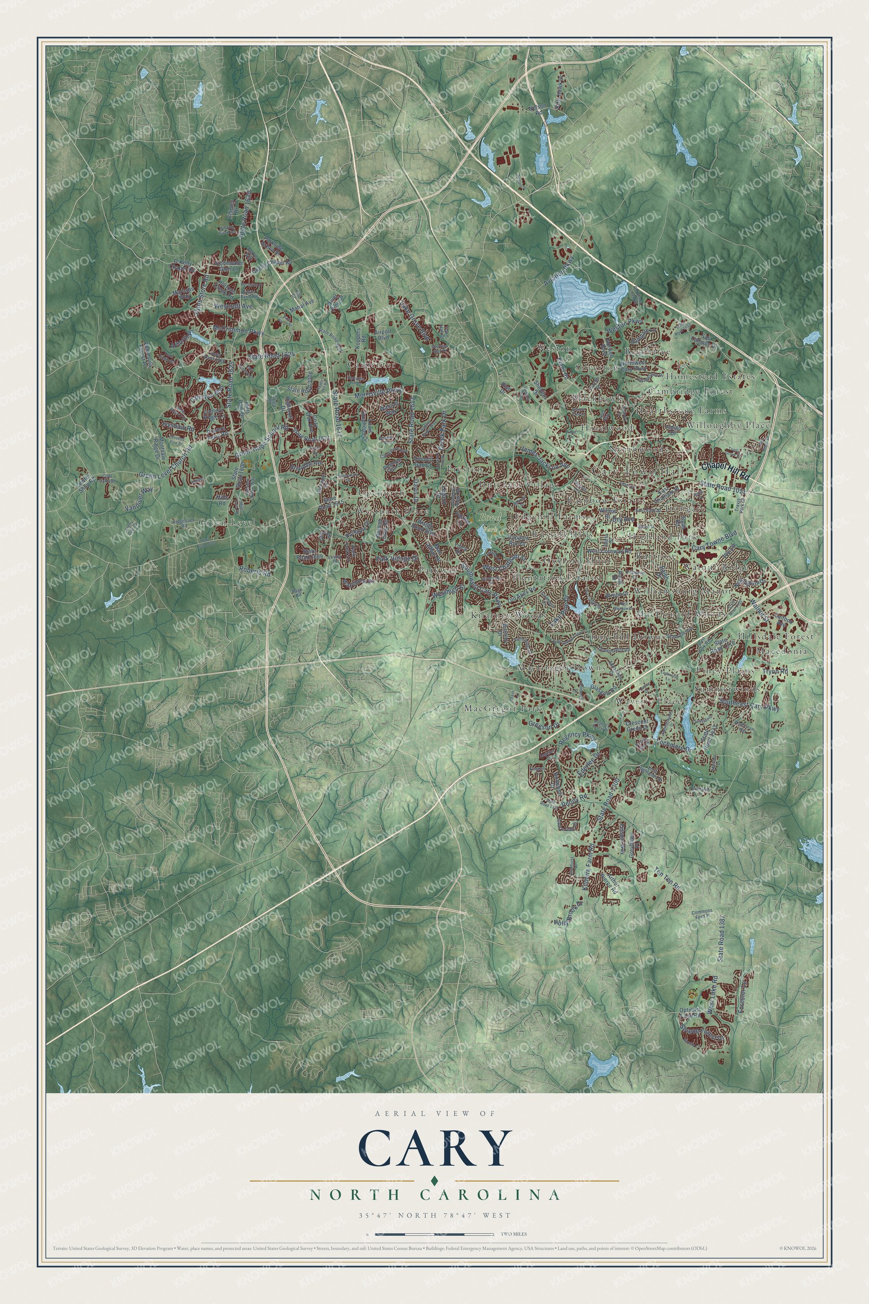
Cary, North Carolina Map Art
Building by building, with labeled streets and shaded relief.
12" x 18" Archival Matte Print
A Map of Home. A Work of Art.
Explore Cary, North Carolina from a whole new perspective. Created using aerial imagery and detailed geographic data, this map captures Cary building by building, with labeled streets, familiar landmarks, and shaded topographical relief that highlights the natural contours of the landscape.
Combining modern data with the timeless character of a vintage atlas, this map is just as interesting up close as it is beautiful on the wall. Whether you grew up in Cary, spent memorable years there, or call it home today, this unique map is a great way to celebrate a place that means something to you. Zoom in on the preview to look for your street, and then order a print to put your memories on the wall.
Three ways to hang it

Unframed archival matte, a black wood frame or a white wood frame.
Up close
Geography Worth Displaying
This map was created using accurate cartographic data and authoritative geographic sources, including the U.S. Geological Survey and the Census Bureau. The map brings together terrain, waterways, roads, and building detail. The majority of the streets are labeled, houses are accurately depicted, and the topography is derived from government sources. Combining local data with carefully composed color and shading leads to this beautifully detailed Cary artwork for your wall.
Rather than simply showing street outlines, we’ve included as many of the street names as we could reasonably fit on the map while keeping their names legible. Zoom in on the high resolution preview to see exactly what’s on the map. We truly set out to create a statement piece for anyone who loves Cary. So whether it’s for you, or a gift for someone you love, we hope this map of Cary brings back fond memories.
Read the story behind this map of Cary, North Carolina from 2026.

Find your street
Names on the Cary map
Every name below is printed on this map. Look for your street, your school, the park where you played, or the pond down the road.
Places and landmarks39
- Cary Town Hall
- Bond Park
- Green Level
- MacGregor Park
- Piney Plains
- Beechtree
- Carpenter
- Westpark Place
- Williamsburg Manor
- Blackhawk
- Waverly Place
- Kilarney Woods
Show all 39 places
- Plantation Estates
- Churchill Downs
- Edgehill Farms
- Hazelwood
- Hearthstone Farms
- Dutchess Village
- Parkway
- Upchurch
- Macedonia
- Preston
- MacGregor Downs
- Weston
- Willoughby Place
- Highland Park
- Russell Hills
- Summerwinds
- Walnut Ridge
- MacDonald Woods
- Oxxford Hunt
- Irongate
- Cambridge Forest
- Silverton
- Homestead Estates
- Northwoods
- Hillsdale Forest
- Burtrose
- Rainbow Estates
Streets and roads205
- Chapel Hill Road
- Southwest Cary Parkway
- Kildaire Farm Road
- State Road 1300
- Morrisville Parkway
- Green Level Church Road
- State Road 1011
- Yates Store Road
- Davis Drive
- State Road 1613
- Tryon Road
- West Chatham Street
- Weston Parkway
- Walnut Street
- Southeast Cary Parkway
- State Road 1625
- Ten Ten Road
- Green Hope School Road
- West Lake Road
- Penny Road
- McCrimmon Parkway
- Lake Pine Drive
- Regency Parkway
- State Road 1630
- Lochmere Drive
- State Road 1387
- State Road 1624
- Lake Grove Boulevard
- Creek Park Drive
- State Road 1617
Show all 205 streets
- Ederlee Drive
- Gregson Drive
- Cary Towne Boulevard
- James Jackson Avenue
- Aviation Parkway
- Serene Forest Drive
- Weycroft Avenue
- Park Village Drive
- Westhigh Street
- Vandiver Way
- Roberts Road
- Ivyshaw Road
- Holly Brook Drive
- Ivy Lane
- Forester Lane
- Allforth Place
- Dry Avenue
- Northwest Cary Parkway
- State Road 1615
- Evans Road
- State Road 1600
- Old Apex Road
- State Road 1423
- Louis Stephens Drive
- Highcroft Drive
- Cary Glen Boulevard
- Okelly Chapel Road
- East Chatham Street
- State Road 1621
- Sas Campus Drive
- Crescent Green Drive
- Ralph Drive
- Glasgow Road
- Walcott Way
- Trappers Run Drive
- O'Kelly Chapel Road
- Hortons Creek Road
- Wakehurst Drive
- Airport Boulevard
- Cozy Oak Avenue
- Optimist Farm Road
- Nelson Road
- Stonewater Glen Lane
- Norwell Boulevard
- Montvale Ridge Drive
- Felspar Way
- Lewter Shop Road
- West Cornwall Road
- Mac Arthur Drive
- Briardale Avenue
- State Road 3006
- Powers Ferry Road
- Nottingham Drive
- Lantern Ridge Lane
- Parkside Green Street
- Arthur Pierce Road
- Kitty Hawk Drive
- Waldo Rood Boulevard
- Parkgate Drive
- State Road 1609
- Caitboo Avenue
- Mills Park Drive
- Legault Drive
- Koppers Road
- Ryan Road
- Pond Street
- State Road 1316
- Marsalis Way
- Greyhawk Place
- Bathgate Lane
- Park York Lane
- Bridewell Court
- Mahal Avenue
- Indigo Drive
- Peninsula Forest Place
- Council Gap Court
- Chipley Drive
- Roland Glen Road
- Wrenn Drive
- Burnley Drive
- River Pine Drive
- Sheldon Drive
- Fairfax Lane
- Mills Road
- Willow Street
- Ymca Drive
- Rise Drive
- Queensferry Road
- Seabrook Avenue
- Loch Highlands Drive
- Annandale Drive
- East Park Street
- State Road 1626
- Livingstone Drive
- State Road 1633
- Griffis Street
- Holsten Bank Way
- Commons Ford Place
- Canon Gate Drive
- Carramore Avenue
- Riggsbee Farm Drive
- Catlin Road
- Kilmayne Drive
- Glenmore Road
- Palace Green
- Twyla Road
- Ridgeback Road
- Evans Farm Road
- Lewey Drive
- Thorpe Drive
- Travis Park Drive
- Arlington Ridge Road
- Cool Oaks Drive
- Praxis Way
- Town Hall Drive
- Page Road
- Kiln Court
- State Road 1652
- State Road 1379
- State Road 1605
- Madison Avenue
- State Road 1716
- Summerwinds Drive
- Lochside Drive
- Hogans Valley Way
- State Road 1432
- High Meadow Drive
- Two Creeks Road
- Angelica Circle
- King George Loop
- Edinburgh Drive
- Trafalgar Lane
- Forest Park Way
- Larkwood Lane
- Sudbury Drive
- Old Reedy Creek Road
- Dominion Hill Drive
- Windstream Way
- Moneta Lane
- Palaver Lane
- Belrose Drive
- Bridle Creek Drive
- Kettlebridge Drive
- Red Grape Drive
- Cary Reserve Drive
- Crooked Pine Drive
- Winding Pine Trail
- Banyon Tree Lane
- Gatehouse Drive
- Lake Drive
- Rosepine Drive
- Allenhurst Place
- Connemara Drive
- Reed Street
- Hayes Hill Place
- Braelands Drive
- Sarabande Drive
- Pine Perch Street
- Regency Forest Drive
- Benwell Court
- Kelekent Lane
- Airgate Drive
- Adams Street
- Toms Creek Road
- Maltland Drive
- Downing Glen Drive
- Mills Farm Road
- Keisler Drive
- Trinity Grove Drive
- Byrum Street
- Wildfell Trail
- Knotty Oaks Drive
- Crash Lane
- Tilth Street
- Anita Way
Names are listed as they appear on the printed map. Zoom into the product photos to find them.
About Cary, North Carolina
Cary is a town of 174,721 people, mostly in western Wake County. In the 1750s John Bradford opened an inn here, and the place was first known as Bradford's Ordinary. The North Carolina Railroad came through in 1854. That same year Allison Francis Page, a Wake County farmer and lumberman, paid $2,000 for 300 acres around the planned junction. He built a home, a sawmill and a general store, and he gave 10 acres for a depot.
Page opened a post office in 1856 and served as its first postmaster. He named the town for Samuel Fenton Cary, who headed the Sons of Temperance across North America and had given a speech in Raleigh two months before. The town became incorporated on April 3, 1871, and Page served as its first mayor. Because he backed temperance, the town's charter banned the sale of whiskey. That ban stayed in force until 1964, long after Page left for Moore County in 1880.
“The sleepy town of Cary...was the ideal place for an emerging class of scientific and technical workers”
- The state's first public high schoolPage and two partners built Cary Academy in 1870 as a private boarding school. Sixteen residents bought it in 1896 and made it Cary High School, and by 1900 its 248 students came from all over the state. When the legislature set up public high schools in 1907, the town sold the school to the State for $2,750. Its 1913 brick building, enlarged in 1939 with WPA help, is now the Cary Arts Center.
- Two armies in April 1865On April 16, 1865, Confederate General Wade Hampton III brought 5,000 soldiers into camp at Cary. A day later Raleigh surrendered, and Union General Francis Preston Blair Jr. made the Nancy Jones House his headquarters. His arrival freed the town's enslaved people, and some of them went on to join the 135th U.S. Colored Troops. Blair stayed until General Joseph E. Johnston surrendered on April 27, 1865.
- Gourd Capital of the WorldA Cary garden club began growing gourds and showing them at the State Fair. After its first Gourd Festival in 1944, the club sent entries to a gourd festival in Pasadena, California, and won many prizes. Cary took the nickname, and gourds ringed the first town seal. The event, now the North Carolina Gourd Festival, moved to the State Fairgrounds in 2000.
- Growth after 1959Research Triangle Park opened nearby in 1959, and Cary grew from 3,356 people in 1960 to 7,686 in 1970. In 1971 the town created zoning that let builders plan a whole community at once. The first in North Carolina was Kildaire Farms, 967 acres on an old dairy farm. By 2000 Cary had 94,536 people.
Keep exploring North Carolina
Cary is one of 952 North Carolina towns we've mapped. Every dot on the map is a print of its own.
The search covers every state, North Carolina first.
Near Cary
Order 2 or more town maps and save 10%. Shown in the size and finish you picked above, so they hang as a set.
- Carpenter 12" x 18" / Archival Matte Print $39.99
- Morrisville 12" x 18" / Archival Matte Print $39.99
- Apex 12" x 18" / Archival Matte Print $39.99


More maps nearby: Mount Vernon, Holly Springs, Raleigh, Seaforth and Carolina Meadows.
The art of mapping a place
How This Map Was Made
Real places. Remarkable detail. Discover the layers that turn geographic data into a map of home.

The view from above
Aerial imagery reveals the character of the land: woodland, open fields, and the patterns of a place.

The shape of the land
Elevation data brings hills, valleys, and subtle changes in the landscape into view.

The details of home
Roads, waterways, and building footprints come together to make the map feel unmistakably local.

Geography becomes art
Considered color, shading, and typography bring the layers together in a map made for your wall.


Process illustrated with Mendon, Massachusetts. Aerial imagery: USDA NAIP. Terrain: USGS 3D Elevation Program. Map details and finished artwork: KNOWOL.
The Details
About This Print
Choose an archival matte print, or a black or white Ayous wood frame. The archival matte print is unframed.
Select your size and finish above to see the matching product image and price.
Materials & Craftsmanship
A contemporary map with the character of a classic atlas, printed on archival matte paper. Optional frames are made from Ayous wood.
Your printed map does not include the watermark shown in the full-map preview.
Shipping & Delivery
Free shipping within the United States. Every print is made to order in the USA.
Buying a gift? Add a note in your cart and we'll include it. We never put prices in the package.
Prints ship within 2 to 3 business days. Allow 7 to 10 days total from ordering for delivery. Timing may vary during holidays or periods of high order volume.
Read our shipping policy.
Returns and damaged prints
Each print is made to order. Change-of-mind refunds are not available after production.
If your print arrives damaged, misprinted or incorrect, contact support@knowol.com within 30 days of receiving it. Include your order number, photos and a description of the issue.
Read our full refund and replacement policy. For questions about your order, email support@knowol.com.