


Search for another town


Free U.S. delivery 7 to 10 days after you order
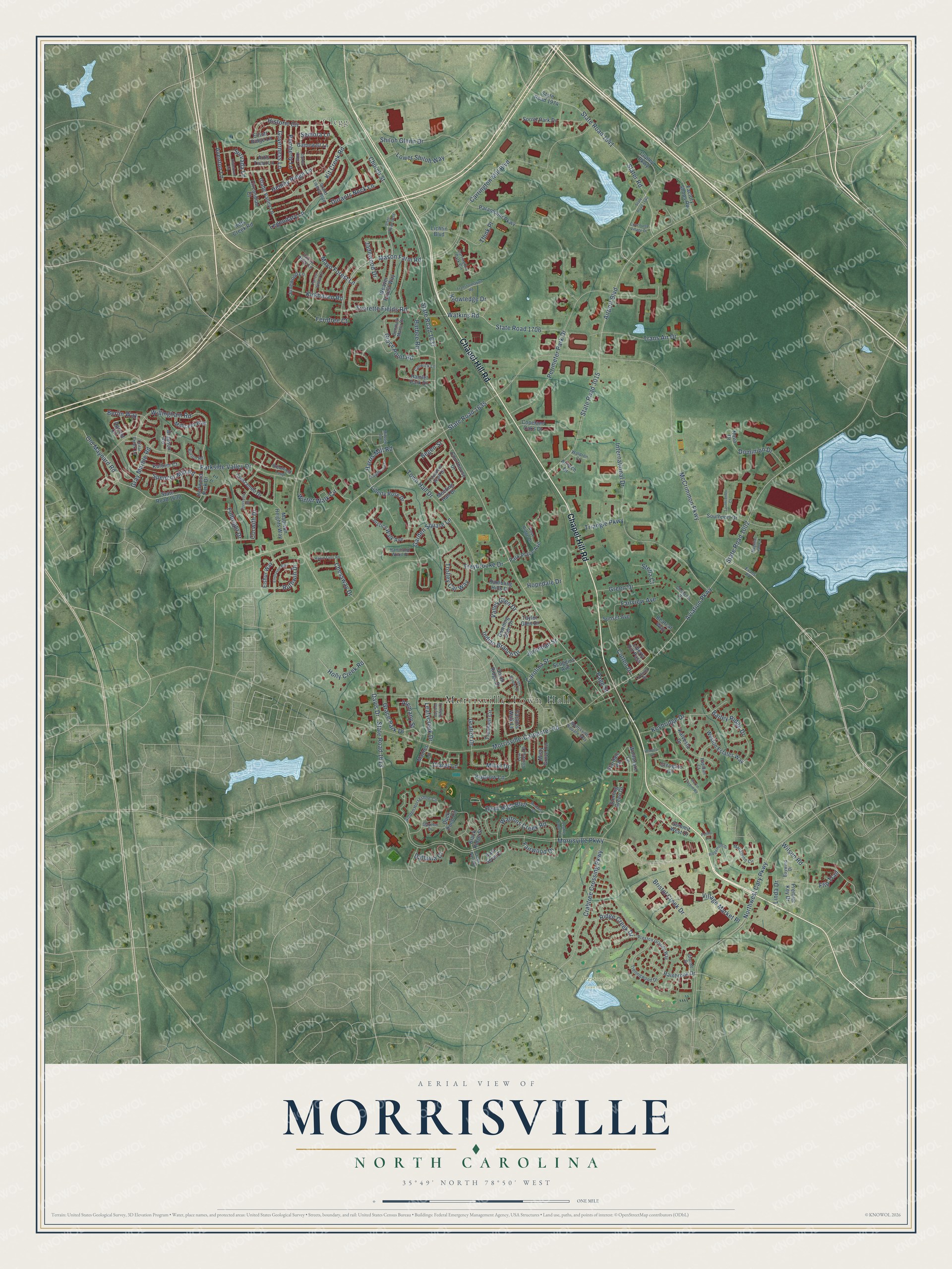
Morrisville, North Carolina Map Art
Building by building, with labeled streets and shaded relief.
12" x 18" Archival Matte Print
A Map of Home. A Work of Art.
Explore Morrisville, North Carolina from a whole new perspective. Created using aerial imagery and detailed geographic data, this map captures Morrisville building by building, with labeled streets, familiar landmarks, and shaded topographical relief that highlights the natural contours of the landscape.
Combining modern data with the timeless character of a vintage atlas, this map is just as interesting up close as it is beautiful on the wall. Whether you grew up in Morrisville, spent memorable years there, or call it home today, this unique map is a great way to celebrate a place that means something to you. Zoom in on the preview to look for your street, and then order a print to put your memories on the wall.
Three ways to hang it

Unframed archival matte, a black wood frame or a white wood frame.
Up close
Geography Worth Displaying
This map was created using accurate cartographic data and authoritative geographic sources, including the U.S. Geological Survey and the Census Bureau. The map brings together terrain, waterways, roads, and building detail. The majority of the streets are labeled, houses are accurately depicted, and the topography is derived from government sources. Combining local data with carefully composed color and shading leads to this beautifully detailed Morrisville artwork for your wall.
Rather than simply showing street outlines, we’ve included as many of the street names as we could reasonably fit on the map while keeping their names legible. Zoom in on the high resolution preview to see exactly what’s on the map. We truly set out to create a statement piece for anyone who loves Morrisville. So whether it’s for you, or a gift for someone you love, we hope this map of Morrisville brings back fond memories.
Read the story behind this map of Morrisville, North Carolina from 2026.

Find your street
Names on the Morrisville map
Every name below is printed on this map. Look for your street, your school, the park where you played, or the pond down the road.
Places and landmarks3
- Morrisville Town Hall
- Clegg
- Prestonwood Country Club
Streets and roads199
- Chapel Hill Road
- Davis Drive
- Harris Mill Road
- Morrisville Parkway
- McCrimmon Parkway
- Church Street
- State Road 1637
- Carrington Mill Boulevard
- Northwest Cary Parkway
- Morrisville-Carpenter Road
- Airport Boulevard
- Town Hall Drive
- Aviation Parkway
- State Road 1002
- State Road 3015
- State Road 1635
- Perimeter Park Drive
- Crabtree Crossing Parkway
- Kit Creek Road
- State Road 1613
- Parkside Valley Drive
- Slater Road
- International Drive
- Old Maynard Road
- State Road 1641
- Grace Point Road
- Historic Circle
- Willingham Road
- Shiloh Glenn Drive
- Winter Walk Circle
Show all 199 streets
- Garden Square Lane
- Mason Farm Road
- State Road 1706
- Watkins Road
- Legendary Lane
- Hemby Ridge Lane
- Bristol Creek Drive
- Carolina Street
- Indian Branch Drive
- Lower Shiloh Way
- Quail High Boulevard
- Waltons Creek Road
- Trolley Car Way
- Everette Fields Road
- Trans Air Drive
- Keybridge Drive
- Alemany Street
- Durants Neck Lane
- Village Market Place
- Valley Glen Drive
- Kudrow Lane
- Bailey Ridge Drive
- Begen Street
- Barbee Road
- Spencor Mill Road
- Green Drive
- Treybrooke Drive
- Corwith Drive
- Cotten Drive
- Jadewood Drive
- Governess Lane
- Mayo Forest Lane
- Flip Trail
- Think Place
- Ridge Creek Drive
- Holly Creek Road
- Dominion Drive
- Wilson Road
- Fairview Avenue
- Kirkhaven Road
- Pemberly Lane
- Page Street
- Millet Drive
- Fairwood Drive
- Claret Lane
- Ferntree Court
- Triangle Parkway
- Grace Park Drive
- Jeremiah Street
- Survada Lane
- Gratiot Drive
- Gray Marble Road
- Chessway Drive
- Leafycreek Drive
- Knowledge Drive
- Aventon Lane
- Hopedale Drive
- Berlin Way
- Fulbright Drive
- Ruthwin Drive
- Dallavia Court
- Stella Court
- Semora Lane
- Linda Drive
- Rainbrook Drive
- Liberty Hill Pass
- State Road 1632
- Paramount Parkway
- Weaver Forest Way
- Sorrel Park Drive
- Duck Pond Circle
- Southport Drive
- Downing Glen Drive
- Liberty Rose Drive
- Madison Heights Way
- Glengate Circle
- Misty Grove Circle
- Justice Walk Avenue
- Sterling Green Drive
- Hamlet Park Drive
- Park Place Avenue
- Glade Valley Lane
- Meeting Hall Drive
- Trumbell Circle
- Crescendo Drive
- Weston Estates Way
- Copley Parkway
- Kalvesta Drive
- Courthouse Drive
- Rambling Hills Drive
- Union Ridge Drive
- Millicent Way
- Copeland Oaks Drive
- Gamewell Lane
- Factory Shops Road
- Wolfsnare Lane
- Circandian Court
- Kurtner Court
- Black Ridge Street
- Redwood Park Drive
- Junewood Lane
- Kitts Creek Road
- Summit West Drive
- Elliott Ridge Lane
- Premier Key Drive
- Stardale Road
- Scoggins Avenue
- Sunset Avenue
- Elshur Way
- Factors Walk Lane
- Artis Town Lane
- Lichtin Boulevard
- Bearcat Way
- State Road 1974
- East Seve Court
- Apricot Circle
- Madres Lane
- Taylor Glen Drive
- Bradson Road
- Nova Drive
- Airtech Drive
- Preston Grande Way
- Evans Road
- Carrington Park Circle
- Golden Horseshoe Circle
- Trellingwood Drive
- Denmark Manor Drive
- Rose Ridge Drive
- Brentfield Loop
- Grand Liberty Boulevard
- Founders Walk Drive
- Macalpine Circle
- Colwick Lane
- Clements Drive
- Baywind Drive
- Coral Creek Lane
- Morrisville Square Way
- Hammond Wood Place
- Grande Drive
- Falcon Ridge Lane
- Gazebo Drive
- Low Country Court
- Button Road
- Cotulla Drive
- Rapidan Court
- Waldron Court
- Creek Park Drive
- Ridgemere Drive
- State Road 1638
- Transformation Road
- Oatney Ridge Lane
- Elmhaven Way
- Craigmeade Drive
- Dyersville Drive
- Forrest Willow Lane
- Vista Brooke Drive
- Magellan Lab Court
- Midvale Avenue
- Double Eagle Court
- Martin Tavern Road
- Southcenter Court
- Hildebran Lane
- Rapid Falls Road
- Concourse Village Drive
- Medalist Drive
- State Road 1640
- Bayless Ridge Court
- Henrico Lane
- Paddy Lane
Names are listed as they appear on the printed map. Zoom into the product photos to find them.
About Morrisville, North Carolina
Morrisville is a town of 29,630 people, mostly in Wake County with a small part in Durham County, midway between Raleigh and Durham. When the North Carolina Railroad came through in 1852, Jeremiah Morris gave the company land for a depot, a water tower and other buildings, and the station took his name. Roads to Chapel Hill, Raleigh and Hillsborough crossed here, so a town grew up around the stop.
Morrisville received its town charter in 1875. The town lost its incorporation in 1933, and its charter wasn't restored until 1947. In September 2025 the town broke ground on a planned 25-acre town center that takes in its historic buildings, library and Indian Creek Trailhead, with the first phase scheduled to open in 2027.
“The next night, a courier from the Confederate commander, General Joseph E. Johnston, rode into the Union camp at Morrisville with a truce proposal.”
- The last big cavalry fightIn April 1865, after taking Raleigh, Union cavalry chased the retreating Confederates west along the railroad, skirmishing on the Hillsborough Road all the way to Morrisville. There they struck a Confederate train carrying wounded soldiers and a load of supplies. The Confederates held them off long enough for the cars carrying the wounded to escape, but they had to leave the supplies behind. It was the final major cavalry fight of Sherman's campaign.
- Toward the war's endJohnston's truce offer, carried into the Union camp at Morrisville, led to talks between him and Sherman. Those talks ended on April 26 with the Civil War's largest Confederate surrender, signed at the Bennett Farm in Durham.
Keep exploring North Carolina
Morrisville is one of 952 North Carolina towns we've mapped. Every dot on the map is a print of its own.
The search covers every state, North Carolina first.
Near Morrisville
Order 2 or more town maps and save 10%. Shown in the size and finish you picked above, so they hang as a set.
- Carpenter 12" x 18" / Archival Matte Print $39.99
- Cary 12" x 18" / Archival Matte Print $39.99
- Mount Vernon 12" x 18" / Archival Matte Print $39.99


More maps nearby: Apex, Carolina Meadows, Durham, Governors Village and Raleigh.
The art of mapping a place
How This Map Was Made
Real places. Remarkable detail. Discover the layers that turn geographic data into a map of home.

The view from above
Aerial imagery reveals the character of the land: woodland, open fields, and the patterns of a place.

The shape of the land
Elevation data brings hills, valleys, and subtle changes in the landscape into view.

The details of home
Roads, waterways, and building footprints come together to make the map feel unmistakably local.

Geography becomes art
Considered color, shading, and typography bring the layers together in a map made for your wall.


Process illustrated with Mendon, Massachusetts. Aerial imagery: USDA NAIP. Terrain: USGS 3D Elevation Program. Map details and finished artwork: KNOWOL.
The Details
About This Print
Choose an archival matte print, or a black or white Ayous wood frame. The archival matte print is unframed.
Select your size and finish above to see the matching product image and price.
Materials & Craftsmanship
A contemporary map with the character of a classic atlas, printed on archival matte paper. Optional frames are made from Ayous wood.
Your printed map does not include the watermark shown in the full-map preview.
Shipping & Delivery
Free shipping within the United States. Every print is made to order in the USA.
Buying a gift? Add a note in your cart and we'll include it. We never put prices in the package.
Prints ship within 2 to 3 business days. Allow 7 to 10 days total from ordering for delivery. Timing may vary during holidays or periods of high order volume.
Read our shipping policy.
Returns and damaged prints
Each print is made to order. Change-of-mind refunds are not available after production.
If your print arrives damaged, misprinted or incorrect, contact support@knowol.com within 30 days of receiving it. Include your order number, photos and a description of the issue.
Read our full refund and replacement policy. For questions about your order, email support@knowol.com.