
Search for another town


Free U.S. delivery 7 to 10 days after you order
Huntersville, North Carolina Map Art
Building by building, with labeled streets and shaded relief.
12" x 18" Archival Matte Print
A Map of Home. A Work of Art.
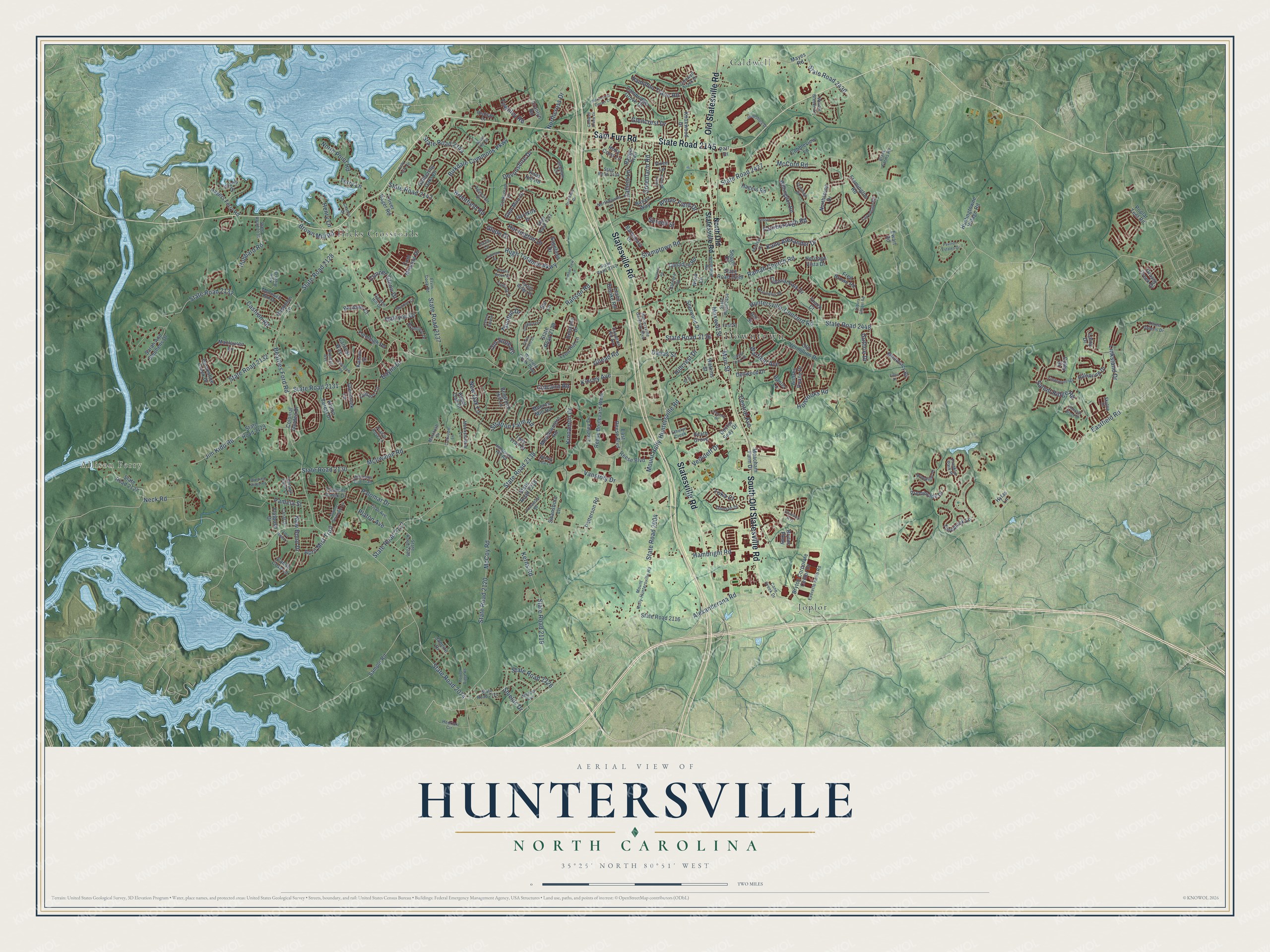
Explore Huntersville, North Carolina from a whole new perspective. Created using aerial imagery and detailed geographic data, this map captures Huntersville building by building, with labeled streets, familiar landmarks, and shaded topographical relief that highlights the natural contours of the landscape.
Combining modern data with the timeless character of a vintage atlas, this map is just as interesting up close as it is beautiful on the wall. Whether you grew up in Huntersville, spent memorable years there, or call it home today, this unique map is a great way to celebrate a place that means something to you. Zoom in on the preview to look for your street, and then order a print to put your memories on the wall.
Three ways to hang it

Unframed archival matte, a black wood frame or a white wood frame.
Up close
Geography Worth Displaying
This map was created using accurate cartographic data and authoritative geographic sources, including the U.S. Geological Survey and the Census Bureau. The map brings together terrain, waterways, roads, and building detail. The majority of the streets are labeled, houses are accurately depicted, and the topography is derived from government sources. Combining local data with carefully composed color and shading leads to this beautifully detailed Huntersville artwork for your wall.
Rather than simply showing street outlines, we’ve included as many of the street names as we could reasonably fit on the map while keeping their names legible. Zoom in on the high resolution preview to see exactly what’s on the map. We truly set out to create a statement piece for anyone who loves Huntersville. So whether it’s for you, or a gift for someone you love, we hope this map of Huntersville brings back fond memories.
Read the story behind this map of Huntersville, North Carolina from 2026.

Find your street
Names on the Huntersville map
Every name below is printed on this map. Look for your street, your school, the park where you played, or the pond down the road.
Places and landmarks5
- Downtown
- Allison Ferry
- Caldwell
- Hicks Crossroads
- Joplor
Streets and roads270
- Statesville Road
- Sam Furr Road
- State Road 2145
- South Old Statesville Road
- Old Statesville Road
- State Road 2226
- Beatties Ford Road
- Gilead Road
- Hambright Road
- State Road 2074
- State Road 2136
- State Road 2117
- State Road 2128
- McCoy Road
- Mount Holly-Huntersville Road
- State Road 2004
- McIlwaine Road
- McCord Road
- Stumptown Road
- Neck Road
- Huntersville-Concord Road
- State Road 2130
- State Road 2120
- Kerns Road
- State Road 2119
- State Road 2448
- Devonshire Drive
- State Road 2427
- Alexanderana Road
- State Road 2138
Show all 270 streets
- Cashion Road
- Northcross Drive
- Ramah Church Road
- State Road 2133
- State Road 2131
- State Road 2137
- Birkdale Commons Parkway
- Ranson Road
- Jim Kidd Road
- Vanstory Drive
- Holbrooks Road
- Stratton Farm Road
- Verhoeff Drive
- Salem Ridge Road
- April Mist Trail
- Main Street
- Hugh Torance Parkway
- Brentfield Road
- Spruell Street
- Warfield Avenue
- Kincey Avenue
- Palomar Drive
- Hillcrest Drive
- Eastfield Road
- Hubbard Road
- State Road 2132
- Linksland Drive
- Dallas Street
- Harvington Drive
- State Road 2144
- Hampton Trace Road
- Kane Alexander Drive
- New Oak Lane
- State Road 2430
- Greenfarm Road
- Central Avenue
- Pamela Street
- State Road 2143
- Townley Road
- North Point Road
- Old Store Road
- Brown Mill Road
- New Bond Drive
- Conner Glenn Drive
- Halcyon Drive
- Farnborough Road
- Terry Lane
- Platon Avenue
- Amber Field Drive
- Henry Lane
- Culcairn Road
- Toka Court
- Glencrest Drive
- Kinnamon Drive
- Glade Court
- Guthrie Drive
- Baylis Drive
- Taunton Drive
- Maxwell Street
- Tallent Lane
- Shields Drive
- North Old Statesville Road
- Reese Boulevard West
- East Reese Boulevard
- Heath Grove
- State Road 2116
- Colonial Garden Drive
- State Road 2439
- Old Vermillion Drive
- State Road 2139
- State Road 2129
- Reese Boulevard
- Mayes Road
- Willingdon Road
- Monocacy Bv
- Baytown Court
- Colonial Park Drive
- Northstone Drive
- Twin Trail Drive
- Cambridge Grove Drive
- Glen Miro Drive
- Sherwood Drive
- Angel Oak Drive
- State Road 2127
- Tosomock Lane
- Lyon Hill Lane
- Tanners Creek Drive
- Grassy Creek Drive
- Rhiannon Lane
- Vixen Lane
- Bradford Hill Lane
- Knoxwood Drive
- Bryton Corporate Center Drive
- Andres Duany Drive
- Cantrell Way
- Foreleigh Road
- Hagers Road
- Bryton Parkway
- Dellwood Drive
- Promenade Drive
- Oliver Hager Road
- Hillspring Drive
- Barnsbury Drive
- Alston Forest Drive
- Sarah Ann Stephens Drive
- Hagers Ferry Road
- Cobbleview Lane
- Garnkirk Drive
- Meadowmere Road
- Coley Drive
- Ranger Trail
- Huntingtowne Village Road
- Canadice Road
- Meacham Farm Drive
- Fred Brown Road
- Patterson Road
- Canoe Cove Lane
- Flatbush Drive
- Heritage Vista Drive
- Delstone Drive
- Leisure Lane
- State Road 2218
- Poplar Tent Road
- Gathering Oaks Drive
- Glencreek Lane
- Moores Mill Road
- Fremington Road
- Swansboro Lane
- Bayart Way
- Cool Meadow Drive
- Sample Road
- Doctor Seay Drive
- Horseshoe Creek Drive
- Leslie Brooke Road
- Maclauren Lane
- Lafoy Drive
- Knox Hill Road
- Island Drive
- Sagefield Drive
- Lindley Drive
- Seagle Drive
- Watkins Street
- Holly Crest Lane
- Janeiro Drive
- Cranlyn Road
- Thach Court
- Banter Lane
- Hylas Lane
- Kalson Street
- Nitsa Lane
- Ewart Road
- Parr Drive
- Hill Street
- Bur Lane
- State Road 2121
- Wynfield Creek Parkway
- State Road 2140
- State Road 2454
- Ervin Cook Road
- Southland Road
- State Road 2134
- McDowell Run Drive
- State Road 2434
- Caldwell Track Drive
- Willow Breeze Lane
- Henderson Hill Road
- Grenfell Avenue
- Everette Keith Road
- Garden Hill Drive
- Journeys End Trail
- Bramfield Drive
- Titan Avenue
- Damson Drive
- Northdowns Lane
- Franklin Park Place
- State Road 2141
- State Road 2238
- Agincourt Drive
- New River Drive
- Brookline Place
- Myston Lane
- Cockerham Lane
- Windy Lea Lane
- Huntersville Gateway Boulevard
- Three Greens Drive
- Grafham Circle
- Black Farms Road
- Mercia Avenue
- Lavenham Road
- Vantage Point Lane
- McIntosh Drive
- Moonshadow Lane
- Canal Drive
- Glenora Drive
- Redcliff Drive
- Rosedale Hill Avenue
- Prairie Rose Lane
- Skytop Drive
- Cane Creek Drive
- Tartan Ridge Drive
- Ethelyn Creek
- Hedrick Circle
- Cramur Drive
- First Street
- Lizzie Lane
- Hunters Road
- Asbury Chapel Road
- Northcross Center Court
- Pavilion Estates Drive
- Kelly Park Circle
- Summer Serenade Drive
- Saint Barts Lane
- Aberfeld Road
- Stonegreen Lane
- Gibson Park Drive
- Bravington Road
- Timberview Lane
- Alba Rose Lane
- Timbergreen Drive
- Cranleigh Drive
- Ulsten Lane
- Cheverly Drive
- Howell Ridge Road
- Jamesburg Drive
- Brookway Drive
- Winding Ridge Road
- Beech Hill Drive
- Oxford Hollow
- Taybrook Drive
- Crabapple Lane
- Emerald Wood Drive
- Caledenia Drive
- Comanche Road
- Caldwell Creek Drive
- Oakham Street
- Fiore Place
- Chantrey Way
- South Brent Drive
- Breton Brook Street
- Lee Drive
Names are listed as they appear on the printed map. Zoom into the product photos to find them.
About Huntersville, North Carolina
Huntersville is a town of 61,376 people in northern Mecklenburg County, 14 miles north of Charlotte. Its first name was Craighead. It was later renamed to honor Robert Boston Hunter, a cotton farmer who owned land here, and it was incorporated as a town in 1873.
Two man-made lakes on the Catawba River frame the town. Duke Power built Lake Norman, along the northwestern border, to serve its nuclear plant. Mountain Island Lake lies on the southwest side and supplies Charlotte with its water.
- General Davidson's last battleGeneral Davidson died fighting at Cowan's Ford, close to where Huntersville stands today. Founders of a new school later chose his name for it. In an August announcement, they said it would be called Davidson College in his memory.
- Home of Joe Gibbs RacingThe NASCAR team Joe Gibbs Racing is based in Huntersville. Its drivers Bobby Labonte, Tony Stewart and Kyle Busch have brought it five Cup Series championships, and the team has won more than 190 Cup races.
Keep exploring North Carolina
Huntersville is one of 952 North Carolina towns we've mapped. Every dot on the map is a print of its own.
The search covers every state, North Carolina first.
Near Huntersville
Order 2 or more town maps and save 10%. Shown in the size and finish you picked above, so they hang as a set.
- Cornelius 12" x 18" / Archival Matte Print $39.99
- Davidson 12" x 18" / Archival Matte Print $39.99
- Lowesville 12" x 18" / Archival Matte Print $39.99


More maps nearby: Westport, Mountain Island, Mount Holly, Lake Norman of Iredell and Biddleville.
The art of mapping a place
How This Map Was Made
Real places. Remarkable detail. Discover the layers that turn geographic data into a map of home.

The view from above
Aerial imagery reveals the character of the land: woodland, open fields, and the patterns of a place.

The shape of the land
Elevation data brings hills, valleys, and subtle changes in the landscape into view.

The details of home
Roads, waterways, and building footprints come together to make the map feel unmistakably local.

Geography becomes art
Considered color, shading, and typography bring the layers together in a map made for your wall.


Process illustrated with Mendon, Massachusetts. Aerial imagery: USDA NAIP. Terrain: USGS 3D Elevation Program. Map details and finished artwork: KNOWOL.
The Details
About This Print
Choose an archival matte print, or a black or white Ayous wood frame. The archival matte print is unframed.
Select your size and finish above to see the matching product image and price.
Materials & Craftsmanship
A contemporary map with the character of a classic atlas, printed on archival matte paper. Optional frames are made from Ayous wood.
Your printed map does not include the watermark shown in the full-map preview.
Shipping & Delivery
Free shipping within the United States. Every print is made to order in the USA.
Buying a gift? Add a note in your cart and we'll include it. We never put prices in the package.
Prints ship within 2 to 3 business days. Allow 7 to 10 days total from ordering for delivery. Timing may vary during holidays or periods of high order volume.
Read our shipping policy.
Returns and damaged prints
Each print is made to order. Change-of-mind refunds are not available after production.
If your print arrives damaged, misprinted or incorrect, contact support@knowol.com within 30 days of receiving it. Include your order number, photos and a description of the issue.
Read our full refund and replacement policy. For questions about your order, email support@knowol.com.