


Search for another town


Free U.S. delivery 7 to 10 days after you order
Johnston, Rhode Island Map Art
Building by building, with labeled streets and shaded relief.
12" x 18" Archival Matte Print
A Map of Home. A Work of Art.
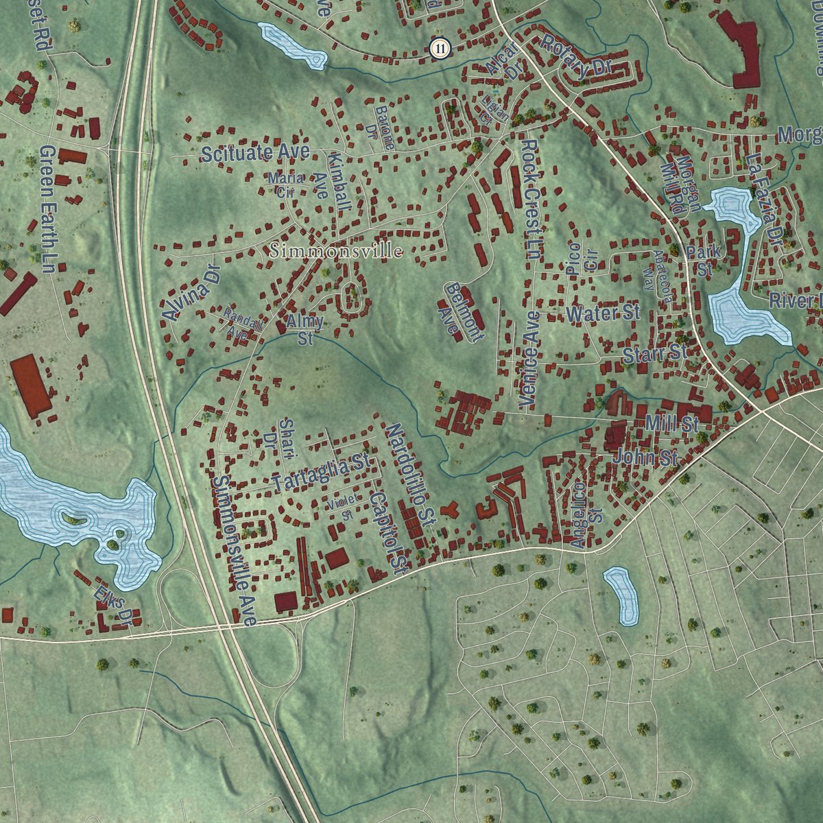
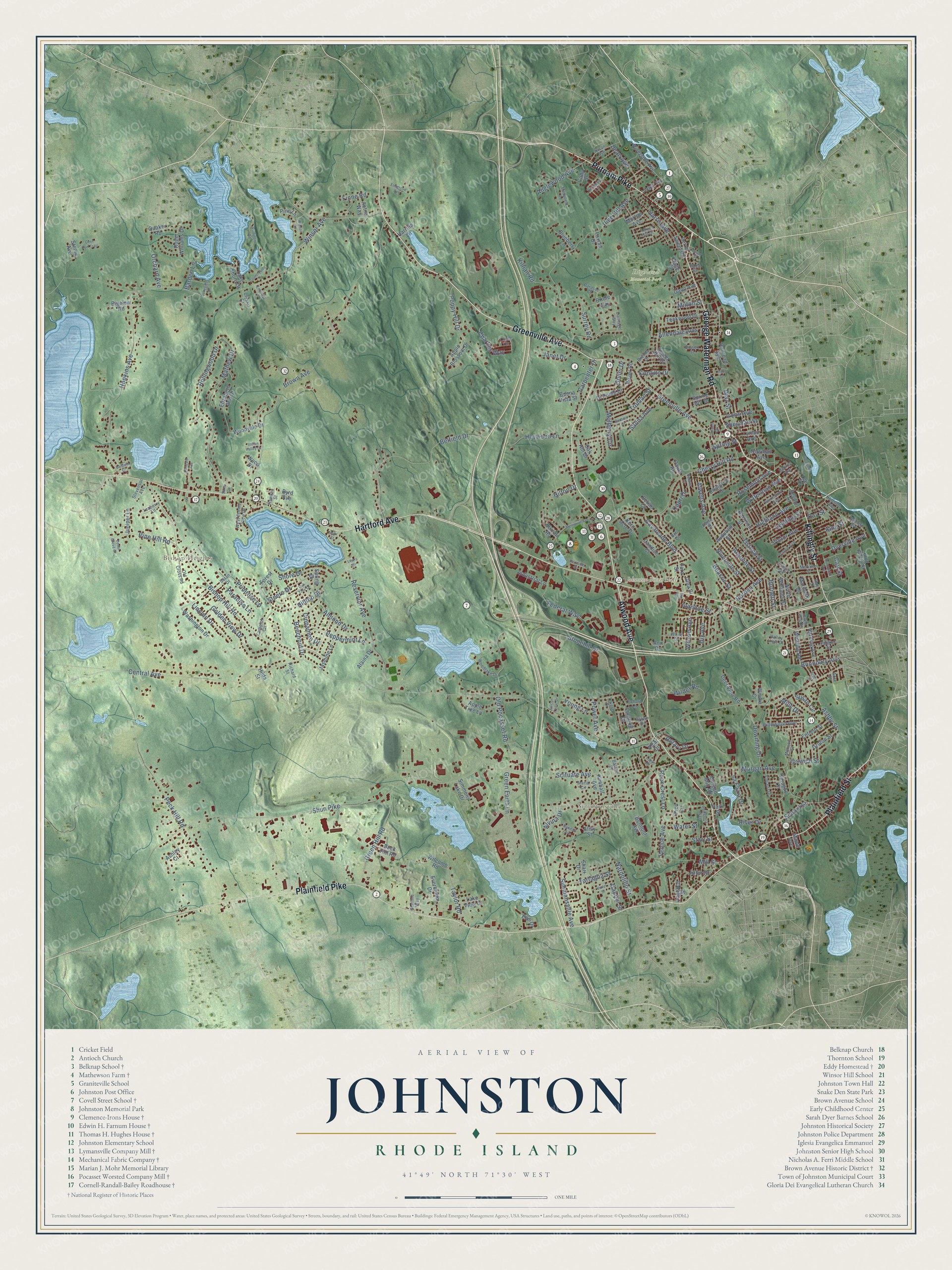
Explore Johnston, Rhode Island from a whole new perspective. Created using aerial imagery and detailed geographic data, this map captures Johnston building by building, with labeled streets, familiar landmarks, and shaded topographical relief that highlights the natural contours of the landscape.
Combining modern data with the timeless character of a vintage atlas, this map is just as interesting up close as it is beautiful on the wall. Whether you grew up in Johnston, spent memorable years there, or call it home today, this unique map is a great way to celebrate a place that means something to you. Zoom in on the preview to look for your street, and then order a print to put your memories on the wall.
Three ways to hang it

Unframed archival matte, a black wood frame or a white wood frame.
Up close
Geography Worth Displaying
This map was created using accurate cartographic data and authoritative geographic sources, including the U.S. Geological Survey (USGS) and FEMA. The map brings together terrain, waterways, roads, and building detail. The majority of the streets are labeled, houses are accurately depicted, and the topography is derived from government sources. Combining local data with carefully composed color and shading leads to this beautifully detailed Johnston artwork for your wall.
Rather than simply showing street outlines, we’ve included as many of the street names as we could reasonably fit on the map while keeping their names legible. Zoom in on the high resolution preview to see exactly what’s on the map. We truly set out to create a statement piece for anyone who loves Johnston. So whether it’s for you, or a gift for someone you love, we hope this map of Johnston brings back fond memories.
Explore the full map of Johnston, Rhode Island and read about the local places it shows.

Find your street
Names on the Johnston map
Every name below is printed on this map. Look for your street, your school, the park where you played, or the pond down the road.
Places and landmarks4
- Johnston Town Hall
- Highland Memorial Park
- Bishop Heights
- Simmonsville
Streets and roads269
- Greenville Avenue
- Atwood Avenue
- Hartford Avenue
- Killingly Street
- Plainfield Pike
- George Waterman Road
- Plainfield Street
- Putnam Pike
- Central Avenue
- Shun Pike
- Brown Avenue
- Winsor Avenue
- Bishop Hill Road
- Simmonsville Avenue
- Pine Hill Avenue
- Hopkins Avenue
- Cherry Hill Road
- Scituate Avenue
- Belfield Drive
- Morgan Avenue
- Rollingwood Drive
- Reservoir Avenue
- Borden Avenue
- Stonehill Drive
- Peck Hill Road
- Old Pocasset Road
- Mulberry Circle
- Green Hill Road
- Hilltop Drive
- Wilder Road
Show all 269 streets
- Poppy Hill Drive
- Allendale Avenue
- Taylor Road
- Beechnut Drive
- Shore Drive
- King Street
- Mill Street
- Mathew Drive
- Lincoln Drive
- Golden View Drive
- Killian Road
- Rotary Drive
- Pine Hill Road
- School Street
- Downing Drive
- Charlies Way
- Heywood Lane
- Steere Drive
- Starr Street
- Green Earth Lane
- Rosemont Avenue
- Harris Avenue
- Leading Street
- Milton Street
- Orchard Avenue
- Ashby Street
- Federal Way
- River Drive
- Peppermint Lane
- Anglewood Avenue
- Ostend Street
- Surrey Road
- Susan Circle
- Highland Avenue
- Dyerville Avenue
- Dix Avenue
- Argonne Street
- Carpenter Drive
- Wilson Avenue
- Salina Avenue
- Waterman Avenue
- Dean Avenue
- Golini Drive
- Tartaglia Street
- Cavalcade Boulevard
- Truman Street
- Almond Drive
- Nardolillo Street
- Rock Crest Lane
- Niverville Street
- Atwells Avenue
- Capri Drive
- Janet Drive
- John Street
- Irons Avenue
- Venice Avenue
- Primrose Lane
- Victor Avenue
- Boundary Avenue
- La Fazia Drive
- Cinnamon Drive
- Paradise Lane
- Barden Lane
- Young Lane
- Alvina Drive
- Ivanhoe Street
- Water Street
- Sheridan Street
- Burnett Street
- Power Avenue
- Hilton Drive
- Capitol Street
- Ipswich Street
- Contillo Drive
- Beacon Street
- Spring Street
- Diaz Street
- Finne Road
- Mills Drive
- Carl Street
- Day Street
- Birchtree Drive
- Ann Drive
- Burrati Road
- Forest Drive
- Belmont Avenue
- Oak Hill Drive
- Railroad Avenue
- Serrel Sweet Road
- Maribeth Drive
- Sprague Circle
- Linwood Drive
- Sweet Hill Drive
- Pinewood Avenue
- Di Ponte Drive
- Teakwood Drive
- Jasmine Lane
- Elizabeth Ann Drive
- Riverside Avenue
- Spring Drive
- Enfield Street
- Apple Tree Lane
- King Philip Street
- Everbloom Drive
- Harding Avenue
- Spring Hill Drive
- Washington Drive
- North Williams Street
- Roger Williams Drive
- Buck Hill Road
- Simmons Lake Drive
- Deer View Road
- Lake Shore Drive
- Woodvale Drive
- Winfield Road
- Apple Blossom Drive
- Maple Avenue
- Harrison Street
- Tara Street
- Industrial Lane
- Morton Avenue
- Groton Street
- Newman Avenue
- Roger Road
- Audubon Street
- Kimball Avenue
- Morgan Mill Road
- Lyman Avenue
- Quaker Road
- Wilcomb Road
- Byrd Avenue
- Kern Acre Drive
- Harrilla Lane
- Bridle Way
- Blueberry Lane
- Angelico Street
- Ashley Court
- Steere Avenue
- Lake View Court
- Bigelow Road
- Juniper Lane
- Alaina Drive
- Gano Avenue
- Buena Vista Street
- Elks Drive
- Alcar Drive
- Setian Circle
- Aetna Way
- Foxtail Drive
- Seville Street
- Cady Street
- Candice Court
- Pine Lane
- Shari Drive
- Gina Drive
- Winika Court
- Almy Street
- Paula Road
- Hilda Street
- Lee Street
- Wood Drive
- Sage Court
- Pico Circle
- Park Street
- Hedley Avenue
- Scenery Lane
- Camelot Circle
- Woodlake Drive
- Carriage Way
- Dante Avenue
- Old Cross Road
- White Drive
- Fairmount Avenue
- West Scenic View Drive
- Monson Street
- Vincent Drive
- Susan Avenue
- Bowen Street
- Craigie Avenue
- Forest Hill Drive
- South Long Street
- Angell Avenue
- Paolino Street
- Saran Drive
- Eagle Street
- Crystal Court
- Stevenson Avenue
- Brenda Drive
- Brown Drive
- Meriline Street
- Linda Circle
- Teaberry Lane
- Valley View Drive
- Starline Way
- Becker Avenue
- Hawkes Street
- Hillside Avenue
- Parasol Court
- Richard Street
- Echart Lane
- Tevere Drive
- Barone Drive
- Bell Drive
- Maria Circle
- Ray Street
- Edna Street
- Acre Drive
- Memorial Avenue
- Oak Tree Drive
- Abatecola Way
- Ruffstone Road
- Countryside Drive
- Santa Circle
- Barbato Drive
- Elmdale Avenue
- Goldsmith Street
- Milnerfield Road
- Colwell Drive
- Elmgrove Avenue
- Deer Run Trail
- Belaire Drive
- Sunnyside Avenue
- Alden Street
- Randall Avenue
- Swan Street
- Lakeside Drive
- Cedar Grove Court
- Indian Valley Drive
- Parkside Drive
- Violet Street
- Emerald Lane
- Rice Street
- Winsor Lane
- Falcon Crest Drive
- Baldwin Drive
- Dale Avenue
- Ligian Court
- Lewis Drive
- Mohr Street
Names are listed as they appear on the printed map. Zoom into the product photos to find them.
About Johnston, Rhode Island
Johnston is a town of 29,568 people in Providence County, just west of Providence. English settlers were farming this land during the 17th century. On March 6, 1759, the town broke away from Providence and became a town of its own, taking the name of Augustus Johnston, a Newport lawyer who was then the colony's attorney general. In 1765 he took a post as stamp distributor under the Stamp Act and was burned in effigy, and during the Revolution he sided with the Crown and fled the colony. The town never changed its name.
The first church went up in Belknap in 1771, when Baptists built a meeting house there. During the Revolution, Graniteville was home to the only gunpowder mill in Rhode Island, and in 1779 the town held a dinner for General John Sullivan as he headed off to fight in New York. The town's first school opened in Belknap in 1790, and in 1791 the Providence and Norwich Turnpike, now Plainfield Pike, received its charter.
- A stone-ender from 1691The farmer Richard Clemence built the Clemence-Irons House in 1691. It is one of the few stone-enders still standing, a style of house that came from western England and spread through colonial Rhode Island. Historic New England owns the house and opens it to visitors on Saturdays during the summer and early fall.
- Belknap's schoolhouseThe town's first school was built at 509 Greenville Avenue in 1790. The Belknap School standing there today, also known as the District No. 8 School House, was built in 1892 and taught children until 1938. From the late 1940s until 1998 it was an American Legion hall. In 2002 the Johnston Historical Society purchased the old schoolhouse, which was added to the National Register in 2010.
- Hughesdale and its dye worksThomas Henry Hughes, an Englishman, arrived in Johnston in 1849. The next year he opened a business on Dry Brook that became known as the Hughesdale Dye and Chemical Works. A mill village grew up around it, and in 1876 a post office opened inside his store, followed a year later by the Hughesdale Congregational Church. The village is named for him, and the National Register lists his home, which dates from 1845.
- Worsted on the PocassetThe Pocasset Worsted Company built four connected brick mill buildings beside the Pocasset River between 1897 and 1902. In the early 20th century it employed more people than any other business in Johnston, and the mill kept turning out textiles until 1989. The complex at 75 Pocasset Street joined the National Register in 2006.
- Granite for the ArcadeGraniteville took its name from a large granite quarry that was worked in the 1800s. In 1822 quarrymen there cut the columns for the Providence Arcade. The village's World War II memorial dates from 1943, and each year the Graniteville Baptist Church honors the area's veterans with a service there.
Keep exploring Rhode Island
Johnston is one of 86 Rhode Island towns we've mapped. Every dot on the map is a print of its own.
The search covers every state, Rhode Island first.
Near Johnston
Order 2 or more town maps and save 10%. Shown in the size and finish you picked above, so they hang as a set.
- Greystone 12" x 18" / Archival Matte Print $39.99
- Manton 12" x 18" / Archival Matte Print $39.99
- Thornton 12" x 18" / Archival Matte Print $39.99


More maps nearby: Greenville, North Providence, Cranston, Federal Hill and Wanskuck.
The art of mapping a place
How This Map Was Made
Real places. Remarkable detail. Discover the layers that turn geographic data into a map of home.

The view from above
Aerial imagery reveals the character of the land: woodland, open fields, and the patterns of a place.

The shape of the land
Elevation data brings hills, valleys, and subtle changes in the landscape into view.

The details of home
Roads, waterways, and building footprints come together to make the map feel unmistakably local.

Geography becomes art
Considered color, shading, and typography bring the layers together in a map made for your wall.


Process illustrated with Mendon, Massachusetts. Aerial imagery: USDA NAIP. Terrain: USGS 3D Elevation Program. Map details and finished artwork: KNOWOL.
The Details
About This Print
Choose an archival matte print, or a black or white Ayous wood frame. The archival matte print is unframed.
Select your size and finish above to see the matching product image and price.
Materials & Craftsmanship
A contemporary map with the character of a classic atlas, printed on archival matte paper. Optional frames are made from Ayous wood.
Your printed map does not include the watermark shown in the full-map preview.
Shipping & Delivery
Free shipping within the United States. Every print is made to order in the USA.
Buying a gift? Add a note in your cart and we'll include it. We never put prices in the package.
Prints ship within 2 to 3 business days. Allow 7 to 10 days total from ordering for delivery. Timing may vary during holidays or periods of high order volume.
Read our shipping policy.
Returns and damaged prints
Each print is made to order. Change-of-mind refunds are not available after production.
If your print arrives damaged, misprinted or incorrect, contact support@knowol.com within 30 days of receiving it. Include your order number, photos and a description of the issue.
Read our full refund and replacement policy. For questions about your order, email support@knowol.com.