
Search for another town


Free U.S. delivery 7 to 10 days after you order
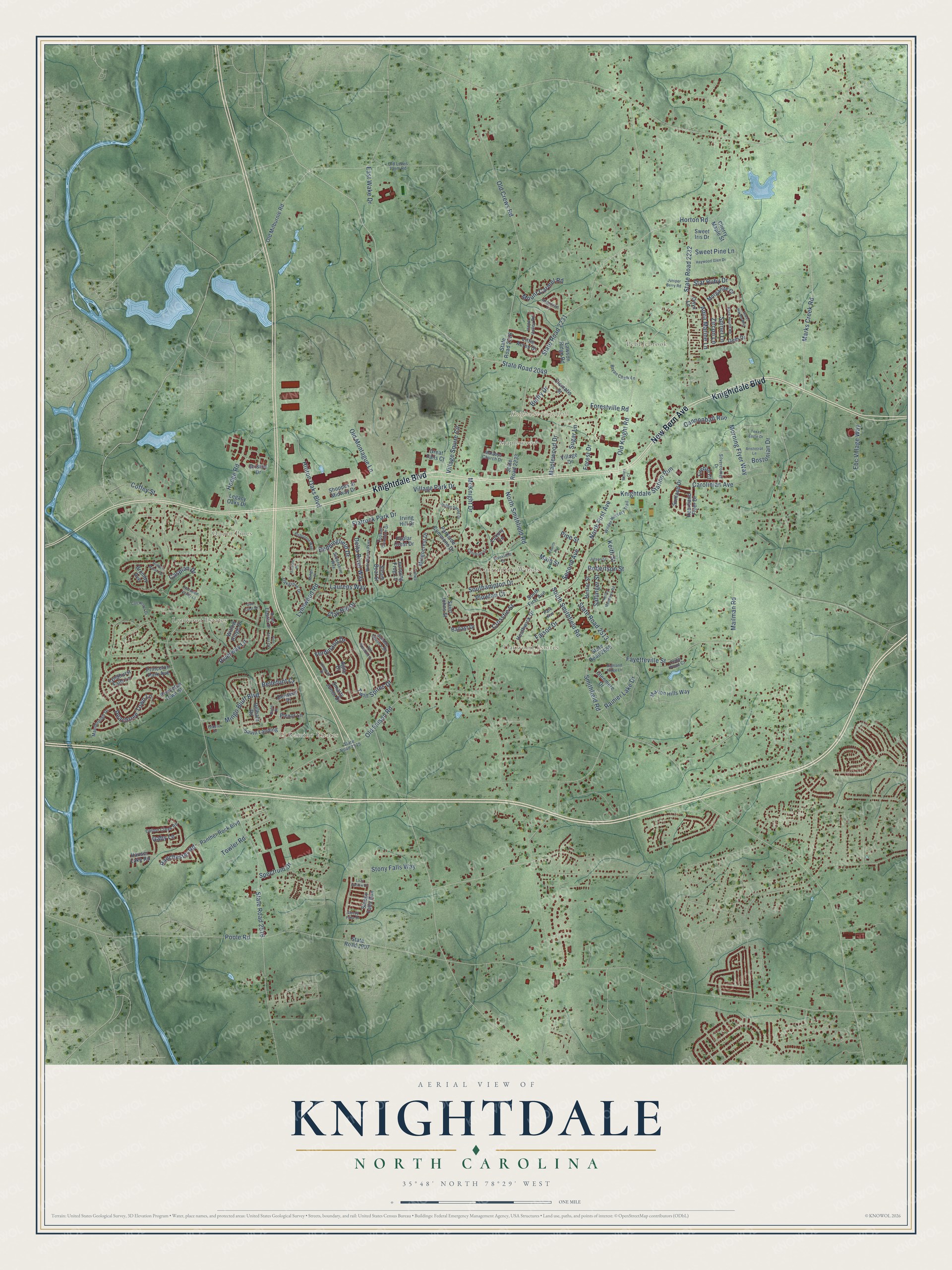
Knightdale, North Carolina Map Art
Building by building, with labeled streets and shaded relief.
12" x 18" Archival Matte Print
A Map of Home. A Work of Art.
Explore Knightdale, North Carolina from a whole new perspective. Created using aerial imagery and detailed geographic data, this map captures Knightdale building by building, with labeled streets, familiar landmarks, and shaded topographical relief that highlights the natural contours of the landscape.
Combining modern data with the timeless character of a vintage atlas, this map is just as interesting up close as it is beautiful on the wall. Whether you grew up in Knightdale, spent memorable years there, or call it home today, this unique map is a great way to celebrate a place that means something to you. Zoom in on the preview to look for your street, and then order a print to put your memories on the wall.
Three ways to hang it

Unframed archival matte, a black wood frame or a white wood frame.
Up close
Geography Worth Displaying
This map was created using accurate cartographic data and authoritative geographic sources, including the U.S. Geological Survey and the Census Bureau. The map brings together terrain, waterways, roads, and building detail. The majority of the streets are labeled, houses are accurately depicted, and the topography is derived from government sources. Combining local data with carefully composed color and shading leads to this beautifully detailed Knightdale artwork for your wall.
Rather than simply showing street outlines, we’ve included as many of the street names as we could reasonably fit on the map while keeping their names legible. Zoom in on the high resolution preview to see exactly what’s on the map. We truly set out to create a statement piece for anyone who loves Knightdale. So whether it’s for you, or a gift for someone you love, we hope this map of Knightdale brings back fond memories.
Read the story behind this map of Knightdale, North Carolina from 2026.

Find your street
Names on the Knightdale map
Every name below is printed on this map. Look for your street, your school, the park where you played, or the pond down the road.
Places and landmarks8
- Knightdale Town Hall
- El Camino Estates
- Oakwood Estates
- Pebblebrook
- Lynwood Estates
- Queen Pines
- Carrington Woods
- Maplewood
Streets and roads169
- Knightdale Boulevard
- New Bern Avenue
- State Road 2049
- North Smithfield Road
- South Smithfield Road
- Marks Creek Road
- Forestville Road
- Maplewood Drive
- State Road 2232
- Smithfield Road
- State Road 2231
- Hodge Road
- Laurens Way
- Lynnwood Road
- State Road 2516
- Old Knight Road
- Old Crews Road
- Fayetteville Street
- State Road 2513
- McKnight Drive
- Horton Road
- Mailman Road
- Stony Falls Way
- North First Avenue
- Carolinian Avenue
- Peachtree Town Lane
- Mingo Bluff Boulevard
- Village Squire Circle
- Flatrock Park Drive
- Morning Flyer Way
Show all 169 streets
- Hinton Oaks Boulevard
- Poole Road
- Beddingfield Drive
- Southampton Drive
- Robertson Street
- Bostonian Drive
- Twin Spires Drive
- Village Park Drive
- Second Avenue
- Ferdinand Drive
- Crosstie Street
- Old Faison Road
- Knightdale Station Run
- Clay Hill Drive
- Rainier Lake Drive
- Ebc Village Way
- Old Montague Lane
- Aqua Marine Lane
- Delta River Way
- Mount Carmel Road
- Bellefont Court
- Towler Road
- Spectrum Drive
- Cannonball Run
- Sallinger Street
- Main Street
- Spinel Lane
- Star Ruby Drive
- Riverway Lane
- Zircon Lane
- Faison Drive
- East Wake Drive
- Ranchester Road
- Sweet Pine Lane
- Caspian Drive
- Sugar Lane
- Plowlan Court
- Belfry Drive
- Keith Street
- Forest Drive
- Pine Street
- Gaby Lane
- Coffey Street
- South First Avenue
- Legacy Oaks Drive
- Old Milburnie Road
- State Road 2233
- State Road 2228
- State Road 1007
- Sleepy Falls Run
- Delham Road
- Parkside Commons Drive
- Princeton Town Street
- Plexor Lane
- Heathwick Drive
- Shoppes at Midway Drive
- Panther Rock Boulevard
- Mingocrest Drive
- Bristoe Drive
- Hester Street
- Cherry Maple Street
- Smarty Jones Drive
- Saint Johns Street
- Sunland Drive
- Lawson Ridge Road
- Princeton Park Avenue
- Poplar Crest Drive
- Marion Hills Way
- Glenmere Drive
- Gem Drive
- Village Drive
- Savin Landing
- Hauser Lake Road
- Clematis Street
- Willow Ridge Drive
- Morganite Court
- Heartland Flyer Drive
- Lyndhurst Falls Lane
- Onyx Lane
- Little Acres Drive
- Sweet Iris Drive
- Bromby Avenue
- Agile Drive
- State Road 2665
- Fireball Court
- Steam Boat Street
- Ballast Drive
- Luxury Lane
- Jumping Frog Lane
- Irving Hill Drive
- Derwent Place
- Great Falls Court
- Silvercomet Drive
- Sunday Silence Drive
- State Road 2515
- Park Avenue
- Manderleigh Drive
- Wilder Nursery Trail
- Bryan Chalk Lane
- Oakgrove Drive
- Cedar Pond Court
- Colton Creek Road
- Topsail Common Drive
- Silvershire Way
- Malabys Church Drive
- Hope Valley Road
- River Estates Drive
- Old Lewis Farm Road
- Hadel Place
- Wide Waters Parkway
- Kingman Drive
- Haywood Glen Drive
- Brookfield Drive
- Indian Spring Drive
- Kelley Meadows Road
- Fourth Avenue
- Highland Ridge Lane
- Hidden Manor Drive
- Redwood Valley Lane
- Oak Crest Drive
- Rock Hound Road
- Jewel Haven Way
- Old Rosebud Drive
- Federer Drive
- Costmary Lane
- Aristocrat Lane
- Bishopton Way
- Texas Eagle Drive
- Sleepy Falls Drive
- Jutson Street
- Colchester Drive
- Tarford Place
- Allendown Lane
- Juniper Berry Road
- Pine Acres Court
- Lazy Hollow Drive
- Mingo Place
- Tallula Lane
- Money Court
Names are listed as they appear on the printed map. Zoom into the product photos to find them.
About Knightdale, North Carolina
Knightdale is a town of 19,435 people in Wake County, east of Raleigh near the Neuse River. For many years the place was just a crossroads with a post office. Late in the 19th century, residents decided they wanted a real town, so landowner Henry Haywood Knight gave some of his land to the Norfolk and Southern Railroad Company to win a line with freight and passenger trains.
Knight died in 1904, and the tracks and depot arrived soon afterward, so the new town took his name. The railroad moved families in to run the line, and many of Knightdale's older houses were built for its workers. The first stationmaster's house still stands beside the tracks on Railroad Street. The North Carolina Legislature incorporated Knightdale on March 9, 1927, and Bennett L. Wall became its first mayor.
- John Hinton arrived in 1730John Hinton settled near the Neuse River, close to where Hodge Road now meets Old Faison Road. The colonial government made him justice of the peace for Craven County. When the Revolution came, he sided with the colonists and helped lead them at the Battle of Moore's Creek Bridge, the first Revolutionary War battle in North Carolina. He owned seven plantations here, and three survive: The Oaks, Midway and Beaver Dam.
- The downtown fire of 1940On February 7, 1940, fire broke out in the middle of town. Residents rushed to fight it, but they couldn't stop it until firefighters came from Raleigh with enough water. The blaze destroyed several businesses and homes, and the townspeople rebuilt their downtown. Knightdale installed a municipal water system in 1952.
- Movies on the bank wallAfter World War II, the drugstore, the bank and the barber shop on First Avenue were where people shopped and gathered. Residents often watched films projected onto the side of the old bank building, at the corner of First Avenue and Main Street. In the 1960s, most new businesses began to open along US 64 instead.
- A boom after 1990The Mingo Creek sewer outfall, added in the late 1980s, opened land south of US 64 to new neighborhoods like Planter's Walk, Parkside and Mingo Creek. Between 1990 and 2000 the town grew from 1,700 people to more than 6,000, the seventh fastest growth of any town in North Carolina. Knightdale elected its first woman mayor, Jeanne Milliken Bonds, in 2002.
- Frankie Muniz grew up hereThe television and film actor Frankie Muniz grew up in Knightdale. His first acting role was Tiny Tim, which he played in a stage version of the Dickens story A Christmas Carol three years running.
Keep exploring North Carolina
Knightdale is one of 952 North Carolina towns we've mapped. Every dot on the map is a print of its own.
The search covers every state, North Carolina first.
Near Knightdale
Order 2 or more town maps and save 10%. Shown in the size and finish you picked above, so they hang as a set.
- Wendell 12" x 18" / Archival Matte Print $39.99
- Raleigh 12" x 18" / Archival Matte Print $39.99
- Rolesville 12" x 18" / Archival Matte Print $39.99


More maps nearby: Clayton, Garner, Archer Lodge, Zebulon and Wake Forest.
The art of mapping a place
How This Map Was Made
Real places. Remarkable detail. Discover the layers that turn geographic data into a map of home.

The view from above
Aerial imagery reveals the character of the land: woodland, open fields, and the patterns of a place.

The shape of the land
Elevation data brings hills, valleys, and subtle changes in the landscape into view.

The details of home
Roads, waterways, and building footprints come together to make the map feel unmistakably local.

Geography becomes art
Considered color, shading, and typography bring the layers together in a map made for your wall.


Process illustrated with Mendon, Massachusetts. Aerial imagery: USDA NAIP. Terrain: USGS 3D Elevation Program. Map details and finished artwork: KNOWOL.
The Details
About This Print
Choose an archival matte print, or a black or white Ayous wood frame. The archival matte print is unframed.
Select your size and finish above to see the matching product image and price.
Materials & Craftsmanship
A contemporary map with the character of a classic atlas, printed on archival matte paper. Optional frames are made from Ayous wood.
Your printed map does not include the watermark shown in the full-map preview.
Shipping & Delivery
Free shipping within the United States. Every print is made to order in the USA.
Buying a gift? Add a note in your cart and we'll include it. We never put prices in the package.
Prints ship within 2 to 3 business days. Allow 7 to 10 days total from ordering for delivery. Timing may vary during holidays or periods of high order volume.
Read our shipping policy.
Returns and damaged prints
Each print is made to order. Change-of-mind refunds are not available after production.
If your print arrives damaged, misprinted or incorrect, contact support@knowol.com within 30 days of receiving it. Include your order number, photos and a description of the issue.
Read our full refund and replacement policy. For questions about your order, email support@knowol.com.