
Search for another town


Free U.S. delivery 7 to 10 days after you order
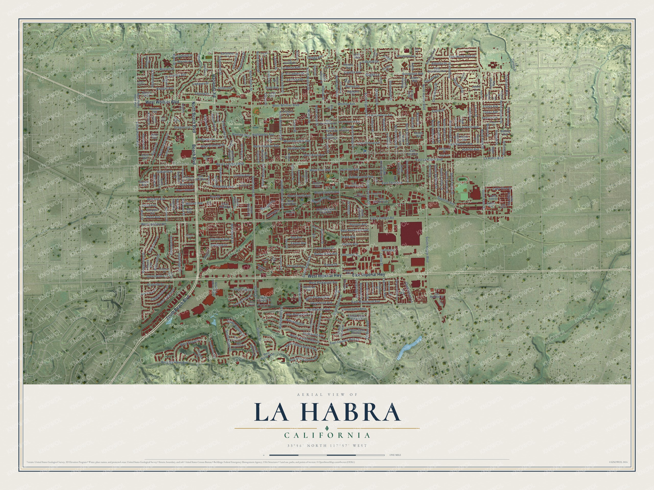
La Habra, California Map Art
Building by building, with labeled streets and shaded relief.
12" x 18" Archival Matte Print
A Map of Home. A Work of Art.
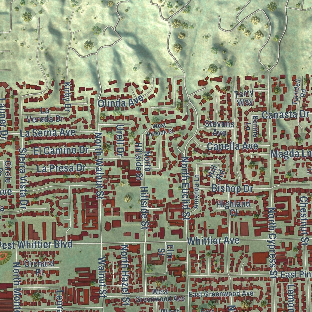
Explore La Habra, California from a whole new perspective. Created using aerial imagery and detailed geographic data, this map captures La Habra building by building, with labeled streets, familiar landmarks, and shaded topographical relief that highlights the natural contours of the landscape.
Combining modern data with the timeless character of a vintage atlas, this map is just as interesting up close as it is beautiful on the wall. Whether you grew up in La Habra, spent memorable years there, or call it home today, this unique map is a great way to celebrate a place that means something to you. Zoom in on the preview to look for your street, and then order a print to put your memories on the wall.
Three ways to hang it

Unframed archival matte, a black wood frame or a white wood frame.
Up close
Geography Worth Displaying
This map was created using accurate cartographic data and authoritative geographic sources, including the U.S. Geological Survey and the Census Bureau. The map brings together terrain, waterways, roads, and building detail. The majority of the streets are labeled, houses are accurately depicted, and the topography is derived from government sources. Combining local data with carefully composed color and shading leads to this beautifully detailed La Habra artwork for your wall.
Rather than simply showing street outlines, we’ve included as many of the street names as we could reasonably fit on the map while keeping their names legible. Zoom in on the high resolution preview to see exactly what’s on the map. We truly set out to create a statement piece for anyone who loves La Habra. So whether it’s for you, or a gift for someone you love, we hope this map of La Habra brings back fond memories.
Read the story behind this map of La Habra, California from 2026.

Find your street
Names on the La Habra map
Every name below is printed on this map. Look for your street, your school, the park where you played, or the pond down the road.
Places and landmarks5
- La Habra City Hall
- Des Moines
- La Bonita Park
- Portola Park
- Westridge Golf Club
Streets and roads361
- North Beach Boulevard
- West Whittier Boulevard
- Hacienda Road
- Beach Boulevard
- South Beach Boulevard
- West Imperial Highway
- East Imperial Highway
- West Lambert Road
- West La Habra Boulevard
- East Lambert Road
- East La Habra Boulevard
- North Harbor Boulevard
- North Palm Street
- Russell Street
- Randall Avenue
- North Fonda Street
- South Palm Street
- Hacienda Drive
- La Habra Boulevard
- Creek Lane
- Idaho Street
- South Idaho Street
- North Idaho Street
- South Harbor Boulevard
- North Euclid Street
- South Euclid Street
- West El Portal Drive
- South Marian Street
- Cheltenham Lane
- Sandlewood Avenue
Show all 361 streets
- Brass Lantern Drive
- Gwynwood Avenue
- Whittier Avenue
- East Francis Avenue
- South Walnut Street
- Valley Home Avenue
- West Nicklaus Avenue
- South Cypress Street
- East Stearns Avenue
- North Walnut Street
- North Cypress Street
- Walnut Street
- North Orange Street
- Brookdale Avenue
- Las Lomas Drive
- Ridgehaven Drive
- Buena Vista Avenue
- Gregory Lane
- West Erna Avenue
- Arbolita Drive
- Rigsby Street
- Heather Avenue
- West Heather Avenue
- South Monte Vista Street
- North Monte Vista Street
- Highlander Avenue
- La Serna Avenue
- Citrus Drive
- North Citrus Drive
- West Florence Avenue
- North Dexford Drive
- Brighton Street
- Story Avenue
- Gilbert Street
- Teakwood Avenue
- Wilshire Avenue
- Hillside Street
- Sturbridge Drive
- El Rancho Drive
- Sidon Avenue
- Keene Drive
- East Third Avenue
- Hillandale Avenue
- West First Avenue
- Sierra Vista Drive
- Lindauer Drive
- East Montwood Avenue
- Oakland Drive
- Gordon Avenue
- West Snead Street
- Macy Street
- Lorella Avenue
- Lemon Street
- Kirkwood Lane
- Mariposa Street
- South Fonda Street
- East North Hills Drive
- East Second Avenue
- East First Avenue
- Chestnut Street
- North College Street
- North Sunset Street
- Ryan Avenue
- Whitebook Drive
- North Hazel Street
- Juanita Street
- West Country Hills Drive
- West Pebble Beach Avenue
- West Parkwood Avenue
- South Dexter Street
- Schoolwood Drive
- Hodson Avenue
- Sheffield Drive
- Merced Avenue
- Kinley Street
- South Colfax Street
- Lois Street
- North Colfax Street
- East Country Hills Drive
- Bishop Drive
- La Presa Drive
- South Bedford Street
- South Hagen Street
- North Verona Street
- Greenbrier Lane
- Carol Street
- Cll Don Juan
- Briercliff Drive
- Canfield Drive
- Concourse Street
- North Dexter Street
- La Plaza Drive
- North Bedford Street
- Edgemont Street
- Grayville Drive
- Lakeview Avenue
- Pine Drive
- Sharpless Street
- Holgate Street
- Laguna Drive
- Alpine Street
- Superior Avenue
- Cobblestone Road
- West Olive Avenue
- Olinda Avenue
- Greenview Drive
- Clifton Street
- Shelburne Street
- Pacific Avenue
- West Fourth Avenue
- Grace Avenue
- East Rosecrest Avenue
- Durham Street
- West Electric Avenue
- Leora Street
- Leslie Street
- Maryglen Lane
- Almondwood Street
- Lemon Tree Drive
- Parsons Street
- South Runyan Street
- Olive Tree Drive
- Capella Avenue
- Tropicana Way
- West Patwood Drive
- Burwood Street
- Laura Street
- Rye Avenue
- El Camino Drive
- Lake View Drive
- Devonshire Lane
- Glenhaven Drive
- Hillcrest Street
- Maple Street
- Wall Street
- Penmar Avenue
- Stonewood Street
- Deanna Street
- Elmsford Avenue
- Hanline Way
- Palermo Way
- Canasta Drive
- Essex Drive
- Ironwood Street
- Exeter Avenue
- Frantz Avenue
- Topaz Avenue
- Longridge Drive
- Lime Street
- Roscoe Street
- Wilson Street
- Warne Street
- Carmela Lane
- Launer Drive
- Marie Street
- Union Avenue
- Ward Street
- Magda Lane
- Kern Street
- Urell Drive
- Eastpark Drive
- North Valley Home Avenue
- Woodcrest Avenue
- East Erna Avenue
- East Pinehurst Avenue
- West Saint Andrews Avenue
- North Hillside Street
- East Florence Avenue
- West Mountain View Avenue
- Dorwood Avenue
- Cll Don Guillermo
- North Valencia Street
- Verona Street
- West Wedgewood Lane
- Donnaglen Lane
- Kirby Drive
- Mikinda Avenue
- Silliker Avenue
- Avenue Santa Dorotea
- Virginia Street
- North Marian Street
- Avenue Santa Anita
- Cedarwood Drive
- Chantry Drive
- Silver Maple Drive
- Ramona Avenue
- South Dexford Drive
- Raymond Street
- Foxdale Avenue
- San Jose Avenue
- Martinez Drive
- Linda Avenue
- El Dorado Avenue
- La Casa Avenue
- Rockinghorse Lane
- Sansinena Lane
- Park Industrial Drive
- South Valencia Street
- South College Street
- South McPherson Avenue
- Derry Street
- Avenue Santa Catalina
- Glencliff Street
- South Watson Street
- East Brookdale Avenue
- Antoinette Drive
- Willow Street
- Valwood Street
- South La Habra Hills Drive
- Foundation Avenue
- North El Portal Drive
- Roanoke Street
- Campbell Avenue
- Chesham Avenue
- Mission Street
- West Toledo Place
- Meadow Lark Street
- North Ellie Street
- South Floyd Court
- Baldwin Street
- Roddy Drive
- Lake Ridge Way
- West Rose Avenue
- Circle Drive
- South Olive Avenue
- Vallejo Street
- Ridgeway Lane
- West Risner Way
- Sharon Way
- La Canada Drive
- Baja Avenue
- Las Riendas Drive
- Terry Way
- West Country Terrace
- West Francis Avenue
- Flamingo Way
- Industry Avenue
- La Vereda Drive
- Knudson Street
- Emery Avenue
- Chinchilla Street
- Sarazen Court
- Lorawood Street
- Walling Avenue
- Orchard Place
- Mateo Avenue
- Norma Street
- David Avenue
- South Petunia Street
- Jamie Avenue
- West Fifth Avenue
- Stanford Street
- Auburn Way
- Lake Side Drive
- Stevens Avenue
- Ronwood Avenue
- Highland Court
- Portola Avenue
- South Poplar Street
- Wade Street
- Ember Lane
- Kerner Way
- Vecino Street
- Joan Street
- Concord Way
- Cheri Drive
- Jennie Lane
- Sonora Place
- Stanton Avenue
- Bond Avenue
- Roddy Way
- Linden Lane
- Hill Road
- Elm Street
- West Greenwood Avenue
- North McPherson Street
- East Rose Avenue
- East Greenwood Avenue
- East Bridenbecker Avenue
- Redcoach Lane
- Coachwood Street
- Village Drive
- Summershade Drive
- Lydia Street
- Farrington Drive
- Orangewood Street
- Turndell Road
- West Harrison Avenue
- Amanda Lane
- Marlei Road
- Granada Drive
- East Fourth Avenue
- Lynwood Street
- Painter Street
- Cambridge Drive
- Rain Tree Drive
- Estate Drive
- El Rey Drive
- Dover Drive
- Marin Street
- Bonnie Lane
- Palm Street
- Norte Street
- Park Avenue
- Alto Lane
- Rye Circle
- North Galen Drive
- West Hillandale Avenue
- Nantucket Street
- Susanglen Circle
- West San Jose Avenue
- Commercial Way
- Vaquero Avenue
- South Cajon Drive
- West Player Avenue
- West Country Vw
- Mardina Way
- Carpenter Street
- Ladera Terrace
- Lake Glen Drive
- West Hillside Street
- Gerry Street
- Entrada Drive
- Victoria Way
- Shady Valley Lane
- Walker Lane
- Elmcroft Circle
- Bright Street
- Inola Court
- Fern Way
- Oak Way
Names are listed as they appear on the printed map. Zoom into the product photos to find them.
About La Habra, California
La Habra is a city of 63,097 people at the northwestern edge of Orange County. Its name is an old spelling of la abra, Spanish for "the opening," and it refers to a gap in the hills that lies north of town. Spanish explorers with the Portola expedition found that pass and used it on July 30, 1769. In 1839 Mariano Reyes Roldan received 6,698 acres here and called his land Rancho Cañada de La Habra, and Abel Stearns bought the rancho in the 1860s.
The town was founded in 1896, and two years later its first post office opened in one corner of Coy's Store, where Central and Euclid Street met. La Habra became a city on January 20, 1925, with 3,000 people. It formed a police force the next year, built its first fire station in 1930 and finished its original City Hall in 1935. By 1950 the city had nearly 5,000 residents.
“West Coyote was active from 1903 to 1996, and it was one of the foundations of the oil industry in Southern California.”
- Avocado center by 1928By 1928 La Habra was the largest avocado center in Southern California. Just to the north, in La Habra Heights, Rudolph Hass planted the mother tree of the 'Hass' avocado in the 1920s, and its fruit became one of the most popular avocados in the world. The original tree died of root rot in 2002.
- Nixon's law office in 1938In 1938 a young Richard Nixon started his law practice in La Habra, long before he was elected president of the United States.
- The monkeys of Monkey IslandA rancher once dug a lake here with an island in the middle, called Monkey Island, where he let feral monkeys run loose. In the 1970s a shopping plaza and a post office went up where the lake had been.
- A race named for the cityThe La Habra Stakes, a race for thoroughbreds, has been run at Santa Anita Park since 1973 and carries the city's name.
- Hometown of championsAnn Meyers, an Olympian, became the first player picked for the U.S. national basketball team while still in high school. Cruz Reynoso, also from La Habra, became the first Latino justice on the California Supreme Court. Norma Zimmer, the "Champagne Lady" of the Lawrence Welk Show, served as the city's honorary mayor in 1975.
Keep exploring California
La Habra is one of 1,990 California towns we've mapped. Every dot on the map is a print of its own.
The search covers every state, California first.
Near La Habra
Order 2 or more town maps and save 10%. Shown in the size and finish you picked above, so they hang as a set.
- East La Mirada 12" x 18" / Archival Matte Print $39.99
- East Whittier 12" x 18" / Archival Matte Print $39.99
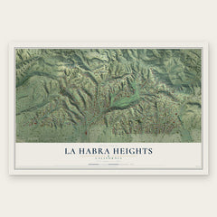
- La Habra Heights 12" x 18" / Archival Matte Print $39.99
More maps nearby: Fullerton, La Mirada, South Whittier, Rowland Heights and Whittier.
The art of mapping a place
How This Map Was Made
Real places. Remarkable detail. Discover the layers that turn geographic data into a map of home.

The view from above
Aerial imagery reveals the character of the land: woodland, open fields, and the patterns of a place.

The shape of the land
Elevation data brings hills, valleys, and subtle changes in the landscape into view.

The details of home
Roads, waterways, and building footprints come together to make the map feel unmistakably local.

Geography becomes art
Considered color, shading, and typography bring the layers together in a map made for your wall.


Process illustrated with Mendon, Massachusetts. Aerial imagery: USDA NAIP. Terrain: USGS 3D Elevation Program. Map details and finished artwork: KNOWOL.
The Details
About This Print
Choose an archival matte print, or a black or white Ayous wood frame. The archival matte print is unframed.
Select your size and finish above to see the matching product image and price.
Materials & Craftsmanship
A contemporary map with the character of a classic atlas, printed on archival matte paper. Optional frames are made from Ayous wood.
Your printed map does not include the watermark shown in the full-map preview.
Shipping & Delivery
Free shipping within the United States. Every print is made to order in the USA.
Buying a gift? Add a note in your cart and we'll include it. We never put prices in the package.
Prints ship within 2 to 3 business days. Allow 7 to 10 days total from ordering for delivery. Timing may vary during holidays or periods of high order volume.
Read our shipping policy.
Returns and damaged prints
Each print is made to order. Change-of-mind refunds are not available after production.
If your print arrives damaged, misprinted or incorrect, contact support@knowol.com within 30 days of receiving it. Include your order number, photos and a description of the issue.
Read our full refund and replacement policy. For questions about your order, email support@knowol.com.