
Search for another town


Free U.S. delivery 7 to 10 days after you order
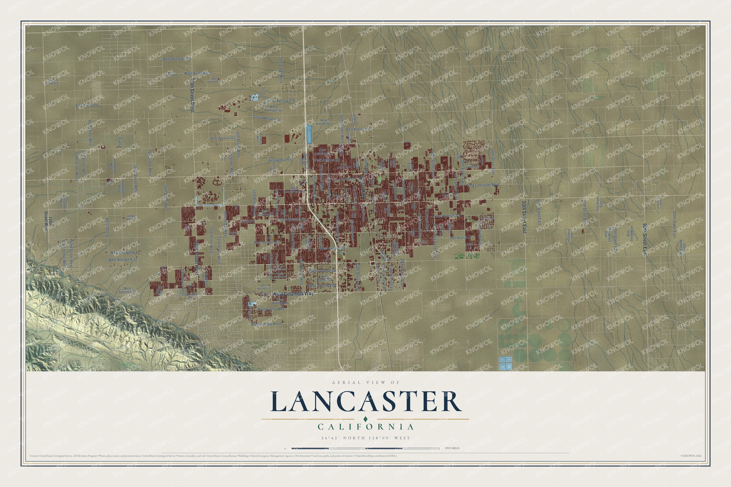
Lancaster, California Map Art
Building by building, with labeled streets and shaded relief.
12" x 18" Archival Matte Print
A Map of Home. A Work of Art.
Explore Lancaster, California from a whole new perspective. Created using aerial imagery and detailed geographic data, this map captures Lancaster building by building, with labeled streets, familiar landmarks, and shaded topographical relief that highlights the natural contours of the landscape.
Combining modern data with the timeless character of a vintage atlas, this map is just as interesting up close as it is beautiful on the wall. Whether you grew up in Lancaster, spent memorable years there, or call it home today, this unique map is a great way to celebrate a place that means something to you. Zoom in on the preview to look for your street, and then order a print to put your memories on the wall.
Three ways to hang it

Unframed archival matte, a black wood frame or a white wood frame.
Up close
Geography Worth Displaying
This map was created using accurate cartographic data and authoritative geographic sources, including the U.S. Geological Survey and the Census Bureau. The map brings together terrain, waterways, roads, and building detail. The majority of the streets are labeled, houses are accurately depicted, and the topography is derived from government sources. Combining local data with carefully composed color and shading leads to this beautifully detailed Lancaster artwork for your wall.
Rather than simply showing street outlines, we’ve included as many of the street names as we could reasonably fit on the map while keeping their names legible. Zoom in on the high resolution preview to see exactly what’s on the map. We truly set out to create a statement piece for anyone who loves Lancaster. So whether it’s for you, or a gift for someone you love, we hope this map of Lancaster brings back fond memories.
Read the story behind this map of Lancaster, California from 2026.

Find your street
Names on the Lancaster map
Every name below is printed on this map. Look for your street, your school, the park where you played, or the pond down the road.
Places and landmarks1
- Sunrise
Streets and roads164
- 60th Street West
- Sierra Highway
- West Columbia Way
- 50th Street East
- 90th Street East
- 30th Street West
- 40th Street West
- 20th Street West
- 15th Street West
- West Avenue J8
- East Avenue J-8
- Andale Avenue
- West Avenue K8
- 30th Street East
- 70th Street West
- Tenth Street West
- 100th Street West
- 25th Street West
- West Avenue East
- East Lancaster Boulevard
- Challenger Way
- 45th Street West
- Division Street
- 50th Street West
- Fifth Street East
- 55th Street West
- 40th Street East
- 80th Street West
- 32nd Street West
- 15th Street East
Show all 164 streets
- 35th Street West
- 105th Street West
- West Avenue L4
- 47th Street West
- 27th Street West
- Twelfth Street West
- 35th Street East
- West Avenue H8
- 17th Street West
- 17th Street East
- Third Street East
- 65th Street West
- 20th Street East
- Eighth Street East
- West Avenue K-8
- 52nd Street West
- Elm Avenue
- Beech Avenue
- West Avenue K4
- West Avenue L12
- 80th Street East
- 27th Street East
- Trevor Avenue
- 97th Street West
- Gadsden Avenue
- West Avenue F-8
- West Avenue K-12
- West Avenue North
- 70th Street East
- North 20th Street East
- West Avenue E-8
- 95th Street West
- West Avenue M8
- 55th Street East
- Great Western Drive
- 103rd Street West
- 75th Street West
- 100th Street East
- Sixth Street West
- West 90th Street
- 85th Street
- 110th Street West
- Cedar Avenue
- Fenhold Street
- East Avenue K-4
- West Avenue G-4
- Vahan Court
- West Lancaster Boulevard
- Seventh Street East
- 42nd Street West
- West Avenue J4
- West Avenue H-8
- 22nd Street West
- 57th Street West
- West Jackman Street
- 23rd Street West
- Fig Avenue
- West Avenue L8
- Kingtree Avenue
- 85th Street West
- West Avenue G-8
- Genoa Avenue
- Foxton Avenue
- Rodin Avenue
- Fenner Avenue
- Bus Center Parkway
- 75th Street East
- Gingham Avenue
- West Avenue H4
- 85th Street East
- West Avenue G12
- Valley Line Road
- West Avenue F-10
- West Avenue F8
- 102nd Street East
- 87th Street West
- Shad Street
- Lively Avenue
- West Avenue L-15
- Valley Vista Drive
- Yaffa Street
- 105 Street West
- Redwood Avenue
- West Avenue M4
- 77th Street East
- 12 Street East
- East Third Street
- Patti Lane
- 37th Street West
- Norberry Street
- 25th Street East
- 36th Street West
- Fern Avenue
- Columbia Way
- West Avenue L6
- West Avenue L2
- West Avenue E8
- Spice Street
- 22nd Street East
- West Avenue H12
- East Avenue H14
- Jade Court
- West Avenue L-12
- West Avenue E-11
- 95th Street East
- 65th Street East
- West Avenue E-12
- Hodge Mahal Drive
- Sachs Drive
- Tali Street
- Lyric Avenue
- Paula
- 18th Street West
- North Lane
- 50th Stw
- East Nugent Street
- 33rd Street West
- Twelfth Street East
- Calston Avenue
- 28th Street East
- Seventh Street West
- Telephone Line Svc Road
- Yew Street
- Tahoe Way
- Mall Loop Road
- Alexo Drive
- Shiloh Lane
- Robinson Drive
- Camino Vis
- West Dale Drive
- Cinema Avenue
- Azalea Drive
- Devyn Lane
- Forry Court
Names are listed as they appear on the printed map. Zoom into the product photos to find them.
About Lancaster, California
Lancaster is a city of 173,516 people in Los Angeles County, on the Mojave Desert's western side in the Antelope Valley. Paiute people lived in the valley when Europeans first arrived, and it sat at the center of trade routes that ran to the coast, the Central Valley, the Great Basin and Arizona's pueblos. The town began with the Southern Pacific Railroad, which finished its line across the valley between San Francisco and Los Angeles in 1876 and put a station and a water stop for its engines where downtown stands now.
Train passengers and promotional pamphlets drew settlers, and some of the first were Scots. In 1884 Moses Langley Wicks bought land from the railroad at $2.50 an acre and laid out streets and lots, and by September he was selling 160-acre tracts for $6 an acre. By 1890 farmers were raising wheat and barley on thousands of acres. Then a drought that started in 1894 lasted ten years, closing businesses and driving cattle north. Lancaster survived, and when it incorporated in 1977 it had 37,000 people.
“A newspaper was established at Lancaster by M. L. Wicks in 1884-85, after which the community grew rapidly and was well advertised through the medium of the local paper.”
- The first solar-home ruleNo American city had required solar panels on every new home until Lancaster passed such a rule in March 2013, and the rule took effect in January 2014. City leaders had set out to make Lancaster the nation's first Net-Zero city, producing more clean energy than it uses, and City Hall, local schools and the minor league ballpark run on solar power.
- A high school in 1912Antelope Valley High School opened in 1912, so students from the growing valley no longer had to move to faraway cities to study. It was home to California's first high school dormitory system.
- Electric buses since 2013After Mayor R. Rex Parris led a trade trip to China in 2010, the Chinese firm BYD chose Lancaster for its American factories. In May 2013 it announced a 120,000-square-foot electric bus plant and a separate 44,000-square-foot battery plant here, and by April 2019 the Lancaster plant had built over 300 electric buses for the United States and Canada.
- The Western Hotel of 1876The Western Hotel, built in 1876, is the oldest building still standing in Lancaster. It opened as a museum in 1992 under the California Historic Site program.
Keep exploring California
Lancaster is one of 1,990 California towns we've mapped. Every dot on the map is a print of its own.
The search covers every state, California first.
Near Lancaster
Order 2 or more town maps and save 10%. Shown in the size and finish you picked above, so they hang as a set.
- Quartz Hill 12" x 18" / Archival Matte Print $39.99
- Del Sur 12" x 18" / Archival Matte Print $39.99
- Desert View Highlands 12" x 18" / Archival Matte Print $39.99


More maps nearby: Palmdale, Leona Valley, Elizabeth Lake, Rosamond and Acton.
The art of mapping a place
How This Map Was Made
Real places. Remarkable detail. Discover the layers that turn geographic data into a map of home.

The view from above
Aerial imagery reveals the character of the land: woodland, open fields, and the patterns of a place.

The shape of the land
Elevation data brings hills, valleys, and subtle changes in the landscape into view.

The details of home
Roads, waterways, and building footprints come together to make the map feel unmistakably local.

Geography becomes art
Considered color, shading, and typography bring the layers together in a map made for your wall.


Process illustrated with Mendon, Massachusetts. Aerial imagery: USDA NAIP. Terrain: USGS 3D Elevation Program. Map details and finished artwork: KNOWOL.
The Details
About This Print
Choose an archival matte print, or a black or white Ayous wood frame. The archival matte print is unframed.
Select your size and finish above to see the matching product image and price.
Materials & Craftsmanship
A contemporary map with the character of a classic atlas, printed on archival matte paper. Optional frames are made from Ayous wood.
Your printed map does not include the watermark shown in the full-map preview.
Shipping & Delivery
Free shipping within the United States. Every print is made to order in the USA.
Buying a gift? Add a note in your cart and we'll include it. We never put prices in the package.
Prints ship within 2 to 3 business days. Allow 7 to 10 days total from ordering for delivery. Timing may vary during holidays or periods of high order volume.
Read our shipping policy.
Returns and damaged prints
Each print is made to order. Change-of-mind refunds are not available after production.
If your print arrives damaged, misprinted or incorrect, contact support@knowol.com within 30 days of receiving it. Include your order number, photos and a description of the issue.
Read our full refund and replacement policy. For questions about your order, email support@knowol.com.