
Search for another town


Free U.S. delivery 7 to 10 days after you order
Palmdale, California Map Art
Building by building, with labeled streets and shaded relief.
12" x 18" Archival Matte Print
A Map of Home. A Work of Art.
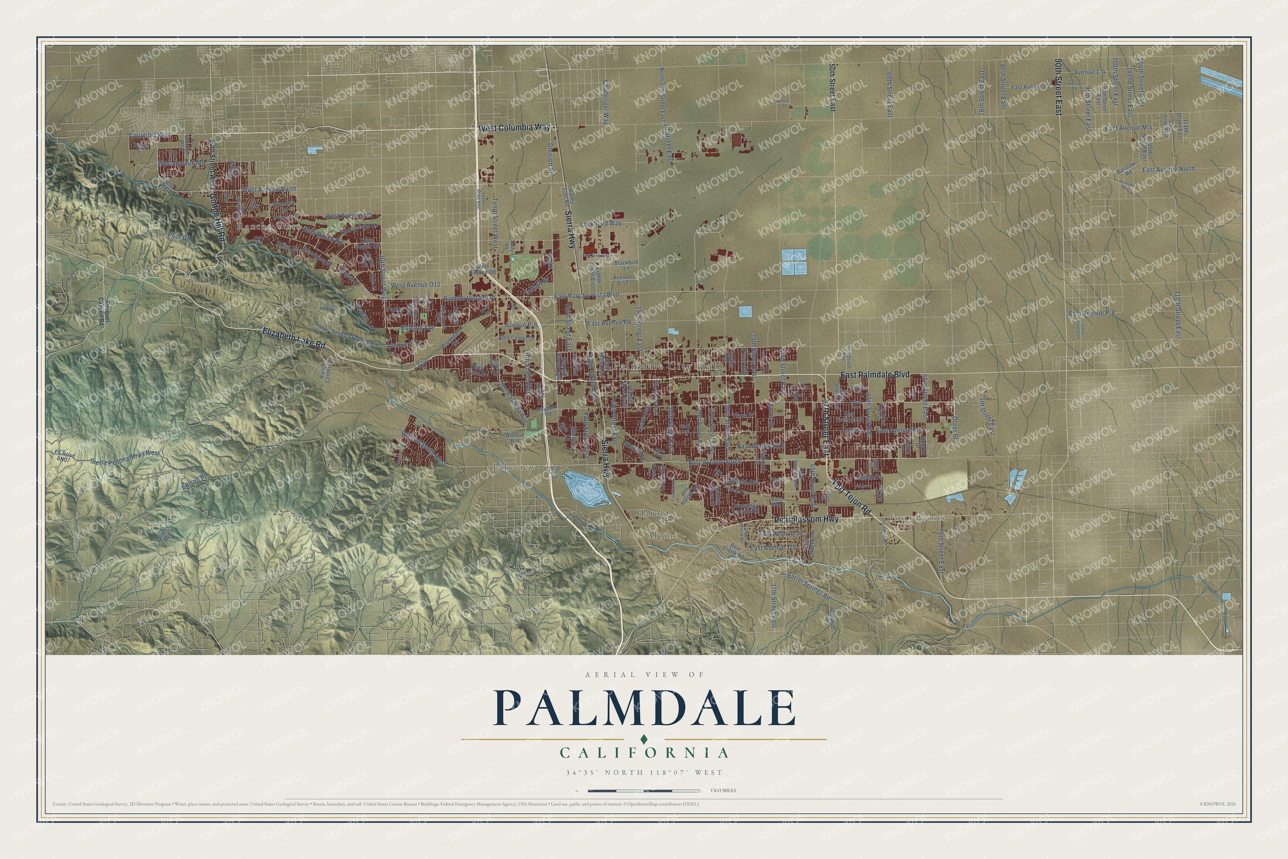
Explore Palmdale, California from a whole new perspective. Created using aerial imagery and detailed geographic data, this map captures Palmdale building by building, with labeled streets, familiar landmarks, and shaded topographical relief that highlights the natural contours of the landscape.
Combining modern data with the timeless character of a vintage atlas, this map is just as interesting up close as it is beautiful on the wall. Whether you grew up in Palmdale, spent memorable years there, or call it home today, this unique map is a great way to celebrate a place that means something to you. Zoom in on the preview to look for your street, and then order a print to put your memories on the wall.
Three ways to hang it

Unframed archival matte, a black wood frame or a white wood frame.
Up close
Geography Worth Displaying
This map was created using accurate cartographic data and authoritative geographic sources, including the U.S. Geological Survey and the Census Bureau. The map brings together terrain, waterways, roads, and building detail. The majority of the streets are labeled, houses are accurately depicted, and the topography is derived from government sources. Combining local data with carefully composed color and shading leads to this beautifully detailed Palmdale artwork for your wall.
Rather than simply showing street outlines, we’ve included as many of the street names as we could reasonably fit on the map while keeping their names legible. Zoom in on the high resolution preview to see exactly what’s on the map. We truly set out to create a statement piece for anyone who loves Palmdale. So whether it’s for you, or a gift for someone you love, we hope this map of Palmdale brings back fond memories.
Read the story behind this map of Palmdale, California from 2026.

Find your street
Names on the Palmdale map
Every name below is printed on this map. Look for your street, your school, the park where you played, or the pond down the road.
Places and landmarks7
- Palmdale City Hall
- Four Points
- Pearland
- Rancho Vista
- Alpine
- Lakeview
- Harold
Streets and roads183
- East Palmdale Boulevard
- Elizabeth Lake Road
- 47th Street East
- West Columbia Way
- Fort Tejon Road
- Godde Hill Road
- Sierra Highway
- Pearblossom Highway
- 90th Street East
- East Avenue South
- Division Street
- Rancho Vista Boulevard
- 70th Street East
- West Avenue North
- Tierra Subida Avenue
- Columbia Way
- 35th Street East
- 30th Street West
- Bulldog Avenue
- Avenue P-8
- Lockheed Way
- Avenue South West
- East Avenue R-8
- 40th Street East
- Tenth Street East
- 110th Street East
- 100th Street East
- Tenth Street West
- 30th Street East
- 37th Street East
Show all 183 streets
- East Avenue R12
- 25th Street East
- 15th Street East
- 45th Street East
- Fifth Street East
- Sierra Pellona Mtwy West
- 102nd Street East
- 60th Street East
- East Rancho Vista Boulevard
- Barrel Springs Road
- 75th Street East
- Joshua Ranch Road
- 20th Street East
- Third Street East
- 55th Street East
- Edison Road
- Sixth Street East
- Poor Road
- 27th Street East
- East Avenue North
- 80th Street East
- Fifth Street West
- West Avenue N8
- East Avenue M-4
- West Avenue M8
- East Avenue T-8
- 95th Street East
- West Avenue O12
- East Avenue P8
- 65th Street East
- East Avenue P-8
- Bolz Ranch Road
- Fairfield Avenue
- 76th Street East
- Avenue L-4
- Challenger Way
- Dorer Street
- East Avenue T4
- 20 Street East
- Essex Drive
- 104th Street East
- Fantasy Street
- Brisa Drive
- Pond Avenue
- Avenue P-12
- Beacon Lane
- Zinnia Street
- Janus Drive
- 50th Street East
- 60th Street West
- Agena Road
- Valley Line Road
- 42nd Street East
- Twelfth Street East
- 17th Street East
- Sungate Drive
- 105th Street East
- 25th Street West
- Ninth Street East
- Spanish Broom Drive
- Eighth Street East
- Date Palm Drive
- 43rd Street East
- Katrina Place
- Grandview Drive
- North 20th Street East
- Rockie Lane
- East Avenue L-8
- Town Center Drive
- East Avenue R4
- Ranch Center Drive
- Frontier Avenue
- Club Rancho Drive
- Lasker Avenue
- Old Harold Road
- Second Street East
- 97th Street East
- Paxton Avenue
- Barstow Road
- Auto Center Drive
- Bear Creek Road
- Rayburn Road
- Vicker Way
- Conestoga Canyon Road
- Ritter Mtwy
- 111th Street East
- Dunbar Street
- Riverock Lane
- Sheffield Drive
- Brookdale Road
- Avenue O-12
- Blackbird Lane
- West Avenue O8
- Siderno Drive
- Dawson Drive
- Almond Avenue
- Viana Drive
- Avenue R-8
- Kimberly Lane
- Alder Street
- Cll Grillo
- Dana Drive
- Becky Lane
- Jody Lane
- Noll Drive
- Bouquet Canyon Road
- 65th Street West
- 55th Street West
- 57th Street East
- Adobe Drive
- 20th Street West
- Landon Avenue
- 51st Street East
- Fourth Street East
- Opal Avenue
- Firethorn Street
- Jojoba Terrace
- Avenue N-8
- Pine Valley Court
- Desert Flower Drive
- Monaco Lane
- 108th Street East
- San Mateo Avenue
- Rose Street
- Carolyn Drive
- Dixie Drive
- Guita Court
- Knoll Drive
- Napa Way
- Mark Avenue
- East Avenue Q11
- 32nd Street East
- Avenue L-8
- Eliopulos Ranch Drive
- Twelfth Street West
- Parkwood Drive
- Sunburst Drive
- 22nd Street West
- Myrtle Street
- Olive Drive
- East Avenue O-5
- 92nd Street East
- Cheseboro Road
- Pioneer Drive
- Gable View Street
- Claro Way
- Lowes Drive
- Casa Verde Drive
- Saddle Circle
- Antelope Highway
- Avenue L-12
- Erwin Drive
- Port Avenue
Names are listed as they appear on the printed map. Zoom into the product photos to find them.
About Palmdale, California
Palmdale is a city of 169,450 people in Los Angeles County, in the Antelope Valley north of the San Gabriel Mountains. On April 20, 1886, Lutheran settlers from the Midwest, mostly of German and Swiss descent, founded a village here called Palmenthal, German for Palm Valley. They named it for the Joshua trees, which some people then called yucca palms. A post office opened on June 17, 1888, and made the village official.
Few of the settlers knew how to farm in the desert, and when the drought years came, most of them gave up. By 1899 just one family was left in the old village. The others moved with the post office nearer the Southern Pacific tracks, and the new community, renamed Palmdale, grew up where the civic center stands now. Palmdale incorporated on August 24, 1962, ahead of every other community in the Antelope Valley.
“Palmdale was one of a dozen socialist colonies founded in Antelope Valley between 1883 and 1914.”
- Water arrives in 1913Water was scarce as the town grew, until William Mulholland finished the Los Angeles Aqueduct on November 5, 1913, carrying water from the Owens Valley. Apples, pears and alfalfa soon grew in plenty. To irrigate the farms, builders put up the Harold Reservoir and the Little Rock Dam in 1924, and that reservoir is now Lake Palmdale.
- A newspaper and a highwayThe Palmdale Post, the town's first newspaper, came out in 1915 and is now the Antelope Valley Press. In 1921 the Mint Canyon/Lancaster Road gave Palmdale its first major road for cars to Los Angeles, and farming boomed. It later became U.S. Route 6 and is now Sierra Highway.
- Aerospace since 1952The federal government bought Palmdale Airport in 1952 and made it Air Force Plant 42, a place to build and test aircraft. Lockheed opened a plant there in 1953, and aerospace replaced farming as the main source of jobs. Because so many military aircraft were built here, Palmdale has been called the "Aerospace Capital of America."
- What's left of PalmenthalThe old Palmdale Pioneer cemetery, at Avenue S and 20th Street East, and the old schoolhouse, now moved to McAdam Park, are the last traces of Palmenthal and nearby Harold. The city bought and restored the cemetery for a future historical park.
Keep exploring California
Palmdale is one of 1,990 California towns we've mapped. Every dot on the map is a print of its own.
The search covers every state, California first.
Near Palmdale
Order 2 or more town maps and save 10%. Shown in the size and finish you picked above, so they hang as a set.
- Desert View Highlands 12" x 18" / Archival Matte Print $39.99
- Quartz Hill 12" x 18" / Archival Matte Print $39.99
- Acton 12" x 18" / Archival Matte Print $39.99


More maps nearby: Lancaster, Littlerock, Sun Village, Leona Valley and Del Sur.
The art of mapping a place
How This Map Was Made
Real places. Remarkable detail. Discover the layers that turn geographic data into a map of home.

The view from above
Aerial imagery reveals the character of the land: woodland, open fields, and the patterns of a place.

The shape of the land
Elevation data brings hills, valleys, and subtle changes in the landscape into view.

The details of home
Roads, waterways, and building footprints come together to make the map feel unmistakably local.

Geography becomes art
Considered color, shading, and typography bring the layers together in a map made for your wall.


Process illustrated with Mendon, Massachusetts. Aerial imagery: USDA NAIP. Terrain: USGS 3D Elevation Program. Map details and finished artwork: KNOWOL.
The Details
About This Print
Choose an archival matte print, or a black or white Ayous wood frame. The archival matte print is unframed.
Select your size and finish above to see the matching product image and price.
Materials & Craftsmanship
A contemporary map with the character of a classic atlas, printed on archival matte paper. Optional frames are made from Ayous wood.
Your printed map does not include the watermark shown in the full-map preview.
Shipping & Delivery
Free shipping within the United States. Every print is made to order in the USA.
Buying a gift? Add a note in your cart and we'll include it. We never put prices in the package.
Prints ship within 2 to 3 business days. Allow 7 to 10 days total from ordering for delivery. Timing may vary during holidays or periods of high order volume.
Read our shipping policy.
Returns and damaged prints
Each print is made to order. Change-of-mind refunds are not available after production.
If your print arrives damaged, misprinted or incorrect, contact support@knowol.com within 30 days of receiving it. Include your order number, photos and a description of the issue.
Read our full refund and replacement policy. For questions about your order, email support@knowol.com.