
Search for another town


Free U.S. delivery 7 to 10 days after you order
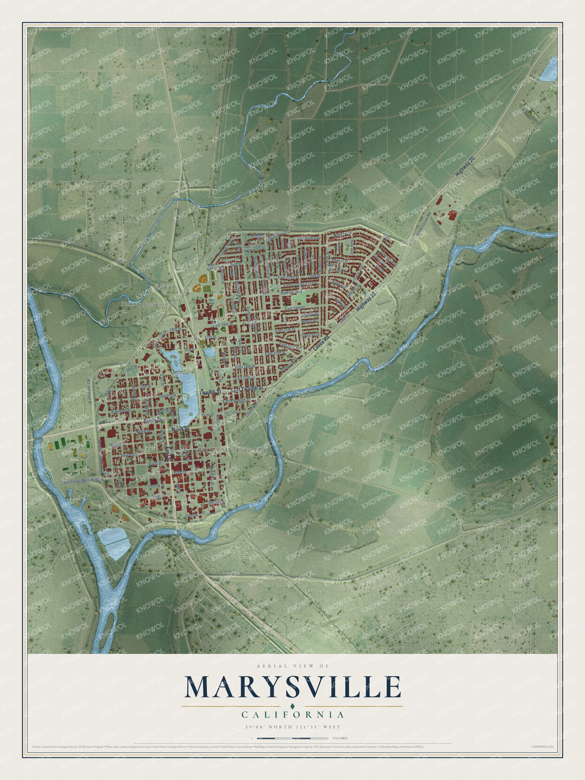
Marysville, California Map Art
Building by building, with labeled streets and shaded relief.
12" x 18" Archival Matte Print
A Map of Home. A Work of Art.
Explore Marysville, California from a whole new perspective. Created using aerial imagery and detailed geographic data, this map captures Marysville building by building, with labeled streets, familiar landmarks, and shaded topographical relief that highlights the natural contours of the landscape.
Combining modern data with the timeless character of a vintage atlas, this map is just as interesting up close as it is beautiful on the wall. Whether you grew up in Marysville, spent memorable years there, or call it home today, this unique map is a great way to celebrate a place that means something to you. Zoom in on the preview to look for your street, and then order a print to put your memories on the wall.
Three ways to hang it

Unframed archival matte, a black wood frame or a white wood frame.
Up close
Geography Worth Displaying
This map was created using accurate cartographic data and authoritative geographic sources, including the U.S. Geological Survey and the Census Bureau. The map brings together terrain, waterways, roads, and building detail. The majority of the streets are labeled, houses are accurately depicted, and the topography is derived from government sources. Combining local data with carefully composed color and shading leads to this beautifully detailed Marysville artwork for your wall.
Rather than simply showing street outlines, we’ve included as many of the street names as we could reasonably fit on the map while keeping their names legible. Zoom in on the high resolution preview to see exactly what’s on the map. We truly set out to create a statement piece for anyone who loves Marysville. So whether it’s for you, or a gift for someone you love, we hope this map of Marysville brings back fond memories.
Read the story behind this map of Marysville, California from 2026.

Find your street
Names on the Marysville map
Every name below is printed on this map. Look for your street, your school, the park where you played, or the pond down the road.
Places and landmarks4
- Marysville City Hall
- Binney Junction
- River Front Park
- Yuba Park
Streets and roads109
- Tenth Street
- Ninth Street
- East Twelfth Street
- Highway 20
- East Street
- Levee Road
- Twelfth Street
- First Street
- Pine
- Yuba Street
- Sixth Street
- Ellis Lake Drive
- 15th Street
- 18th Street
- 14th Street
- 17th Street
- Biz Johnson Drive
- Ramirez Street
- Sampson Street
- Johnson Avenue
- Fifth Street
- 22nd Street
- East 22nd Street
- Chestnut Street
- Covillaud Street
- Rideout Way
- Buchanan Street
- Huston Street
- Lemon Street
- East 17th Street
Show all 109 streets
- East 19th Street
- Seventh Street
- High Street
- Freeman Street
- Eighth Street
- Sicard Street
- Fourth Street
- Third Street
- Swezy Street
- Glen Street
- Del Pero Street
- Eleventh Street
- Hall Street
- East 16th Street
- Maple Street
- Orange Street
- Nadene Drive
- Oak Street
- Harris Street
- East 15th Street
- Elm Street
- 13th Street
- Ahern Street
- Blue Street
- East 14th Street
- 24th Street
- Pine Street
- East 18th Street
- Val Drive
- Hobart Drive
- Rubel Street
- East 13th Street
- Second Street
- Featherside Way
- Gavin Drive
- Boulton Way
- Greely Drive
- Twin Cities Mem Bridge
- Triplett Way
- North Levee Road
- Walnut Street
- Edwards Street
- 21st Street
- East 21st Street
- Toddwick Avenue
- Jacobs Street
- East Eleventh Street
- 26th Street
- Foust Street
- Arthur Street
- Bryden Way
- Keifer Street
- 25th Street
- Chele Avenue
- Hansen Street
- Bubb Street
- Gengler Street
- 22nd
- Willow Street
- East 24th Street
- Cheim Boulevard
- Washington Square
- Booth Avenue
- Covillaud Place
- Jean Drive
- Jilla Drive
- 16th Street
- Olive Street
- Hall Court
- East Tenth Street
- Cumiskey Street
- Gross Avenue
- Kathryn Court
- Olson Court
- Divver Street
- East 26th Street
- East 25th Street
- Rebecca Way
- Gloria Street
Names are listed as they appear on the printed map. Zoom into the product photos to find them.
About Marysville, California
Marysville is a city of 12,844 people and the county seat of Yuba County. It sits where the Yuba River curves around its south and east sides and meets the Feather River on the west. The Maidu lived here for 10,000 years before trapper Jedediah Smith and Hudson Bay Company men came through in 1828. In 1843 Theodore Cordua, from Mecklenburg in Germany, leased land from John Sutter. He raised cattle and built a house and trading post, New Mecklenburg, at the spot that later became the south end of D Street.
Charles Covillaud, who had once worked for Cordua, bought half the ranch in 1848, and his wife's brothers-in-law bought the rest in January 1849 before selling out to him. That October Covillaud sold most of it to Jose Ramirez, John Sampson and Theodore Sicard. In 1850 the four partners had French surveyor Augustus Le Plongeon lay out a town. On the night of January 18, 1850, the settlers named it Marysville for Mary Murphy Covillaud, Charles's wife and a survivor of the Donner Party. The new state legislature incorporated the city, and Marysville chose its first mayor in 1851.
- Three days to alcaldeStephen J. Field, a lawyer who had just arrived, bought 65 lots and wrote proper deeds for the land being sold. After only three days in the camp he ran for alcalde, a Mexican office that joined the jobs of mayor and justice of the peace. He won on January 18, 1850, beating a rival who had been in town for six days. Field later served on the U.S. Supreme Court, one of its longest sitting members.
- The New York of the PacificRiverboats from Sacramento and San Francisco carried gold seekers here, and by 1853 brick buildings had replaced the tents. The town had nearly 10,000 people, mills, iron works, schools, churches and two daily papers, and its banks shipped over $10 million in gold to the San Francisco mint. Then hydraulic mining upstream filled the rivers with debris, ending the boat trade and bringing floods. The city ringed itself with levees, which also stopped its growth.
- Sahm Fou, the Third CityChinese families settled in Marysville from the 1850s. Between 1870 and 1900, as Chinese people were driven from homes across California, they found refuge here, in one of the state's few Chinatowns spared from violence. Cantonese speakers call the city Sahm Fou, the Third City, after San Francisco and Sacramento. The Bok Kai Temple, on the National Register since 1975, claims to be America's oldest Taoist temple in continual use, and the Chinese New Year festival dates to 1880.
- Gold Rush merchantsJewish merchants kept shops here from the Gold Rush into the early 1900s. Isaac and Simon Glazier sold cigars at the Old Corner Cigar Store from 1851 until 1862, and that same year Nathan Schneider opened Schneider's Clothing, which lasted until the late 1980s. W.K. Hudson and Samuel Harryman started Union Lumber in 1852. Its bookkeeper, H.J. Cheim, later bought the business, and the Cheim family still owns it.
Keep exploring California
Marysville is one of 1,990 California towns we've mapped. Every dot on the map is a print of its own.
The search covers every state, California first.
Near Marysville
Order 2 or more town maps and save 10%. Shown in the size and finish you picked above, so they hang as a set.
- Linda 12" x 18" / Archival Matte Print $39.99
- Yuba City 12" x 18" / Archival Matte Print $39.99
- Olivehurst 12" x 18" / Archival Matte Print $39.99


More maps nearby: Nuestro, Encinal, Arboga, Sutter and Live Oak.
The art of mapping a place
How This Map Was Made
Real places. Remarkable detail. Discover the layers that turn geographic data into a map of home.

The view from above
Aerial imagery reveals the character of the land: woodland, open fields, and the patterns of a place.

The shape of the land
Elevation data brings hills, valleys, and subtle changes in the landscape into view.

The details of home
Roads, waterways, and building footprints come together to make the map feel unmistakably local.

Geography becomes art
Considered color, shading, and typography bring the layers together in a map made for your wall.


Process illustrated with Mendon, Massachusetts. Aerial imagery: USDA NAIP. Terrain: USGS 3D Elevation Program. Map details and finished artwork: KNOWOL.
The Details
About This Print
Choose an archival matte print, or a black or white Ayous wood frame. The archival matte print is unframed.
Select your size and finish above to see the matching product image and price.
Materials & Craftsmanship
A contemporary map with the character of a classic atlas, printed on archival matte paper. Optional frames are made from Ayous wood.
Your printed map does not include the watermark shown in the full-map preview.
Shipping & Delivery
Free shipping within the United States. Every print is made to order in the USA.
Buying a gift? Add a note in your cart and we'll include it. We never put prices in the package.
Prints ship within 2 to 3 business days. Allow 7 to 10 days total from ordering for delivery. Timing may vary during holidays or periods of high order volume.
Read our shipping policy.
Returns and damaged prints
Each print is made to order. Change-of-mind refunds are not available after production.
If your print arrives damaged, misprinted or incorrect, contact support@knowol.com within 30 days of receiving it. Include your order number, photos and a description of the issue.
Read our full refund and replacement policy. For questions about your order, email support@knowol.com.