


Search for another town


Free U.S. delivery 7 to 10 days after you order
Roseville, California Map Art
Building by building, with labeled streets and shaded relief.
12" x 18" Archival Matte Print
A Map of Home. A Work of Art.
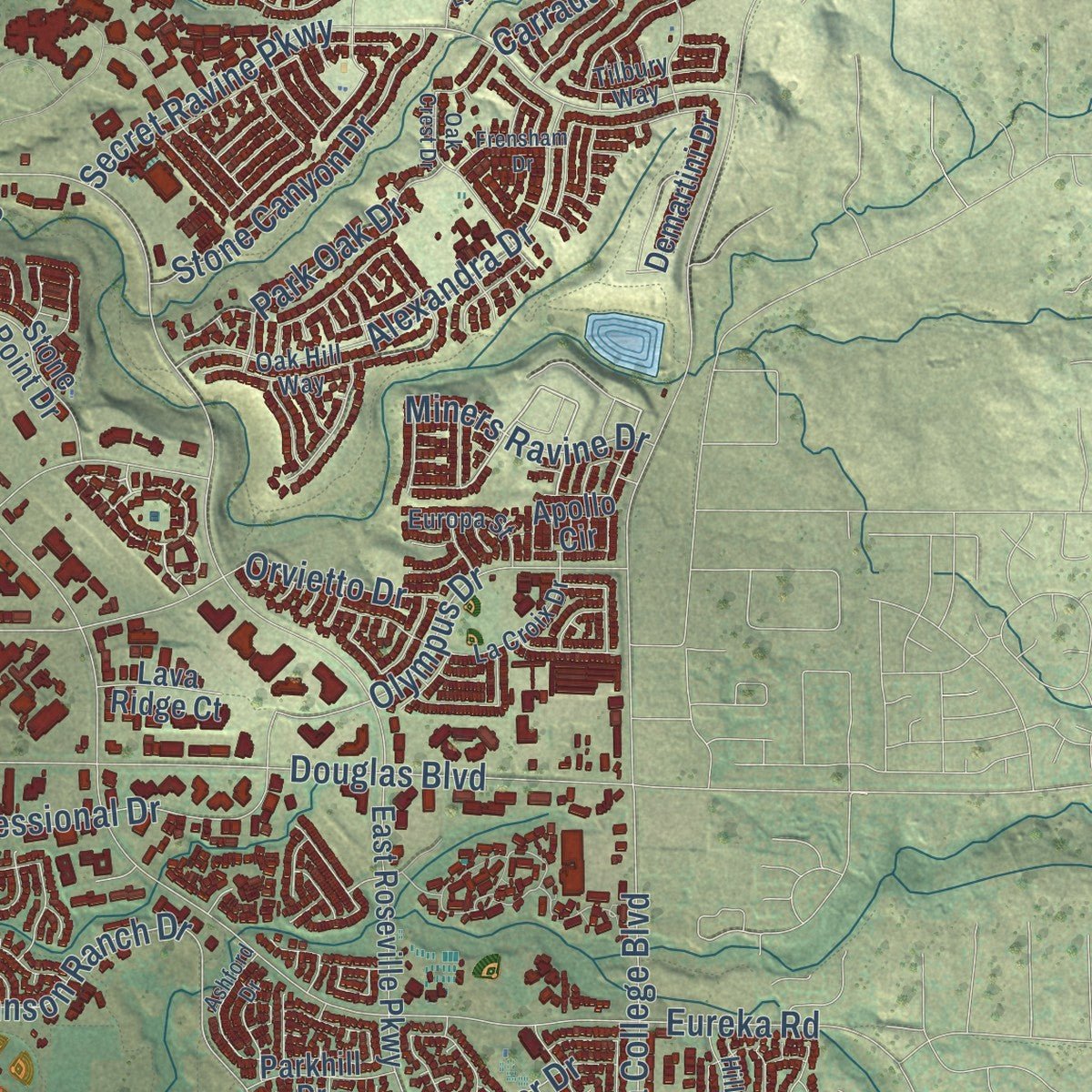
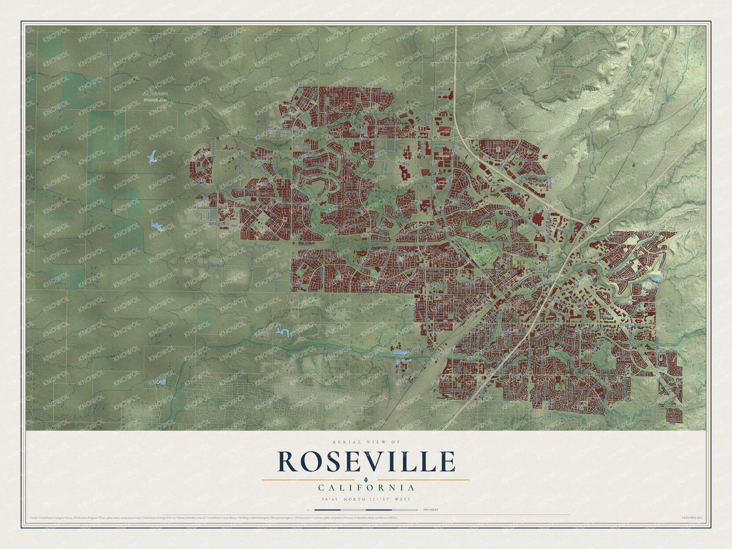
Explore Roseville, California from a whole new perspective. Created using aerial imagery and detailed geographic data, this map captures Roseville building by building, with labeled streets, familiar landmarks, and shaded topographical relief that highlights the natural contours of the landscape.
Combining modern data with the timeless character of a vintage atlas, this map is just as interesting up close as it is beautiful on the wall. Whether you grew up in Roseville, spent memorable years there, or call it home today, this unique map is a great way to celebrate a place that means something to you. Zoom in on the preview to look for your street, and then order a print to put your memories on the wall.
Three ways to hang it

Unframed archival matte, a black wood frame or a white wood frame.
Up close
Geography Worth Displaying
This map was created using accurate cartographic data and authoritative geographic sources, including the U.S. Geological Survey and the Census Bureau. The map brings together terrain, waterways, roads, and building detail. The majority of the streets are labeled, houses are accurately depicted, and the topography is derived from government sources. Combining local data with carefully composed color and shading leads to this beautifully detailed Roseville artwork for your wall.
Rather than simply showing street outlines, we’ve included as many of the street names as we could reasonably fit on the map while keeping their names legible. Zoom in on the high resolution preview to see exactly what’s on the map. We truly set out to create a statement piece for anyone who loves Roseville. So whether it’s for you, or a gift for someone you love, we hope this map of Roseville brings back fond memories.
Read the story behind this map of Roseville, California from 2026.

Find your street
Names on the Roseville map
Every name below is printed on this map. Look for your street, your school, the park where you played, or the pond down the road.
Places and landmarks2
- Roseville City Hall
- Al Johnson Wildlife Area
Streets and roads339
- Roseville Parkway
- Highway 65
- Pleasant Grove Boulevard
- Phillip Road
- Foothills Boulevard
- Base Line Road
- Fiddyment Road
- Woodcreek Oaks Boulevard
- Blue Oaks Boulevard
- Junction Boulevard
- Washington Boulevard
- Sierra College Boulevard
- Douglas Boulevard
- Eureka Road
- Westbrook Boulevard
- Old Highway 65
- Harding Boulevard
- North Harding Boulevard
- Cirby Way
- Vernon Street
- Industrial Avenue
- Rocky Ridge Drive
- Market Street
- Vista Grande Boulevard
- Diamond Oaks Road
- Atkinson Street
- Sunrise Avenue
- Del Webb Boulevard
- North Hayden Parkway
- Old Auburn Road
Show all 339 streets
- North Sunrise Avenue
- Vista Creek Drive
- Pettigrew Road
- Secret Ravine Parkway
- Highland Park Drive
- Timberrose Way
- Atlantic Street
- Lead Hill Boulevard
- Sunset Boulevard West
- Riverside Avenue
- Main Street
- Taylor Road
- Bob Doyle Drive
- Country Club Drive
- Shasta Street
- Johnson Ranch Drive
- Alexandra Drive
- Hayden Parkway
- North Cirby Way
- Upland Drive
- Trehowell Drive
- Oak Ridge Drive
- Westpark Drive
- Crocker Ranch Road
- Gibson Drive
- McAnally Drive
- Misty Wood Drive
- Elm Street
- Garland Way
- Hp Way
- Porter Drive
- Steinbeck Drive
- Hickory Street
- Professional Drive
- Olympus Drive
- McLaren Drive
- Reserve Drive
- Coloma Way
- Stone Canyon Drive
- Loretto Drive
- Corin Drive
- Darling Way
- Vineyard Road
- Crestmont Avenue
- Berry Street
- Nicole Gee Drive
- School House Lane
- Dawnridge Road
- Pleasant Street
- Grove Street
- Lawton Avenue
- South Bluff Drive
- Krpan Drive
- Atwell Street
- Orlando Avenue
- Miners Ravine Drive
- Horncastle Avenue
- Carradale Drive
- Scarborough Drive
- Big Bear Drive
- Melody Lane
- Angus Road
- Buckskin Lane
- Grider Drive
- Americana Drive
- Park Oak Drive
- Heritage Drive
- Sierra Boulevard
- Caragh Street
- Opal Drive
- Lost Lake Lane
- Solaire Drive
- Brady Lane
- Roseville Road
- McNally Drive
- Chilton Drive
- Oak Street
- Ridgecrest Way
- Lockridge Drive
- Keehner Avenue
- Crawford Parkway
- Beckett Drive
- Sixth Street
- Lafayette Drive
- Gerry Way
- Payson Avenue
- Orvietto Drive
- Booth Road
- Vine Avenue
- Big Bend Drive
- Danielle Drive
- Earl Avenue
- Wringer Drive
- King Road
- Pfe Road
- Galilee Road
- Rand Way
- Antrim Drive
- Trestle Road
- Fig Street
- Niblick Drive
- Marlin Drive
- East Street
- New Meadow Drive
- Grey Bunny Drive
- Monterey Pines Drive
- Amington Drive
- Billington Lane
- East Roseville Parkway
- North State Highway 65
- Parkside Way
- Freedom Way
- Galleria Ci
- Sierra Gardens Drive
- Church Street
- Diamond Woods Circle
- Circuit Drive
- Champion Oaks Drive
- Stanford Ranch Road
- South Cirby Way
- Automall Drive
- Winding Creek Road
- Sun City Boulevard
- Pleasant Grove Bl
- Avenue Martina
- Lincoln Street
- Antelope Creek Drive
- Hallissey Drive
- Kensington Drive
- Painted Desert Drive
- Hilltop Circle
- Folsom Road
- Manzanita Avenue
- Village Green Drive
- Fifteen Mile Drive
- Green Grove Lane
- Sawtell Road
- Stonebridge Way
- Hydra Circle
- Sebastian Way
- Dickinson Drive
- San Simeon Drive
- Santa Clara Drive
- Sevilla Drive
- Campus Parkway
- Blossom Hill Way
- Stone Point Drive
- Union Street
- Avondale Drive
- Old Coach Drive
- Whistlestop Way
- Demartini Drive
- Maple Creek Drive
- Fenton Way
- Apollo Circle
- Santa Inez Street
- Ashton Drive
- Stansfield Drive
- Symphony Avenue
- Fifth Street
- Castle Rock Way
- Cll Las Casas
- March Road
- Firefly Green Lane
- Mallard Lane
- Harvey Way
- McRae Way
- Parkview Drive
- Blue Lane
- Park Regency Drive
- Park Drive
- Quails Nest Street
- Lockton Drive
- Revere Drive
- Inglis Way
- Parkhill Drive
- Cargill Way
- Ainsdale Drive
- Zinnia Way
- Melrose Avenue
- Holt Parkway
- Thurton Drive
- Larkin Drive
- Russell Court
- Camino Real Way
- Roxby Way
- Juanita Way
- Thrive Drive
- Lyne Bay Drive
- Yale Drive
- Kenroy Lane
- Lava Ridge Court
- Loveland Way
- Quincy Avenue
- Eaton Circle
- Porch Swing Drive
- Veterans Drive
- Mother Lode Drive
- Luxor Lane
- Willow Avenue
- Lora Way
- Derrylin Drive
- Rustler Drive
- Alden Way
- High Street
- Malta Drive
- Smith Lane
- Westhills Drive
- Spring Grove Drive
- Rose Garden Lane
- Brick Mason Circle
- Sheridan Avenue
- McCloud Way
- Alta Vista Avenue
- Bickleigh Loop
- Tahoe Avenue
- Rose Creek Road
- Kirkhill Drive
- Oak Hill Way
- Portside Circle
- Radiant Way
- Laporte Drive
- Zola Avenue
- Hillsborough Drive
- Millport Drive
- La Croix Drive
- Acton Way
- Ludlow Drive
- Rosestone Lane
- Eskaton Loop
- Chelsea Way
- Hanisch Drive
- Sienna Loop
- Pilgrims Drive
- Evelyn Avenue
- Swallow Way
- Fairway Drive
- Adora Circle
- Central Park Drive
- Keith Way
- Europa Street
- Dudley Drive
- Lavande Drive
- Octave Avenue
- Somers Street
- Jaffrey Street
- Ellison Drive
- Starry Night Lane
- Richland Way
- Salmon Drive
- Kent Street
- Echo Rock Lane
- Arbor Drive
- Third Street
- Kodiak Way
- Tilbury Way
- Shady Fir Lane
- Chase Drive
- Dusk Lane
- Wills Road
- Flint Street
- Whyte Avenue
- Kingswood Drive
- Casterbridge Drive
- Canevari Drive
- Stagecoach Circle
- Oak Crest Drive
- Opportunity Drive
- Sunningdale Drive
- Crestfield Circle
- Thistle Down Drive
- Old Hart Ranch Road
- Vignolia Loop
- Talmont Circle
- Cushendall Drive
- Luciana Way
- Derek Place
- Thornhill Drive
- Morningstar Drive
- Pruett Drive
- Fox Hollow Way
- Greatfield Drive
- Cardinal Way
- Spring Valley Drive
- Creamery Way
- Ashford Drive
- Panther Place
- Jennifer Circle
- Silkwood Way
- Mount Rose Way
- Woodacre Way
- Mallard Creek Drive
- Autumn Leaves Drive
- Farridge Drive
- Frensham Drive
- West Duranta Street
- Goldfield Way
- Riesling Drive
- Bagby Alley
- Delta Breeze Court
- Machado Lane
- Cirby Hills Drive
- Colnar Street
- Highland Pointe Drive
- Lindsay Drive
- Hay Ride Lane
- Early Way
- Puebla Way
- Varick Drive
Names are listed as they appear on the printed map. Zoom into the product photos to find them.
About Roseville, California
Roseville is a city of 147,773 people in Placer County, the most populous city in the county. The Nisenan people lived on this land for more than 2,000 years before disease, miners and settlers drove them out. A settlement then grew up around Griders, a stagecoach stop, and in 1864 the Central Pacific laid its transcontinental tracks northeast out of Sacramento. Where those tracks crossed the California Central Railroad, the place was named Junction, and in time Junction became Roseville.
In 1906 the Southern Pacific shifted its railroad facilities from Rocklin to Roseville, and the town grew fast. It incorporated as a city in 1909, and businesses soon put up more than 100 buildings. By 1929 the railroad employed as many as 1,225 people in a city of 6,425, and during World War II the yards were busier than they had ever been.
- The world's largest ice plantIn 1913 the Pacific Fruit Express building opened in Roseville. At the time, no plant anywhere on earth made more ice. It was one of more than 100 structures that went up after the Southern Pacific arrived.
- Downtown moves eastIn 1950 a railroad underpass was built on Washington Boulevard, then called Seawell. It eased crossings, but traffic bypassed the business district north of the tracks, and its shops lost customers. After Interstate 80 was finished in 1956, new businesses and residents headed toward what became East Roseville, and the old downtown slowly declined. In 1988 the city began a multi-million dollar plan to rebuild about 207 acres at its core, and a new Civic Center opened in 2013.
- Explosion in the rail yardOn April 28, 1973, a load of munitions headed for the Vietnam War blew up in the Southern Pacific yard. The blast and the fire that followed became known as the Roseville Yard Disaster.
- Tech jobs and fast growthHewlett Packard came to Roseville in 1979 and NEC followed in 1983. The city held 28,988 people in 1985, grew to 44,685 just five years later and reached 74,234 by 2000, as homes and shopping centers spread beyond the historic downtown.
Keep exploring California
Roseville is one of 1,990 California towns we've mapped. Every dot on the map is a print of its own.
The search covers every state, California first.
Near Roseville
Order 2 or more town maps and save 10%. Shown in the size and finish you picked above, so they hang as a set.
- Antelope 12" x 18" / Archival Matte Print $39.99
- Whitney 12" x 18" / Archival Matte Print $39.99
- Rocklin 12" x 18" / Archival Matte Print $39.99


More maps nearby: Citrus Heights, Foothill Farms, Loomis, Lincoln and North Highlands.
The art of mapping a place
How This Map Was Made
Real places. Remarkable detail. Discover the layers that turn geographic data into a map of home.

The view from above
Aerial imagery reveals the character of the land: woodland, open fields, and the patterns of a place.

The shape of the land
Elevation data brings hills, valleys, and subtle changes in the landscape into view.

The details of home
Roads, waterways, and building footprints come together to make the map feel unmistakably local.

Geography becomes art
Considered color, shading, and typography bring the layers together in a map made for your wall.


Process illustrated with Mendon, Massachusetts. Aerial imagery: USDA NAIP. Terrain: USGS 3D Elevation Program. Map details and finished artwork: KNOWOL.
The Details
About This Print
Choose an archival matte print, or a black or white Ayous wood frame. The archival matte print is unframed.
Select your size and finish above to see the matching product image and price.
Materials & Craftsmanship
A contemporary map with the character of a classic atlas, printed on archival matte paper. Optional frames are made from Ayous wood.
Your printed map does not include the watermark shown in the full-map preview.
Shipping & Delivery
Free shipping within the United States. Every print is made to order in the USA.
Buying a gift? Add a note in your cart and we'll include it. We never put prices in the package.
Prints ship within 2 to 3 business days. Allow 7 to 10 days total from ordering for delivery. Timing may vary during holidays or periods of high order volume.
Read our shipping policy.
Returns and damaged prints
Each print is made to order. Change-of-mind refunds are not available after production.
If your print arrives damaged, misprinted or incorrect, contact support@knowol.com within 30 days of receiving it. Include your order number, photos and a description of the issue.
Read our full refund and replacement policy. For questions about your order, email support@knowol.com.