


Search for another town





Free U.S. delivery 7 to 10 days after you order
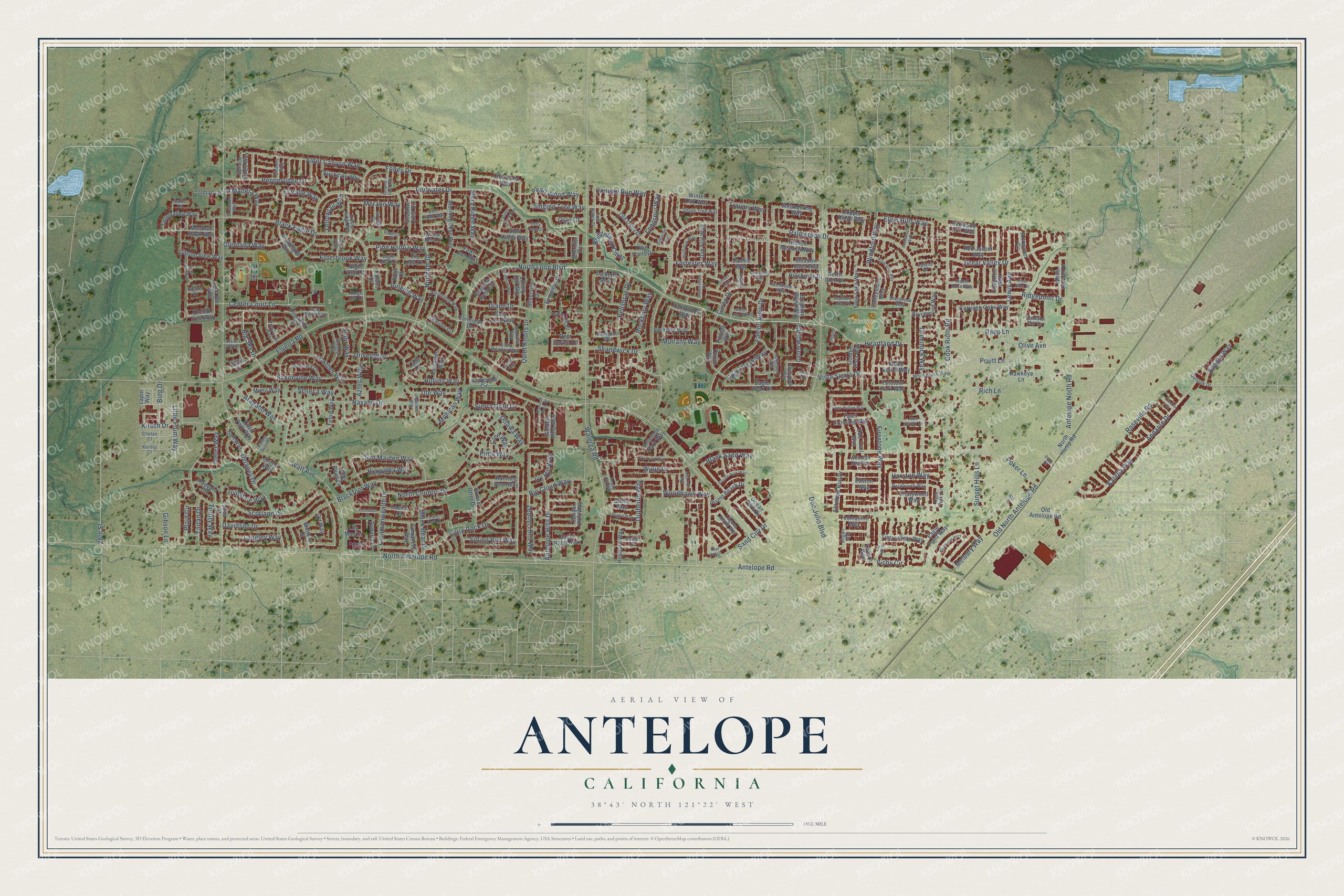
Antelope, California Map Art
Building by building, with labeled streets and shaded relief.
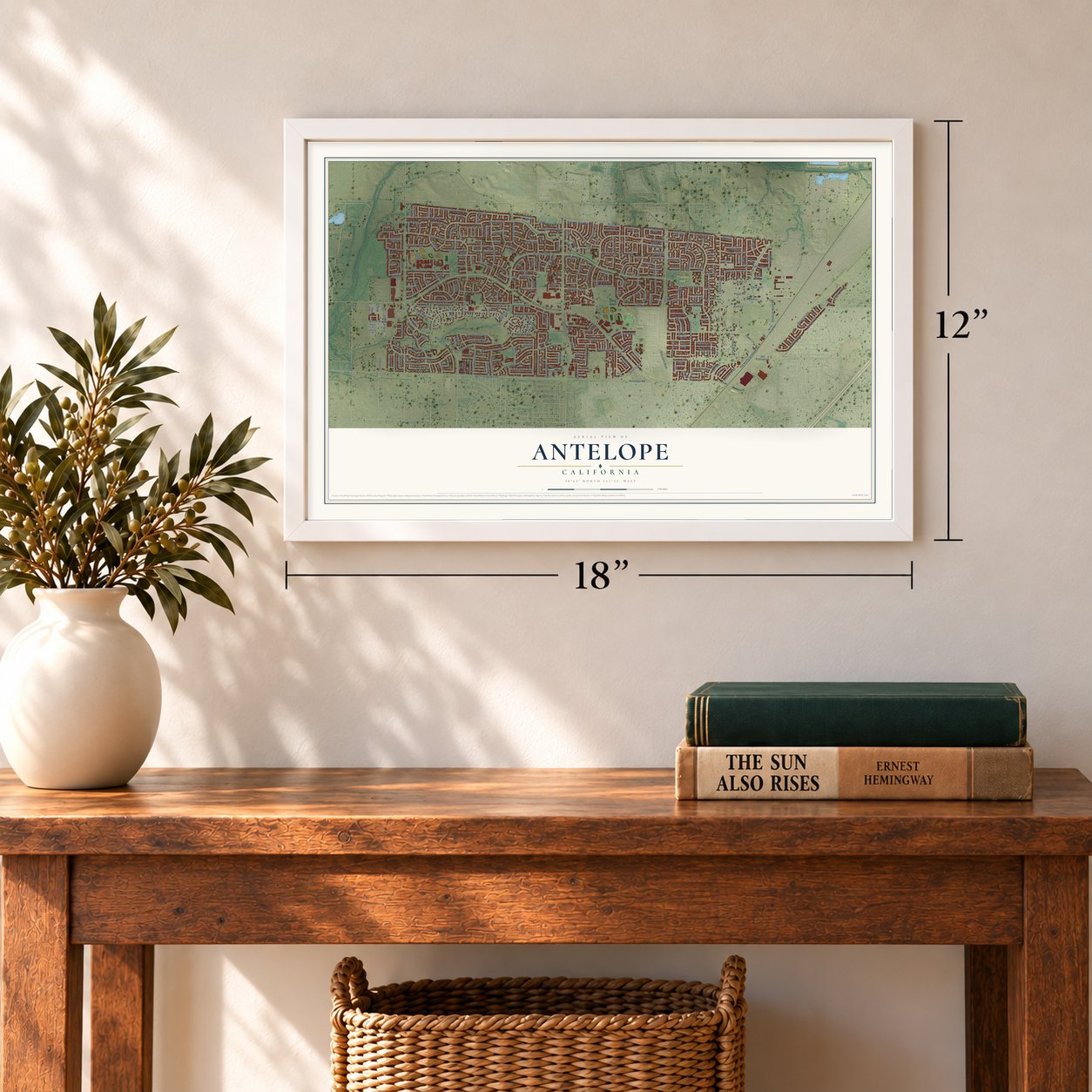
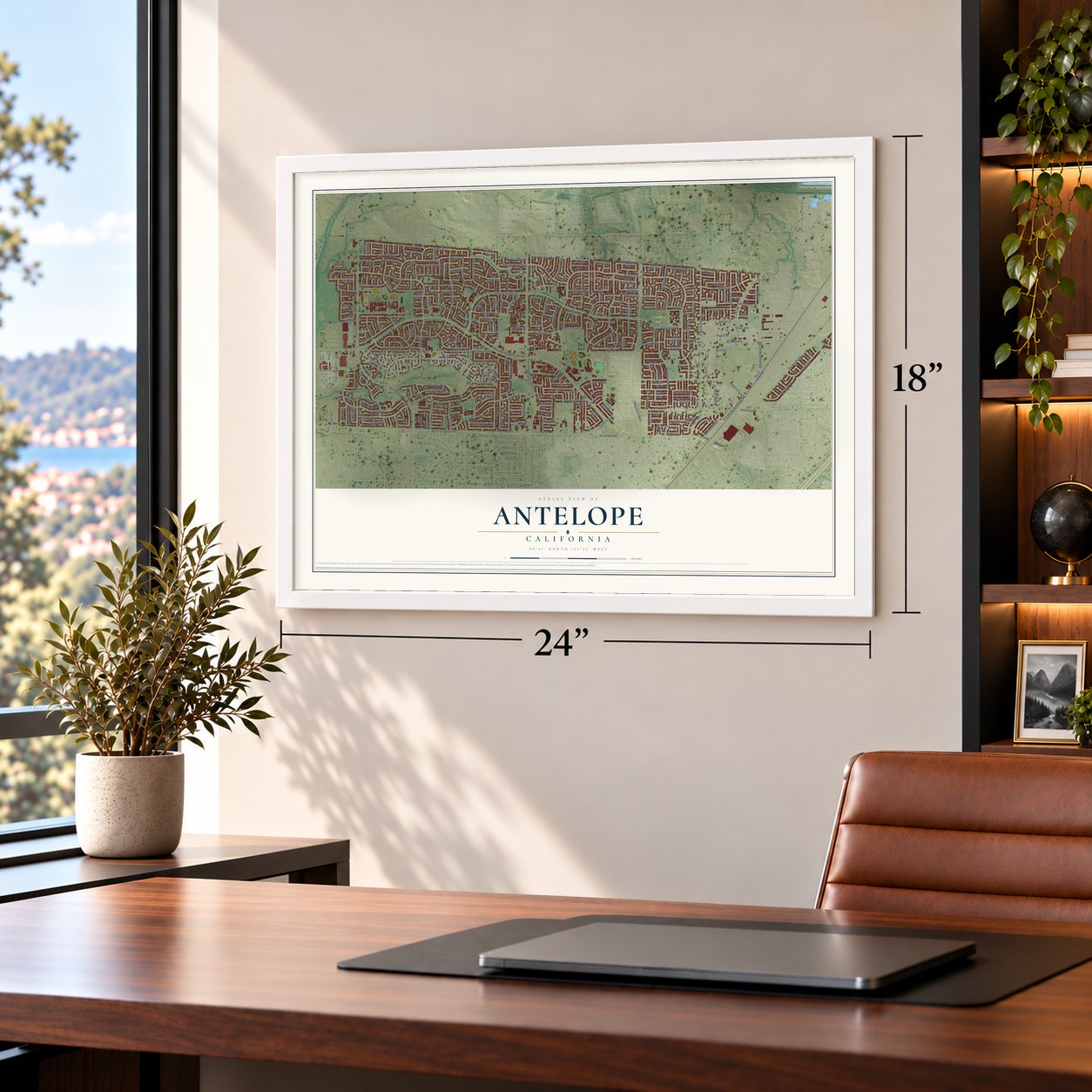
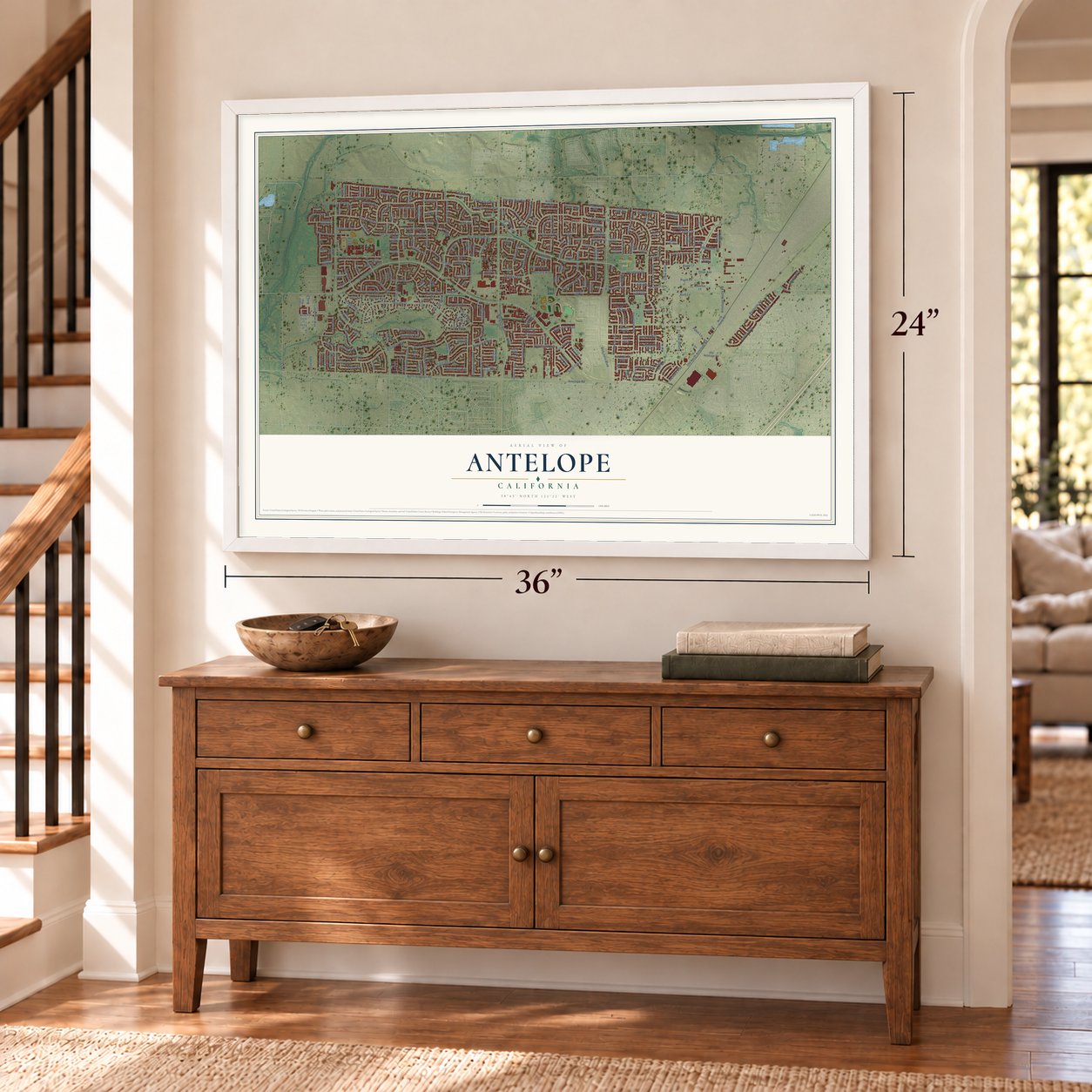
12" x 18" Archival Matte Print
A Map of Home. A Work of Art.
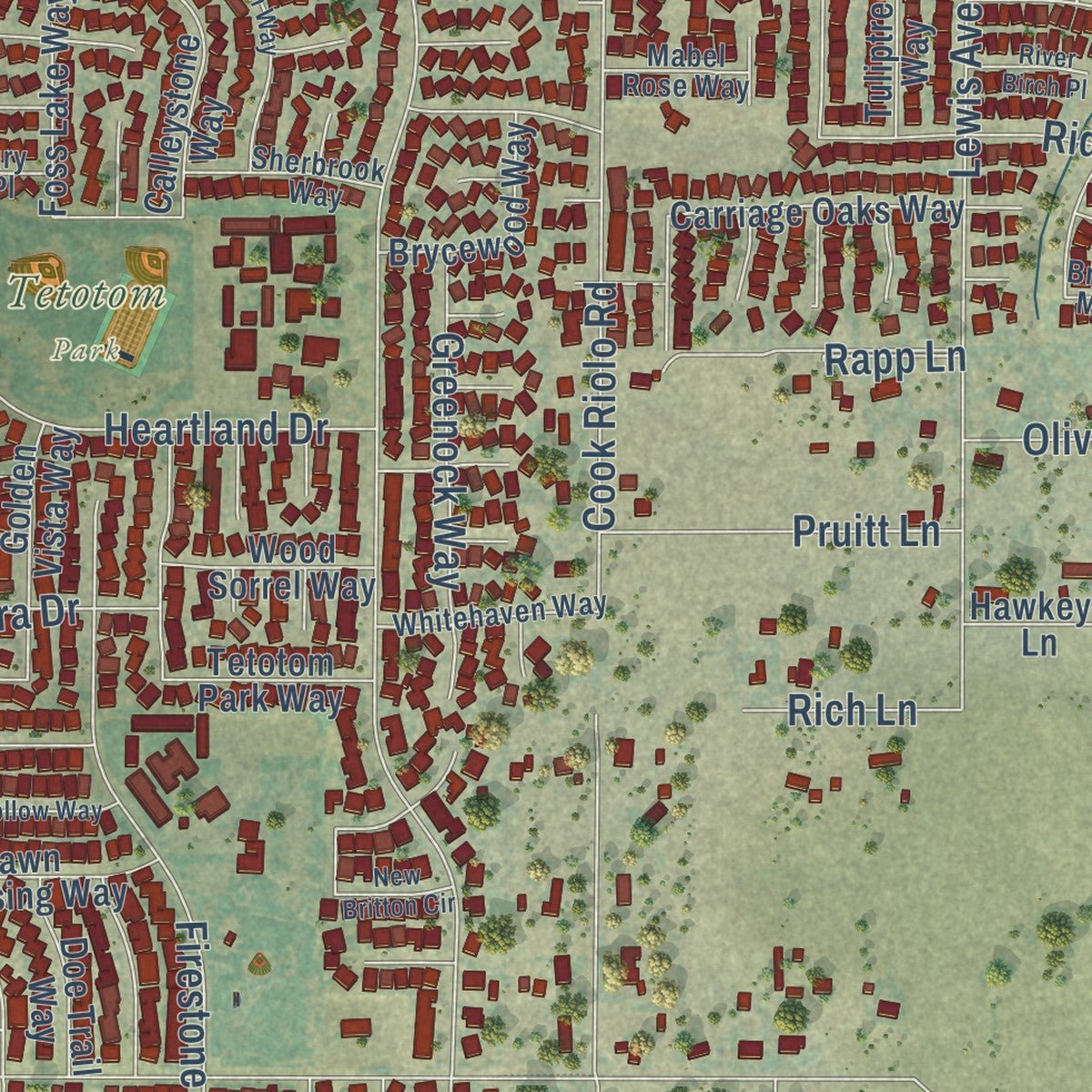
Explore Antelope, California from a whole new perspective. Created using aerial imagery and detailed geographic data, this map captures Antelope building by building, with labeled streets, familiar landmarks, and shaded topographical relief that highlights the natural contours of the landscape.
Combining modern data with the timeless character of a vintage atlas, this map is just as interesting up close as it is beautiful on the wall. Whether you grew up in Antelope, spent memorable years there, or call it home today, this unique map is a great way to celebrate a place that means something to you. Zoom in on the preview to look for your street, and then order a print to put your memories on the wall.
Three ways to hang it
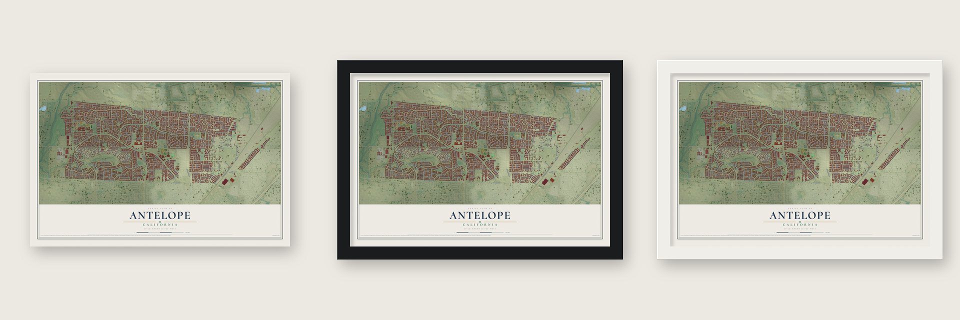
Unframed archival matte, a black wood frame or a white wood frame.
Up close
Geography Worth Displaying
This map was created using accurate cartographic data and authoritative geographic sources, including the U.S. Geological Survey and the Census Bureau. The map brings together terrain, waterways, roads, and building detail. The majority of the streets are labeled, houses are accurately depicted, and the topography is derived from government sources. Combining local data with carefully composed color and shading leads to this beautifully detailed Antelope artwork for your wall.
Rather than simply showing street outlines, we’ve included as many of the street names as we could reasonably fit on the map while keeping their names legible. Zoom in on the high resolution preview to see exactly what’s on the map. We truly set out to create a statement piece for anyone who loves Antelope. So whether it’s for you, or a gift for someone you love, we hope this map of Antelope brings back fond memories.
Read the story behind this map of Antelope, California from 2026.

Find your street
Names on the Antelope map
Every name below is printed on this map. Look for your street, your school, the park where you played, or the pond down the road.
Places and landmarks2
- Sabre City
- Tetotom Park
Streets and roads292
- North Loop Boulevard
- Heartland Drive
- Sun Maiden Way
- Harston Way
- Big Sky Drive
- Saxonville Way
- Sand City Drive
- Elverta Road
- Palmerson Drive
- Antelope Road
- Watt Avenue
- North Antelope Road
- Antelope North Road
- Walerga Road
- Don Julio Boulevard
- Scotland Drive
- North Country Drive
- Roseville Road
- Redwater Drive
- Poker Lane
- Cook Riolo Road
- Navaho Drive
- Black Eagle Drive
- Blackfoot Way
- Falcon View Drive
- 28th Street
- Northam Drive
- Winje Drive
- Firestone Way
- Fobes Drive
Show all 292 streets
- Aztec Way
- Lewis Avenue
- Center Court Lane
- Big Cloud Way
- Great Valley Drive
- Davidson Drive
- Story Ridge Way
- Rollins Way
- Pima Way
- Sierra Gold Drive
- Ridgepoint Drive
- Woodhawk Way
- Olive Avenue
- Little Rock Drive
- Elgin Hills Way
- Pepperridge Drive
- Country Run Way
- Andante Drive
- Lowther Way
- Seneca Way
- Bridgefield Cmns
- Shandwick Drive
- Longspur Way
- Prior Way
- Ivy Hill Way
- Delaney Drive
- Rockbury Way
- Alder Canyon Way
- Black Sand Way
- Driver Way
- Katella Way
- Pine Hollow Way
- Antelope Hills Drive
- Melbury Way
- Eagle Peak Way
- Mulrany Way
- Old North Antelope Road
- Diane Drive
- Pinehill Way
- Bellsbrae Drive
- Zephyr Hills Way
- Orpheum Way
- Travary Way
- Commonwealth Drive
- Arapaho Way
- Pearl Wood Way
- El Valle Way
- Quiet Knolls Drive
- Bing Drive
- Esterbrook Way
- Vichy Circle
- Caber Way
- Black Bear Drive
- Hiawatha Way
- Mohican Way
- Greenock Way
- Glentana Way
- Pruitt Lane
- Langley Way
- La Madera Way
- Vista Sierra Drive
- Sunset Hills Lane
- Windford Way
- Singing Tree Way
- Sitting Bull Way
- Adagio Way
- Little Plum Way
- Plaid Circle
- Merano Way
- Irvindale Way
- Tartan Drive
- Yellowtail Way
- Careo Drive
- Ute Way
- Cree Way
- Forrester Way
- Thrifty Way
- Kirsch Drive
- Gibson Lane
- Ottawa Way
- Rich Lane
- Oslo Court
- Rapp Lane
- Benjamin Drive
- Castle Wynd Drive
- Brighton Wynd Way
- Groveland Way
- Winter Oak Way
- Golden Ring Way
- Old Dairy Drive
- Pinefield Drive
- Dalkeith Way
- Fawn Crossing Way
- Meandering Way
- Zachis Way
- Hidden Meadow Way
- Twin Trails Drive
- Cougar Hills Way
- Calleystone Way
- Teton Way
- Deer Spring Circle
- Tourmaline Way
- Tetotom Park Way
- Thomasino Way
- Ocean Park Drive
- Old Antelope Road
- Orchid Tree Way
- Carriage Oaks Way
- Antelope Run Drive
- Clarion Circle
- Arrowroot Circle
- Copper Ridge Way
- Morning Skye Way
- Gibson View Way
- Bramble Bush Circle
- Shadow Crest Circle
- Meadow Pass Way
- Vista Point Lane
- Acappella Circle
- Simi Valley Way
- Comanche Way
- Rambleton Way
- North Hump Road
- Swindon Way
- Chamonix Way
- Lily Mar Lane
- Roberta Lane
- Meadow Hawk Way
- Brown Otter Drive
- White Spruce Drive
- Redwood Burl Way
- Grey Livery Way
- Red Jasper Way
- Hillsbrook Drive
- Filifera Way
- Running Bear Way
- Tierra Vista Way
- Lonely Hill Way
- Brycewood Way
- 32nd Street
- Silk Tree Way
- Eagle Point Way
- Pismo Beach Drive
- Otium Way
- Birchdale Way
- Foss Lake Way
- Oak Flat Way
- Ort Way
- Spruce Ridge Way
- Rudyard Circle
- Garbo Way
- Chatswood Way
- Mono Way
- Tarmigan Drive
- Hepburn Way
- Wood Sorrel Way
- Antelope Park Way
- Fairlands Way
- Doe Trail Way
- Quail Park Way
- Eagle Ridge Way
- Perth Glen Drive
- Oriole Way
- Tuliptree Way
- Golden Vista Way
- Gull Way
- Midtown Drive
- Fawn Run Way
- Tolman Lane
- Eagle Peak Court
- Silverside Drive
- Luzern Way
- Hawkeye Lane
- Easton Way
- Lasick Court
- Lily Hill Court
- Ruge Court
- Kolbus Court
- Night Star Court
- Ladd Court
- Wolfe Court
- Lapin Way
- Clydebank Way
- Hyde Park Circle
- Albertville Way
- Apartment Road
- Weybridge Way
- Hartlepool Way
- Brewster Mill Circle
- Laguna Beach Way
- Tawny Meadow Way
- Giverny Circle
- Ackerson Way
- Whitehaven Way
- Brownlea Circle
- Gray Mare Way
- Eagle Crest Circle
- Sheehan Way
- Shade Tree Way
- Beckworth Way
- Sherbrook Way
- Preakness Way
- Fan Wood Way
- Gloriann Way
- Crystal Ridge Way
- Lonestar Way
- Pawnee Way
- Deer Walk Way
- Rapozo Court
- El Viento Way
- Sadie Court
- Mabel Rose Way
- Outlook Drive
- Dishers Way
- Whitetail Run Way
- Rosbury Dell Place
- Bogan Way
- Bacall Court
- Cool Water Court
- Valley Quail Court
- Chelan Court
- Apland Place
- Willow Bend Place
- Ridge Rim Court
- Kordia Court
- Nolana Court
- Pine Street
- Oakenshield Circle
- Piper Glen Way
- Porto Pino Way
- Diamond Rock Drive
- New Britton Circle
- Megan Ann Way
- Scrub Oak Way
- Borthwick Way
- Misty Oak Way
- Fawn Hollow Way
- La Tour Drive
- Pacific Park Way
- Sutter Creek Way
- Scotswood Way
- Courtyard Way
- Wind Flower Way
- Sycamore Glen Way
- Bogart Way
- Cantata Way
- Black Saddle Drive
- Mist Trail Way
- Treleaven Court
- Caballero Lane
- Silver Run Way
- Perry Creek Court
- Light Foot Court
- Dowitcher Way
- River Birch Place
- Cereus Way
- Teal Bay Court
- Elegans Court
- Piccolo Court
- Hearth Place
- Beryl Place
- Ash Street
Names are listed as they appear on the printed map. Zoom into the product photos to find them.
About Antelope, California
From the Sacramento County History: "The Twelve-Mile House was built in 1853 by a man named Caldwell, and was known as the Antelope ranch."
Keep exploring California
Antelope is one of 1,990 California towns we've mapped. Every dot on the map is a print of its own.
The search covers every state, California first.
Near Antelope
Order 2 or more town maps and save 10%. Shown in the size and finish you picked above, so they hang as a set.
- Foothill Farms 12" x 18" / Archival Matte Print $39.99
- North Highlands 12" x 18" / Archival Matte Print $39.99
- Citrus Heights 12" x 18" / Archival Matte Print $39.99


More maps nearby: McClellan Park, Roseville, Elverta, Rio Linda and Carmichael.
The art of mapping a place
How This Map Was Made
Real places. Remarkable detail. Discover the layers that turn geographic data into a map of home.

The view from above
Aerial imagery reveals the character of the land: woodland, open fields, and the patterns of a place.

The shape of the land
Elevation data brings hills, valleys, and subtle changes in the landscape into view.

The details of home
Roads, waterways, and building footprints come together to make the map feel unmistakably local.

Geography becomes art
Considered color, shading, and typography bring the layers together in a map made for your wall.


Process illustrated with Mendon, Massachusetts. Aerial imagery: USDA NAIP. Terrain: USGS 3D Elevation Program. Map details and finished artwork: KNOWOL.
The Details
About This Print
Choose an archival matte print, or a black or white Ayous wood frame. The archival matte print is unframed.
Select your size and finish above to see the matching product image and price.
Materials & Craftsmanship
A contemporary map with the character of a classic atlas, printed on archival matte paper. Optional frames are made from Ayous wood.
Your printed map does not include the watermark shown in the full-map preview.
Shipping & Delivery
Free shipping within the United States. Every print is made to order in the USA.
Buying a gift? Add a note in your cart and we'll include it. We never put prices in the package.
Prints ship within 2 to 3 business days. Allow 7 to 10 days total from ordering for delivery. Timing may vary during holidays or periods of high order volume.
Read our shipping policy.
Returns and damaged prints
Each print is made to order. Change-of-mind refunds are not available after production.
If your print arrives damaged, misprinted or incorrect, contact support@knowol.com within 30 days of receiving it. Include your order number, photos and a description of the issue.
Read our full refund and replacement policy. For questions about your order, email support@knowol.com.