


Search for another town



Free U.S. delivery 7 to 10 days after you order
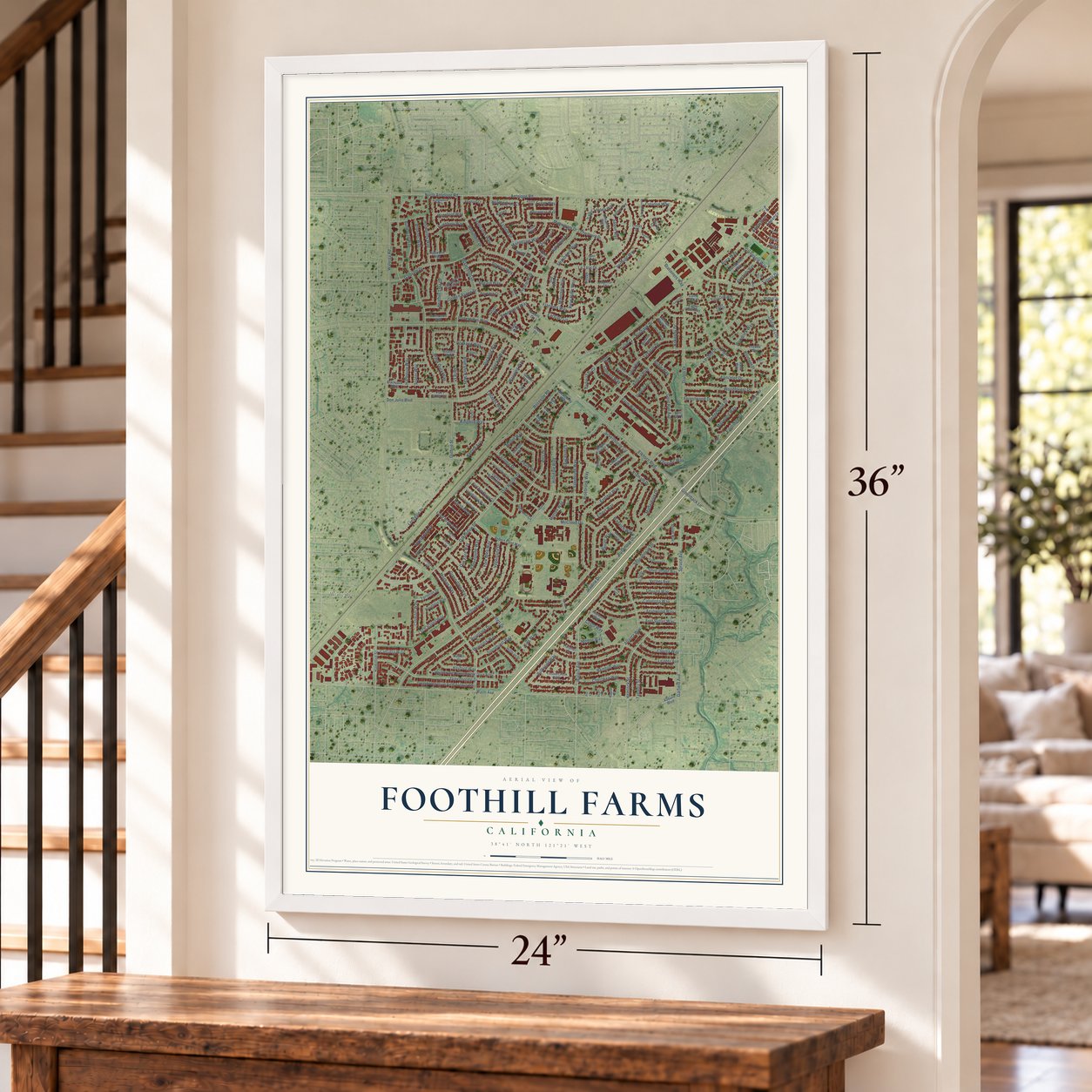
Foothill Farms, California Map Art
Building by building, with labeled streets and shaded relief.
12" x 18" Archival Matte Print
A Map of Home. A Work of Art.
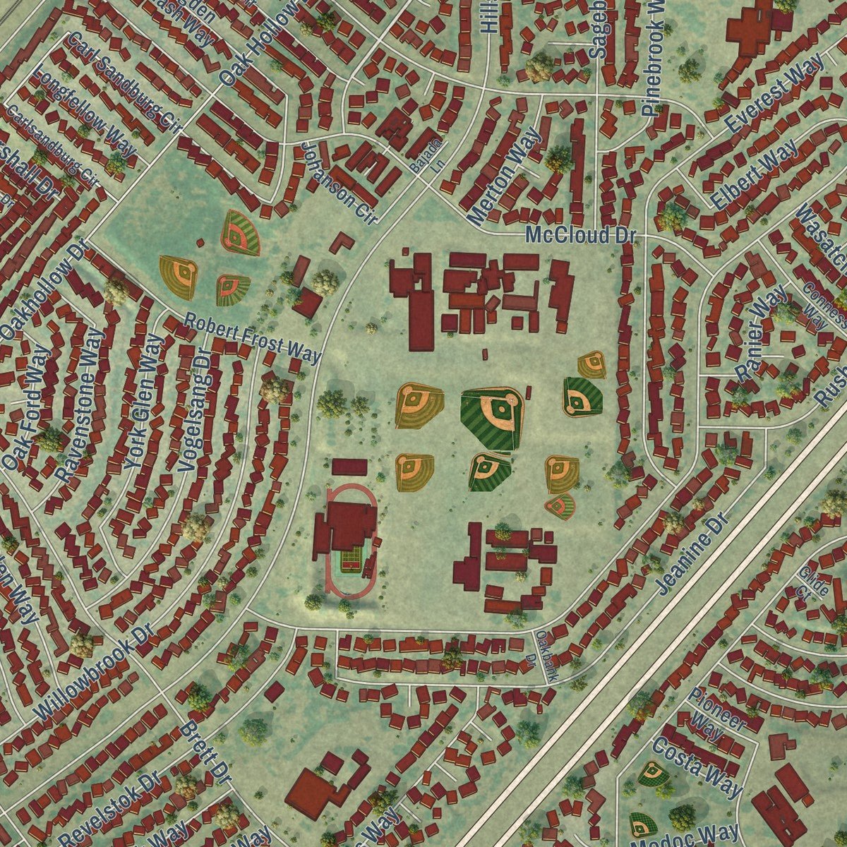
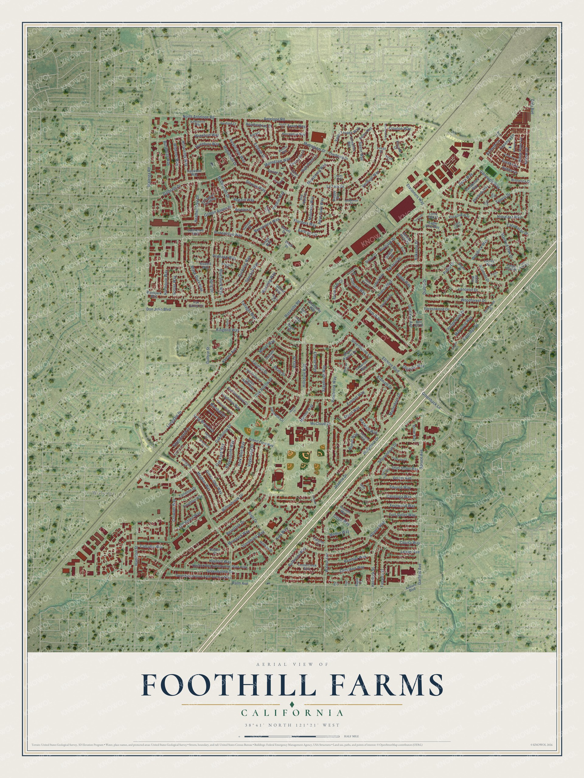
Explore Foothill Farms, California from a whole new perspective. Created using aerial imagery and detailed geographic data, this map captures Foothill Farms building by building, with labeled streets, familiar landmarks, and shaded topographical relief that highlights the natural contours of the landscape.
Combining modern data with the timeless character of a vintage atlas, this map is just as interesting up close as it is beautiful on the wall. Whether you grew up in Foothill Farms, spent memorable years there, or call it home today, this unique map is a great way to celebrate a place that means something to you. Zoom in on the preview to look for your street, and then order a print to put your memories on the wall.
Three ways to hang it
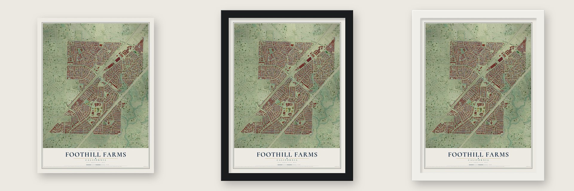
Unframed archival matte, a black wood frame or a white wood frame.
Up close
Geography Worth Displaying
This map was created using accurate cartographic data and authoritative geographic sources, including the U.S. Geological Survey and the Census Bureau. The map brings together terrain, waterways, roads, and building detail. The majority of the streets are labeled, houses are accurately depicted, and the topography is derived from government sources. Combining local data with carefully composed color and shading leads to this beautifully detailed Foothill Farms artwork for your wall.
Rather than simply showing street outlines, we’ve included as many of the street names as we could reasonably fit on the map while keeping their names legible. Zoom in on the high resolution preview to see exactly what’s on the map. We truly set out to create a statement piece for anyone who loves Foothill Farms. So whether it’s for you, or a gift for someone you love, we hope this map of Foothill Farms brings back fond memories.
Read the story behind this map of Foothill Farms, California from 2026.

Find your street
Names on the Foothill Farms map
Every name below is printed on this map. Look for your street, your school, the park where you played, or the pond down the road.
Places and landmarks1
- Walerga
Streets and roads257
- La Tour Drive
- Verdugo Way
- Villa Drive
- Stanford Oak Drive
- Bootjack Drive
- Croxton Way
- Roseville Road
- Antelope Road
- Diablo Drive
- Walerga Road
- Hillsdale Boulevard
- Palm Avenue
- Elkhorn Boulevard
- Don Julio Boulevard
- Andrea Boulevard
- Butterball Way
- Garfield Avenue
- Oakhollow Drive
- Shenandoah Drive
- Galbrath Drive
- Silverthorne Circle
- Greenholme Drive
- Oak Hollow Drive
- North Antelope Road
- Monument Drive
- Tacomic Drive
- Holworthy Way
- Brett Drive
- Revelstok Drive
- Everest Way
Show all 257 streets
- Verner Avenue
- Karm Way
- Jeanine Drive
- Gold Run Avenue
- Longdale Drive
- Eastridge Drive
- Sprig Drive
- McCloud Drive
- Tupelo Drive
- Buffwood Way
- Daly Avenue
- Rushmore Drive
- Kingbird Way
- Willowbrook Drive
- Roca Way
- Leader Avenue
- Hemlock Street
- Meghan Way
- Monogram Drive
- Monogram Way
- Flanders Way
- Rambler Way
- Sagebrush Way
- Fernwood Way
- Woodforest Drive
- Black Duck Way
- Lancelot Drive
- Calistoga Way
- Stagecoach Drive
- Auspicious Way
- Atlanta Way
- Hayford Way
- McDermott Drive
- Speckle Way
- Walnut Avenue
- Matterhorn Drive
- Regard Way
- Vogelsang Drive
- Keema Avenue
- Pablo Drive
- Kies Way
- Hamilton Street
- Heather Tree Drive
- Azimuth Lane
- Himalaya Way
- Blue Duck Way
- Guthrie Street
- Hedgewood Drive
- Redhead Way
- Waxwing Way
- Spruce Avenue
- Pretentious Way
- York Glen Way
- Saint Tropez Way
- Esteem Drive
- Green Glen Way
- Widener Way
- Dunnbury Way
- Duckling Way
- Peale Drive
- Ravenstone Way
- Earlcort Circle
- Woodrick Way
- Cherokee Way
- Tiburon Way
- Topanga Lane
- Pinebrook Way
- Harlequin Way
- Storrow Way
- Loch Haven Way
- Predial Way
- Elbert Way
- Dover Lane
- Marshall Drive
- Heatherbrae Court
- Greenback Lane
- Strasbourg Way
- Gleneagle Way
- Hobbs Lane
- Sylmar Lane
- Tahama Street
- Eureka Lane
- Benevolent Way
- Ygnacio Drive
- Forestwood Drive
- Fort Sutter Way
- Stonehurst Way
- High Point Lane
- Monet Way
- Minoress Way
- Colusa Way
- Golden Aspen Drive
- Filaree Way
- Maywood Way
- Moorpark Way
- White River Lane
- Concert Way
- Saxon Way
- Crowder Way
- Kilkenny Drive
- Scoter Way
- Oak Ford Way
- Calcutta Way
- Roble Way
- Catamaran Drive
- Tarleton Drive
- Ranier Way
- Stationers Way
- Olympic Way
- Reyn Oaks Way
- Wrenford Way
- Merton Way
- Event Way
- Tanager Way
- Wasatch Way
- Long Branch Drive
- Klamath Drive
- Modoc Way
- Costa Way
- Ogden Nash Way
- Carl Sandburg Circle
- Woodside Drive
- Hayford Way Greenholme Drive Alley
- Greenholme Drive Palm Avenue Alley
- Tippwood Way
- Weatherby Way
- Cherbourg Drive
- Dieppe Way
- Donerail Drive
- Perceptive Way
- Robert Frost Way
- Silver Strand Way
- Timbercreek Way
- Demuth Circle
- Pioneer Way
- Barbara Lee Circle
- Creighton Way
- Satinwood Way
- Johanson Circle
- Blackjack Way
- Eagle View Way
- Candlestick Way
- Lorella Way
- Aberfeldy Way
- Mount Rainier Drive
- Gannet Way
- Versailles Way
- Buskirk Drive
- Fox Valley Circle
- Image Way
- Longfellow Way
- Reims Way
- Cimarron Way
- Shiloh Way
- Lexington Crossing
- Longs Peak Place
- Cherryville Lane
- Hillbrae Drive
- Vista Oak Way
- Winnetica Court
- Salmon River Drive
- Savant Drive
- Bluebill Way
- Boylston Court
- Old Nave Court
- Dream Court
- Loheit Way
- Luxford Court
- Refined Court
- Auburn Boulevard
- Fletcher Court
- Ruskin Court
- Phlox Court
- Aleta Way
- Loma Oak Court
- Pixcroft Court
- Bell Hill Drive
- Kinsey Court
- Smud Drive
- Ruger Court
- Lovas Drive
- Rapid Court
- Jack London Circle
- Carlsandburg Circle
- Kimblewick Way
- Conness Way
- Bestow Way
- Springwood Drive
- Harlen Court
- Ladefonos Court
- Nott Lane
- Ringneck Court
- Ojai Court
- Linda Oak Court
- Adieu Court
- Ithica Court
- Siskin Court
- Saint Lo Court
- Glide Court
- Sako Court
- Idria Court
- Pry Court
- Valparaiso Circle
- Bonanza Drive
- Gold Dust Drive
- Springhaven Circle
- Stonyford Lane
- Centennial Way
- Saint Bede Way
- Southern Pine Lane
- Bear River Drive
- Newport Lane
- Modesto Drive
- Yorktown Place
- Willowmont Circle
- Golden Dawn Way
- Sweet Birch Court
- Sawtooth Court
- Platina Court
- Osprey Court
- Pikes Peak Way
- Oakbank Drive
- Waverly Court
- Accord Court
- Melsee Court
- Bajada Lane
- Page Court
Names are listed as they appear on the printed map. Zoom into the product photos to find them.
Keep exploring California
Foothill Farms is one of 1,990 California towns we've mapped. Every dot on the map is a print of its own.
The search covers every state, California first.
Near Foothill Farms
Order 2 or more town maps and save 10%. Shown in the size and finish you picked above, so they hang as a set.
- North Highlands 12" x 18" / Archival Matte Print $39.99
- Antelope 12" x 18" / Archival Matte Print $39.99
- Citrus Heights 12" x 18" / Archival Matte Print $39.99


More maps nearby: McClellan Park, Carmichael, Rio Linda, Elverta and Fair Oaks.
The art of mapping a place
How This Map Was Made
Real places. Remarkable detail. Discover the layers that turn geographic data into a map of home.

The view from above
Aerial imagery reveals the character of the land: woodland, open fields, and the patterns of a place.

The shape of the land
Elevation data brings hills, valleys, and subtle changes in the landscape into view.

The details of home
Roads, waterways, and building footprints come together to make the map feel unmistakably local.

Geography becomes art
Considered color, shading, and typography bring the layers together in a map made for your wall.


Process illustrated with Mendon, Massachusetts. Aerial imagery: USDA NAIP. Terrain: USGS 3D Elevation Program. Map details and finished artwork: KNOWOL.
The Details
About This Print
Choose an archival matte print, or a black or white Ayous wood frame. The archival matte print is unframed.
Select your size and finish above to see the matching product image and price.
Materials & Craftsmanship
A contemporary map with the character of a classic atlas, printed on archival matte paper. Optional frames are made from Ayous wood.
Your printed map does not include the watermark shown in the full-map preview.
Shipping & Delivery
Free shipping within the United States. Every print is made to order in the USA.
Buying a gift? Add a note in your cart and we'll include it. We never put prices in the package.
Prints ship within 2 to 3 business days. Allow 7 to 10 days total from ordering for delivery. Timing may vary during holidays or periods of high order volume.
Read our shipping policy.
Returns and damaged prints
Each print is made to order. Change-of-mind refunds are not available after production.
If your print arrives damaged, misprinted or incorrect, contact support@knowol.com within 30 days of receiving it. Include your order number, photos and a description of the issue.
Read our full refund and replacement policy. For questions about your order, email support@knowol.com.