


Search for another town


Free U.S. delivery 7 to 10 days after you order
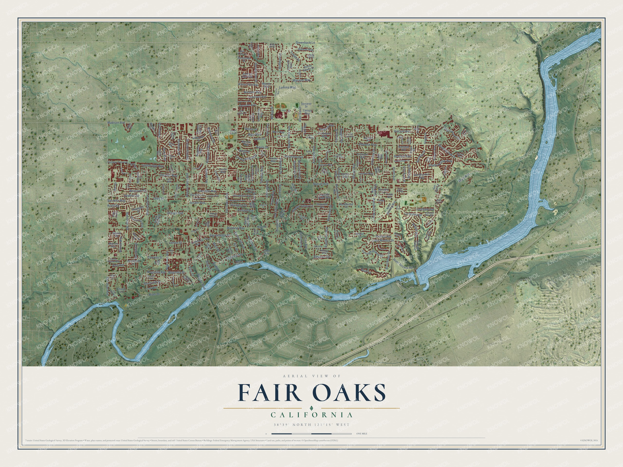
Fair Oaks, California Map Art
Building by building, with labeled streets and shaded relief.
12" x 18" Archival Matte Print
A Map of Home. A Work of Art.
Explore Fair Oaks, California from a whole new perspective. Created using aerial imagery and detailed geographic data, this map captures Fair Oaks building by building, with labeled streets, familiar landmarks, and shaded topographical relief that highlights the natural contours of the landscape.
Combining modern data with the timeless character of a vintage atlas, this map is just as interesting up close as it is beautiful on the wall. Whether you grew up in Fair Oaks, spent memorable years there, or call it home today, this unique map is a great way to celebrate a place that means something to you. Zoom in on the preview to look for your street, and then order a print to put your memories on the wall.
Three ways to hang it

Unframed archival matte, a black wood frame or a white wood frame.
Up close
Geography Worth Displaying
This map was created using accurate cartographic data and authoritative geographic sources, including the U.S. Geological Survey and the Census Bureau. The map brings together terrain, waterways, roads, and building detail. The majority of the streets are labeled, houses are accurately depicted, and the topography is derived from government sources. Combining local data with carefully composed color and shading leads to this beautifully detailed Fair Oaks artwork for your wall.
Rather than simply showing street outlines, we’ve included as many of the street names as we could reasonably fit on the map while keeping their names legible. Zoom in on the high resolution preview to see exactly what’s on the map. We truly set out to create a statement piece for anyone who loves Fair Oaks. So whether it’s for you, or a gift for someone you love, we hope this map of Fair Oaks brings back fond memories.
Read the story behind this map of Fair Oaks, California from 2026.

Find your street
Names on the Fair Oaks map
Every name below is printed on this map. Look for your street, your school, the park where you played, or the pond down the road.
Places and landmarks2
- American River Parkway
- Phoenix Park
Streets and roads267
- Minnesota Avenue
- Greenback Lane
- Magnolia Avenue
- Magnolia Street
- Leatham Avenue
- Sacramento Street
- Sunset Avenue
- Madison Avenue
- Fair Oaks Boulevard
- Winding Way
- Kenneth Avenue
- San Juan Avenue
- Sunrise Boulevard
- Hazel Avenue
- Illinois Avenue
- Pennsylvania Avenue
- Phoenix Avenue
- New York Avenue
- Chicago Avenue
- River Drive
- Bannister Road
- Hoffman Lane
- Winding Oak Drive
- Orange Avenue
- Rimwood Drive
- La Serena Drive
- Buena Vista Avenue
- Kaula Drive
- Lumina Way
- Niessen Way
Show all 267 streets
- Greenridge Way
- Primrose Drive
- Sunset Terrace
- Long Canyon Drive
- Martsmith Way
- Archer Avenue
- Plumeria Avenue
- Hidden Valley Circle
- Arbardee Drive
- Runway Drive
- Riva Ridge Drive
- Palmyra Drive
- Lemon Street
- Olive Street
- Curragh Downs Drive
- Treecrest Avenue
- Cocoa Palm Way
- Main Street
- Bluff Lane
- Capitola Avenue
- Lake Nimbus Drive
- Deseret Avenue
- Westover Court
- Main Avenue
- Bridge Street
- Heather Road
- Kreth Road
- Southcliff Drive
- Trajan Drive
- Kewanee Street
- Maui Way
- Ridge Street
- Oahu Drive
- Manana Way
- Ascolano Avenue
- Ridgegate Way
- Natoma Avenue
- Arboleda Drive
- Earnscliff Avenue
- Dory Way
- Oak Glen Way
- Brookhill Drive
- Sunrise Hills Drive
- Shady Hollow Way
- Shamrock Drive
- Manzanillo Street
- Shangrila Drive
- McKay Street
- Cox Avenue
- Hill Street
- San Nita Way
- Paula Way
- Randhurst Way
- Skyway Drive
- River Access Road
- Forrestal Street
- Spring Glen Drive
- Glen Bar Way
- Timothy Way
- Filbert Avenue
- Vincent Avenue
- Amy Avenue
- Valonia Street
- Emperor Drive
- Olympic Way
- Kermes Avenue
- Arroyo Street
- Walali Way
- Lei Street
- Bedford Avenue
- Niblick Way
- Alair Vie Drive
- Nugget Road
- Villa Court
- Campoy Street
- Pollard Avenue
- Siesta Lane
- Vought Drive
- Sorcerer Drive
- Gunner Way
- Wildridge Drive
- Sunbonnet Drive
- Mart Smith Way
- Tommar Drive
- Kifisia Way
- Greenvale Road
- Terrace Oak Circle
- Saint Thomas Drive
- California Avenue
- North Winding Way
- Montcurve Boulevard
- Sun Tree Lane
- Sierra View Way
- Kauai Way
- Frair Tuck Way
- Via Roma Drive
- Buchanan Drive
- Woodleaf Drive
- Walnut Hills Way
- Divot Circle
- Fairway Two Avenue
- Mercer Way
- Stencar Drive
- Sierra Street
- Sun Run Lane
- Ridgevine Way
- Swallow Way
- Walnut Road
- Waikiki Drive
- El Chapul Way
- Long Acres Court
- Sunrise East Way
- Erle Blunden Way
- Hillcrest Avenue
- Bonita Downs Drive
- Tucson Circle
- Flyway Drive
- Shady Oak Way
- Via Gwynn Way
- Wedge Circle
- Olive Avenue
- Kitty Hawk Street
- Woodglen Drive
- East Knoll Drive
- Shawnee Avenue
- Olean Street
- Farley Way
- Hialeah Way
- Tahan Lane
- Annette Engel Way
- Livoti Avenue
- Tierra Way
- Meadowood Way
- Greenbrier Way
- Park Avenue
- Latimer Way
- Nebraska Lane
- Barrister Lane
- Woodland Lane
- Ranchwood Court
- Llano Lane
- Ramstad Avenue
- Yvonne Way
- Cannes Way
- Tiffany Way
- Maro Way
- Molokai Way
- Curragh Oaks Lane
- Midiron Avenue
- Dorian Way
- Post Road
- Star Road
- Dietz Way
- Lena Way
- Daru Way
- Noland Lane
- Timm Avenue
- Cheryl Lane
- Bijan Court
- Bob Lane
- Central Avenue
- Oak Hurst Circle
- Bamboo Way
- Pineridge Lane
- Sundale Way
- Romero Way
- Lake Knoll Lane
- Oakview Lane
- Monte Park Avenue
- Willings Way
- Livorna Way
- Cliffside Lane
- Cedarvillage Drive
- Ridgeline Lane
- Leafcrest Way
- Hidden View Circle
- Tobia Way
- Havelok Street
- Amalfi Way
- Vista del Rio Avenue
- Oxbow Ridge Place
- Fair Hill Road
- Santa Susana Way
- Tamara Drive
- Vista de Lago Way
- Van Dyce Way
- Sanicle Way
- Cavalli Way
- Libby Lane
- Steele Way
- Juarez Way
- Durland Way
- Stamas Lane
- Vine Grove Lane
- Park Drive
- Kentucky Lane
- Mondego Way
- Maitland Lane
- Olive Hill Court
- Doneva Avenue
- River Front Lane
- Renoir Court
- River Look Lane
- Haase Drive
- Heidi Court
- Lonely Oak Court
- Duficy Court
- Ahl Way
- Susan Oak Drive
- Winding Woods Way
- Orangewood Drive
- Friar Tuck Way
- Howard Street
- Bordeaux Way
- Ridgevale Way
- Bramhall Way
- La Mirada Circle
- Hollycrest Way
- Lincoln Villa Way
- Wendover Court
- Bold Ruler Drive
- Hegseth Court
- Jomar Lane
- Aquaduct Drive
- Royal Estates Way
- Quail Hill Way
- Sanford Street
- Ward Lane
- Nephi Way
- Tuckaroo Way
- Entrance Street
- Phoenix Ridge Place
- Luke Way
- Temple Park Road
- Yoloy Way
- Dawn Oak Lane
- Neal Street
Names are listed as they appear on the printed map. Zoom into the product photos to find them.
About Fair Oaks, California
Fair Oaks is an unincorporated community of 32,514 people in Sacramento County, on the American River between Sacramento and Folsom. The land was once part of Rancho San Juan, a Mexican land grant of 1844. In 1895 Charles Henry Howard and James W. Wilson, of a Chicago publishing company, bought the rights to it from Senator Frederick K. Cox and Crawford W. Clarke. They surveyed it and sold it as one of their "Sunset Colonies."
Freezes had ruined citrus groves in Southern California and Florida, and a depression struck in 1893, so the company pitched Fair Oaks as a promising new citrus colony. Most buyers were bankers, engineers and other professionals, many of them friends of the investors. By 1897, 300 settlers lived here on tracts of 5 to 20 acres. Few real farmers came, investment dried up, and the Howard-Wilson company pulled out.
- The first settlers in 1895The first settlers reached Fair Oaks on November 20, 1895, and the Slocum family arrived a year later. The Slocum House joined the National Register in 1979.
- A bridge over the AmericanAfter Howard-Wilson left, the Chicago-Fair Oaks Club, formed in 1899, and the Fair Oaks Development Company, started in 1900 by local businessmen including Sacramento Bee co-owner Valentine S. McClatchy, took up the colony's cause. They secured a water supply and persuaded the Sacramento Chamber of Commerce to bridge the American River here in 1901, while Southern Pacific built a rail line to the bridge. Locals call it the Red Bridge.
- Main Street by 1906Fair Oaks grew fast once the bridge and railroad were finished. The Fair Oaks Fruit Company, incorporated in 1902, built a warehouse to ship citrus, almonds and olives, and that same year Dr. R. N. Bramhall became the first doctor to live and practice here. By 1906 a bank, a newspaper, a pharmacy and a hotel stood on Main Street, along with the post office, a lumber yard and a blacksmith.
- The freezes of 1932 and 1934A hard freeze in 1932, during the Great Depression, killed many of the citrus groves, and another in 1934 ended Fair Oaks' run as a major citrus grower. The economy struggled until after World War II. The Sunrise Boulevard Bridge in 1954, Highway 50 and the Aerojet rocket plant, opened nearby in 1955, brought new jobs and residents, and the old colony became a bedroom community of Sacramento.
- A village of chickensOld Fair Oaks Village, about half a mile from the American River Parkway, is the town center, and about 200 chickens live there. Each September the village holds the Fair Oaks Chicken Festival. Its History Center shows photographs and artifacts from the early 1900s along with early Maidu artifacts.
Keep exploring California
Fair Oaks is one of 1,990 California towns we've mapped. Every dot on the map is a print of its own.
The search covers every state, California first.
Near Fair Oaks
Order 2 or more town maps and save 10%. Shown in the size and finish you picked above, so they hang as a set.
- Gold River 12" x 18" / Archival Matte Print $39.99
- Orangevale 12" x 18" / Archival Matte Print $39.99
- Citrus Heights 12" x 18" / Archival Matte Print $39.99


More maps nearby: Carmichael, Rancho Cordova, Foothill Farms, Folsom and North Highlands.
The art of mapping a place
How This Map Was Made
Real places. Remarkable detail. Discover the layers that turn geographic data into a map of home.

The view from above
Aerial imagery reveals the character of the land: woodland, open fields, and the patterns of a place.

The shape of the land
Elevation data brings hills, valleys, and subtle changes in the landscape into view.

The details of home
Roads, waterways, and building footprints come together to make the map feel unmistakably local.

Geography becomes art
Considered color, shading, and typography bring the layers together in a map made for your wall.


Process illustrated with Mendon, Massachusetts. Aerial imagery: USDA NAIP. Terrain: USGS 3D Elevation Program. Map details and finished artwork: KNOWOL.
The Details
About This Print
Choose an archival matte print, or a black or white Ayous wood frame. The archival matte print is unframed.
Select your size and finish above to see the matching product image and price.
Materials & Craftsmanship
A contemporary map with the character of a classic atlas, printed on archival matte paper. Optional frames are made from Ayous wood.
Your printed map does not include the watermark shown in the full-map preview.
Shipping & Delivery
Free shipping within the United States. Every print is made to order in the USA.
Buying a gift? Add a note in your cart and we'll include it. We never put prices in the package.
Prints ship within 2 to 3 business days. Allow 7 to 10 days total from ordering for delivery. Timing may vary during holidays or periods of high order volume.
Read our shipping policy.
Returns and damaged prints
Each print is made to order. Change-of-mind refunds are not available after production.
If your print arrives damaged, misprinted or incorrect, contact support@knowol.com within 30 days of receiving it. Include your order number, photos and a description of the issue.
Read our full refund and replacement policy. For questions about your order, email support@knowol.com.