


Search for another town


Free U.S. delivery 7 to 10 days after you order
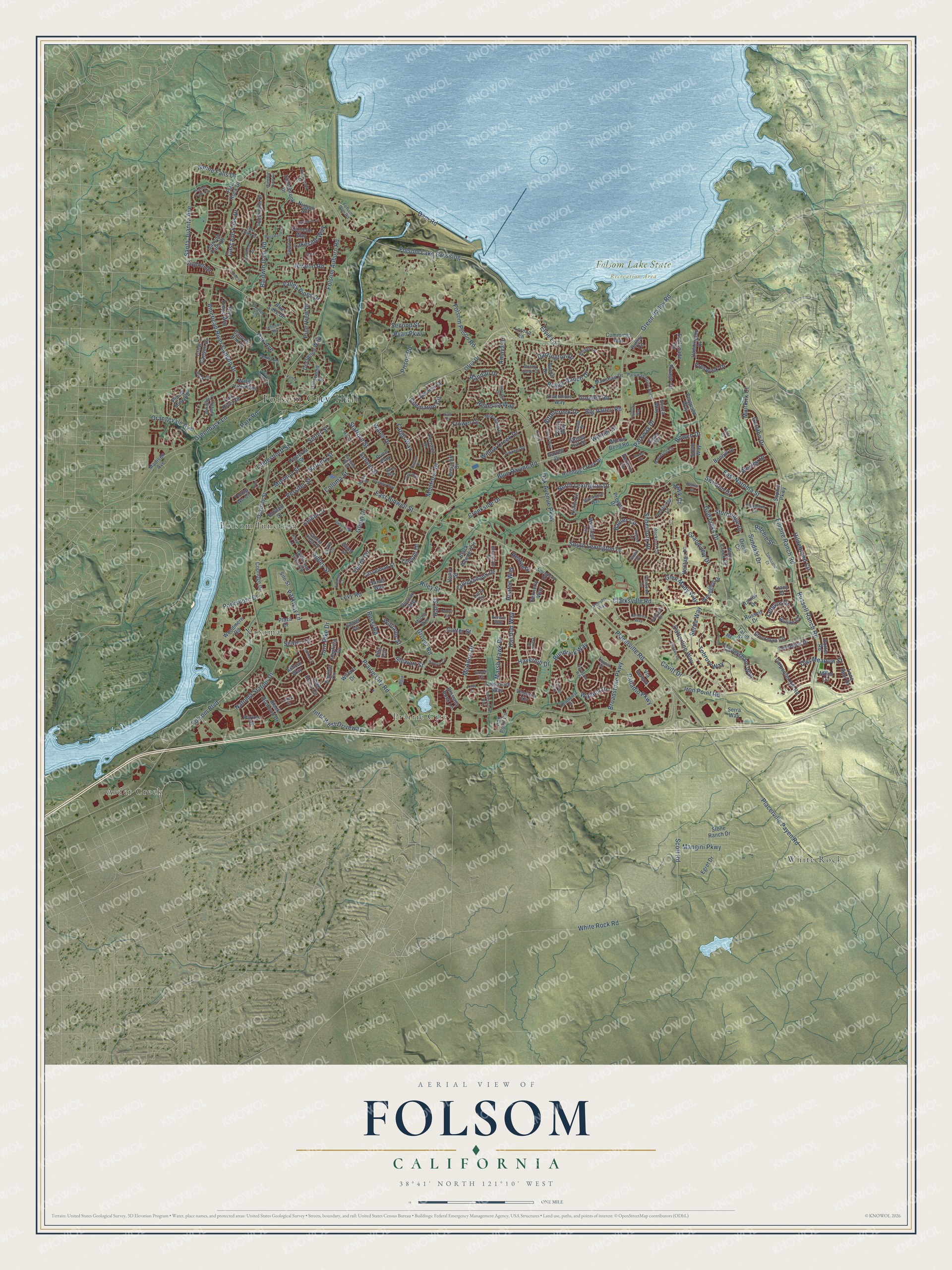
Folsom, California Map Art
Building by building, with labeled streets and shaded relief.
12" x 18" Archival Matte Print
A Map of Home. A Work of Art.
Explore Folsom, California from a whole new perspective. Created using aerial imagery and detailed geographic data, this map captures Folsom building by building, with labeled streets, familiar landmarks, and shaded topographical relief that highlights the natural contours of the landscape.
Combining modern data with the timeless character of a vintage atlas, this map is just as interesting up close as it is beautiful on the wall. Whether you grew up in Folsom, spent memorable years there, or call it home today, this unique map is a great way to celebrate a place that means something to you. Zoom in on the preview to look for your street, and then order a print to put your memories on the wall.
Three ways to hang it

Unframed archival matte, a black wood frame or a white wood frame.
Up close
Geography Worth Displaying
This map was created using accurate cartographic data and authoritative geographic sources, including the U.S. Geological Survey and the Census Bureau. The map brings together terrain, waterways, roads, and building detail. The majority of the streets are labeled, houses are accurately depicted, and the topography is derived from government sources. Combining local data with carefully composed color and shading leads to this beautifully detailed Folsom artwork for your wall.
Rather than simply showing street outlines, we’ve included as many of the street names as we could reasonably fit on the map while keeping their names legible. Zoom in on the high resolution preview to see exactly what’s on the map. We truly set out to create a statement piece for anyone who loves Folsom. So whether it’s for you, or a gift for someone you love, we hope this map of Folsom brings back fond memories.
Read the story behind this map of Folsom, California from 2026.

Find your street
Names on the Folsom map
Every name below is printed on this map. Look for your street, your school, the park where you played, or the pond down the road.
Places and landmarks7
- Folsom City Hall
- Folsom Lake State Recreation Area
- Alder Creek
- White Rock
- Natoma
- Folsom Junction
- Prairie City
Streets and roads286
- East Natoma Street
- Blue Ravine Road
- Green Valley Road
- Caples Drive
- Sibley Street
- Reston Drive
- Parkshore Drive
- Iron Point Road
- Folsom Boulevard
- Oak Avenue Parkway
- White Rock Road
- East Bidwell Street
- American River Canyon Drive
- Prairie City Road
- Placerville Road
- Riley Street
- Broadstone Parkway
- Folsom Auburn Road
- Scott Road
- Folsom Lake Crossing
- Glenn Drive
- Empire Ranch Road
- Greenback Lane
- Russell Ranch Road
- Willow Creek Drive
- Dam Road
- Oak Avenue
- Park Road
- Placerville Payen Road
- Hildebrand Circle
Show all 286 streets
- Cavitt Drive
- Baldwin Dam Road
- Briggs Ranch Drive
- Clarksville Road
- Golf Links Drive
- Halidon Way
- Natoma Street
- Santa Juanita Avenue
- Silberhorn Drive
- Montrose Drive
- Natoma Station Drive
- Russi Road
- Creekside Drive
- Prison Road
- South Lexington Drive
- Parkway Drive
- Tobrury Way
- Flower Drive
- School Street
- Caversham Way
- Mormon Street
- Persifer Street
- Leidesdorff Street
- Cascade Falls Drive
- Wales Drive
- Serpa Way
- McAdoo Drive
- Turn Pike Drive
- Marsh Hawk Drive
- Bittercreek Drive
- Sutter Street
- Randall Drive
- Freswick Drive
- Catterline Way
- Coloma Street
- Big Valley Road
- Baurer Circle
- Walden Drive
- Sundahl Drive
- Vierra Circle
- Lefevre Drive
- Glen Mady Way
- Rebecca Way
- Galston Drive
- Inwood Road
- Levy Road
- Fargo Way
- Valley Pines Drive
- Alpine Falls Drive
- Carter Street
- North Lexington Drive
- Owl Meadow Street
- Folsom Prison Road
- Bowen Drive
- Intel West Driveway
- Parkway Lane
- Ritchie Street
- Cimmaron Circle
- Goodell Road
- Cruickshank Drive
- Lakeside Way
- Grover Road
- Palladio Parkway
- Witmer Drive
- Bundrick Way
- Seaton Drive
- Lembi Drive
- Mangini Parkway
- Wesley Drive
- Sturbridge Drive
- Orangevale Avenue
- Pine View Drive
- Swinton Drive
- Haverhill Drive
- Stewart Street
- Muirkirk Court
- Darrington Drive
- Ryan Parkway
- Grandview Drive
- Hall Street
- Stafford Street
- Heaton Way
- Timson Drive
- Second Street
- Williams Street
- Elvie Lane
- Amaya Drive
- Hawk Court
- Sophia Parkway
- Canyon Falls Drive
- Crow Canyon Drive
- Wellfleet Circle
- Fisher Circle
- John Henry Circle
- Figueroa Street
- Bidwell Street
- Stockman Circle
- Blossom Rock Lane
- Keller Circle
- Esplanade Circle
- Danielle Way
- Briarcliff Drive
- Haddington Drive
- Hillswood Drive
- Willard Drive
- Bayline Circle
- Tomlinson Drive
- Diamond Glen Circle
- Black Powder Circle
- Canyon Rim Drive
- Russell Drive
- Carpenter Hill Road
- Prewett Drive
- Water View Way
- River Ridge Way
- Luna Circle
- Lone Spur Drive
- Oreno Circle
- Plaza Drive
- Souza Way
- Perazzo Circle
- Humbug Creek Drive
- Fenceline Drive
- Heritage Place
- Hopfield Drive
- Stoney Hill Drive
- Ballou Circle
- Black Diamond Drive
- Woodmere Road
- Parker Drive
- Perraud Drive
- Stonebrook Drive
- Moon Circle
- Placer Mine Road
- Porter Road
- Price Way
- Serra Way
- Young Wo Circle
- Manseau Drive
- Plum Creek Court
- Deerwood Way
- Woodglen Drive
- Sands Way
- Rivage Circle
- Willow Bend Road
- Fergusen Way
- Duncan Way
- Cummings Way
- Via Serena
- Ofria Drive
- Casselman Street
- Kennerly Way
- Oakdale Street
- Blue Lake Drive
- Spencer Street
- Fall River Drive
- Ashcat Way
- Nugget Drive
- Smith Way
- Densmore Way
- Livermore Way
- Buljan Court
- Coolidge Drive
- Madison Avenue
- Pepito Way
- Vessona Circle
- Ramos Drive
- Talon Street
- Given Street
- Garrett Drive
- Burrill Drive
- Henry Street
- Flat Rock Drive
- Bonhill Drive
- Ellis Circle
- Silo Street
- Iron Point Circle
- Egret Drive
- Stone Ranch Drive
- Lorena Lane
- Tracy Court
- Albrighton Drive
- Rockport Circle
- Tarbolton Circle
- Scholar Way
- Hillswick Circle
- Lost Creek Drive
- Bluestone Circle
- Winding Canyon Lane
- Singer Lane
- Manasco Circle
- Trowbridge Lane
- Parkway Drive North
- Egloff Circle
- Brock Circle
- Cobble Ridge Drive
- Overbrook Drive
- McFarland Drive
- Stonington Way
- Rumsey Way
- Rowberry Drive
- Larkin Circle
- Gable Street
- Morton Way
- Folsom Dam Road
- Pioneer Drive
- Avon Way
- Buck Circle
- Penwood Lane
- Kidder Way
- Burma Road
- Harter Drive
- Triplet Lane
- Rocky Cove Court
- Freese Court
- Kerwin Way
- Taupin Court
- Swain Square
- Karat Lane
- Brae Court
- Listowe Drive
- Oxburough Drive
- Hancock Drive
- Elkins Circle
- Duchow Way
- Folsom Ranch Drive
- Rugosa Drive
- Townsend Court
- Mosswood Circle
- Raymond Lane
- Market Street
- Feather Falls Circle
- Palmer Circle
- Hansen Circle
- Carmody Circle
- Broder Circle
- Cedar Circle
- Latherton Way
- Hopper Lane
- Thurman Way
- Rundgren Way
- Yankton Street
- Dyrell Way
- Buckingham Way
- Fong Street
- Baldwin Lake Circle
- Corale Way
- Oxleigh Way
- Simmons Way
- Landrise Court
- Belmar Court
- Toney Court
- Mill Street
- Ruth Court
- Vance Lane
- Kirby Court
Names are listed as they appear on the printed map. Zoom into the product photos to find them.
About Folsom, California
Folsom is a city of 80,454 people in Sacramento County, set in the foothills of the Sierra Nevada. The Nisenan people lived here long before outsiders came, and the Gold Rush of 1849 brought them violence, disease and the loss of their land. The ranch called Rancho Rio de los Americanos had belonged to William Alexander Leidesdorff, a San Francisco merchant, and Joseph Libbey Folsom bought it from his heirs. Folsom laid out a town there called Granite City, where most residents were miners hunting for gold.
Few of those miners ever got rich, but the town did well because Folsom pushed hard for a railway linking it to Sacramento. He died in 1855, and the town later took his name. The old rail line was abandoned in the 1980s, then came back to life in 2005 as the end of the Gold Line, the light rail route of the Sacramento Regional Transit District.
“During its first few months, the express mail had been run by pony to and from Sacramento, but beginning July 1, 1860, the Sacramento Valley Railroad carried it between Sacramento and Folsom until Placerville was made the terminus.”
- Loyal to the UnionWhen the Civil War began, Folsom stood firmly with the Union. Residents organized the Granite Guard here on May 27, 1861, and Folsom supplied most of the men in Shirland's company, a cavalry unit within the 1st California Cavalry Regiment.
- Rebuilt after four firesMajor fires swept through Folsom in 1866, 1871 and 1872. Another one in 1886 wiped out much of the business district, and the town built it back up again.
- Electricity sent 22 milesIn 1880 the Livermore family gave the state land for Folsom Prison, and in return they got prison labor to build a dam on the American River for a sawmill. The sawmill failed, but the Livermores saw that the rushing water could make enough power to send to Sacramento. Their powerhouse had the longest overhead electric line in the country when it opened, 22 miles, and it kept running until 1952.
- Folsom Lake since 1956Folsom Dam was finished in 1956 to control floods and secure water for the Sacramento Valley. The water it held back formed Folsom Lake, which now draws crowds for boating, fishing, hiking and biking.
- Folsom Prison BluesJohnny Cash wrote and sang "Folsom Prison Blues" about the state prison on the city's northwest side. The city honored him with the Johnny Cash Trail, a bike path lined with public art, which opened on October 14, 2017.
Keep exploring California
Folsom is one of 1,990 California towns we've mapped. Every dot on the map is a print of its own.
The search covers every state, California first.
Near Folsom
Order 2 or more town maps and save 10%. Shown in the size and finish you picked above, so they hang as a set.
- Orangevale 12" x 18" / Archival Matte Print $39.99
- El Dorado Hills 12" x 18" / Archival Matte Print $39.99
- Fair Oaks 12" x 18" / Archival Matte Print $39.99


More maps nearby: Gold River, Granite Bay, Rancho Cordova, Citrus Heights and Cameron Park.
The art of mapping a place
How This Map Was Made
Real places. Remarkable detail. Discover the layers that turn geographic data into a map of home.

The view from above
Aerial imagery reveals the character of the land: woodland, open fields, and the patterns of a place.

The shape of the land
Elevation data brings hills, valleys, and subtle changes in the landscape into view.

The details of home
Roads, waterways, and building footprints come together to make the map feel unmistakably local.

Geography becomes art
Considered color, shading, and typography bring the layers together in a map made for your wall.


Process illustrated with Mendon, Massachusetts. Aerial imagery: USDA NAIP. Terrain: USGS 3D Elevation Program. Map details and finished artwork: KNOWOL.
The Details
About This Print
Choose an archival matte print, or a black or white Ayous wood frame. The archival matte print is unframed.
Select your size and finish above to see the matching product image and price.
Materials & Craftsmanship
A contemporary map with the character of a classic atlas, printed on archival matte paper. Optional frames are made from Ayous wood.
Your printed map does not include the watermark shown in the full-map preview.
Shipping & Delivery
Free shipping within the United States. Every print is made to order in the USA.
Buying a gift? Add a note in your cart and we'll include it. We never put prices in the package.
Prints ship within 2 to 3 business days. Allow 7 to 10 days total from ordering for delivery. Timing may vary during holidays or periods of high order volume.
Read our shipping policy.
Returns and damaged prints
Each print is made to order. Change-of-mind refunds are not available after production.
If your print arrives damaged, misprinted or incorrect, contact support@knowol.com within 30 days of receiving it. Include your order number, photos and a description of the issue.
Read our full refund and replacement policy. For questions about your order, email support@knowol.com.