


Search for another town


Free U.S. delivery 7 to 10 days after you order
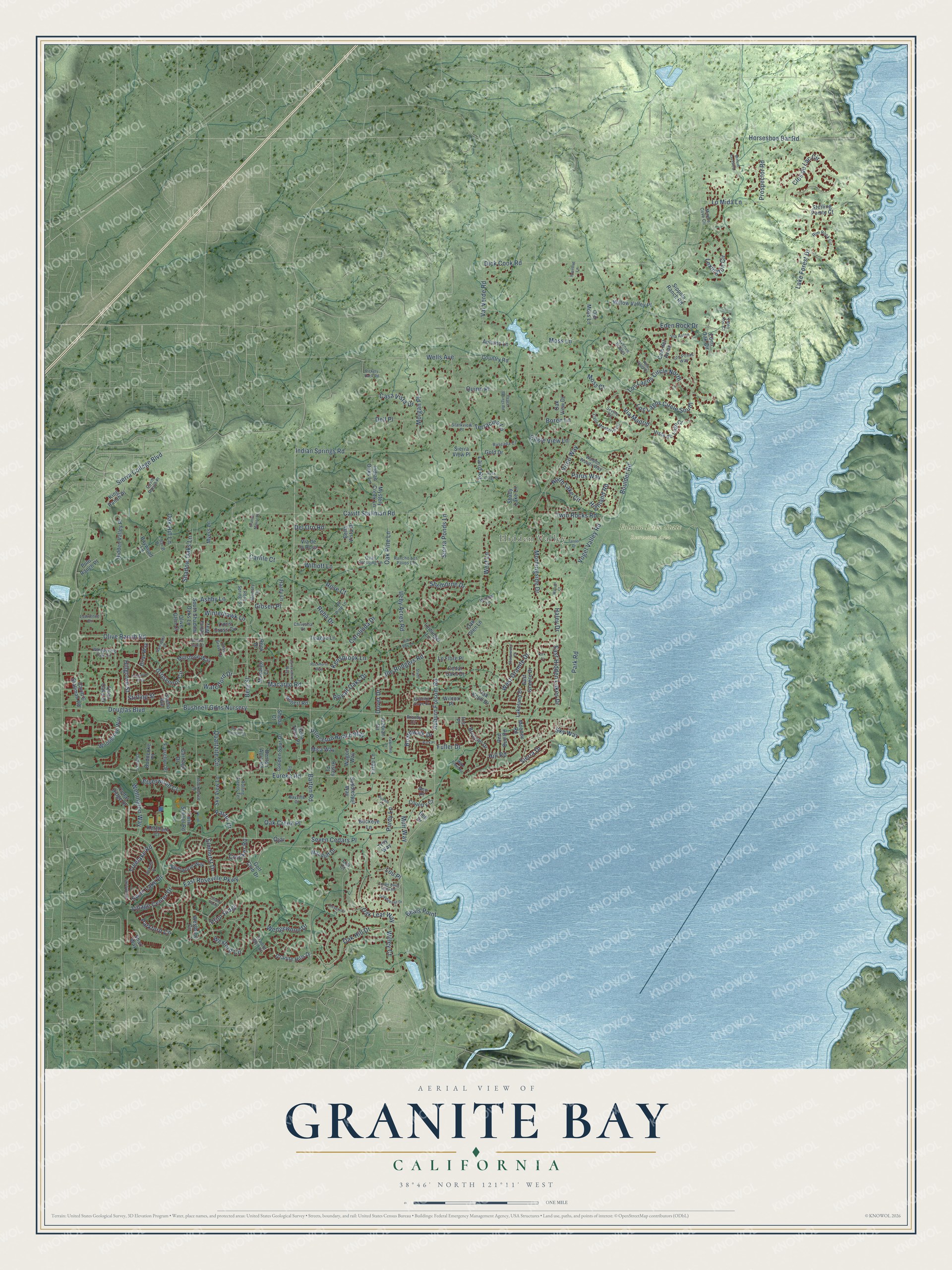
Granite Bay, California Map Art
Building by building, with labeled streets and shaded relief.
12" x 18" Archival Matte Print
A Map of Home. A Work of Art.
Explore Granite Bay, California from a whole new perspective. Created using aerial imagery and detailed geographic data, this map captures Granite Bay building by building, with labeled streets, familiar landmarks, and shaded topographical relief that highlights the natural contours of the landscape.
Combining modern data with the timeless character of a vintage atlas, this map is just as interesting up close as it is beautiful on the wall. Whether you grew up in Granite Bay, spent memorable years there, or call it home today, this unique map is a great way to celebrate a place that means something to you. Zoom in on the preview to look for your street, and then order a print to put your memories on the wall.
Three ways to hang it

Unframed archival matte, a black wood frame or a white wood frame.
Up close
Geography Worth Displaying
This map was created using accurate cartographic data and authoritative geographic sources, including the U.S. Geological Survey and the Census Bureau. The map brings together terrain, waterways, roads, and building detail. The majority of the streets are labeled, houses are accurately depicted, and the topography is derived from government sources. Combining local data with carefully composed color and shading leads to this beautifully detailed Granite Bay artwork for your wall.
Rather than simply showing street outlines, we’ve included as many of the street names as we could reasonably fit on the map while keeping their names legible. Zoom in on the high resolution preview to see exactly what’s on the map. We truly set out to create a statement piece for anyone who loves Granite Bay. So whether it’s for you, or a gift for someone you love, we hope this map of Granite Bay brings back fond memories.
Read the story behind this map of Granite Bay, California from 2026.

Find your street
Names on the Granite Bay map
Every name below is printed on this map. Look for your street, your school, the park where you played, or the pond down the road.
Places and landmarks2
- Hidden Valley
- Folsom Lake State Recreation Area
Streets and roads238
- Barton Road
- Olive Ranch Road
- East Hidden Lakes Drive
- Berg Street
- Bushnell Gdns Nursery
- Park Road
- Oak Hill Drive
- Auburn Folsom Road
- Cavitt Stallman Road
- Douglas Boulevard
- Sierra College Boulevard
- Eureka Road
- Oak Leaf Way
- East Roseville Parkway
- Morningside Drive
- Dick Cook Road
- Laird Road
- Wexford Circle
- Moss Lane
- Los Lagos Circle South
- Swan Lake Drive
- Stirling Street
- Shelborne Drive
- Itchy Acres Road
- Clos du Lac Circle
- Quinn Place
- Horseshoe Bar Road
- Quartzite Circle
- Lake Forest Drive
- Wedgewood Drive
Show all 238 streets
- Hill Road
- Joe Rodgers Road
- Val Verde Road
- Elmhurst Drive
- Wellington Way
- Twin Rocks Road
- West Granite Drive
- Purdy Lane
- Eden Rock Drive
- Indian Springs Road
- Lo Mida Lane
- Crocker Road
- Carolinda Drive
- Sierra Drive
- Los Lagos Circle North
- Oak Pine Lane
- Morgan Place
- Shadow Oaks Lane
- Grosvenor Circle
- Boulder Road
- Reba Drive
- West Lane
- Del Oro Road
- Parkford Circle
- Lexington Circle
- Macargo Road
- Prospector Road
- Boardwalk Drive
- Wells Avenue
- Princeton Reach Way
- Winterhawk Lane
- Vogel Valley Road
- Haley Drive
- Boren Lane
- Carlile Court
- Treelake Road
- Casa Vista Drive
- North Lake Circle
- Village Center Drive
- Gibsen Place
- Via Madrid
- Sierra Ponds Lane
- Terracina Lane
- Wilhoff Lane
- Dover Drive
- Parus Way
- Prior Ridge
- Royall Oaks Drive
- Silverwood Court
- Oak Creek Place
- Dell Place
- Vireo Way
- Seven Cedars Place
- Hillgrove Street
- Fuller Drive
- Beals Point
- Pastor Drive
- Lou Place
- Eagle View Lane
- Rose Court
- Kensbrook Lane
- Waterford Drive
- Highland Road
- Ashby Lane
- Willey Court
- Oak Hill Lane
- Muir Way
- Moss Court
- Sky Way
- Ojai
- Lakeland Drive
- Granite Hills Drive
- Oak Knoll Drive
- Hidden Valley Place
- Bronson Drive
- Golf Club Drive
- Seeno Avenue
- Westbury Circle
- Eden Oak Circle
- Quail Oaks Drive
- Cam del Avion
- Cedar Ridge Drive
- Woodgrove Way
- Arabian Circle
- Buckeye Lane
- Mooney Road
- East Granite Drive
- Sierra View Place
- Shady Lake Lane
- Vista de Lago Court
- Old Moss Lane
- South Shadow Oaks Lane
- Lions Cross Circle
- Bentwood Way
- Macduff Drive
- Red Bud Road
- Golden Spur Drive
- Willow Valley Place
- Troy Way
- Cavitt & Stallman Road
- Macargo Court
- Bella Vista Drive
- Bella Terra Place
- Millstone Way
- Saddlespur Way
- King Ranch Place
- Benton Acre Road
- Sky View Lane
- Indian Oaks Lane
- Baywood Lane
- Via de la Rosa
- Sippola Ranch Road
- Briar Way
- Country Road
- Autumn Lane
- Mystery Creek Lane
- Hardy Lane
- Farschon Place
- Oak Glen Lane
- Leibinger Lane
- Buddecke Place
- Ann Place
- Cedar Oaks Drive
- Sterling Pointe Court
- Sheba Court
- Le Flore Place
- Oak View Drive
- Carriage Drive
- Wagon Way
- Polo Ranch Place
- Olive Glen Court
- Country Court
- Teague Lane
- Robert Road
- Twin School Road
- Ketchum Court
- Mica Way
- Wilcox Place
- Bell Drive
- Gold Drive
- Fargo Lane
- Myers Lane
- Shari Way
- Leona Way
- Risley Place
- Rook Drive
- Lou Court
- Iris Place
- Whispering Oak Circle
- Walden Woods Way
- Rim Rock Circle
- Miners Cove Circle
- Calle Montalvo Circle
- Lawrence Drive
- Granite Cove Drive
- Tall Pine Lane
- Cavitt Ranch Place
- Brandy Circle
- Seville Circle
- Los Posas Way
- Quail Crossing Lane
- Rancho Los Pavos Lane
- Rose Springs Lane
- Stockhorse Lane
- Rolling Greens Terrace
- Ruscada Court
- Starkview Place
- Bayville Court
- Memory Lane
- Christina Court
- Via Avion
- Quail Lane
- Olive Grove Drive
- Avenue Robles
- J-Bar-B Drive
- Granite Glen Court
- Willow Lane
- Eden Roc Court
- Road
- Granite Estates Drive
- Turner Drive
- Dickens Drive
- Cimarron Way
- Cantershire Way
- Rockhurst Way
- Crown Point Vista Road
- Park Place
- Dorchester Lane
- Lake Front Road
- Warren Court
- Ramsgate Drive
- Valle Vista Court
- Sturm Lane
- Woodchase Drive
- Shadowood Court
- Peace Springs Road
- Pueblo Court
- Rosebud Lane
- Miners Crossing
- Rock Crest Place
- Reservoir Court
- Granite Manor Place
- Rickety Rack Road
- Palomino Court
- Willow Gate Court
- Tiffany Point
- Rob Roy Lane
- Kirk Court
Names are listed as they appear on the printed map. Zoom into the product photos to find them.
About Granite Bay, California
From the GraniteBay.com: "Granite Bar, later to be known as Granite Bay was named for the granite rock quarried from its banks and used as rip-rap in the wing dams of Folsom Dam."
Keep exploring California
Granite Bay is one of 1,990 California towns we've mapped. Every dot on the map is a print of its own.
The search covers every state, California first.
Near Granite Bay
Order 2 or more town maps and save 10%. Shown in the size and finish you picked above, so they hang as a set.
- Loomis 12" x 18" / Archival Matte Print $39.99
- Rocklin 12" x 18" / Archival Matte Print $39.99
- Orangevale 12" x 18" / Archival Matte Print $39.99


More maps nearby: Penryn, Folsom, Newcastle, Citrus Heights and Roseville.
The art of mapping a place
How This Map Was Made
Real places. Remarkable detail. Discover the layers that turn geographic data into a map of home.

The view from above
Aerial imagery reveals the character of the land: woodland, open fields, and the patterns of a place.

The shape of the land
Elevation data brings hills, valleys, and subtle changes in the landscape into view.

The details of home
Roads, waterways, and building footprints come together to make the map feel unmistakably local.

Geography becomes art
Considered color, shading, and typography bring the layers together in a map made for your wall.


Process illustrated with Mendon, Massachusetts. Aerial imagery: USDA NAIP. Terrain: USGS 3D Elevation Program. Map details and finished artwork: KNOWOL.
The Details
About This Print
Choose an archival matte print, or a black or white Ayous wood frame. The archival matte print is unframed.
Select your size and finish above to see the matching product image and price.
Materials & Craftsmanship
A contemporary map with the character of a classic atlas, printed on archival matte paper. Optional frames are made from Ayous wood.
Your printed map does not include the watermark shown in the full-map preview.
Shipping & Delivery
Free shipping within the United States. Every print is made to order in the USA.
Buying a gift? Add a note in your cart and we'll include it. We never put prices in the package.
Prints ship within 2 to 3 business days. Allow 7 to 10 days total from ordering for delivery. Timing may vary during holidays or periods of high order volume.
Read our shipping policy.
Returns and damaged prints
Each print is made to order. Change-of-mind refunds are not available after production.
If your print arrives damaged, misprinted or incorrect, contact support@knowol.com within 30 days of receiving it. Include your order number, photos and a description of the issue.
Read our full refund and replacement policy. For questions about your order, email support@knowol.com.