
Search for another town


Free U.S. delivery 7 to 10 days after you order
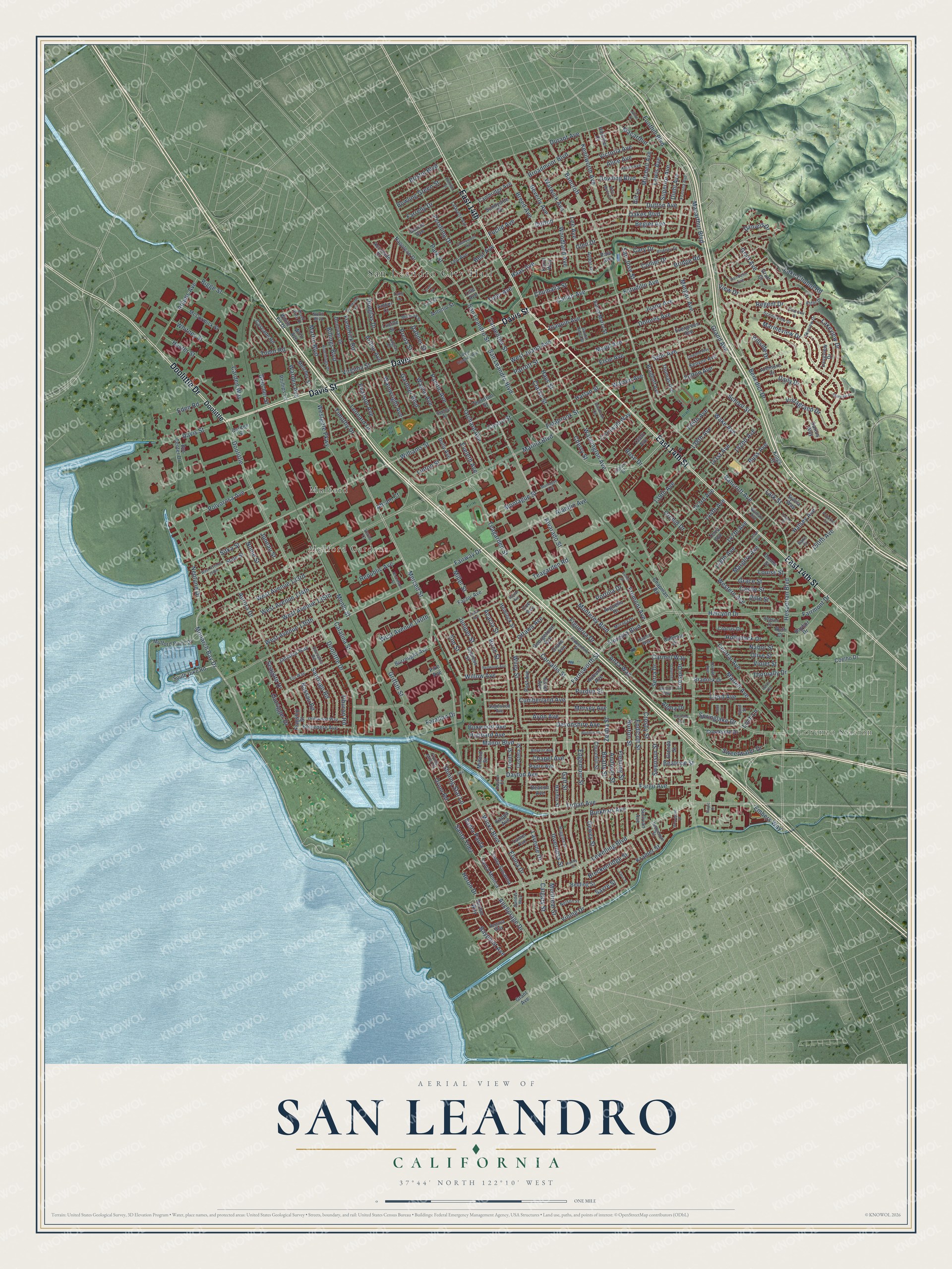
San Leandro, California Map Art
Building by building, with labeled streets and shaded relief.
12" x 18" Archival Matte Print
A Map of Home. A Work of Art.
Explore San Leandro, California from a whole new perspective. Created using aerial imagery and detailed geographic data, this map captures San Leandro building by building, with labeled streets, familiar landmarks, and shaded topographical relief that highlights the natural contours of the landscape.
Combining modern data with the timeless character of a vintage atlas, this map is just as interesting up close as it is beautiful on the wall. Whether you grew up in San Leandro, spent memorable years there, or call it home today, this unique map is a great way to celebrate a place that means something to you. Zoom in on the preview to look for your street, and then order a print to put your memories on the wall.
Three ways to hang it

Unframed archival matte, a black wood frame or a white wood frame.
Up close
Geography Worth Displaying
This map was created using accurate cartographic data and authoritative geographic sources, including the U.S. Geological Survey and the Census Bureau. The map brings together terrain, waterways, roads, and building detail. The majority of the streets are labeled, houses are accurately depicted, and the topography is derived from government sources. Combining local data with carefully composed color and shading leads to this beautifully detailed San Leandro artwork for your wall.
Rather than simply showing street outlines, we’ve included as many of the street names as we could reasonably fit on the map while keeping their names legible. Zoom in on the high resolution preview to see exactly what’s on the map. We truly set out to create a statement piece for anyone who loves San Leandro. So whether it’s for you, or a gift for someone you love, we hope this map of San Leandro brings back fond memories.
Read the story behind this map of San Leandro, California from 2026.

Find your street
Names on the San Leandro map
Every name below is printed on this map. Look for your street, your school, the park where you played, or the pond down the road.
Places and landmarks4
- San Leandro City Hall
- Lorenzo Station
- Mulford
- Mulford Gardens
Streets and roads395
- Davis Street
- East 14th Street
- Davis
- East 14th
- Doolittle Drive
- Alvarado Street
- Farnsworth Street
- Merced Street
- Monarch Bay Drive
- Grand Avenue
- Macarthur Boulevard
- Fremont Avenue
- Dutton
- Willow Avenue
- Juniper Street
- Floresta Boulevard
- Callan Avenue
- Martin Boulevard
- Bancroft Avenue
- Halcyon Drive
- Benedict Drive
- Joaquin Avenue
- Bristol Boulevard
- Euclid Avenue
- Wicks Boulevard
- Lewelling Boulevard
- Bancroft
- Washington Avenue
- Williams Street
- Marina Boulevard
Show all 395 streets
- Fairway Drive
- Hesperian Boulevard
- Manor Boulevard
- San Leandro Boulevard
- Fargo Avenue
- San Leandro Street
- Estudillo Avenue
- Neptune Drive
- Teagarden Street
- Farallon Drive
- Sybil Avenue
- Castro Street
- Dutton Avenue
- Wiley Street
- Oakes Boulevard
- Durant Avenue
- Lake Chabot Road
- Springlake Drive
- Aurora Drive
- Aladdin Avenue
- Begier Avenue
- Broadmoor Boulevard
- Dowling Boulevard
- Inverness Street
- Juana Avenue
- Monterey Boulevard
- Burkhart Avenue
- Lark Street
- Parrott Street
- Marineview Drive
- Wake Avenue
- 139th Avenue
- Purdue Street
- Dolores Avenue
- Pershing Drive
- Wayne Avenue
- Corvallis Street
- Maud Avenue
- Dayton Avenue
- 143rd Avenue
- Glen Drive
- Edgemoor Street
- Crosby Street
- Clarke Street
- Pacific Avenue
- Orchard Avenue
- Catalina Street
- West Avenue 133rd
- 136th Avenue
- Timothy Drive
- Norton Street
- Anza Way
- Estabrook Street
- 148th Avenue
- West Juana Avenue
- Harlan Street
- West Avenue 134th
- 141st Avenue
- Acacia Street
- Menlo Street
- Trojan Avenue
- Lakeview Drive
- Haas Avenue
- View Drive
- Andover Street
- Warden Avenue
- Laverne Drive
- School Street
- Devonshire Avenue
- Carpentier Street
- Beatty Street
- Westgate Parkway
- Leonard Drive
- Elsie Avenue
- Hubbard Avenue
- Vining Drive
- Fairmont Drive
- 150th Avenue
- Hays Street
- San Jose Street
- Teagarden Road
- Cumberland Avenue
- Mersey Avenue
- West Avenue 136th
- West Avenue 135th
- Dewey Street
- Avon Avenue
- Montague Street
- Heron Drive
- Figueroa Drive
- Collier Drive
- Lee Avenue
- Elvina Drive
- Western Avenue
- Sweetwater Drive
- 138th Avenue
- Graff Avenue
- Adams Avenue
- Kenilworth Avenue
- Superior Avenue
- Anchorage Drive
- Hollyhock Drive
- Warwick Avenue
- Vistagrand Drive
- Tudor Road
- Beverly Avenue
- Victoria Avenue
- Santiago Road
- Breed Avenue
- Bridge Road
- Morgan Avenue
- Gardner Boulevard
- Douglas Drive
- Shining Star Lane
- Thornally Drive
- Park Street
- 142nd Avenue
- Foothill Boulevard
- Preda Street
- Central Avenue
- Rose Drive
- Santa Paula
- Endicott Street
- Arthur Avenue
- Seagate Drive
- Eveleth Avenue
- Portola Drive
- Carmel Way
- 147th Avenue
- Macarthur
- Farrelly Drive
- Polvorosa Avenue
- Frederick Road
- Grace Street
- Tiburon Road
- Billings Boulevard
- Outrigger Drive
- Mitchell Avenue
- Doolittle
- Kramer Street
- Olive Street
- Bigge Street
- Sitka Street
- Best Avenue
- Swenson Street
- Birch Street
- Martell Avenue
- West Avenue 140th
- Carden Way
- Nabor Street
- Loch Lane
- Bowling Green Street
- Pearson Avenue
- Lloyd Avenue
- Baypoint Avenue
- Virginia Street
- Ottawa Avenue
- Lewis Avenue
- Elm Street
- Cornwall Way
- Boxwood Avenue
- Breckenridge Street
- Wainwright Avenue
- Margery Avenue
- Hillside Drive
- Zelma Street
- Hester Street
- Regent Drive
- Woodland Avenue
- Nome Street
- Griffith Street
- Calgary Street
- Republic Avenue
- Alice Avenue
- Dillo Street
- Fulton Avenue
- Linton Street
- Whitney Street
- Chumalia Street
- Fleming Street
- Daily Drive
- Chapel Avenue
- Halsey Avenue
- Cary Drive
- Serra Drive
- Castle Street
- Violet Street
- Santa Ynez
- Diehl Avenue
- Montreal Street
- Eden Road
- Embers Way
- Warren Avenue
- Nassau Road
- Daniels Drive
- Sayre Street
- Beecher Street
- Miller Street
- Cherry Street
- 144th Avenue
- Aloha Drive
- Russ Avenue
- Galt Street
- Crespi Drive
- Beatrice Street
- Dabner Street
- Toler Avenue
- Louise Street
- Orchid Drive
- Juneau Street
- Orion Road
- Abram Court
- Napoleon Drive
- Thornton Street
- Evergreen Avenue
- South Dike Road
- Mulford Point Drive
- Churchill Street
- Santa Susanna
- Longview Drive
- Santa Monica
- Drake Avenue
- Garcia Avenue
- Bayfair Drive
- Donovan Drive
- Esser Avenue
- Arbor Drive
- Arguello Drive
- Cypress Street
- Belvedere Avenue
- Sylvia Way
- Sunnyside Drive
- Accolade Drive
- McCormick Street
- Cambridge Avenue
- Belding Street
- Lucille Street
- Leo Avenue
- Cascade Road
- Donna Street
- Amber Court
- Creekside Drive
- Burroughs Avenue
- Jamaica Way
- Bradrick Drive
- Hemlock Street
- Darius Way
- Melcher Street
- Caliente Drive
- Bradhoff Avenue
- Santa Maria Street
- Kenyon Avenue
- Post Avenue
- Thomas Avenue
- Ardmore Drive
- Hardin Street
- Harbor Way
- Thoits Street
- Costela Street
- Flagship Street
- 135th Avenue
- Bus Center Drive
- Georgetown Avenue
- Factor Avenue
- Pala Avenue
- Chapman Road
- Lanier Avenue
- Hollister Court
- Auburn Avenue
- Gill Lane
- Padre Avenue
- Antonio Street
- Phillips Lane
- Carden Street
- Coelho Drive
- Kings Court
- Milford Street
- Crocus Drive
- Dolly Avenue
- White Fir Drive
- Beacon Avenue
- Terra Avenue
- Grenda Street
- Sullivan Avenue
- Grant Avenue
- Wrin Avenue
- State Street
- Kappa Avenue
- Karol Way
- Coe Avenue
- Ruth Court
- Pike Avenue
- Lille Avenue
- Graff Court
- North Boulevard
- Lafayette Avenue
- Sandelin Avenue
- Scenicview Drive
- Sandev Way
- Rodney Drive
- Hutchings Drive
- Santa Rosa Street
- Ruggles Street
- Fiji Way
- Minerva Street
- Driftwood Way
- Adason Drive
- Harold Avenue
- Douglas Court
- Moraga Drive
- Fortuna Avenue
- Helen Avenue
- Skyview Drive
- Regatta Way
- Advent Avenue
- Black Pine Drive
- Pepperdine Street
- Sagewood Avenue
- Flying Mist Road
- Coburn Court
- Astor Drive
- Sedgeman Street
- Nelson Street
- Sausalito Road
- Fjord Street
- Rake Court
- Wyman Avenue
- Dayton Court
- Lola Street
- Hamlin Way
- Seeley Street
- Tulip Lane
- Verna Court
- Sutter Street
- West Merle Court
- Faris Street
- Montague Avenue
- West Estudillo Avenue
- Cedar Avenue
- Lillian Avenue
- Cherrywood Avenue
- Portofino Circle
- Upton Avenue
- Randy Street
- Brookside Drive
- West Avenue 130th
- Lasuen Drive
- Woodgate Drive
- Linwood Way
- Pontiac Street
- Clearview Drive
- Nicholson Street
- Bodmin Avenue
- Mission Way
- Jasmine Way
- Redwood Avenue
- Starview Drive
- Towers Street
- Estabrook Circle
- Julius Street
- Tivoli Street
- Sea
- Inlet Court
- Tropic Court
- Baylor Avenue
Names are listed as they appear on the printed map. Zoom into the product photos to find them.
About San Leandro, California
San Leandro is a city of 91,008 people in Alameda County, on the east side of San Francisco Bay. The first Europeans to reach this ground were the soldier Captain Pedro Fages and the priest Father Crespi, who came through on March 20, 1772. The city's name honors Leander of Seville, a Spanish bishop of the sixth century.
The land here came from two Mexican grants along El Camino Viejo, the old road that is now East 14th Street. Don Luis Maria Peralta received Rancho San Antonio, about 44,000 acres, in 1820, and José Joaquín Estudillo received Rancho San Leandro, about 9,000 acres, in 1842. Starting in 1855, John B. Ward and William Heath Davis, who had married into the Estudillo family, laid out a townsite south of San Leandro Creek, and in 1856 the new town became the county seat.
“Site of the last home, built about 1850, of José Joaquín Estudillo, grantee of Rancho San Leandro, and his wife, Juana Martínez de Estudillo.”
- A courthouse lost in 1868San Leandro held the Alameda County seat until the 1868 earthquake on the Hayward Fault wrecked its courthouse. In 1872 the county moved its seat to Brooklyn, a town that is now part of Oakland. The fault still runs beneath Foothill Boulevard.
- A Portuguese town by 1910In the 1880s, Portuguese workers from Hawaii and the Azores began settling in San Leandro, where they started farms and businesses. By the 1910 census they made up nearly two-thirds of the town's people.
- From all-white to no majorityAfter World War II, deed covenants here kept owners from selling homes to African Americans and other minorities, and in 1960 the city was 99.3% white. The comedian Brian Copeland, who moved here in 1972, wrote about that time in Not a Genuine Black Man. The city began to diversify in the 1980s, and by 2010 Asian Americans were its largest group, about one-third of residents.
- Lloyd Bridges and Tony LemaThe film and television actor Lloyd Bridges was born in San Leandro on January 15, 1913. The golfer Tony Lema moved here in 1940 at age six, and the city dedicated the Tony Lema Golf Course in his honor in June 1983.
Keep exploring California
San Leandro is one of 1,990 California towns we've mapped. Every dot on the map is a print of its own.
The search covers every state, California first.
Near San Leandro
Order 2 or more town maps and save 10%. Shown in the size and finish you picked above, so they hang as a set.
- Mulford Gardens 12" x 18" / Archival Matte Print $39.99
- San Lorenzo 12" x 18" / Archival Matte Print $39.99
- Brookfield Village 12" x 18" / Archival Matte Print $39.99


More maps nearby: Ashland, Cherryland, Eastmont, Millsmont and Castro Valley.
The art of mapping a place
How This Map Was Made
Real places. Remarkable detail. Discover the layers that turn geographic data into a map of home.

The view from above
Aerial imagery reveals the character of the land: woodland, open fields, and the patterns of a place.

The shape of the land
Elevation data brings hills, valleys, and subtle changes in the landscape into view.

The details of home
Roads, waterways, and building footprints come together to make the map feel unmistakably local.

Geography becomes art
Considered color, shading, and typography bring the layers together in a map made for your wall.


Process illustrated with Mendon, Massachusetts. Aerial imagery: USDA NAIP. Terrain: USGS 3D Elevation Program. Map details and finished artwork: KNOWOL.
The Details
About This Print
Choose an archival matte print, or a black or white Ayous wood frame. The archival matte print is unframed.
Select your size and finish above to see the matching product image and price.
Materials & Craftsmanship
A contemporary map with the character of a classic atlas, printed on archival matte paper. Optional frames are made from Ayous wood.
Your printed map does not include the watermark shown in the full-map preview.
Shipping & Delivery
Free shipping within the United States. Every print is made to order in the USA.
Buying a gift? Add a note in your cart and we'll include it. We never put prices in the package.
Prints ship within 2 to 3 business days. Allow 7 to 10 days total from ordering for delivery. Timing may vary during holidays or periods of high order volume.
Read our shipping policy.
Returns and damaged prints
Each print is made to order. Change-of-mind refunds are not available after production.
If your print arrives damaged, misprinted or incorrect, contact support@knowol.com within 30 days of receiving it. Include your order number, photos and a description of the issue.
Read our full refund and replacement policy. For questions about your order, email support@knowol.com.