
Search for another town


Free U.S. delivery 7 to 10 days after you order
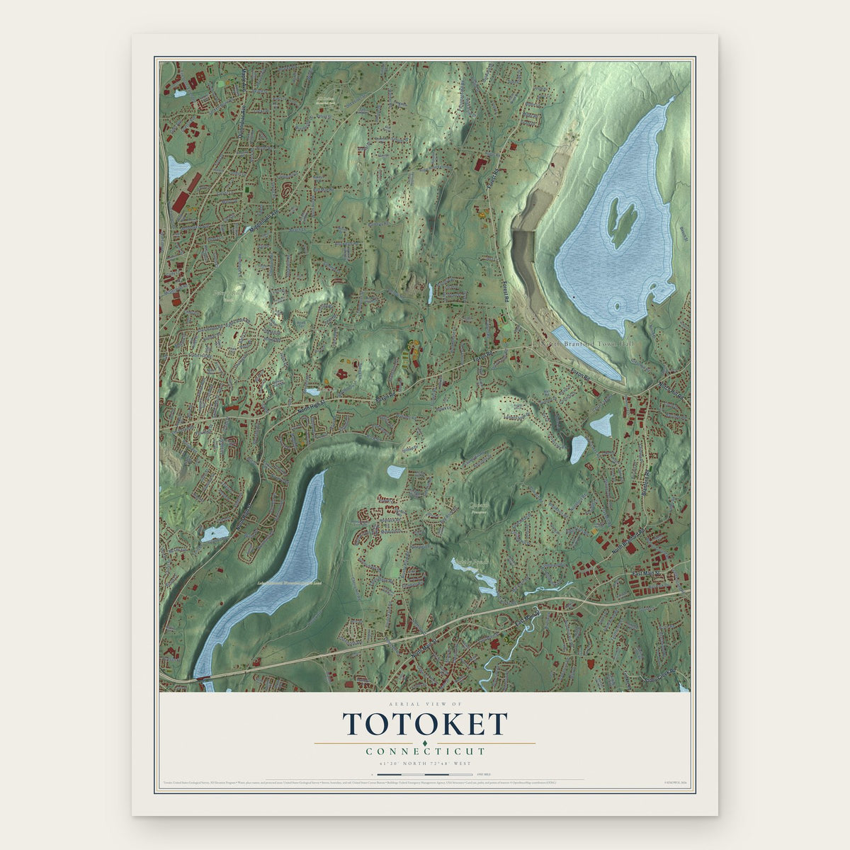
Totoket, Connecticut Map Art
Building by building, with labeled streets and shaded relief.
12" x 18" Archival Matte Print
A Map of Home. A Work of Art.
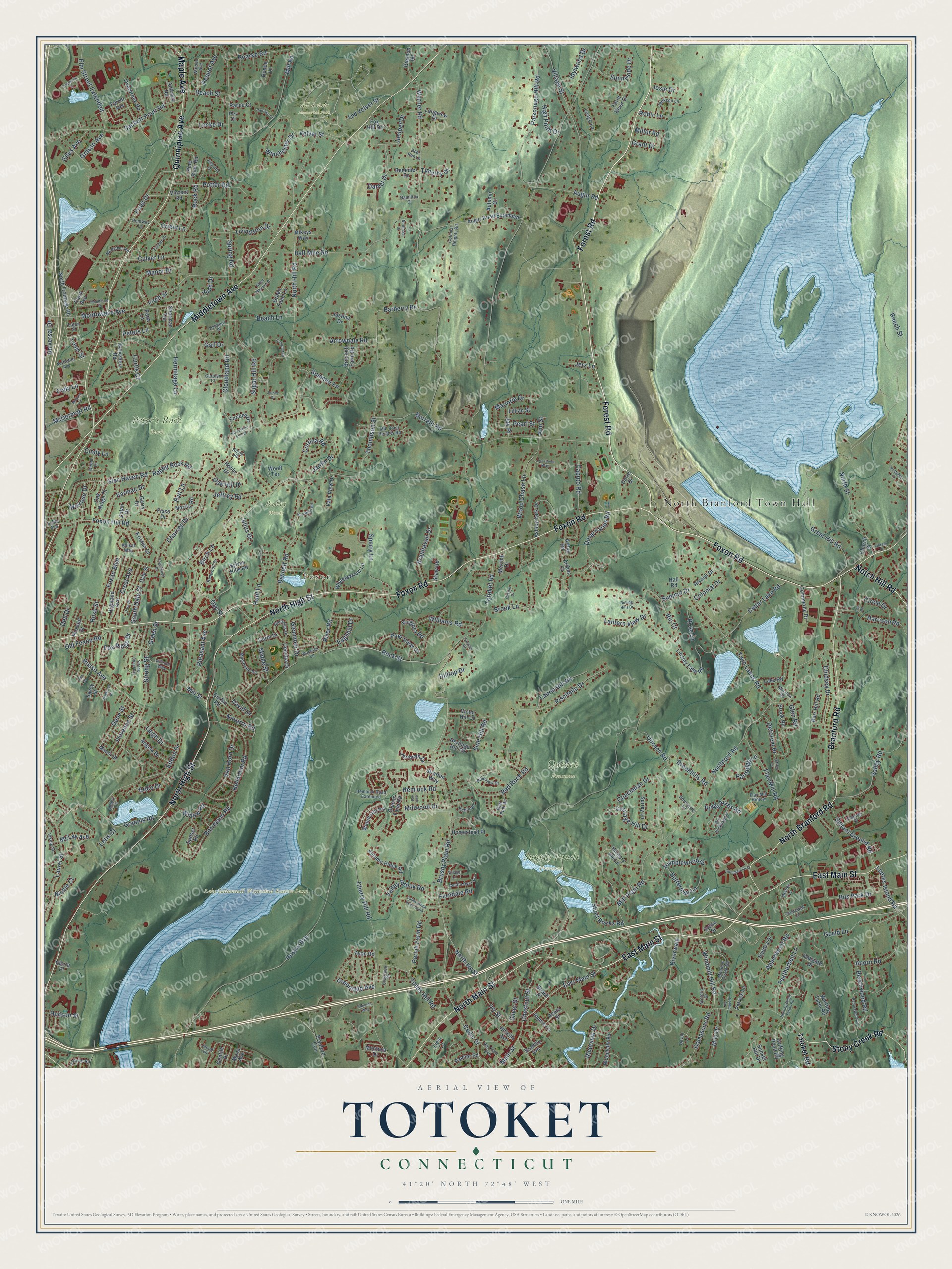
Explore Totoket, Connecticut from a whole new perspective. Created using aerial imagery and detailed geographic data, this map captures Totoket building by building, with labeled streets, familiar landmarks, and shaded topographical relief that highlights the natural contours of the landscape.
Combining modern data with the timeless character of a vintage atlas, this map is just as interesting up close as it is beautiful on the wall. Whether you grew up in Totoket, spent memorable years there, or call it home today, this unique map is a great way to celebrate a place that means something to you. Zoom in on the preview to look for your street, and then order a print to put your memories on the wall.
Three ways to hang it

Unframed archival matte, a black wood frame or a white wood frame.
Up close
Geography Worth Displaying
This map was created using accurate cartographic data and authoritative geographic sources, including the U.S. Geological Survey and the Census Bureau. The map brings together terrain, waterways, roads, and building detail. The majority of the streets are labeled, houses are accurately depicted, and the topography is derived from government sources. Combining local data with carefully composed color and shading leads to this beautifully detailed Totoket artwork for your wall.
Rather than simply showing street outlines, we’ve included as many of the street names as we could reasonably fit on the map while keeping their names legible. Zoom in on the high resolution preview to see exactly what’s on the map. We truly set out to create a statement piece for anyone who loves Totoket. So whether it’s for you, or a gift for someone you love, we hope this map of Totoket brings back fond memories.
Read the story behind this map: Detailed Map of Totoket, Connecticut.

Find your street
Names on the Totoket map
Every name below is printed on this map. Look for your street, your school, the park where you played, or the pond down the road.
Places and landmarks8
- North Branford Town Hall
- Foxon
- All Saints Memorial Park
- Bailey Woods
- Lake Saltonstall Watershed Reserve Land
- Peter's Rock Park
- Queach Preserve
- Supply Ponds Preserve
Streets and roads363
- East Main Street
- Forest Road
- Foxon Road
- Middletown Avenue
- North High Street
- Quinnipiac Avenue
- North Main Street
- Branford Road
- Stony Creek Road
- North Branford Road
- Maple Avenue
- Notch Hill Road
- Windmill Hill Road
- Millwood Drive
- Rock Street
- Brushy Plain Road
- Elm Street Extended
- Rock Road
- Chestnut Street
- Grasso Avenue
- Warner Road
- North Ivy Street
- River Road
- Totoket Road
- Thompson Street
- Hosley Avenue
- Twin Lakes Road
- Mill Road
- Cherry Hill Road
- Strong Street
Show all 363 streets
- Spring Road
- North Hill Road
- Village Street
- Half Mile Road
- Laurel Hill Road
- Summer Lane
- Queach Road
- Montowese Avenue
- Barberry Road
- Damascus Road
- North Street
- Northford Road
- Parsonage Hill Road
- Hellstrom Road
- Foxon Hill Road
- Sackett Point Road
- Sugar Hill Road
- Cloudland Road
- Fitch Street
- Cedar Street
- Charnes Drive
- Mill Plain Road
- Featherbed Lane
- Valley Road
- Borrmann Road
- Laurel Street
- Riverwalk
- Grannis Road
- Bennett Road
- Hemlock Road
- Summit Drive
- Wood Chase Lane
- Gould Lane
- Brook Lane
- Glen Haven Road
- Short Rocks Road
- Borrelli Road
- Sunnyside Drive
- Russo Avenue
- Rose Street
- Velvet Street
- Glenmoor Drive
- Todds Hill Road
- Sperry Lane
- Rabbit Rock Road
- Mill Street
- Frost Drive
- Flax Mill Road
- Circle Drive
- Maple Street
- Applewood Road
- Foxon Boulevard
- Arrowdale Road
- Piscitello Drive
- Riverside Drive
- Culver Lane
- Deforest Drive
- McDermott Road
- Bus Park Drive
- Cedar Lake Road
- Parish Farm Road
- School Ground Road
- Marjorie Drive
- Cortina Road
- Acorn Road
- Hunt Lane
- Doral Farms Road
- Harrison Road
- Willow Road
- Beechwood Road
- Caputo Road
- Ramblewood Drive
- McLay Avenue
- Van Horn Drive
- Eddon Drive
- Leetes Island Road
- Chidsey Drive
- Manor Drive
- Harmac Drive
- Great Hill Road
- Red Rock Road
- Crest Avenue
- Juniper Drive
- Valley Brook Road
- Roarke Road
- Williams Road
- Buttermilk Lane
- Greenfield Avenue
- Beach Lane
- Batt Lane
- David Drive
- Colonial Drive
- Jeffrey Road
- Winchester Drive
- Augur Road
- Jardin Drive
- Daniel Drive
- Universal Drive
- Gail Drive
- Old Foxon Road
- Carriage Hill Drive
- Branhaven Drive
- Brookhills Road
- Hermitage Lane
- Coachman Drive
- Florence Street
- Pleasant Avenue
- Potter Road
- Gay Street
- Gene Street
- Ric Court
- Main Street
- Pine View Drive
- Ivy Street
- Old Velvet Street
- Livingston Drive
- Milo Drive
- Navarro Road
- Leigh Drive
- Idylwood Drive
- Ann Street
- Pequot Avenue
- Ridge Acres Road
- Virginia Road
- Lantern View Drive
- Edgehill Drive
- Beach Street
- Fox Ridge Drive
- Rose Lane
- Grant Drive
- Giles Avenue
- Glen Road
- High Point Drive
- South Dale Street
- Peters Lane
- Oak Hill Drive
- Locke Drive
- Ferndale Road
- Melrose Drive
- Partridge Lane
- Dell Drive
- Orient Lane
- Side Hill Road
- Birch Lane
- Jay Place
- Beech Street
- Hudson Street
- Hilltop Drive
- Pearl Street
- Erico Drive
- Josie Drive
- Letis Court
- Cody Lane
- Timothy Drive
- Green Street
- Robin Lane
- Julius Drive
- Nicole Court
- Jerz Lane
- Miller Road
- Curtis Court
- Cindy Lane
- Silver Street
- Louis Street
- Judd Drive
- Belvedere Road
- Greens Farm Road
- Griffing Pond Road
- Linsley Lake Road
- Hickory Hill Lane
- Highland Avenue
- Angela Drive
- Montoya Drive
- Benedict Drive
- Sylvan Hills Road
- Ashley Park Drive
- Sunset Road
- Clark Avenue
- Palmer Road
- Augur Road Extended
- Arthur Road
- Sunset Hill Drive
- Avon Road
- Patrick Lane
- Autumn Ridge Road
- Fisco Drive
- Brockett Farm Road
- Woodvale Road
- Watch Hill Road
- Whiting Farm Road
- Burr Hill Road
- North Frontage Road
- Pine River Road
- Overbrook Road
- Liesl Lane
- Lake Road
- Wheelbarrow Lane
- Surrey Lane
- Justine Drive
- Kristen Court
- Heritage Hill Road
- Farm River Drive
- Hillside Avenue
- Victor Hill Drive
- Commerce Drive
- Sandra Drive
- Rimmon Road
- Fox Hill Drive
- Garry Drive
- Homestead Place
- Church Street
- Corbin Road
- Jerimoth Drive
- Green Field Lane
- Branford Con
- Oakgate Drive
- Michael Street
- Vale View Drive
- Rance Court
- Lillian Street
- Rivaldi Drive
- Wood Terrace
- Fortune Drive
- Renee Lane
- Longview Drive
- Cecelia Drive
- Morris Road
- Oak Ridge Drive
- Arthur Court
- Vincent Road
- Autumn Court
- Savoy Street
- Robin Drive
- Sherman Terrace
- Gentile Place
- Hamre Lane
- Brook Road
- Longo Lane
- Merrick Drive
- Miami Street
- Mona Avenue
- Anthony Road
- Aceto Street
- Dale Street
- Papa Lane
- Shaw Road
- Mikeys Way
- Stratton Way
- Dorie Drive
- Carol Drive
- Sylvia Street
- Bradley Avenue
- Zolan Drive
- Hall Road
- Gloria Place
- Forest Avenue
- Beach Place
- Pez Court
- Old Hickory Lane
- Maplevale Road
- Allison Way
- Mill Pond Heights Road
- Ansonia Drive
- Meadow Circle Road
- Richill Road
- Nicholas Drive
- Redwood Drive
- Flax Mill Hollow
- Debra Lane
- Turner Drive
- Austin Ryer Lane
- Hemlock Road Extended
- Nettleton Avenue
- Dorchester Lane
- Watson Avenue
- McArthur Road
- Harrison Avenue
- Jackson Lane
- Allikat Way
- Medley Lane
- Victoria Drive
- Pineview Drive
- Meadow Road
- Estelle Road
- Warwick Lane
- Viking Street
- Colonial Heights Road
- Tipping Drive
- Bear Path Road
- Carolyn Court
- Hamilton Court
- Stonewall Lane
- Cosgrove Court
- Palmieri Place
- Pentway Lane
- Robby Lane
- Hiltop Road
- Jacob Lane
- Devon Lane
- Deer Run Lane
- Smith Avenue
- Eaton Street
- Hunting Ridge Farms Road
- Pepperwood Lane
- Strong Street Extension
- McMahon Lane
- Moulthrop Street
- John Street
- Great Meadow Drive
- Horseshoe Hill Road
- Pinehurst Drive
- Englewood Drive
- Commercial Street
- Corporate Drive
- Valley Brook Road South
- Joe Stone Way
- Dora Drive
- Pierpont Court
- Red Bluff Road
- Conhurst Drive
- Mallard Lane
- Village Lane
- Ash Road
- Oakhill Drive
- Library Place
- Northeast Drive
- Jeffrey Lane
- Ramona Way
- Lea Road
- Farview Drive
- Rolling Hills Drive
- Corbin Circle
- Jersey Drive
Names are listed as they appear on the printed map. Zoom into the product photos to find them.
Keep exploring Connecticut
Totoket is one of 382 Connecticut towns we've mapped. Every dot on the map is a print of its own.
The search covers every state, Connecticut first.
Near Totoket
Order 2 or more town maps and save 10%. Shown in the size and finish you picked above, so they hang as a set.
- North Branford 12" x 18" / Archival Matte Print $39.99
- East Haven 12" x 18" / Archival Matte Print $39.99
- Quinnipiac Meadows 12" x 18" / Archival Matte Print $39.99

More maps nearby: Branford Center, Branford, Fair Haven Heights, North Haven and Fair Haven.
The art of mapping a place
How This Map Was Made
Real places. Remarkable detail. Discover the layers that turn geographic data into a map of home.

The view from above
Aerial imagery reveals the character of the land: woodland, open fields, and the patterns of a place.

The shape of the land
Elevation data brings hills, valleys, and subtle changes in the landscape into view.

The details of home
Roads, waterways, and building footprints come together to make the map feel unmistakably local.

Geography becomes art
Considered color, shading, and typography bring the layers together in a map made for your wall.


Process illustrated with Mendon, Massachusetts. Aerial imagery: USDA NAIP. Terrain: USGS 3D Elevation Program. Map details and finished artwork: KNOWOL.
The Details
About This Print
Choose an archival matte print, or a black or white Ayous wood frame. The archival matte print is unframed.
Select your size and finish above to see the matching product image and price.
Materials & Craftsmanship
A contemporary map with the character of a classic atlas, printed on archival matte paper. Optional frames are made from Ayous wood.
Your printed map does not include the watermark shown in the full-map preview.
Shipping & Delivery
Free shipping within the United States. Every print is made to order in the USA.
Buying a gift? Add a note in your cart and we'll include it. We never put prices in the package.
Prints ship within 2 to 3 business days. Allow 7 to 10 days total from ordering for delivery. Timing may vary during holidays or periods of high order volume.
Read our shipping policy.
Returns and damaged prints
Each print is made to order. Change-of-mind refunds are not available after production.
If your print arrives damaged, misprinted or incorrect, contact support@knowol.com within 30 days of receiving it. Include your order number, photos and a description of the issue.
Read our full refund and replacement policy. For questions about your order, email support@knowol.com.