


Search for another town



Free U.S. delivery 7 to 10 days after you order
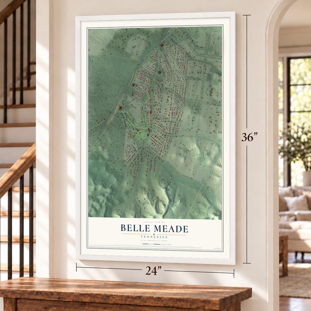
Belle Meade, Tennessee Map Art
Building by building, with labeled streets and shaded relief.
12" x 18" Archival Matte Print
A Map of Home. A Work of Art.
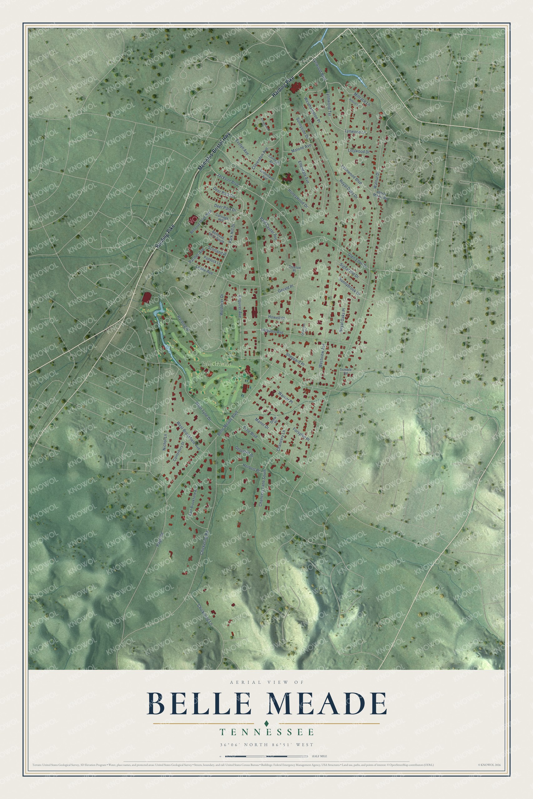
Explore Belle Meade, Tennessee from a whole new perspective. Created using aerial imagery and detailed geographic data, this map captures Belle Meade building by building, with labeled streets, familiar landmarks, and shaded topographical relief that highlights the natural contours of the landscape.
Combining modern data with the timeless character of a vintage atlas, this map is just as interesting up close as it is beautiful on the wall. Whether you grew up in Belle Meade, spent memorable years there, or call it home today, this unique map is a great way to celebrate a place that means something to you. Zoom in on the preview to look for your street, and then order a print to put your memories on the wall.
Three ways to hang it
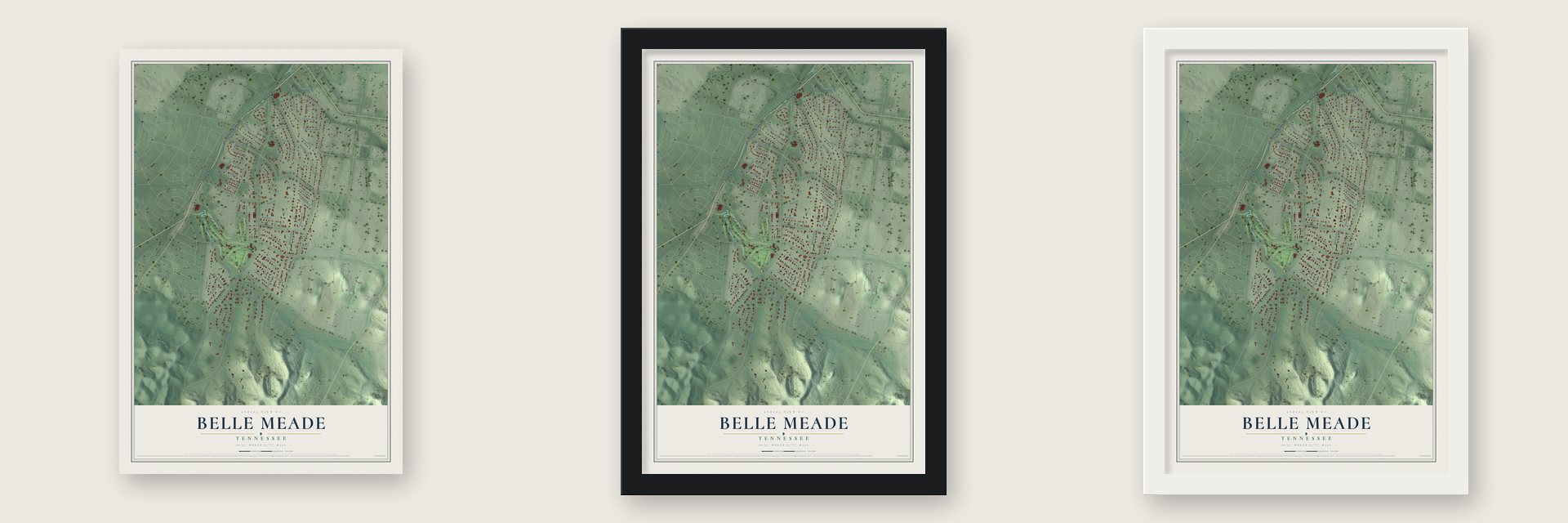
Unframed archival matte, a black wood frame or a white wood frame.
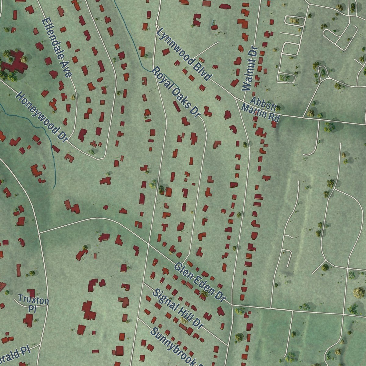
Up close
Geography Worth Displaying
This map was created using accurate cartographic data and authoritative geographic sources, including the U.S. Geological Survey and the Census Bureau. The map brings together terrain, waterways, roads, and building detail. The majority of the streets are labeled, houses are accurately depicted, and the topography is derived from government sources. Combining local data with carefully composed color and shading leads to this beautifully detailed Belle Meade artwork for your wall.
Rather than simply showing street outlines, we’ve included as many of the street names as we could reasonably fit on the map while keeping their names legible. Zoom in on the high resolution preview to see exactly what’s on the map. We truly set out to create a statement piece for anyone who loves Belle Meade. So whether it’s for you, or a gift for someone you love, we hope this map of Belle Meade brings back fond memories.
Read the story behind this map of Belle Meade, Tennessee from 2026.

Find your street
Names on the Belle Meade map
Every name below is printed on this map. Look for your street, your school, the park where you played, or the pond down the road.
Places and landmarks1
- Belle Meade
Streets and roads67
- Harding Pike
- Memphis-Bristol Highway
- Deer Park Circle
- Park Hill Drive
- Jackson Boulevard
- Parmer Avenue
- Lynnwood Terrace
- Lynnwood Boulevard
- Belle Meade Boulevard
- Westview Avenue
- Harding Place
- Chickering Road
- Page Road
- Lynwood Boulevard
- Iroquois Avenue
- Nichol Lane
- Deer Park Drive
- Leake Avenue
- Sunnyside Drive
- West Tyne Drive
- Clarendon Avenue
- Tyne Boulevard
- Glen Eden Drive
- Royal Oaks Drive
- Forsythe Place
- Westhampton Place
- Warner Place
- Enquirer Avenue
- Chancery Lane South
- Westover Drive
Show all 67 streets
- Herbert Place
- Ellendale Avenue
- Honeywood Drive
- Walnut Drive
- Chickering Lane
- West Brookfield Avenue
- Sheppard Place
- Howell Place
- Sunnybrook Drive
- Royal Oaks Place
- Park Center Avenue
- Evelyn Avenue
- Signal Hill Drive
- Gerald Place
- Lynwood Lane
- Manor Drive
- Chancery Lane
- Georgian Place
- Malone Avenue
- Lillywood Drive
- Millrace Lane
- Scotland Place
- East Brookfield Avenue
- Canterbury Drive
- Bellevue Drive West
- Bellevue Drive South
- Carriage Hill
- Paddock Lane
- Sutherland Avenue
- Cornwall Avenue
- Abbott Martin Road
- Drew Place
- Trimble Road
- Truxton Place
- Cherokee Circle
- Bonaventure Place
- Webster Lane
Names are listed as they appear on the printed map. Zoom into the product photos to find them.
About Belle Meade, Tennessee
Belle Meade is a city of 2,901 people in Davidson County, on the west side of Nashville. It grew out of Belle Meade Plantation, which John Harding founded in 1807. His son, William Giles Harding, more than doubled the land before the Civil War, and in 1853 enslaved workers, 136 of them, built his Greek Revival mansion. The estate became known across the nation for breeding thoroughbreds, among them the stallion Iroquois.
When the Union Army took Nashville, soldiers stayed in the mansion for weeks and looted it, and Harding was jailed. The plantation recovered on a smaller scale, and 72 of the freed people came back to work for wages. A financial downturn in 1893 and the deaths of the owner and his heir followed, so in 1906 the estate was broken up and sold in pieces. The city was incorporated on part of that land in 1938, and when Nashville and Davidson County formed a metropolitan government in 1963, Belle Meade kept its own mayor, police and city hall.
- Jackson's army on the TraceThe old Natchez Trace, then the only road south of Nashville, ran right past Belle Meade. William Giles Harding watched Andrew Jackson march his troops down it to defend New Orleans, and many of the cavalrymen stopped at his father's blacksmith shed to have their horses shod. Choctaw, Cherokee and Chickasaw traders used the same road to bring ponies and furs to Nashville.
- A garden suburb, platted 1915In 1906 Johnson Bransford's realty company bought about 70 acres from the Belle Meade Land Company, and over the next nine years he pieced together land at Belle Meade Links and Deer Park. He wanted curving streets instead of a grid, so he hired the landscape architect O.C. Simonds, with James Roy West as engineer, to plan a garden suburb. Belle Meade Golf Links was platted on November 17, 1915.
- Boulevards and an unbuilt streetcarIn 1910 Luke Lea, who had served as a U.S. Senator and published The Tennessean, joined two partners to buy the Belle Meade Company, and they laid out Belle Meade and Jackson boulevards. In 1913 the boulevard was given two lanes with space between them for a streetcar line, but no tracks were ever laid. The first houses went up that year, but buyers were slow to come, since the roads were mud and no water line reached them.
- A golf course to sell lotsTo draw buyers, Lea gave the Nashville Golf and Country Club 144 acres beside Richland Creek. The club moved there in 1916, putting up a clubhouse and laying out an 18-hole course.
- Gates to Percy Warner ParkIn 1927 Lea and his second wife, Percie Warner, gave almost 900 acres, much of it old plantation land, to create Percy Warner Park. Belle Meade Boulevard ends at its main entrance, where sandstone gates and stone eagles paid for by Margaret Warner have stood since 1932. A limestone staircase called The Allée was added there in the mid-1930s.
Keep exploring Tennessee
Belle Meade is one of 640 Tennessee towns we've mapped. Every dot on the map is a print of its own.
The search covers every state, Tennessee first.
Near Belle Meade
Order 2 or more town maps and save 10%. Shown in the size and finish you picked above, so they hang as a set.
- Forest Hills 12" x 18" / Archival Matte Print $39.99
- Oak Hill 12" x 18" / Archival Matte Print $39.99
- Berry Hill 12" x 18" / Archival Matte Print $39.99


More maps nearby: Bellevue, Nashville, Grassland, Brentwood and East Nashville.
The art of mapping a place
How This Map Was Made
Real places. Remarkable detail. Discover the layers that turn geographic data into a map of home.

The view from above
Aerial imagery reveals the character of the land: woodland, open fields, and the patterns of a place.

The shape of the land
Elevation data brings hills, valleys, and subtle changes in the landscape into view.

The details of home
Roads, waterways, and building footprints come together to make the map feel unmistakably local.

Geography becomes art
Considered color, shading, and typography bring the layers together in a map made for your wall.


Process illustrated with Mendon, Massachusetts. Aerial imagery: USDA NAIP. Terrain: USGS 3D Elevation Program. Map details and finished artwork: KNOWOL.
The Details
About This Print
Choose an archival matte print, or a black or white Ayous wood frame. The archival matte print is unframed.
Select your size and finish above to see the matching product image and price.
Materials & Craftsmanship
A contemporary map with the character of a classic atlas, printed on archival matte paper. Optional frames are made from Ayous wood.
Your printed map does not include the watermark shown in the full-map preview.
Shipping & Delivery
Free shipping within the United States. Every print is made to order in the USA.
Buying a gift? Add a note in your cart and we'll include it. We never put prices in the package.
Prints ship within 2 to 3 business days. Allow 7 to 10 days total from ordering for delivery. Timing may vary during holidays or periods of high order volume.
Read our shipping policy.
Returns and damaged prints
Each print is made to order. Change-of-mind refunds are not available after production.
If your print arrives damaged, misprinted or incorrect, contact support@knowol.com within 30 days of receiving it. Include your order number, photos and a description of the issue.
Read our full refund and replacement policy. For questions about your order, email support@knowol.com.