


Search for another town


Free U.S. delivery 7 to 10 days after you order
Bristol, Rhode Island Map Art
Building by building, with labeled streets and shaded relief.
12" x 18" Archival Matte Print
A Map of Home. A Work of Art.
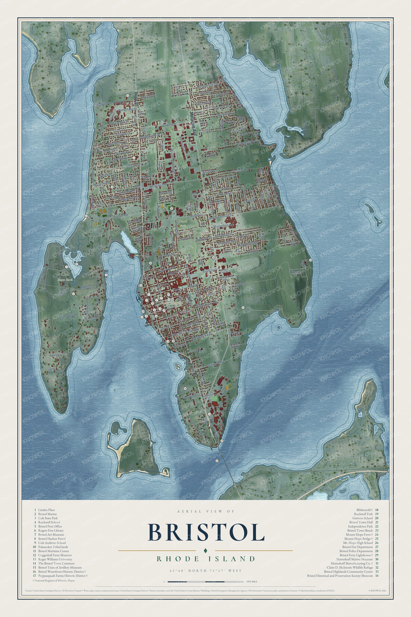
Explore Bristol, Rhode Island from a whole new perspective. Created using aerial imagery and detailed geographic data, this map captures Bristol building by building, with labeled streets, familiar landmarks, and shaded topographical relief that highlights the natural contours of the landscape.
Combining modern data with the timeless character of a vintage atlas, this map is just as interesting up close as it is beautiful on the wall. Whether you grew up in Bristol, spent memorable years there, or call it home today, this unique map is a great way to celebrate a place that means something to you. Zoom in on the preview to look for your street, and then order a print to put your memories on the wall.
Three ways to hang it

Unframed archival matte, a black wood frame or a white wood frame.
Up close
Geography Worth Displaying
This map was created using accurate cartographic data and authoritative geographic sources, including the U.S. Geological Survey (USGS) and FEMA. The map brings together terrain, waterways, roads, and building detail. The majority of the streets are labeled, houses are accurately depicted, and the topography is derived from government sources. Combining local data with carefully composed color and shading leads to this beautifully detailed Bristol artwork for your wall.
Rather than simply showing street outlines, we’ve included as many of the street names as we could reasonably fit on the map while keeping their names legible. Zoom in on the high resolution preview to see exactly what’s on the map. We truly set out to create a statement piece for anyone who loves Bristol. So whether it’s for you, or a gift for someone you love, we hope this map of Bristol brings back fond memories.
Explore the full map of Bristol, Rhode Island and read about the local places it shows.

Find your street
Names on the Bristol map
Every name below is printed on this map. Look for your street, your school, the park where you played, or the pond down the road.
Places and landmarks5
- Bristol Town Hall
- Colt State Park
- Paull Park
- Bristol Highlands
- Bristol Township
Streets and roads197
- Ferry Road
- Metacom Avenue
- Hope Street
- Tower Street
- Colt Drive
- Asylum Road
- Poppasquash Road
- Wood Street
- High Street
- Hopeworth Avenue
- State Street
- Franklin Street
- Annawamscutt Drive
- Broadcommon Road
- Narrows Road
- Chestnut Street
- Kickemuit Avenue
- Bayview Avenue
- Griswold Avenue
- Clam Shell Road
- Gooding Avenue
- Tupelo Street
- Fales Road
- Roosevelt Drive
- Dewolf Avenue
- Sherman Avenue
- Mount Hope Avenue
- Beach Road
- Gibson Road
- Sherry Avenue
Show all 197 streets
- Mulberry Road
- Aaron Avenue
- Ballou Boulevard
- Woodlawn Avenue
- Fatima Drive
- Michael Drive
- River Street
- King Philip Avenue
- Franca Drive
- Lisa Lane
- Greylock Road
- Sullivan Lane
- Leahy Drive
- Sowams Drive
- Mackenzie Avenue
- Naomi Street
- Butterworth Avenue
- Brooks Farm Drive
- Patricia Ann Drive
- Kingswood Road
- Berry Lane
- Smith Street
- Shore Road
- Addy Drive
- Buttonwood Street
- Perry Street
- Suprise Hill
- North Lane
- North Farm Drive
- Surf Drive
- Reliance Drive
- Charles Street
- Clubhouse Lane
- Viking Drive
- Everett Street
- Sefton Drive
- Lafayette Drive
- Academy Avenue
- Fernwood Road
- Roma Street
- Charlotte Drive
- Colt State Pk
- San Jose Drive
- Union Street
- Jennifer Drive
- Varnum Avenue
- Antony Avenue
- Oliver Street
- Burton Street
- Dixon Avenue
- Betsy Drive
- Terrace Drive
- Sandra Drive
- Juniper Court
- Fesser Avenue
- Collins Street
- Highview Drive
- Lugent Lane
- Walley Street
- Forest Road
- Wall Street
- Evelyn Drive
- Platt Street
- Jessica Drive
- Sousa Street
- Center Street
- Low Lane
- Valley Drive
- Paull Street
- Greg Drive
- Third Street
- Vantage Point Drive
- Old Ferry Road
- Coggeshall Farm Road
- Peck Avenue
- Tobin Lane
- Dolly Drive
- Constitution Street
- Fox Hill Avenue
- Beachmount Avenue
- Monroe Avenue
- Casey Drive
- Pokanoket Place
- Hamlet Court
- Jane Lane
- Courageous Circle
- Primrose Road
- Robin Drive
- Sea Breeze Lane
- Hydraulion Avenue
- Van Wickle Lane
- Sandy Lane
- Catherine Street
- Peter Road
- Ursula Drive
- Dimond Avenue
- Acacia Road
- Andrews Court
- Brookwood Road
- Massasoit Avenue
- Stephen Drive
- Wendy Drive
- Columban Drive
- Alan Drive
- Plant Avenue
- Loring Road
- East Low Lane
- Verndale Circle
- Wales Drive
- Shaws Lane
- Church Cove Road
- First Street
- George Street
- Paine Avenue
- Tina Court
- Usher Terrace
- Rego Avenue
- Thames Street
- Peckham Place
- Cliff Drive
- Wapping Drive
- Tilbury Drive
- Sweeney Lane
- Leila Jean Drive
- Portside Road
- Clipper Way
- Lea Drive
- Colonial Road
- Vernon Avenue
- Jenny Lane
- Judy Drive
- Etelvina Court
- Bourne Street
- Doran Avenue
- Minturn Farm Road
- Justin Street
- Herzig Street
- Wilcox Street
- Malden Street
- Babbitt Avenue
- Gray Street
- Carr Lane
- Monkey Wrench Lane
- Harrison Street
- Church Street
- Ridge Road
- Roger Williams Road
- Basswood Drive
- Richmond Street
- Sunset Road
- Weetamoe Farm Drive
- Sachem Road
- Manchester Street
- Kathy Court
- Defiance Avenue
- Wayland Road
- Baker Street
- Creek Lane
- Burke Road
- Alves Street
- Echo Farm Drive
- Slocum Street
- Ellen Street
- South Lane
- Proto Lane
- Amy Drive
- Jel Way
Names are listed as they appear on the printed map. Zoom into the product photos to find them.
About Bristol, Rhode Island
Bristol is a town of 22,493 people and the county seat of Bristol County, on a peninsula between Narragansett Bay and Mount Hope Bay. The land belonged to the Pokanokets, and Metacomet, whom the English called King Philip, used Mount Hope as his base in King Philip's War. The hill's name comes from the Pokanoket word Montaup. The war ended for Metacomet when Captain Benjamin Church ambushed him and he died on August 12, 1676.
After the war, four Boston merchants bought Mount Hope Neck and Poppasquash Neck: John Walley, Nathaniel Oliver, Nathaniel Byfield and Stephen Burton. In 1680 their new town was laid out around a common as part of Plymouth Colony, and it was named for Bristol, England. Bristol stayed a Massachusetts town until 1747, when the Crown moved it to Rhode Island, and it served as one of the state's five capitals until 1854.
“This being the first anniversary of the Declaration of Independence of the Rebel Colonies, they ushered in the morning by firing 13 cannons, one for each colony, we suppose. At sunset, the rebel frigates fired another round of 13 guns, each one after the other. As the evening was very still and fine the echo of the guns down the Bay had a grand effect.”
- Shelled in 1775, burned in 1778On October 7, 1775, Captain Wallace brought HMS Rose and other ships into the harbor and demanded supplies. The town refused, so his guns pounded it until Lieutenant Governor William Bradford rowed out to the Rose and talked the British into a cease-fire. That peace did not last. On May 25, 1778, 500 British and Hessian troops came up the main street, now Hope Street, burned 30 barracks and houses and took prisoners to Newport.
- The Fourth since 1785The Reverend Henry Wight, a Revolutionary War veteran and pastor of the First Congregational Church, started Bristol's Patriotic Exercises in 1785, and the town has held them every year since. Today the celebration begins on June 14, Flag Day, with concerts, a firefighters' muster and soapbox races, and its last day, July 4, brings the Military, Civic and Firemen's Parade. Over 200,000 people come to watch, and the crowds earned Bristol the name "America's most patriotic town."
- Eight America's Cup defendersFrom 1878 to 1945 the Herreshoff Manufacturing Company built sailing yachts here, and eight of them defended the America's Cup, including five in a row between 1893 and 1920. Boatbuilding is still one of Bristol's major industries, the harbor holds over 800 moorings, and the Herreshoff Marine Museum keeps more than sixty boats where the company's shops once stood.
- Private Property, Public WelcomeSamuel P. Colt, founder of the United States Rubber Company and nephew of the famous gunmaker, began buying the Chase, Church and Van Wickle farms on Poppasquash Neck in 1905 to raise prize Jersey cattle. Colt's will kept the farm open after his 1921 death.
- A light for the ferryIn 1855 the Bristol Ferry Lighthouse, a square tower of brick with a brick house for its keeper, went up at Bristol Point to guide the ferry to Aquidneck Island. Work on the Mount Hope Bridge put it out of service in 1927, and the bridge opened on October 24, 1929, with a main span of 1,200 feet. The lighthouse joined the National Register in 1988.
Keep exploring Rhode Island
Bristol is one of 86 Rhode Island towns we've mapped. Every dot on the map is a print of its own.
The search covers every state, Rhode Island first.
Near Bristol
Order 2 or more town maps and save 10%. Shown in the size and finish you picked above, so they hang as a set.
- Warren 12" x 18" / Archival Matte Print $39.99
- Barrington 12" x 18" / Archival Matte Print $39.99
- Nayatt 12" x 18" / Archival Matte Print $39.99


More maps nearby: Hampden Meadows, Portsmouth, Tiverton, Warwick and Melville.
The art of mapping a place
How This Map Was Made
Real places. Remarkable detail. Discover the layers that turn geographic data into a map of home.

The view from above
Aerial imagery reveals the character of the land: woodland, open fields, and the patterns of a place.

The shape of the land
Elevation data brings hills, valleys, and subtle changes in the landscape into view.

The details of home
Roads, waterways, and building footprints come together to make the map feel unmistakably local.

Geography becomes art
Considered color, shading, and typography bring the layers together in a map made for your wall.


Process illustrated with Mendon, Massachusetts. Aerial imagery: USDA NAIP. Terrain: USGS 3D Elevation Program. Map details and finished artwork: KNOWOL.
The Details
About This Print
Choose an archival matte print, or a black or white Ayous wood frame. The archival matte print is unframed.
Select your size and finish above to see the matching product image and price.
Materials & Craftsmanship
A contemporary map with the character of a classic atlas, printed on archival matte paper. Optional frames are made from Ayous wood.
Your printed map does not include the watermark shown in the full-map preview.
Shipping & Delivery
Free shipping within the United States. Every print is made to order in the USA.
Buying a gift? Add a note in your cart and we'll include it. We never put prices in the package.
Prints ship within 2 to 3 business days. Allow 7 to 10 days total from ordering for delivery. Timing may vary during holidays or periods of high order volume.
Read our shipping policy.
Returns and damaged prints
Each print is made to order. Change-of-mind refunds are not available after production.
If your print arrives damaged, misprinted or incorrect, contact support@knowol.com within 30 days of receiving it. Include your order number, photos and a description of the issue.
Read our full refund and replacement policy. For questions about your order, email support@knowol.com.