


Search for another town


Free U.S. delivery 7 to 10 days after you order
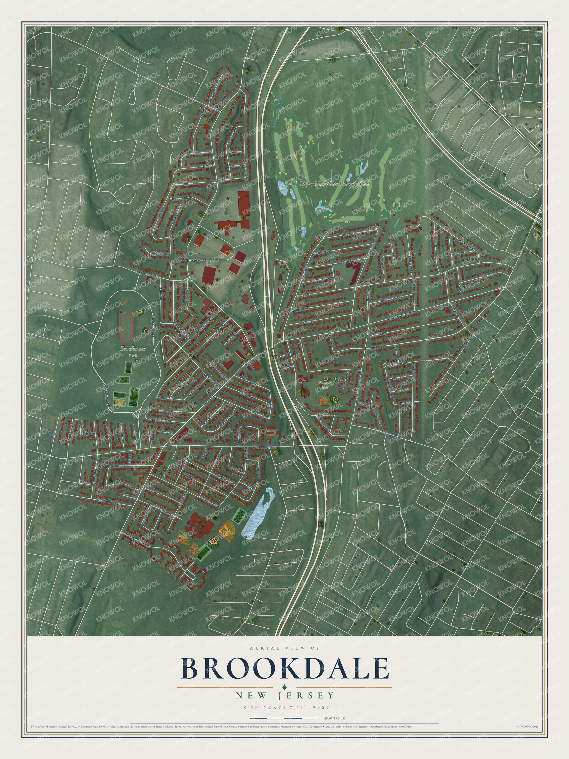
Brookdale, New Jersey Map Art
Building by building, with labeled streets and shaded relief.
12" x 18" Archival Matte Print
A Map of Home. A Work of Art.
Explore Brookdale, New Jersey from a whole new perspective. Created using aerial imagery and detailed geographic data, this map captures Brookdale building by building, with labeled streets, familiar landmarks, and shaded topographical relief that highlights the natural contours of the landscape.
Combining modern data with the timeless character of a vintage atlas, this map is just as interesting up close as it is beautiful on the wall. Whether you grew up in Brookdale, spent memorable years there, or call it home today, this unique map is a great way to celebrate a place that means something to you. Zoom in on the preview to look for your street, and then order a print to put your memories on the wall.
Three ways to hang it

Unframed archival matte, a black wood frame or a white wood frame.
Up close
Geography Worth Displaying
This map was created using accurate cartographic data and authoritative geographic sources, including the U.S. Geological Survey (USGS) and FEMA. The map brings together terrain, waterways, roads, and building detail. The majority of the streets are labeled, houses are accurately depicted, and the topography is derived from government sources. Combining local data with carefully composed color and shading leads to this beautifully detailed Brookdale artwork for your wall.
Rather than simply showing street outlines, we’ve included as many of the street names as we could reasonably fit on the map while keeping their names legible. Zoom in on the high resolution preview to see exactly what’s on the map. We truly set out to create a statement piece for anyone who loves Brookdale. So whether it’s for you, or a gift for someone you love, we hope this map of Brookdale brings back fond memories.
Explore the full map of Brookdale, New Jersey and read about the local places it shows.

Find your street
Names on the Brookdale map
Every name below is printed on this map. Look for your street, your school, the park where you played, or the pond down the road.
Places and landmarks3
- Brookdale Park
- Vassar Field
- Upper Montclair Country Club
Streets and roads119
- West Circuit Drive
- Brookdale Gdns
- Darling Avenue
- Broad Street
- West Passaic Avenue
- Watchung Avenue
- Sylvan Road
- East Circuit Drive
- Byrd Avenue
- East Passaic Avenue
- Lindbergh Boulevard
- Garrabrant Avenue
- Overlook Terrace
- Parkview Drive
- Evans Road
- Broadacres Drive
- Merkel Drive
- Ferncliff Road
- Day Street
- Golf Road
- Bellevue Terrace
- Hawthorne Avenue
- Bryant Avenue
- Mountain Avenue
- Farmingdale Avenue
- Johnson Avenue
- Renner Avenue
- Beverly Road
- High Street
- Reigate Road
Show all 119 streets
- Clair Street
- Ernst Avenue
- Claremont Avenue
- Collins Avenue
- Bellevue Avenue
- Coeyman Avenue
- Winding Lane
- Ivanhoe Terrace
- Whittle Avenue
- Garner Avenue
- Meadow Lane
- Eaton Place
- Hyde Road
- Dalebrook Road
- George Street
- Yantecaw Avenue
- Davis Avenue
- Bell Street
- Raab Avenue
- North Avenue
- Mohr Avenue
- Craig Place
- Morley Lane
- Leo Terrace
- Jacob Street
- Huck Road
- North End Terrace
- Haines Drive
- Elmbrook Place
- Carol Place
- Clubb Street
- Fairway Street
- Urma Place
- Red Maple Avenue
- Oakridge Road
- Skyview Road
- Perry Road
- Highfield Road
- Newell Drive
- Este Place
- Donna Drive
- Barnett Street
- Macleod Lane
- Albert Terrace
- Kinder Drive
- Clover Lane
- Highview Terrace
- Glenfield Road
- Aldon Terrace
- Alyson Place
- Lowell Terrace
- Demarest Avenue
- Bolten Place
- Yale Street
- Emerson Terrace
- Brookdale Road
- Foster Street
- Pieretti Court
- Wells Court
- Elizabeth Court
- Whittier Terrace
- Rutgers Place
- Wilber Terrace
- Irwin Place
- Rutan Place
- Rossen Place
- Doris Place
- Barnes Place
- Byrd Place
- Reid Avenue
- Hearthstone Road
- Phillips Street
- School Street
- Duane Place
- Andover Place
- Chestnut Terrace
- Meisler Road
- Whitman Street
- Davidson Road
- Twain Street
- Wagner Street
- Parsons Court
- Poe Avenue
- Holly Court
- Alexander Avenue
- Williams Street
- Ridgewood Avenue
- Burnett Street
- Boulder Place
Names are listed as they appear on the printed map. Zoom into the product photos to find them.
About Brookdale, New Jersey
Brookdale is a community of 9,854 people in Bloomfield Township, Essex County, covering roughly the section of Bloomfield that lies north of Bay Avenue. Its first English name was Stone House Plains. The stone house was a great rock, said to have once been large enough to take shelter in, standing just north of today's corner of Bellevue Avenue and Newell Drive. It still stood in 1802 but was hauled away soon after, and the plains were the flats along the Yantacaw River.
Early in the 18th century, families began settling along Bellevue Avenue, and Abraham Van Giesen may have been among them. By about 1750 two brothers from Bergen, Garrabrant and Teunis Garrabrant, owned large pieces of land near what is now Brookdale Park. The Sigler and Coeyman households were early farmers too, and Dutch stayed the daily speech of many homes through the 18th century. The first school opened in the mid-1800s, and in 1873, as mail delivery was about to start, residents voted to take the name Brookdale.
- A Dutch church since 1795In 1795 the community organized the Dutch Reformed Church of Stone House Plains, which became the heart of local religious and social life. Its first building went up in 1802, and after it burned, the congregation rebuilt about 1857. The church carries on today as Brookdale Reformed Church.
- The Cockefair plantationAround 1730 Alexander Cockefair, born about 1696 in Bushwick, bought a plantation stretching roughly between the Yantacaw Brook, Broad Street and Watchung Avenue. His descendants, like those of the other early families, kept farms, mills and businesses going here for more than two centuries. After World War I most of Brookdale's farmland turned into housing. Part of the old Cockefair land became a golf course, and another part became the site of a junior high school, now Bloomfield Middle School.
- From mill pond to Clark's PondThe Morris family, millers whose works stood a little south of Brookdale, dammed the Yantacaw Brook to make a mill pond. The Clark Thread Company later bought it and put up a factory beside it for coloring thread, a building the Scientific Glass Company used afterward. The water is still known as Clark's Pond.
- Brookdale Park, finished in 1937Lenape people once planted and gathered on this land, and longtime residents recall horse-drawn wagons dumping ash there from neighboring towns' furnaces. Essex County built the park to an Olmsted firm design, and most of it was ready by 1930, but the Great Depression slowed the work until 1937. Bloomfield shares it with Montclair, and its rose garden holds more than 100 species.
Keep exploring New Jersey
Brookdale is one of 990 New Jersey towns we've mapped. Every dot on the map is a print of its own.
The search covers every state, New Jersey first.
Near Brookdale
Order 2 or more town maps and save 10%. Shown in the size and finish you picked above, so they hang as a set.
- Upper Montclair 12" x 18" / Archival Matte Print $39.99
- Nutley 12" x 18" / Archival Matte Print $39.99
- Montclair 12" x 18" / Archival Matte Print $39.99

More maps nearby: Bloomfield, Clifton, Montclair State University, Glen Ridge and Great Notch.
The art of mapping a place
How This Map Was Made
Real places. Remarkable detail. Discover the layers that turn geographic data into a map of home.

The view from above
Aerial imagery reveals the character of the land: woodland, open fields, and the patterns of a place.

The shape of the land
Elevation data brings hills, valleys, and subtle changes in the landscape into view.

The details of home
Roads, waterways, and building footprints come together to make the map feel unmistakably local.

Geography becomes art
Considered color, shading, and typography bring the layers together in a map made for your wall.


Process illustrated with Mendon, Massachusetts. Aerial imagery: USDA NAIP. Terrain: USGS 3D Elevation Program. Map details and finished artwork: KNOWOL.
The Details
About This Print
Choose an archival matte print, or a black or white Ayous wood frame. The archival matte print is unframed.
Select your size and finish above to see the matching product image and price.
Materials & Craftsmanship
A contemporary map with the character of a classic atlas, printed on archival matte paper. Optional frames are made from Ayous wood.
Your printed map does not include the watermark shown in the full-map preview.
Shipping & Delivery
Free shipping within the United States. Every print is made to order in the USA.
Buying a gift? Add a note in your cart and we'll include it. We never put prices in the package.
Prints ship within 2 to 3 business days. Allow 7 to 10 days total from ordering for delivery. Timing may vary during holidays or periods of high order volume.
Read our shipping policy.
Returns and damaged prints
Each print is made to order. Change-of-mind refunds are not available after production.
If your print arrives damaged, misprinted or incorrect, contact support@knowol.com within 30 days of receiving it. Include your order number, photos and a description of the issue.
Read our full refund and replacement policy. For questions about your order, email support@knowol.com.