


Search for another town


Free U.S. delivery 7 to 10 days after you order
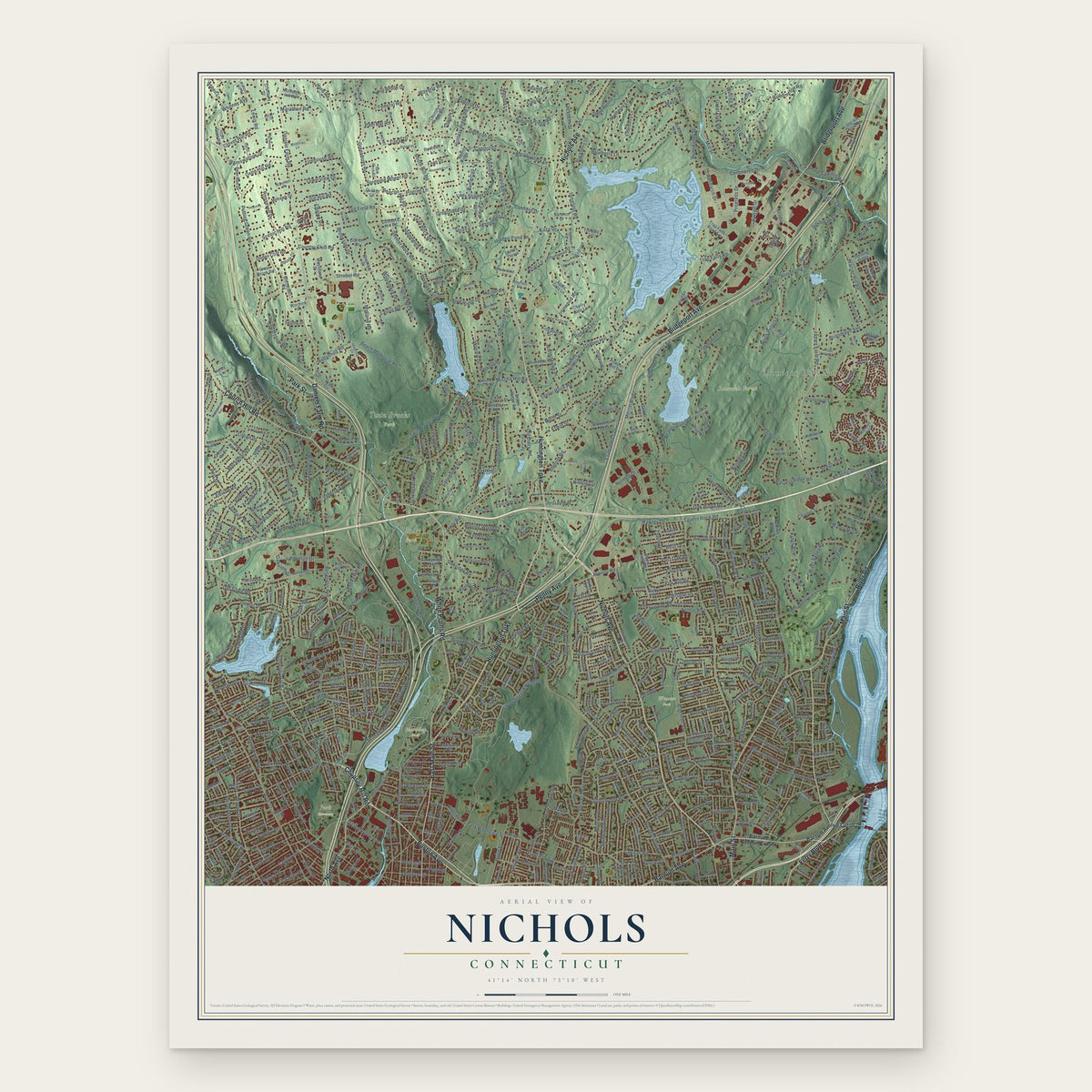
Nichols, Connecticut Map Art
Building by building, with labeled streets and shaded relief.
12" x 18" Archival Matte Print
A Map of Home. A Work of Art.
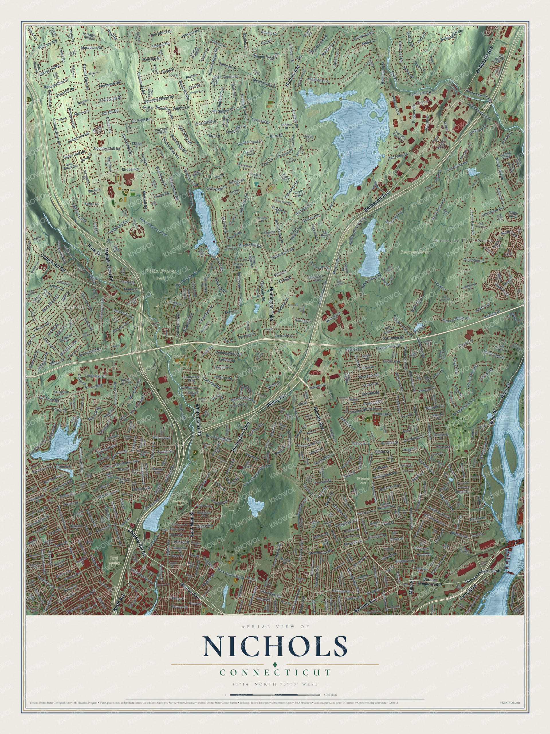
Explore Nichols, Connecticut from a whole new perspective. Created using aerial imagery and detailed geographic data, this map captures Nichols building by building, with labeled streets, familiar landmarks, and shaded topographical relief that highlights the natural contours of the landscape.
Combining modern data with the timeless character of a vintage atlas, this map is just as interesting up close as it is beautiful on the wall. Whether you grew up in Nichols, spent memorable years there, or call it home today, this unique map is a great way to celebrate a place that means something to you. Zoom in on the preview to look for your street, and then order a print to put your memories on the wall.
Three ways to hang it
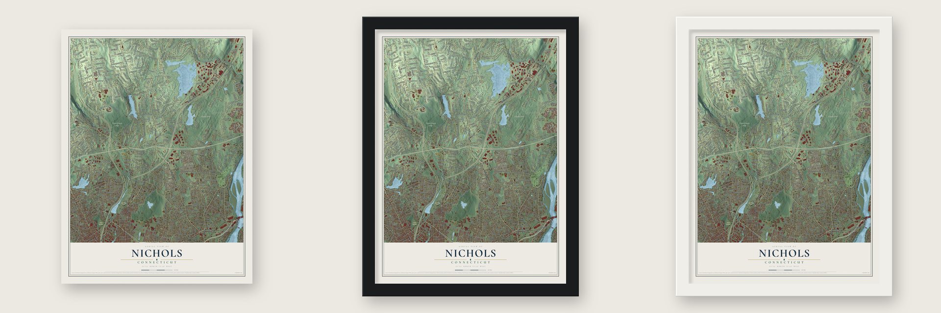
Unframed archival matte, a black wood frame or a white wood frame.
Up close
Geography Worth Displaying
This map was created using accurate cartographic data and authoritative geographic sources, including the U.S. Geological Survey and the Census Bureau. The map brings together terrain, waterways, roads, and building detail. The majority of the streets are labeled, houses are accurately depicted, and the topography is derived from government sources. Combining local data with carefully composed color and shading leads to this beautifully detailed Nichols artwork for your wall.
Rather than simply showing street outlines, we’ve included as many of the street names as we could reasonably fit on the map while keeping their names legible. Zoom in on the high resolution preview to see exactly what’s on the map. We truly set out to create a statement piece for anyone who loves Nichols. So whether it’s for you, or a gift for someone you love, we hope this map of Nichols brings back fond memories.
Read the story behind this map: Detailed Map of Nichols, Connecticut.

Find your street
Names on the Nichols map
Every name below is printed on this map. Look for your street, your school, the park where you played, or the pond down the road.
Places and landmarks8
- Trumbull
- Beardsley Park
- Park Cemetery
- Roosevelt Forest
- Twin Brooks Park
- Unity Park
- Wooster Park
- Oronoque Hills North
Streets and roads721
- Nichols Avenue
- Boston Avenue
- North Avenue
- Chopsey Hill Road
- Penny Avenue
- Huntington Turnpike
- East Main Street
- Bridgeport Avenue
- Main Street
- White Plains Road
- Barnum Avenue
- Church Hill Road
- Ferry Boulevard
- River Road
- Daniels Farm Road
- Park Street
- Booth Hill Road
- Silver Lane
- Lake Street
- Huntington Road
- Sylvan Avenue
- King Street
- Old Town Road
- Buddington Road
- Shelton Road
- Beacon Hill Road
- Mill Street
- Peters Lane
- Pitt Street
- Broadbridge Avenue
Show all 721 streets
- Reservoir Avenue
- Isinglass Road
- Huntington Street
- Evers Street Extended
- James Farm Road
- Cutspring Road
- Strobel Road
- Hilltop Drive
- Beaver Dam Road
- Noble Avenue
- Success Avenue
- Putting Green Road
- Blueberry Lane
- Second Hill Lane
- Lindley Street
- Merritt Boulevard
- Wayne Street
- Whippoorwill Lane
- Freeman Avenue
- Commerce Drive
- Chapel Street
- Twin Brooks Drive
- Unity Road
- Platt Street
- Capitol Avenue
- Pearl Harbor Street
- South Trail
- North Trail
- Waverly Road
- Lakeside Drive
- Armstrong Road
- Hawley Lane
- Whitney Avenue
- Edison Road
- Palisade Avenue
- Cali Drive
- Old Field Road
- Seltsam Road
- Trumbull Avenue
- Beardsley Parkway
- Capitol Drive
- Wigwam Lane
- Broadbridge Road
- Connors Lane
- Warner Hill Road
- Pond Street
- Berkshire Avenue
- Madison Avenue
- Old Stratford Road
- Beach Memorial Road
- Canaan Road
- William Street
- Roosevelt Drive
- Saint John's Drive
- Macarthur Road
- Greenfield Drive
- Oronoque Lane
- Greenbrier Road
- Woolsley Avenue
- Columbine Drive
- Oakridge Road
- Amsterdam Avenue
- Patricia Drive
- Light Street
- Arden Road
- Ironwood Road
- Beechmont Avenue
- Robin Lane
- Brinsmayd Avenue
- Stonybrook Road
- Lincoln Avenue
- Evers Street
- Bridgeview Place
- Asylum Street
- Twitchgrass Road
- Soundview Avenue
- Lawrence Road
- North Street
- Anson Street
- Patterson Avenue
- Golden Hill
- Gurdon Street
- Wilcoxson Avenue
- Deerfield Drive
- Hawley Avenue
- Greenfield Avenue
- Jennings Avenue
- Teeter Rock Road
- Mulberry Lane
- Leonard Place
- California Street
- Allyndale Drive
- Harvest Ridge Road
- Highland Avenue
- Quarry Road
- Granfield Avenue
- Stoneleigh Road
- Douglas Street
- River Valley Road
- Horace Street
- Bond Street
- Gray Rock Road
- Great Oak Road
- Putnam Street
- Old Hollow Road
- Shelter Rock Road
- Bunnyview Drive
- Salem Street
- Lawlor Terrace
- Research Drive
- Hollywood Avenue
- Summit Street
- Indian Avenue
- Midland Road
- Brookside Drive
- Kenyon Street
- Barnswallow Drive
- Jog Hill Road
- Hidden Pond Lane
- North Stowe Place
- Tavern Rock Road
- Lady Slipper Drive
- Spring Street
- Overland Drive
- Booth Street
- Scenic Hill Road
- Hillside Avenue
- Priscilla Street
- Rolling Brook Lane
- September Lane
- Spinning Wheel Road
- Wakelee Avenue
- North Peters Lane
- Hooker Road
- Woodrow Avenue
- Oakwood Street
- Lincoln Street
- Savoy Street
- Rocky Hill Road
- Valley View Road
- Hillcrest Road
- Beard Sawmill Road
- Daybreak Lane
- Oceanview Terrace
- Thorme Street
- Housatonic Drive
- Exeter Street
- Great Neck Road
- Tait Road
- Williams Road
- Emerald Place
- Progress Drive
- Mary Avenue
- Lewis Road
- Wesley Drive
- Armory Road
- Holland Road
- Marina Drive
- Skyview Drive
- Maple Lane
- Wilson Avenue
- Hurd Road
- Swanson Avenue
- Charles Street
- Polk Street
- Griffin Avenue
- Henry Avenue
- Elizabeth Street
- Hedgehog Road
- Coral Drive
- Reed Street
- Towerview Drive
- Hart Street
- Parkway Drive
- Firehouse Road
- Shawnee Road
- River Street
- Friar Lane
- Carol Road
- Federal Street
- Nutmeg Lane
- Tower Lane
- French Street
- Federal Road
- Country Club Road
- Fern Circle
- Judson Street
- Lindeman Drive
- Hunters Ridge Road
- Wells Street
- Lillian Drive
- Trap Falls Road
- Johnson Lane
- West Lake Road
- Hurd Avenue
- Meadowlark Drive
- Luanne Road
- Woodmere Drive
- Keating Drive
- Burbank Avenue
- Fairfax Drive
- Plymouth Street
- Canfield Drive
- Castle Drive
- Rolling Wood Drive
- Cathy Drive
- Kazo Drive
- Pearl Street
- Valley Avenue
- Alpine Street
- Cedar Knoll Drive
- Euclid Avenue
- Dexter Drive
- Wilbrook Road
- Judith Terrace
- Twin Brook Drive
- Wisteria Drive
- Funston Avenue
- Ashwood Terrace
- Circle Drive
- Red Oak Road
- Marathon Road
- Island Brook Avenue
- Birmingham Street
- Oak Ridge Road
- Oxen Hill Road
- North Bishop Avenue
- Sunnycrest Road
- Post Oak Road
- Leffert Road
- Autumn Ridge Road
- Laurie Road
- Albright Avenue
- Johnson Avenue
- Hillston Road
- Reitter Street
- Reeds Lane
- Erwin Street
- Fox Hill Road
- Norland Avenue
- Raven Terrace
- Quail Street
- Lynne Place
- Woodstock Avenue
- Dahl Avenue
- Park Boundary Street
- Moorland Road
- Stone House Road
- Under Cliff Road
- Fiske Avenue
- Weber Avenue
- Craig Lane
- Hemlock Trail
- Bronx Avenue
- Texas Avenue
- Adams Drive
- Ruth Street
- Clover Hill Road
- Parrott Drive
- Old Green Road
- Red Fox Lane
- Old Dairy Road
- Chalon Road
- Marcroft Street
- Arrowhead Place
- Courtland Road
- Inca Drive
- Pilgrim Road
- Oakview Drive
- Nichols Terrace
- Flagler Avenue
- Arlington Street
- Hilltop Circle
- Buttercup Lane
- Yaremich Drive
- Mischa Hill Road
- Diane Terrace
- Matilda Lane
- Avalon Gates
- Elberta Avenue
- Pert Street
- Manor Drive
- Clover Street
- Hinman Street
- Blue Ridge Drive
- Kings Row
- Hickory Street
- Laurel Street
- Wood Avenue
- Zenith Drive
- Manor Hill Road
- Rutlee Drive
- Edna Avenue
- Darrin Drive
- Andrew Drive
- Forest Road
- Topaz Place
- Sylvan Street
- Pilgrim Lane
- Val Drive
- Reut Drive
- Pam Bar Road
- Fern Drive
- Terry Place
- Rose Street
- Stella Street
- Daniel Drive
- Nutmeg Drive
- Bailey Street
- Deborah Drive
- Edwards Street
- Auburn Street
- Aspen Lane
- Beers Place
- Reiner Drive
- Sultan Street
- Grace Lane
- Tory Lane
- Euerle Street
- Ross Drive
- Hale Terrace
- Arbor Street
- Fern Street
- Peck Street
- April Lane
- Barnum Avenue Cutoff
- Silver Street
- Glenwood Avenue
- Village Lane
- Beaver Dam Access Road
- Mc Nair Street
- Frenchtown Road
- Old Dike Road
- Bayberry Lane
- Woodcrest Avenue
- River Bend Road
- Long Hill Cross Road
- Dogwood Drive
- Rolling Ridge Road
- Longbrook Avenue
- Housatonic Avenue
- Franklin Avenue
- Maple Oak Drive
- Woodlawn Avenue
- Primrose Drive
- Country Ridge Drive
- Old Sawmill Road
- Pleasantview Avenue
- Wilbar Drive
- Alba Avenue
- Seabreeze Drive
- Mount Pleasant Avenue
- Ezra Street
- Dover Street
- Avalon Drive
- Harlem Avenue
- Chamberlain Avenue
- Partridge Lane
- Round Hill Road
- Oriole Lane
- Wildwood Drive
- Norwood Terrace
- Woodside Avenue
- Harmony Street
- Pumpkin Ground Road
- Trap Falls Road Extension
- High View Drive
- Briarwoods Terrace
- Glenn Drive
- Cannon Drive
- Elderberry Lane
- Kingsbury Drive
- Turkey Meadow Road
- Jerome Avenue
- Gibson Avenue
- Iron Gate Road
- Butternut Lane
- Dogwood Lane
- Cherry Gate Lane
- Rocky Hill Terrace
- Porter Street
- Brookbend Drive
- Linley Road
- Robinwood Road
- Nemergut Drive
- Garnet Road
- Franklin Street
- Deer Run Drive
- Delaware Drive
- Horseshoe Drive
- Elaine Street
- Tanglewood Road
- Ridge Road
- Green Ridge Road
- Sampson Street
- Sunshine Circle
- Apple Gate Lane
- Cottage Place
- Louisiana Avenue
- Summer Street
- Coggswell Street
- Rocton Avenue
- Chatham Drive
- Finchwood Drive
- Blackberry Lane
- Broadmere Road
- Bonnie Brook Drive
- Macdonald Road
- Jerusalem Hl
- Virginia Avenue
- Karen Avenue
- Cricket Lane
- Legion Avenue
- Glenfield Avenue
- Larkspur Drive
- Charlton Street
- Lobdell Drive
- Rouleau Lane
- Abram Street
- Glenbrook Road
- Unity Drive
- Mohawk Drive
- Goldenrod Avenue
- Birdsey Street
- Cityview Avenue
- Sun Ridge Lane
- Magnolia Street
- Beacon Street
- Thornberg Street
- Salem Road
- Quaker Lane
- Glenwood Drive
- Lakeview Avenue
- Wiebe Avenue
- Cobblers Hill Road
- Bittersweet Lane
- Bulldog Boulevard
- Ann Terrace
- Lindberg Drive
- Frog Pond Lane
- Nautilus Road
- Coppel Lane
- Old Coach Lane
- Pachaug Road
- Matthew Drive
- Merriam Street
- Glenarden Road
- Hunting Street
- Sterling Ridge
- Mayflower Drive
- Ruby Lane
- Sunnyridge Parkway
- Clarion Place
- Manila Street
- Kathryn Drive
- Cranbury Drive
- Karen Court
- Wildrose Lane
- Nuthatch Hill Road
- Flora Drive
- Brenair Terrace
- Elizabeth Terrace
- Salvia Street
- Saranor Drive
- Quail Trail
- Fairfax Road
- Powder Mill Lane
- Pine Point Drive
- Bretton Street
- Bartlett Lane
- Stones Throw
- Post Street
- Ash Circle
- Skytop Drive
- Great Brook Road
- Yukon Street
- Timothy Lane
- Hawley Road
- Balsam Avenue
- Spruce Drive
- Bison Lane
- Squire Court
- Oman Place
- Acadia Lane
- Sulik Terrace
- Oakleaf Street
- Gina Circle
- Beverly Road
- Stewart Street
- Eaton Street
- Locust Street
- Hunter Lane
- Kent Street
- Lawn Street
- Plane Tree Road
- Wordins Lane
- Winton Place
- Regent Terrace
- Daniels Avenue
- Mercer Street
- Derby Place
- Drew Circle
- Nyack Lane
- Willard Road
- York Street
- Hardy Lane
- Van Street
- Toni Place
- Bridle Trail
- Leo Lane
- Cove Point
- Prim Street
- Erie Lane
- Hill Circle
- Highwood Place
- Cardinal Circle
- Juniper Ridge Road
- Rosebrook Drive
- Lounsbury Road
- West Mischa Road
- Houston Avenue
- Puritan Road
- Tremont Avenue
- Quarry Street
- Elliott Street
- Briarfield Drive
- Livingston Place
- Okenuck Trail
- Voight Avenue
- Kenwood Avenue
- Fairchild Road
- Moffitt Street
- Wessels Avenue
- Porters Hill Road
- Carriage Drive
- Del Drive
- Candlewood Road
- Robin Street
- Smoke Valley
- Sheffield Drive
- Blueberry Road
- Heartwood Lane
- College Street
- Fairoaks Drive
- Cambridge Drive
- Eureka Avenue
- Midwood Trail
- Bunnell Avenue
- Melville Street
- Oriole Court
- Pasadena Avenue
- Bear Den Road
- Shadowood Lane
- Terrill Road
- Pequonnock Road
- Piute Lane
- Wildfire Lane
- Split Rock Road
- Wilcox Street
- Merritt Street
- Perry Lane
- Isinglass Terrace
- Valley Road
- Woodlawn Terrace
- Brandon Avenue
- Wyoming Street
- Newton Street
- Boston Terrace
- Linda Lane
- Dawn Drive
- Twin Circle Drive
- Alvord Street
- Colony Street
- Emerson Drive
- Mill Pond Road
- Canary Place
- Wareham Place
- Morning Dew Lane
- Linton Street
- Stock Street
- Warwick Avenue
- Oakdale Street
- Arthurs Court
- Lilibeth Drive
- Rustown Drive
- Colonial Avenue
- Maggie Lane
- Essex Street
- Aldo Drive
- Canyon Drive
- Masna Place
- Canaan Court
- Hill Street
- Crown Street
- Rita Avenue
- Opa Lane
- Valley Circle
- Trojan Drive
- Alice Terrace
- Platt Place
- Essex Place
- Saint Johns Drive
- Garfield Avenue
- Westfield Avenue
- Rocky Ridge Drive
- Wiklund Avenue
- Barnum Terrace Extended
- High Ridge Drive
- Doe Hollow Drive
- Marion Street
- Orchard Street
- Copper Kettle Road
- Middlebrooks Avenue
- Tesiny Avenue
- Poplar Street
- Evergreen Lane
- Barnum Terrace
- Sunset Avenue
- Grandview Drive
- Rosewood Lane
- Ortega Avenue
- Hedgehog Circle
- Hillandale Terrace
- Cemetery Drive
- Russell Road
- Bulmer Drive
- Sidney Street
- Rosewood Place
- Rexview Circle
- Lansing Avenue
- Cupheag Crescent
- Rennison Road
- Heavenly Lane
- Washington Street
- Quinnipiac Lane
- Sorel Drive
- Hawks Ridge Drive
- White Birch Drive
- North Pasture Lane
- Chase Street
- Haylot Road
- Claudia Drive
- Old Town Drive
- Harvest Hill Drive
- Willow Avenue
- Putney Chapel Way
- Corporate Drive
- Ulrich Road
- Monroe Street
- Forestview Road
- Englewood Avenue
- Oxford Drive
- Tully Circle
- Saybrook Road
- Vine Street
- Roosevelt Street
- Catherine Street
- Creston Road
- Priscilla Place
- Trout Creek Road
- Fox Wood Road
- White Oak Road
- Charron Street
- Roosevelt Forest Drive
- Barrows Street
- Maefair Court
- Ripton Parish
- Sweetbriar Road
- Disbrow Street
- Sorghum Terrace
- Woodhill Road
- Walker Drive
- Kingsbury Road
- Old Stream Lane
- Valley Brook Road
- Clements Drive
- Fawn Circle
- Veterans Boulevard
- Stone Ridge Road
- Peacock Drive
- Village Drive
- Tanager Place
- Bonazzo Drive
- Pauline Street
- Weaver Drive
- Renzy Avenue
- Brock Street
- Pearl Place
- Zoar Street
- Motil Place
- Hyde Terrace
Names are listed as they appear on the printed map. Zoom into the product photos to find them.
About Nichols, Connecticut
The village is named for the Nichols family. They ran a big farm in the middle of it for nearly three centuries. In May 1725 Stratford farmers here petitioned to form a parish called Nichol's Farms. Lawmakers approved it that October but gave it the name Unity.
Igor Sikorsky, the aviation pioneer, made his home in Nichols from 1928 to 1951. He lived in three houses there. During those years he designed and flew airplanes. He also became the first to mass produce the helicopter.
Keep exploring Connecticut
Nichols is one of 382 Connecticut towns we've mapped. Every dot on the map is a print of its own.
The search covers every state, Connecticut first.
Near Nichols
Order 2 or more town maps and save 10%. Shown in the size and finish you picked above, so they hang as a set.
- Trumbull Center 12" x 18" / Archival Matte Print $39.99
- Oronoque 12" x 18" / Archival Matte Print $39.99
- Stratford 12" x 18" / Archival Matte Print $39.99


More maps nearby: Stratford Downtown, Trumbull, Daniels Farm, Long Hill and Bridgeport.
The art of mapping a place
How This Map Was Made
Real places. Remarkable detail. Discover the layers that turn geographic data into a map of home.

The view from above
Aerial imagery reveals the character of the land: woodland, open fields, and the patterns of a place.

The shape of the land
Elevation data brings hills, valleys, and subtle changes in the landscape into view.

The details of home
Roads, waterways, and building footprints come together to make the map feel unmistakably local.

Geography becomes art
Considered color, shading, and typography bring the layers together in a map made for your wall.


Process illustrated with Mendon, Massachusetts. Aerial imagery: USDA NAIP. Terrain: USGS 3D Elevation Program. Map details and finished artwork: KNOWOL.
The Details
About This Print
Choose an archival matte print, or a black or white Ayous wood frame. The archival matte print is unframed.
Select your size and finish above to see the matching product image and price.
Materials & Craftsmanship
A contemporary map with the character of a classic atlas, printed on archival matte paper. Optional frames are made from Ayous wood.
Your printed map does not include the watermark shown in the full-map preview.
Shipping & Delivery
Free shipping within the United States. Every print is made to order in the USA.
Buying a gift? Add a note in your cart and we'll include it. We never put prices in the package.
Prints ship within 2 to 3 business days. Allow 7 to 10 days total from ordering for delivery. Timing may vary during holidays or periods of high order volume.
Read our shipping policy.
Returns and damaged prints
Each print is made to order. Change-of-mind refunds are not available after production.
If your print arrives damaged, misprinted or incorrect, contact support@knowol.com within 30 days of receiving it. Include your order number, photos and a description of the issue.
Read our full refund and replacement policy. For questions about your order, email support@knowol.com.