
Search for another town


Free U.S. delivery 7 to 10 days after you order
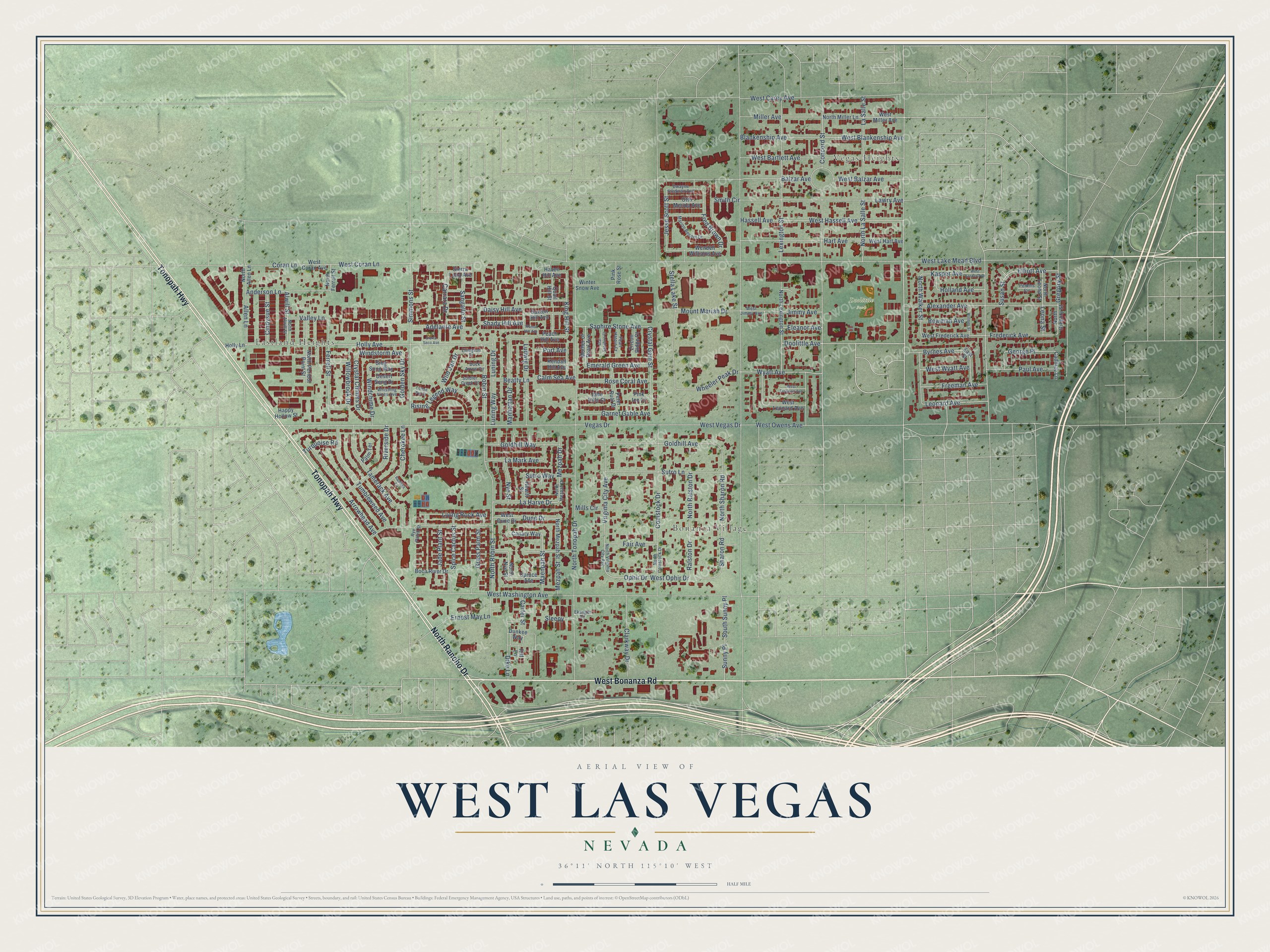
West Las Vegas, Nevada Map Art
Building by building, with labeled streets and shaded relief.
12" x 18" Archival Matte Print
A Map of Home. A Work of Art.
Explore West Las Vegas, Nevada from a whole new perspective. Created using aerial imagery and detailed geographic data, this map captures West Las Vegas building by building, with labeled streets, familiar landmarks, and shaded topographical relief that highlights the natural contours of the landscape.
Combining modern data with the timeless character of a vintage atlas, this map is just as interesting up close as it is beautiful on the wall. Whether you grew up in West Las Vegas, spent memorable years there, or call it home today, this unique map is a great way to celebrate a place that means something to you. Zoom in on the preview to look for your street, and then order a print to put your memories on the wall.
Three ways to hang it

Unframed archival matte, a black wood frame or a white wood frame.
Up close
Geography Worth Displaying
This map was created using accurate cartographic data and authoritative geographic sources, including the U.S. Geological Survey and the Census Bureau. The map brings together terrain, waterways, roads, and building detail. The majority of the streets are labeled, houses are accurately depicted, and the topography is derived from government sources. Combining local data with carefully composed color and shading leads to this beautifully detailed West Las Vegas artwork for your wall.
Rather than simply showing street outlines, we’ve included as many of the street names as we could reasonably fit on the map while keeping their names legible. Zoom in on the high resolution preview to see exactly what’s on the map. We truly set out to create a statement piece for anyone who loves West Las Vegas. So whether it’s for you, or a gift for someone you love, we hope this map of West Las Vegas brings back fond memories.
Read the story behind this map: Detailed Map of West Las Vegas, Nevada.

Find your street
Names on the West Las Vegas map
Every name below is printed on this map. Look for your street, your school, the park where you played, or the pond down the road.
Places and landmarks4
- Vegas Heights
- Eastland Heights
- Bonanza Village
- Doolittle Park
Streets and roads191
- West Bonanza Road
- Tonopah Highway
- North Rancho Drive
- Doolittle Avenue
- Robin Street
- North Robin Street
- La Harve Drive
- West Wyatt Avenue
- Holly Avenue
- Anderson Lane
- West Blankenship Avenue
- Wheeler Peak Drive
- Lawry Avenue
- West Owens Avenue
- North La Salle Street
- North Sharon Road
- King Hill Street
- Willowbrook Drive
- Shady Hill Avenue
- Beatty Lane
- Smith Circle
- Crystal Gem Street
- Nye Street
- Jimmy Avenue
- Windstorm Avenue
- West Lake Mead Boulevard
- Vegas Drive
- West Vegas Drive
- North Tonopah Drive
- West Washington Avenue
Show all 191 streets
- Comstock Drive
- Coran Lane
- Balzar Avenue
- Lexington Street
- West Carey Avenue
- La Salle Street
- Miller Avenue
- Blankenship Avenue
- West Bartlett Avenue
- Hassell Avenue
- West Hassell Avenue
- Hart Avenue
- Simmons Street
- West Balzar Avenue
- Alexander Avenue
- Goldhill Avenue
- Concord Street
- Ferrell Street
- Frederick Avenue
- Fair Avenue
- Wyatt Avenue
- Virginia City Avenue
- Sharon Road
- Stella Lake Street
- Tamerack Avenue
- Dune Drive
- Tumbleweed Avenue
- Sutro Lane
- Arrowhead Avenue
- Ophir Drive
- West Ophir Drive
- Leonard Avenue
- North Ralston Drive
- Ralston Drive
- Riverside Drive
- Rising Legend Way
- Freeman Avenue
- Luning Drive
- Luning Way
- Ludwig Drive
- Manhattan Drive
- South Sunny Place
- Sunny Place
- Grass Palm Street
- Clarkway Drive
- Spice Cactus Street
- West Coran Lane
- Allen Lane
- Mezpah Street
- Goldhill Way
- Gregory Street
- Rose Coral Avenue
- Saphire Stone Avenue
- Crystal Chimes Drive
- Cherokee Lane
- Paul Avenue
- George Place
- Garnet Gable Avenue
- Fred Brown Drive
- Living Rock Avenue
- Mount Mariah Drive
- Mezpah Drive
- Emerald Green Avenue
- Leona Street
- Sangallo Street
- Ernest May Lane
- Kasper Avenue
- Carrara Drive
- Adelante Avenue
- North Walker Street
- Jesse Scott Street
- Maenpah Street
- Windchime Drive
- Jade Plant Street
- La Mark Avenue
- Dike Lane
- Byrnes Avenue
- Mills Circle
- Cindysue Street
- Elliott Avenue
- Alwill Street
- Sutro Way
- Bowman Avenue
- Holland Avenue
- Golden Sky Drive
- Daisy Hill Avenue
- Calm Sea Avenue
- Wild Jan Drive
- Eleanor Avenue
- Turquoise Road
- Valley Lane
- Carter Street
- Port Avenue
- Susan Street
- Sleepy
- West Miller Avenue
- North Miller Lane
- North Ferrell Street
- North Lexington Street
- Peach Hill Avenue
- North Nye Street
- West Hart Avenue
- West Leonard Avenue
- North Allen Lane
- North Mezpah Street
- Boca River Drive
- West Dune Drive
- West Coran Avenue
- North Leona Street
- North Gregory Street
- West Frederick Avenue
- Peter Buol Drive
- Wendell Williams Avenue
- Saxton Hill Avenue
- North Peridot Point Street
- Mother of Pearl Avenue
- East Street
- Otto Merida Avenue
- Pink Rose Street
- Kendall Hill Avenue
- Jade Hills Court
- Spruce Avenue
- Canary Way
- Sing Song Way
- Desert Song Drive
- Dunkee Way
- Cadillac Lane
- Quail Hill Street
- Happy Hollow Street
- Winter Snow Avenue
- Zircon Ridge Court
- Hewitt Street
- Haven Hill Avenue
- Sierra Luna Avenue
- Palm Terrace
- Holly Lane
- Pink Ice Court
- Riff Lane
- Ellingson Drive
- North Mezpah Drive
- West Jimmy Avenue
- North Alwill Street
- Marion Bennet Drive
- Dwayne Stedman Avenue
- North Comstock Drive
- Whistling Vines Avenue
- North Virginia City Avenue
- Pearl Hatpin Court
- Soldier Creek Court
- Perkins Circle
- Duck Arrow Circle
- Ekanger Circle
- Rye Patch Street
- Walnut Hill Avenue
- West Freeman Avenue
- West Kasper Avenue
- Holmes Street
- Star Sapphire Court
- Sierra Seco Avenue
- Coffee Pot Court
- Ramona Circle
Names are listed as they appear on the printed map. Zoom into the product photos to find them.
About West Las Vegas, Nevada
The Moulin Rouge Hotel opened in West Las Vegas on May 24, 1955, as the first integrated hotel casino in the city. It made the cover of Life magazine and drew stars like Louis Armstrong. It closed that November. In 1960, leaders met at the closed hotel and worked out the deal to desegregate the Strip.
Shut out of casinos on the Strip, Black residents built their own nightlife on the Westside. By 1947, Jackson Street had four Black-owned clubs, including the Brown Derby and the Cotton Club. Stars who played the Strip came there after their shows to relax and jam.
Keep exploring Nevada
West Las Vegas is one of 152 Nevada towns we've mapped. Every dot on the map is a print of its own.
The search covers every state, Nevada first.
Near West Las Vegas
Order 2 or more town maps and save 10%. Shown in the size and finish you picked above, so they hang as a set.
- Downtown Las Vegas 12" x 18" / Archival Matte Print $39.99
- Winchester 12" x 18" / Archival Matte Print $39.99
- Las Vegas 12" x 18" / Archival Matte Print $39.99


More maps nearby: Sunrise Manor, Paradise, Nellis AFB, Summerlin and The Lakes.
The art of mapping a place
How This Map Was Made
Real places. Remarkable detail. Discover the layers that turn geographic data into a map of home.

The view from above
Aerial imagery reveals the character of the land: woodland, open fields, and the patterns of a place.

The shape of the land
Elevation data brings hills, valleys, and subtle changes in the landscape into view.

The details of home
Roads, waterways, and building footprints come together to make the map feel unmistakably local.

Geography becomes art
Considered color, shading, and typography bring the layers together in a map made for your wall.


Process illustrated with Mendon, Massachusetts. Aerial imagery: USDA NAIP. Terrain: USGS 3D Elevation Program. Map details and finished artwork: KNOWOL.
The Details
About This Print
Choose an archival matte print, or a black or white Ayous wood frame. The archival matte print is unframed.
Select your size and finish above to see the matching product image and price.
Materials & Craftsmanship
A contemporary map with the character of a classic atlas, printed on archival matte paper. Optional frames are made from Ayous wood.
Your printed map does not include the watermark shown in the full-map preview.
Shipping & Delivery
Free shipping within the United States. Every print is made to order in the USA.
Buying a gift? Add a note in your cart and we'll include it. We never put prices in the package.
Prints ship within 2 to 3 business days. Allow 7 to 10 days total from ordering for delivery. Timing may vary during holidays or periods of high order volume.
Read our shipping policy.
Returns and damaged prints
Each print is made to order. Change-of-mind refunds are not available after production.
If your print arrives damaged, misprinted or incorrect, contact support@knowol.com within 30 days of receiving it. Include your order number, photos and a description of the issue.
Read our full refund and replacement policy. For questions about your order, email support@knowol.com.