
Search for another town


Free U.S. delivery 7 to 10 days after you order
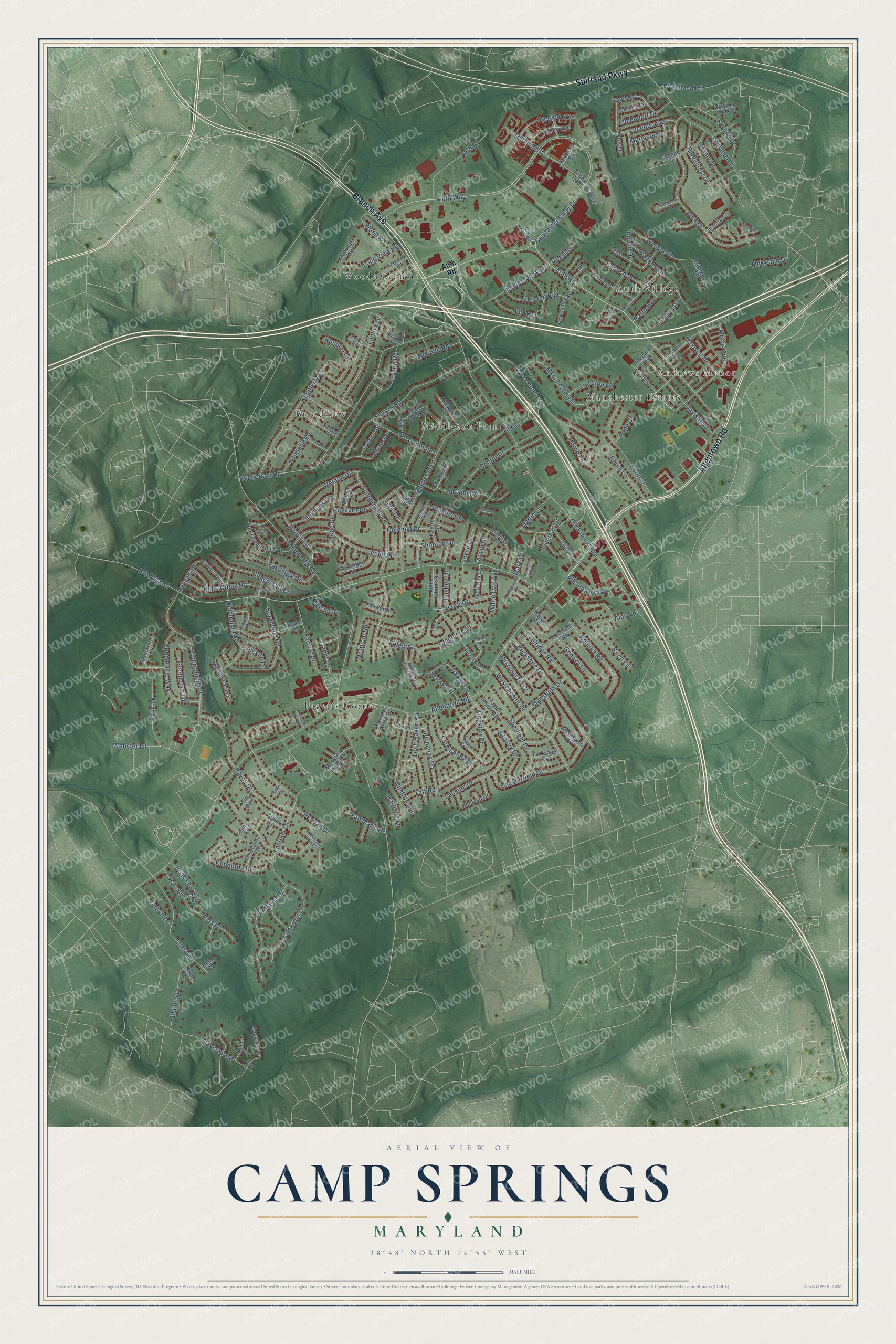
Camp Springs, Maryland Map Art
Building by building, with labeled streets and shaded relief.
12" x 18" Archival Matte Print
A Map of Home. A Work of Art.
Explore Camp Springs, Maryland from a whole new perspective. Created using aerial imagery and detailed geographic data, this map captures Camp Springs building by building, with labeled streets, familiar landmarks, and shaded topographical relief that highlights the natural contours of the landscape.
Combining modern data with the timeless character of a vintage atlas, this map is just as interesting up close as it is beautiful on the wall. Whether you grew up in Camp Springs, spent memorable years there, or call it home today, this unique map is a great way to celebrate a place that means something to you. Zoom in on the preview to look for your street, and then order a print to put your memories on the wall.
Three ways to hang it

Unframed archival matte, a black wood frame or a white wood frame.
Up close
Geography Worth Displaying
This map was created using accurate cartographic data and authoritative geographic sources, including the U.S. Geological Survey and the Census Bureau. The map brings together terrain, waterways, roads, and building detail. The majority of the streets are labeled, houses are accurately depicted, and the topography is derived from government sources. Combining local data with carefully composed color and shading leads to this beautifully detailed Camp Springs artwork for your wall.
Rather than simply showing street outlines, we’ve included as many of the street names as we could reasonably fit on the map while keeping their names legible. Zoom in on the high resolution preview to see exactly what’s on the map. We truly set out to create a statement piece for anyone who loves Camp Springs. So whether it’s for you, or a gift for someone you love, we hope this map of Camp Springs brings back fond memories.
Read the story behind this map of Camp Springs, Maryland from 2026.

Find your street
Names on the Camp Springs map
Every name below is printed on this map. Look for your street, your school, the park where you played, or the pond down the road.
Places and landmarks7
- Middleton Farm
- Pagetts Corner
- Auth Village
- Woods Corner
- Manchester Estates
- Andrews Manor
- Broadview
Streets and roads216
- Suitland Parkway
- Allentown Road
- Branch Avenue
- Auth Road
- Telfair Boulevard
- Auth Way
- Morris Avenue
- Kingston Drive
- Dodge Lane
- Temple Hill Road
- Brinkley Road
- Old Branch Avenue
- Capital Gateway Drive
- Henderson Road
- Keppler Road
- Webster Lane
- Lanham Lane
- Middleton Lane
- Summerhill Road
- John Street
- Lansing Drive
- Manchester Drive
- Auth Place
- Sharon Road
- Rayburn Drive
- Cherryfield Road
- Payne Drive
- Southfield Road
- Berkshire Drive
- Westchester Drive
Show all 216 streets
- Suitland Road
- Cimarron Lane
- Chesterfield Drive
- Weldon Drive
- Perrie Lane
- Cedell Place
- Dalton Street
- Lumar Drive
- Northam Road
- Birdsong Drive
- Leon Street
- Waldran Avenue
- Deer Pond Lane
- Walton Avenue
- Davis Boulevard
- Center Drive
- Copperville Way
- Taft Road
- Farmer Drive
- Edgemere Drive
- Sheffield Drive
- Skyline Drive
- Loch Raven Road
- Oaklawn Road
- Robinia Road
- Ludlow Drive
- Vernon Way
- Beachcraft Court
- Hope Drive
- Dublin Drive
- Middlefield Road
- Coolridge Road
- Kilbourne Drive
- Woodland Road
- Hartfield Avenue
- Buck Creek Road
- Henderson Way
- Tolson Road
- Keppler Place
- Gibbons Drive
- Lorraine Drive
- Huntland Road
- Joyce Drive
- Maxwell Drive
- Buchanan Road
- Lakeview Drive
- Karen Anne Drive
- Mansfield Drive
- Noah Drive
- Wessex Drive
- Cable Avenue
- Reamy Drive
- Lucente Avenue
- Pats Place
- Ridgecrest Drive
- Wesson Drive
- Acorn Drive
- Wills Lane
- Alcon Drive
- Elmendorf Drive
- Robin Lane
- Allentown Way
- Birch Lane
- Barto Avenue
- Simmons Lane
- Geneva Lane
- Gunston Lane
- Offut Drive
- Hill Way
- Yorkville Road
- Shopton Drive
- Vernon Drive
- Pendall Drive
- Ladd Road
- Harley Lane
- Long View Road
- Greenboro Lane
- Trueman Drive
- McKeldin Drive
- Marlin Lane
- Westchester Court
- Colonial Drive
- Wood Road
- White Oak Avenue
- Bushey Drive
- Jean Marie Drive
- Aley Road
- Roberts Drive
- Colon Terrace
- Wilkins Drive
- Janet Lane
- Maria Avenue
- Larwin Drive
- Pats Lane
- Harrison Lane
- Limekiln Drive
- Nile Place
- Gloria Drive
- Lujean Lane
- Pope Court
- Toby Drive
- Foley Terrace
- Mark Drive
- Midtown Square
- Telfair Way
- Tall Oak Drive
- Farmer Place
- Easy Street
- Old Temple Hills Road
- Kenstan Drive
- Lanier Avenue
- Newman Road
- Claridge Road
- Skyline Terrace
- Delta Lane
- Merchant Road
- Oakland Way
- Kenwood Street
- Middleton Court
- Middlefield Terrace
- Linda Lane
- Westridge Place
- Mackson Drive
- Flam Street
- John Adams Drive
- Tyburn Street
- Taylor Manor Avenue
- Gifford Lane
- Purdun Drive
- Glen Oak Drive
- Mansfield Manor Drive
- Medford Avenue
- Armand Avenue
- Westhaven Drive
- Bridgeport Drive
- Sapienza Drive
- Stoneridge Court
- Griffith Drive
- Clayton Lane Drive
- Stan Haven Road
- Yorkshire Drive
- Juanita Court
- Tamworth Court
- Maxwells Grant Court
- Kult Lane
- Tipton Drive
- Napoli Road
- Putt Road
- Arden Lane
- Pats Terrace
- Kae Court
- Camp Springs Avenue
- Carswell Avenue
- Darel Street
- Brentley Road
- Harvest Road
- Ashley's Crossing Court
- Redd Lane
- Allentown Farm Court
- Braddock Road
- Acton Road
- Woodbourne Avenue
- Goodfellow Drive
- Baywolf Street
- Colonial Terrace
- Penley Lane
- Old Soper Road
- Clacton Avenue
- Leah Court
- Allen Court
- Rose Court
- Braymer Avenue
- Lucerne Road
- Highgate Drive
- Greenline Court
- Howie Court
- Thuman Drive
- Peggyanne Court
- Anderson Drive
- Shopton Place
- English Court
- Brinkley Court
- Pleasant Hill Drive
- Trude Street
- Jolly Drive
- Konrad Drive
Names are listed as they appear on the printed map. Zoom into the product photos to find them.
About Camp Springs, Maryland
Camp Springs is a community of 22,734 people in Prince George's County, near the District of Columbia. It began in the mid-19th century as a settlement where Branch Avenue and Allentown Road now meet. By 1860 that crossroads held several stores, a blacksmith shop, a school, a Methodist church and a number of homes.
Early maps called the settlement Allentown, for the Allen family, who owned large tracts of land nearby and also gave their name to Allentown Road and Allenwood Elementary School. Local people called the place Camp Springs, though, and the post office took that name. Local history says soldiers marching from Washington to Fort Meade found the plentiful springs here a pleasant spot to stop and camp.
- A Rosenwald school in 1924In 1902 the county school commissioners voted to put up a schoolhouse for Camp Springs' Black children. By 1924 that one-room school held 78 pupils, and the children sold candy to raise money for a larger one. The county built a two-room school that year, paid for by Black families in the area together with the Julius Rosenwald Fund, and it became one of 24 Rosenwald schools in Prince George's County.
- Farms turned into neighborhoodsThe area grew little until after World War II, when the new air base next door, jobs in Washington and a housing shortage brought builders. In the 1940s the Middleton farm north of the crossroads was divided into Glenn Hills, Middleton Farm and Middleton Valley, and Guy Trueman laid out Trueman Heights on more than 100 acres to the northwest. In the 1950s Westchester Estates added over 400 houses on curving streets southwest of the crossroads.
- Waiting on water and sewerMost neighborhoods had no water or sewer lines until the late 1950s and early 1960s, which held building back. Once those lines were finished and the Capital Beltway was built, Camp Springs saw its biggest construction boom in the 1960s and 1970s.
- The old crossroads disappearsThe 19th-century crossroads faded away in the 20th century as Branch Avenue was rebuilt as a limited-access divided highway and stores and homes filled in around it. One of its last old businesses, Pyles Lumber Company, burned on December 27, 2000.
Keep exploring Maryland
Camp Springs is one of 881 Maryland towns we've mapped. Every dot on the map is a print of its own.
The search covers every state, Maryland first.
Near Camp Springs
Order 2 or more town maps and save 10%. Shown in the size and finish you picked above, so they hang as a set.
- Temple Hills 12" x 18" / Archival Matte Print $39.99
- Marlow Heights 12" x 18" / Archival Matte Print $39.99
- Morningside 12" x 18" / Archival Matte Print $39.99


More maps nearby: Silver Hill, Andrews AFB, Suitland, Oxon Hill and Hillcrest Heights.
The art of mapping a place
How This Map Was Made
Real places. Remarkable detail. Discover the layers that turn geographic data into a map of home.

The view from above
Aerial imagery reveals the character of the land: woodland, open fields, and the patterns of a place.

The shape of the land
Elevation data brings hills, valleys, and subtle changes in the landscape into view.

The details of home
Roads, waterways, and building footprints come together to make the map feel unmistakably local.

Geography becomes art
Considered color, shading, and typography bring the layers together in a map made for your wall.


Process illustrated with Mendon, Massachusetts. Aerial imagery: USDA NAIP. Terrain: USGS 3D Elevation Program. Map details and finished artwork: KNOWOL.
The Details
About This Print
Choose an archival matte print, or a black or white Ayous wood frame. The archival matte print is unframed.
Select your size and finish above to see the matching product image and price.
Materials & Craftsmanship
A contemporary map with the character of a classic atlas, printed on archival matte paper. Optional frames are made from Ayous wood.
Your printed map does not include the watermark shown in the full-map preview.
Shipping & Delivery
Free shipping within the United States. Every print is made to order in the USA.
Buying a gift? Add a note in your cart and we'll include it. We never put prices in the package.
Prints ship within 2 to 3 business days. Allow 7 to 10 days total from ordering for delivery. Timing may vary during holidays or periods of high order volume.
Read our shipping policy.
Returns and damaged prints
Each print is made to order. Change-of-mind refunds are not available after production.
If your print arrives damaged, misprinted or incorrect, contact support@knowol.com within 30 days of receiving it. Include your order number, photos and a description of the issue.
Read our full refund and replacement policy. For questions about your order, email support@knowol.com.