


Search for another town


Free U.S. delivery 7 to 10 days after you order
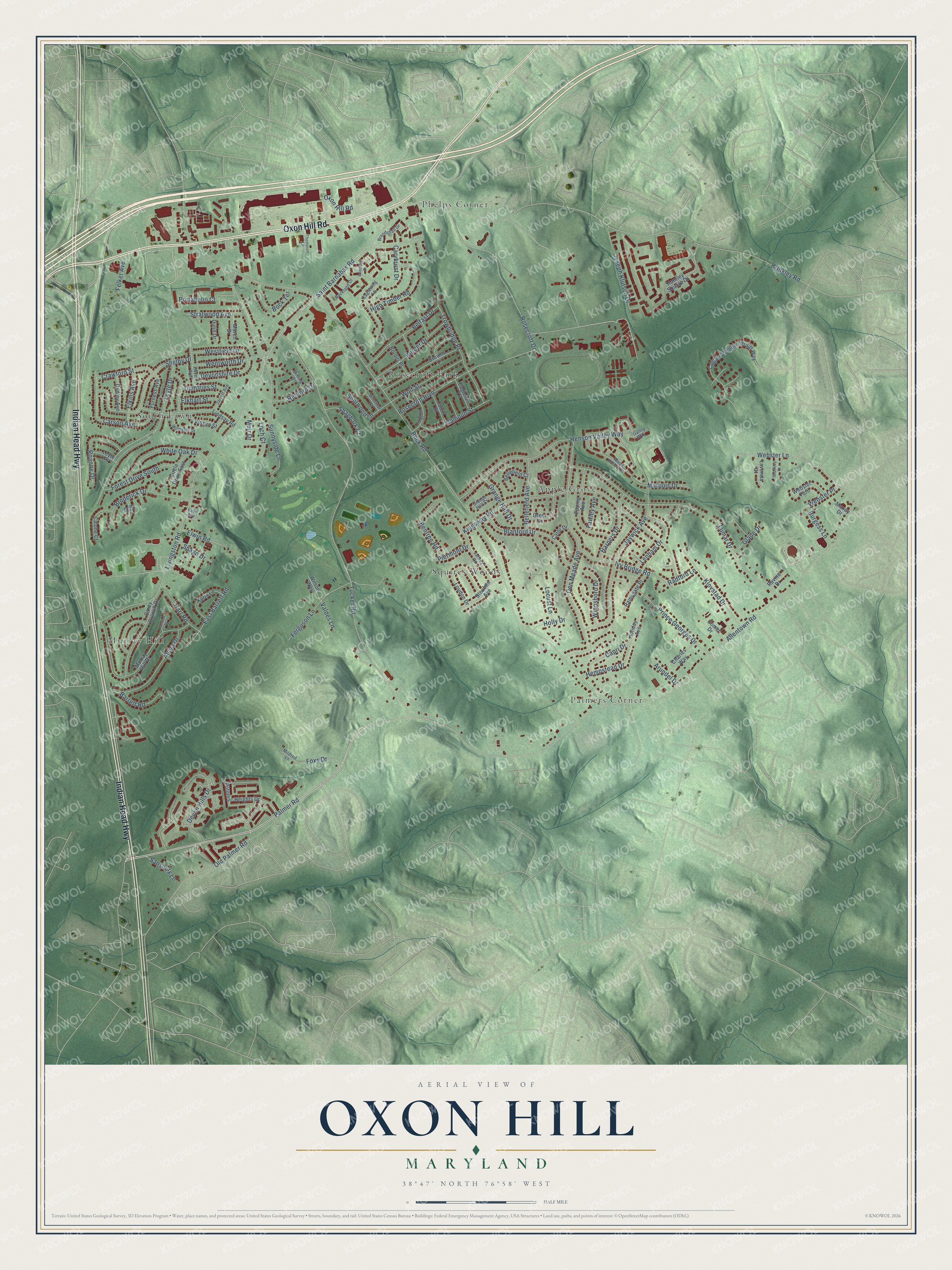
Oxon Hill, Maryland Map Art
Building by building, with labeled streets and shaded relief.
12" x 18" Archival Matte Print
A Map of Home. A Work of Art.
Explore Oxon Hill, Maryland from a whole new perspective. Created using aerial imagery and detailed geographic data, this map captures Oxon Hill building by building, with labeled streets, familiar landmarks, and shaded topographical relief that highlights the natural contours of the landscape.
Combining modern data with the timeless character of a vintage atlas, this map is just as interesting up close as it is beautiful on the wall. Whether you grew up in Oxon Hill, spent memorable years there, or call it home today, this unique map is a great way to celebrate a place that means something to you. Zoom in on the preview to look for your street, and then order a print to put your memories on the wall.
Three ways to hang it

Unframed archival matte, a black wood frame or a white wood frame.
Up close
Geography Worth Displaying
This map was created using accurate cartographic data and authoritative geographic sources, including the U.S. Geological Survey and the Census Bureau. The map brings together terrain, waterways, roads, and building detail. The majority of the streets are labeled, houses are accurately depicted, and the topography is derived from government sources. Combining local data with carefully composed color and shading leads to this beautifully detailed Oxon Hill artwork for your wall.
Rather than simply showing street outlines, we’ve included as many of the street names as we could reasonably fit on the map while keeping their names legible. Zoom in on the high resolution preview to see exactly what’s on the map. We truly set out to create a statement piece for anyone who loves Oxon Hill. So whether it’s for you, or a gift for someone you love, we hope this map of Oxon Hill brings back fond memories.
Read the story behind this map of Oxon Hill, Maryland from 2026.

Find your street
Names on the Oxon Hill map
Every name below is printed on this map. Look for your street, your school, the park where you played, or the pond down the road.
Places and landmarks7
- South Lawn
- Phelps Corner
- Palmers Corner
- Murray Hill
- Apple Grove
- Squires Woods
- Rosecroft Park
Streets and roads137
- Oxon Hill Road
- Indian Head Highway
- Palmer Road
- Saint Barnabas Road
- Bock Road
- Broderick Drive
- Prince Georges Drive
- Tucker Road
- Livingston Road
- Brinkley Road
- Kingsway Road
- Lumar Drive
- Allentown Road
- Leyte Drive
- Den Meade Avenue
- Jaywick Avenue
- Henson Valley Way
- Rosecroft Drive
- Old Palmer Road
- Rosecroft Boulevard
- Shelby Drive
- Webster Lane
- Trowbridge Place
- Sunnyside Lane
- Devon Hills Drive
- Carson Avenue
- Blanford Drive
- Alcoa Drive
- Ivy Bridge Road
- Klovstad Drive
Show all 137 streets
- White Oak Drive
- Belfast Drive
- Border Drive
- Ferguson Lane
- Caryhurst Drive
- High Timber Road
- Wolf Street
- Forest Drive South
- Joseph Klutsch Drive
- Calhoun Street
- Roanne Drive
- Lenham Drive
- Bellefield Avenue
- East Barrett Road
- Harpers Drive
- Marquis Drive
- Wentworth Drive
- Locust Lane
- Bentree Road
- Devonshire Drive
- Portabello Court
- Westfield Drive
- Bock Terrace
- Crawford Street
- Felker Avenue
- Hart Road
- Elkins Avenue
- Stratwood Avenue
- Sourwood Lane
- Winnsboro Drive
- Capri Drive
- Grange Hall Drive
- Shagbark Court
- Redford Drive
- Foxs Drive
- Elwin Road
- Burgess Lane
- Barrett Road
- Hempstead Drive
- Dumfries Street
- Loch Court
- Shago Drive
- Elkhart Street
- Fawley Avenue
- Glade Drive
- Sansbury Lane
- Webster Place
- Piermont Drive
- Holly Drive
- Arundel Drive
- Muir Drive
- Radford Lane
- Valdes Lane
- Potomac Heights Drive
- Murray Hill Drive
- Captain Wendell Pruitt Way
- Lindsay Road
- Epping Avenue
- Browns Lane
- Carey Branch Drive
- Loudon Drive
- Huntley Square Drive
- Steuben Avenue
- Karla Lane
- Holiday Avenue
- Greer Drive
- Catone Court
- Ramsgate Place
- Charles Way
- Furness Avenue
- Webster Turn
- Bellefield Court
- Dudley Avenue
- Border Place
- Circle Drive East
- Eagleton Lane
- Lavonda Court
- Vinson Street
- Calvin Street
- Wilson Way
- Comet Drive
- Dulin Drive
- March Drive
- Leyte Place
- Ben Drive
- Ravine Drive
- Cator Drive
- Maxey Drive
- Wood Hollow Place
- Gallop Way
- Jaffrey Road
- Eaglewing Lane
- Haven Avenue
- Wilmette Drive
- Brandyhall Drive
- Jarrett Avenue
- Grange Hall Court
- Buckland Drive
- Stirling Street
- Bitternut Court
- Mildred Lane
- Busit Avenue
- Bentham Drive
- Haverhill Street
- Thompson Lane
- Shockley Court
- Prentice Court
Names are listed as they appear on the printed map. Zoom into the product photos to find them.
About Oxon Hill, Maryland
Oxon Hill is a community of 18,791 people in Prince George's County, just south of the Washington line. It takes its name from the 18th-century manor house of Thomas Addison, who thought this land looked like the country around Oxford, England. "Oxon" is short for the Latin word Oxoniensis, which means "of Oxford."
Until about 1960, letters to Oxon Hill carried a Washington, D.C., address, because the community had no postal name of its own. Suburban building began in the 1940s, and garden apartments, townhouses and houses kept going up into the early 1990s. About 1980 the Postal Service moved the two-thirds of greater Oxon Hill farthest from Washington into a new postal area called Fort Washington, and in 2008 the National Harbor development opened on the Potomac shore.
- Black Methodists since 1791In 1791 Ezekiel Cooper preached to African American Methodists in Oxon Hill, inside a small preaching house they had put up with their own hands. Their congregation, now St. Paul's United Methodist Church, may be the county's oldest Black congregation. In 1887 minister Daniel Wheeler and the trustees bought land and raised a small frame church, which was used until the present church replaced it in 1915.
- St. Ignatius, founded in 1849Father Joseph M. Finotti, a Jesuit priest and the first Catholic anthologist in the country, founded St. Ignatius Church on Brinkley Road in 1849. The frame church that stands today went up around 1890, when Charles Beers, a contractor from Anacostia, built it for $5,000. St. Ignatius Church is listed on the National Register of Historic Places.
- A manor on the Potomac bluffThe Revolutionary patriot John Hanson died while visiting Addison's colonial manor and may lie there in an unmarked grave. That house burned in 1895, and in 1929 a 49-room neo-Georgian house, Oxon Hill Manor, rose on a bluff above the Potomac. Sumner Welles, Franklin D. Roosevelt's Undersecretary of State, lived there and hosted Roosevelt. The Maryland-National Capital Park and Planning Commission now owns it and uses it for cultural events and weddings.
- The Wilson Bridge, 1961The Capital Beltway cuts through Oxon Hill and crosses the Potomac on the Woodrow Wilson Bridge, built in 1961. For decades 250,000 to 300,000 vehicles a day used the bridge, and traffic backed up into the community every day. A larger bridge opened on December 15, 2008, and the nearby ramps and interchanges were rebuilt along with it.
Keep exploring Maryland
Oxon Hill is one of 881 Maryland towns we've mapped. Every dot on the map is a print of its own.
The search covers every state, Maryland first.
Near Oxon Hill
Order 2 or more town maps and save 10%. Shown in the size and finish you picked above, so they hang as a set.
- Temple Hills 12" x 18" / Archival Matte Print $39.99
- Friendly 12" x 18" / Archival Matte Print $39.99
- National Harbor 12" x 18" / Archival Matte Print $39.99


More maps nearby: Glassmanor, Forest Heights, Marlow Heights, Camp Springs and Hillcrest Heights.
The art of mapping a place
How This Map Was Made
Real places. Remarkable detail. Discover the layers that turn geographic data into a map of home.

The view from above
Aerial imagery reveals the character of the land: woodland, open fields, and the patterns of a place.

The shape of the land
Elevation data brings hills, valleys, and subtle changes in the landscape into view.

The details of home
Roads, waterways, and building footprints come together to make the map feel unmistakably local.

Geography becomes art
Considered color, shading, and typography bring the layers together in a map made for your wall.


Process illustrated with Mendon, Massachusetts. Aerial imagery: USDA NAIP. Terrain: USGS 3D Elevation Program. Map details and finished artwork: KNOWOL.
The Details
About This Print
Choose an archival matte print, or a black or white Ayous wood frame. The archival matte print is unframed.
Select your size and finish above to see the matching product image and price.
Materials & Craftsmanship
A contemporary map with the character of a classic atlas, printed on archival matte paper. Optional frames are made from Ayous wood.
Your printed map does not include the watermark shown in the full-map preview.
Shipping & Delivery
Free shipping within the United States. Every print is made to order in the USA.
Buying a gift? Add a note in your cart and we'll include it. We never put prices in the package.
Prints ship within 2 to 3 business days. Allow 7 to 10 days total from ordering for delivery. Timing may vary during holidays or periods of high order volume.
Read our shipping policy.
Returns and damaged prints
Each print is made to order. Change-of-mind refunds are not available after production.
If your print arrives damaged, misprinted or incorrect, contact support@knowol.com within 30 days of receiving it. Include your order number, photos and a description of the issue.
Read our full refund and replacement policy. For questions about your order, email support@knowol.com.