


Search for another town





Free U.S. delivery 7 to 10 days after you order
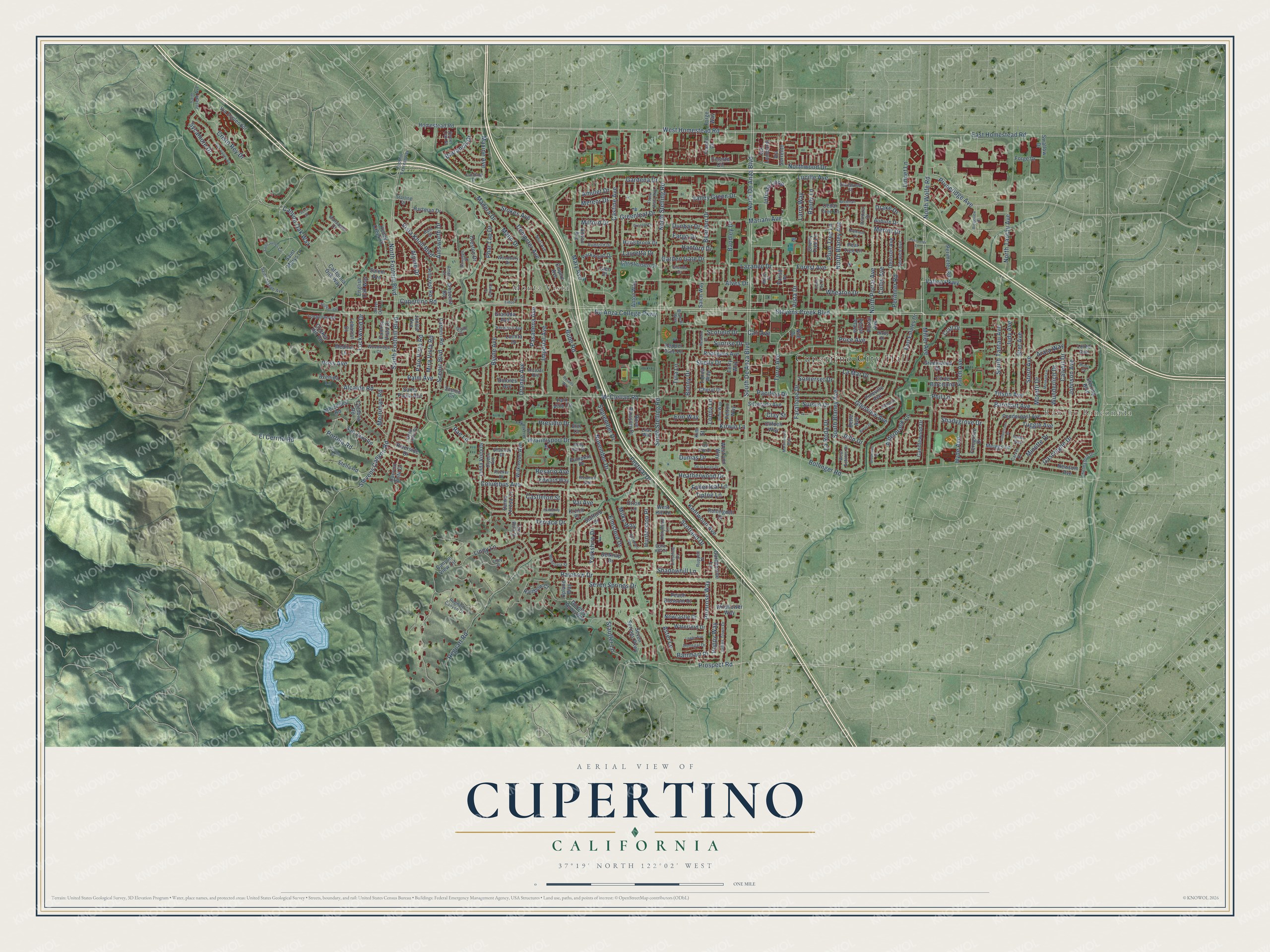
Cupertino, California Map Art
Building by building, with labeled streets and shaded relief.
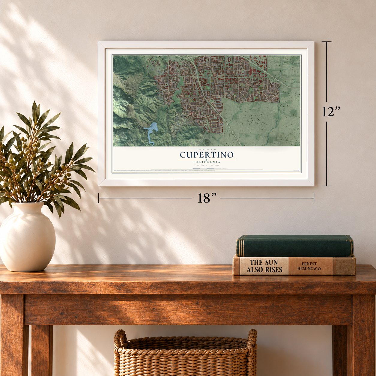
12" x 18" Archival Matte Print
A Map of Home. A Work of Art.
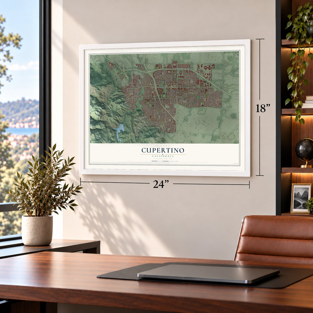
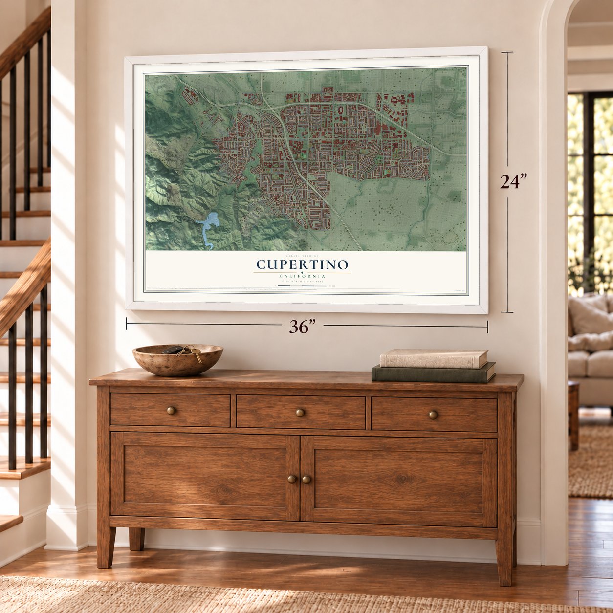
Explore Cupertino, California from a whole new perspective. Created using aerial imagery and detailed geographic data, this map captures Cupertino building by building, with labeled streets, familiar landmarks, and shaded topographical relief that highlights the natural contours of the landscape.
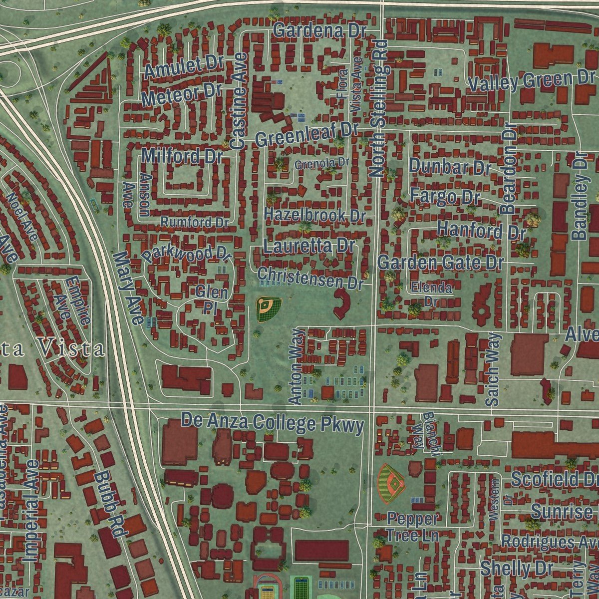
Combining modern data with the timeless character of a vintage atlas, this map is just as interesting up close as it is beautiful on the wall. Whether you grew up in Cupertino, spent memorable years there, or call it home today, this unique map is a great way to celebrate a place that means something to you. Zoom in on the preview to look for your street, and then order a print to put your memories on the wall.
Three ways to hang it
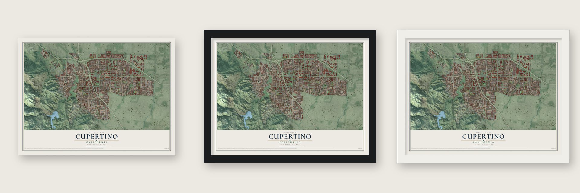
Unframed archival matte, a black wood frame or a white wood frame.
Up close
Geography Worth Displaying
This map was created using accurate cartographic data and authoritative geographic sources, including the U.S. Geological Survey and the Census Bureau. The map brings together terrain, waterways, roads, and building detail. The majority of the streets are labeled, houses are accurately depicted, and the topography is derived from government sources. Combining local data with carefully composed color and shading leads to this beautifully detailed Cupertino artwork for your wall.
Rather than simply showing street outlines, we’ve included as many of the street names as we could reasonably fit on the map while keeping their names legible. Zoom in on the high resolution preview to see exactly what’s on the map. We truly set out to create a statement piece for anyone who loves Cupertino. So whether it’s for you, or a gift for someone you love, we hope this map of Cupertino brings back fond memories.
Read the story behind this map of Cupertino, California from 2026.

Find your street
Names on the Cupertino map
Every name below is printed on this map. Look for your street, your school, the park where you played, or the pond down the road.
Places and landmarks3
- Cupertino City Hall
- Rancho Rinconada
- Monta Vista
Streets and roads330
- Stevens Creek Boulevard
- North Wolfe Road
- North Foothill Boulevard
- Prospect Road
- Forest Avenue
- Infinite Loop
- South Foothill Boulevard
- Mariani Avenue
- West Homestead Road
- Lazaneo Drive
- Cristo Rey Drive
- Mary Avenue
- Barranca Drive
- Maxine Avenue
- North De Anza Boulevard
- Rae Lane
- South De Anza Boulevard
- Vista Drive
- East Homestead Road
- South Stelling Road
- McClellan Road
- Regnart Road
- De Anza College Parkway
- Rainbow Drive
- Bubb Road
- Bollinger Road
- Miller Avenue
- Stevens Canyon Road
- North Blaney Avenue
- North Tantau Avenue
Show all 330 streets
- Lindy Lane
- North Stelling Road
- El Cerrito Road
- South Blaney Avenue
- Seven Springs Drive
- South Tantau Avenue
- Pruneridge Avenue
- Columbus Avenue
- Johnson Avenue
- Wunderlich Drive
- Bandley Drive
- Tilson Avenue
- Voss Avenue
- Vallco Parkway
- Alves Drive
- Greenleaf Drive
- North Portal Avenue
- November Drive
- Barnhart Avenue
- Valley Green Drive
- Beardon Drive
- Scenic Boulevard
- Farallone Drive
- Merritt Drive
- Phar Lap Drive
- Pacifica Drive
- Orange Avenue
- Randy Lane
- Hyannisport Drive
- Stokes Avenue
- Byrne Avenue
- Torre Avenue
- Mann Drive
- Kirwin Lane
- Imperial Avenue
- Finch Avenue
- Canyon Oak Way
- Judy Avenue
- Bret Avenue
- Perimter Road
- Lockwood Drive
- Stern Avenue
- Wheaton Drive
- Glenview Avenue
- Primrose Way
- Yorkshire Drive
- Poppy Way
- John Drive
- Gascoigne Drive
- Mira Vista Road
- Aster Lane
- Bonny Drive
- Stauffer Lane
- September Drive
- Castine Avenue
- Vista Knoll Boulevard
- Colby Avenue
- Alderbrook Lane
- Scofield Drive
- Merriman Road
- Alpine Drive
- Linnet Lane
- Cupertino Road
- La Mar Drive
- Festival Drive
- Terrace Drive
- Phil Lane
- Calvert Drive
- Portola Road
- Fallenleaf Lane
- Elmsford Drive
- Garden Gate Drive
- Madera Drive
- Ainsworth Drive
- Heatherwood Drive
- Kentwood Avenue
- Alcalde Road
- Dempster Avenue
- Dumas Drive
- Gardena Drive
- Sycamore Drive
- Barnhart Place
- Shadygrove Drive
- Lauretta Drive
- La Roda Drive
- Plum Tree Lane
- Larry Way
- Dunbar Drive
- Shelly Drive
- Palm Avenue
- Presidio Drive
- Sunrise Drive
- Lucille Avenue
- Pasadena Avenue
- Fargo Drive
- Palo Vista Road
- Erin Way
- Minette Drive
- Castleton Street
- Hyde Avenue
- Rosario Avenue
- Hunterston Place
- Scotland Drive
- Meteor Drive
- Tiptoe Lane
- Shadowhill Lane
- Tuggle Avenue
- Northwood Drive
- Hanford Drive
- Moretti Drive
- Somerset Drive
- Suisun Drive
- Drake Drive
- Arata Way
- Amulet Drive
- Price Avenue
- Milford Drive
- Milky Way
- Vai Avenue
- Cali Avenue
- Tula Lane
- Lonna Lane
- Clay Street
- Via Sorrento
- Forge Way
- Via Lombardi
- Franco Court
- Anson Avenue
- East Estates Drive
- Rodrigues Avenue
- Via Esplendor
- Linda Vista Drive
- Parkwood Drive
- Loree Avenue
- California Oak Way
- Sterling Boulevard
- Seven Springs Parkway
- Santa Teresa Drive
- Upland Way
- Scenic Circle
- Stafford Drive
- Wilkinson Avenue
- Pendergast Avenue
- San Juan Road
- Newsom Avenue
- Denison Avenue
- Rose Blossom Drive
- Canyon View Circle
- Perimeter Road
- Celeste Circle
- Westlynn Way
- Waterford Drive
- Salem Avenue
- Granada Avenue
- Carmen Road
- Cordova Road
- Parish Place
- Park Villa Circle
- Janice Avenue
- Peach Blossom Drive
- Saint Marys Drive
- Crescent Road
- Candlewood Drive
- Clifden Way
- Christensen Drive
- Kim Street
- Homestead Road
- Pineville Avenue
- Hazelbrook Drive
- Riverside Drive
- Silverado Avenue
- Creston Drive
- Heney Creek Place
- Rainbow Court
- Lebanon Drive
- Orion Lane
- Hillcrest Road
- Rollingdell Drive
- Santa Paula Avenue
- Pepper Tree Lane
- Newcastle Drive
- Nile Drive
- Ferngrove Drive
- Bette Avenue
- Cricket Hill Road
- Cll de Barcelona
- Dorothy Anne Way
- Gardenside Lane
- Mercedes Road
- Belknap Drive
- Felton Way
- Edward Way
- Hartman Drive
- Canyon Vista Drive
- Greenwood Drive
- Portal Plaza
- Avenida Lane
- Saich Way
- Dolores Avenue
- English Oak Way
- Lomita Drive
- Stella Road
- Cherry Tree Lane
- Tonita Way
- Wildflower Way
- Anton Way
- Auburn Drive
- Cheryl Drive
- Camino Vista Drive
- Meiggs Lane
- Pear Tree Lane
- Pumpkin Drive
- Empire Avenue
- Swallow Drive
- Medina Lane
- Forge Drive
- Portal Avenue
- Terry Way
- Craft Drive
- Cedar Tree Lane
- Krzich Place
- Glen Place
- West Hill Lane
- Elm Court
- James Town Drive
- Caroline Drive
- Regnart Canyon Drive
- Chelmsford Drive
- Foothill Expressway
- Flora Vista Avenue
- De Foe Drive
- Alcazar Avenue
- Saint Joseph Avenue
- Carver Drive
- Olivewood Street
- Norwich Avenue
- Longdown Road
- West Estates Drive
- Woodridge Court
- Donegal Drive
- Miner Place
- Sweet Oak Street
- Crestline Drive
- Rumford Drive
- Deep Cliffe Drive
- Woodbury Drive
- Manzanita Court
- Hermosa Avenue
- John Way
- Monrovia Street
- Noel Avenue
- Silver Oak Lane
- Bahl Street
- Bianchi Way
- Lilac Way
- Ruppell Place
- Holly Oak Drive
- Hollyhead Lane
- Dryden Avenue
- Shattuck Drive
- Starling Drive
- Terra Bella Drive
- Bixby Drive
- Deodara Drive
- Rucker Drive
- Amelia Court
- Elenda Drive
- Echo Hill Court
- Runo Court
- Dean Court
- Eaton Place
- Oak Valley Road
- Stonebridge
- Menhart Lane
- Brookwell Drive
- Culbertson Drive
- Saint James Circle
- Baywood Drive
- Robindell Way
- Grenola Drive
- Stonydale Drive
- De la Farge Drive
- Ridgeview Court
- Lindy Place
- Rampart Avenue
- Martinwood Way
- Brent Drive
- Western Drive
- Paloma Road
- Leeds Avenue
- Woodlark Way
- Perimeter Lane
- Beekman Place
- Serra Street
- Flintshire Street
- Fort Baker Drive
- Oakleaf Place
- Results Way
- Hunter Way
- Carol Lee Drive
Names are listed as they appear on the printed map. Zoom into the product photos to find them.
About Cupertino, California
Cupertino is a city of 60,381 people in Santa Clara County, where the flat western edge of the Santa Clara Valley climbs into the Santa Cruz Mountains. In the 19th century it was a small farm village called the West Side, part of Fremont Township, gathered where Stevens Creek Road crossed the road from Saratoga to Mountain View. Prune, plum, apricot and cherry orchards covered nearly all the land, and the R. Cali Brothers Feed Mill stood for decades on the southeast corner of that crossroads, where Cali Mill Plaza and City Hall are today.
An electric railway later crossed the farmland, and Monta Vista grew up along it as the area's first housing tract. The housing boom after World War II brought many new residents to the valley. In 1954 rancher Norman Nathanson, working with two local groups, the Fact Finding Committee and the Cupertino-Monta Vista Improvement Association, led a push to incorporate. Voters said yes on September 27, 1955, by 225 to 183, and on October 10, 1955, Cupertino became the county's 13th city.
“This arroyo honoring San Joseph, patron saint of flight and students, was first discovered and traversed by Spanish explorers in 1769.”
- A name from a creekThe cartographer traveling with Juan Bautista de Anza named a local stream Arroyo San José de Cupertino, for Saint Joseph of Cupertino. The stream is now Stevens Creek. The name caught on after John T. Doyle, a lawyer and historian from San Francisco, called his McClellan Road winery Cupertino, and once the 20th century began it replaced West Side as the name for the whole area.
- Orchards became VALLCO ParkIn the early 1960s, the area's biggest landowners turned their farms into the VALLCO Business and Industrial Park. Of 25 owners, 17 pooled their land, 6 sold to Varian Associates, whose property later went to Hewlett-Packard, and two moved their farming elsewhere. The name joins Varian with the Leonard, Lester, Craft and Orlando families. A shopping center followed, and later the enclosed Vallco Fashion Park, which was torn down in the early 21st century.
- A college on a wineryDe Anza College, named for the Spanish explorer, opened in 1967 on a 112-acre site. As the 20th century began, Charles and Ella Baldwin had built a winery there that they called Beaulieu, and their mansion now houses the California History Center. The college had 16,335 students in 2022.
- Cement for Shasta DamHenry J. Kaiser founded the Kaiser Permanente Cement Plant in the foothills west of Cupertino in 1939. It sent 6 million barrels of cement over a conveyor nine miles long, most of what went into Shasta Dam. The railroad line through the city was built only to serve the plant, which Lehigh Southwest Cement now runs as the Permanente Quarry.
- Apple ParkHewlett-Packard moved its Bay Area workers to Palo Alto in 2010 and shut its Cupertino campus, and Apple bought the site. On June 7, 2011, Steve Jobs showed the Cupertino City Council his plans for a new headquarters there. Apple Park now fills 150 acres, with 13,000 employees working in one round, four-story building ringed by landscaping.
Keep exploring California
Cupertino is one of 1,990 California towns we've mapped. Every dot on the map is a print of its own.
The search covers every state, California first.
Near Cupertino
Order 2 or more town maps and save 10%. Shown in the size and finish you picked above, so they hang as a set.
- Rancho Rinconada 12" x 18" / Archival Matte Print $39.99
- Loyola 12" x 18" / Archival Matte Print $39.99
- Saratoga 12" x 18" / Archival Matte Print $39.99


More maps nearby: Los Altos, Sunnyvale, Santa Clara, Campbell and Mountain View.
The art of mapping a place
How This Map Was Made
Real places. Remarkable detail. Discover the layers that turn geographic data into a map of home.

The view from above
Aerial imagery reveals the character of the land: woodland, open fields, and the patterns of a place.

The shape of the land
Elevation data brings hills, valleys, and subtle changes in the landscape into view.

The details of home
Roads, waterways, and building footprints come together to make the map feel unmistakably local.

Geography becomes art
Considered color, shading, and typography bring the layers together in a map made for your wall.


Process illustrated with Mendon, Massachusetts. Aerial imagery: USDA NAIP. Terrain: USGS 3D Elevation Program. Map details and finished artwork: KNOWOL.
The Details
About This Print
Choose an archival matte print, or a black or white Ayous wood frame. The archival matte print is unframed.
Select your size and finish above to see the matching product image and price.
Materials & Craftsmanship
A contemporary map with the character of a classic atlas, printed on archival matte paper. Optional frames are made from Ayous wood.
Your printed map does not include the watermark shown in the full-map preview.
Shipping & Delivery
Free shipping within the United States. Every print is made to order in the USA.
Buying a gift? Add a note in your cart and we'll include it. We never put prices in the package.
Prints ship within 2 to 3 business days. Allow 7 to 10 days total from ordering for delivery. Timing may vary during holidays or periods of high order volume.
Read our shipping policy.
Returns and damaged prints
Each print is made to order. Change-of-mind refunds are not available after production.
If your print arrives damaged, misprinted or incorrect, contact support@knowol.com within 30 days of receiving it. Include your order number, photos and a description of the issue.
Read our full refund and replacement policy. For questions about your order, email support@knowol.com.