
Search for another town


Free U.S. delivery 7 to 10 days after you order
Hastings, Massachusetts Map Art
Building by building, with labeled streets and shaded relief.
12" x 18" Archival Matte Print
A Map of Home. A Work of Art.
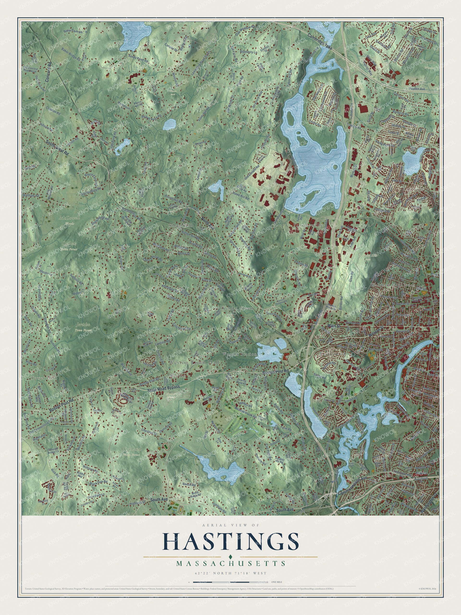
Explore Hastings, Massachusetts from a whole new perspective. Created using aerial imagery and detailed geographic data, this map captures Hastings building by building, with labeled streets, familiar landmarks, and shaded topographical relief that highlights the natural contours of the landscape.
Combining modern data with the timeless character of a vintage atlas, this map is just as interesting up close as it is beautiful on the wall. Whether you grew up in Hastings, spent memorable years there, or call it home today, this unique map is a great way to celebrate a place that means something to you. Zoom in on the preview to look for your street, and then order a print to put your memories on the wall.
Three ways to hang it

Unframed archival matte, a black wood frame or a white wood frame.
Up close
Geography Worth Displaying
This map was created using accurate cartographic data and authoritative geographic sources, including the U.S. Geological Survey and the Census Bureau. The map brings together terrain, waterways, roads, and building detail. The majority of the streets are labeled, houses are accurately depicted, and the topography is derived from government sources. Combining local data with carefully composed color and shading leads to this beautifully detailed Hastings artwork for your wall.
Rather than simply showing street outlines, we’ve included as many of the street names as we could reasonably fit on the map while keeping their names legible. Zoom in on the high resolution preview to see exactly what’s on the map. We truly set out to create a statement piece for anyone who loves Hastings. So whether it’s for you, or a gift for someone you love, we hope this map of Hastings brings back fond memories.
Read the story behind this map: Detailed Map of Hastings, Massachusetts.

Find your street
Names on the Hastings map
Every name below is printed on this map. Look for your street, your school, the park where you played, or the pond down the road.
Places and landmarks19
- Weston Town Hall
- Tower Hill
- Lakeview
- Hayden Woods
- Highland Town Forest
- Jericho Town Forest
- Linwood Cemetery
- McDowell Woods
- Ogilvie Town Forest
- Pierce Park
- Prospect Hill Park
- Cedarwood
Show all 19 places
- Silver Hill
- Kendal Green
- Prospectville
- Weston
- Weston Station
- Waltham Highlands
- Kendall Park
Streets and roads433
- Boston Post Road
- Weston Street
- State Road Bypass
- South Avenue
- Commonwealth Avenue
- Main Street
- North Avenue
- Concord Road
- South Great Road
- Cambridge Turnpike
- Washington Street
- Wyman Street
- Spring Street
- Smith Street
- Ridge Lane
- Third Avenue
- Prospect Street
- Lincoln Street
- Winter Street
- Totten Pond Road
- Plympton Street
- Maple Street
- Rumford Avenue
- Melrose Street
- Fir Avenue
- Trapelo Road
- Lexington Street
- Conant Road
- Lincoln Road
- Tower Road
Show all 433 streets
- Old County Road
- Highland Street
- Wellesley Street
- Ash Street
- Meadowbrook Road
- Weston Road
- Newton Street
- South Street
- Merriam Street
- Crescent Street
- Summer Street
- Auburn Street
- Glen Road
- Lexington Road South
- Church Street
- Page Road
- Chestnut Street
- Rice Road
- Draper Road
- Sandy Pond Road
- School Street
- Buckskin Drive
- Baker Bridge Road
- Moody Street
- Silver Hill Road
- Old Sudbury Road
- Codman Road
- Woodland Road
- Charles Street
- Bacon Street
- Central Street
- Concord Avenue
- Sears Road
- Highland Circle
- Plain Road
- Lake Street
- Westerly Road
- Hayden Avenue
- Second Avenue
- Pine Street
- River Road
- Norumbega Road
- Cherry Brook Road
- Sibley Road
- Bear Hill Road
- Shade Street
- Dale Street
- Montvale Road
- Beaver Pond Road
- Auburndale Avenue
- Thornton Road
- Bedford Road
- Old Connecticut Path
- Loring Road
- Sudbury Road
- Kings Grant Road
- Todd Pond Road
- Love Lane
- Worcester Lane
- Robin Road
- Fox Road
- Rolling Lane
- Warren Avenue
- Blackburnian Road
- Sunset Road
- Adams Street
- Hardy Pond Road
- Bakers Hill Road
- Riverview Avenue
- Hillcrest Road
- Deer Path Lane
- Black Oak Road
- Viles Street
- Felton Street
- Rowe Street
- Pine Hill Circle
- Westland Road
- Jericho Road
- Old Winter Street
- Hammond Street
- Stonehedge Road
- Grove Street
- Bradford Road
- Old Conant Road
- Fairbanks Road
- Villa Street
- Glezen Lane
- Berkley Street
- Bay State Road
- Shire Way
- Charles River Road
- Robbins Street
- Rich Valley Road
- Woodcliffe Road
- Copeland Street
- West Street
- Oak Meadow Road
- Barberry Road
- Baker Farm Road
- Fifth Avenue
- Decatur Lane
- Standish Road
- Bedford Street
- Lura Lane
- Possum Road
- Old Road
- Brook Road
- Russell Street
- Aberdeen Road
- Round Hill Road
- Nobscot Road
- Grassland Street
- Spruce Hill Road
- Bridge Street
- Greenwood Lane
- Patriot Way
- Hallett Hill Road
- Hancock Street
- Laurel Drive
- Hibiscus Avenue
- Blueberry Lane
- White Road
- Ripley Lane
- Young Road
- Tabor Hill Road
- Tufts Road
- Tracer Lane
- Clark Lane
- Candlewood Drive
- Cary Avenue
- Laurel Road
- Hidden Road
- Farm Road
- Hillside Road
- Colchester Road
- Cart Path Road
- Coburn Road
- Georgian Road
- Bradyll Road
- Munroe Road
- Canaan Drive
- Montclair Avenue
- Autumn Road
- River Street
- Webster Street
- Boyce Farm Road
- Stow Street
- Pond Street
- Edgewater Drive
- Indian Road
- Stratford Way
- Juniper Road
- Freeman Street
- Bemis Street
- Spring Road
- Midland Drive
- Roberts Road
- Gregory Street
- Prentice Street
- Sherbourne Place
- Old Farm Road
- Willard Road
- Laxfield Road
- Dobbins Street
- Gatehouse Lane
- Adams Avenue
- Orange Street
- Lunda Street
- Trailside Road
- Derby Street
- Grant Street
- Fiske Avenue
- Legion Road
- Harland Road
- Hawk Hill Road
- Jennings Road
- Waltham Road
- Forester Road
- Miriam Road
- Guinan Street
- Wells Road
- Lake Avenue
- Tudor Street
- Hope Avenue
- Highfields
- Border Road
- Albert Road
- Astra
- Derby Lane
- Beech Road
- Perry Lane
- Cove Street
- Ware Street
- Leslie Road
- Giles Road
- Sun Street
- Alder Street
- Weir Road
- Winsor Way
- Davison Drive
- Ridge Road
- Athletic Field Road
- Prospect Hill Road
- Stearns Hill Road
- Islington Road
- Pigeon Hill Road
- Highland Meadows Lane
- Black Bear Drive
- Old Concord Road
- Fairview Road
- Lakeview Avenue
- Drabbington Way
- Doublet Hill Road
- Myles Standish Road
- Country Drive
- Sheffield Road
- Huckleberry Hill Road
- Indian Hill Road
- Kodiak Way
- Long Meadow Road
- Golden Ball Road
- Skating Pond Road
- Pinecroft Road
- Audubon Road
- Kingston Road
- Arrowhead Road
- Amherst Avenue
- Graymore Road
- Vernon Street
- Pine Brook Road
- Hudson Road
- Curve Street
- Applecrest Road
- Old South Street
- Windermere Road
- Hickory Drive
- Rockridge Road
- Columbus Avenue
- Red Rail Farm
- October Lane
- Warbler Springs Road
- Phinney Road
- Prospect Hill Lane
- Lover Field Road
- Partridge Hill Road
- Westway Road
- Autumn Lane
- Storey Drive
- Sylvan Road
- First Avenue
- Fiske Street
- Forest Ridge Road
- Galen Street
- Sawyer Road
- Chadwick Road
- Morton Street
- Whitney Tavern
- Bigelow Road
- Silver Hill Lane
- Twin Pond Lane
- West Pine Street
- Covered Bridge Lane
- Sylvan Way
- Washington Avenue
- Exchange Street
- Old Concord Road North
- Jones Road
- Rich Street
- Turner Street
- Williston Road
- Overlook Drive
- Overland Road
- Magnolia Drive
- Cabin Road
- Robinhood Street
- Agrillo Circle
- Market Place Drive
- Whitehouse Lane
- Field Road
- Newell Road
- Mackintosh Lane
- Browning Lane
- Sanderson Lane
- Green Lane
- Wood Ridge Road
- Walnut Street
- Carroll Circle
- Loretta Road
- Cutters Bluff
- Turkey Hill Road
- Old Coach Road
- Curtis Street
- Ware Road
- South Brook Road
- Whittier Avenue
- Atlas Lane
- Maple Road
- Everett Street
- Alphabet Lane
- Gypsy Trail
- Hays Road
- Winston Road
- Page Farm Road
- Hayfield Lane
- Middle Way
- Larkin Road
- Pine Vale Road
- Peirce Hill Road
- Tavern Road
- Glen Circle
- Plant Road
- Sutton Place
- Orris Street
- Star Road
- Craig Lane
- Ionia Street
- Goldencrest Avenue
- College Farm Road
- Black Burnian Road
- Seminole Avenue
- Ballfield Road
- Wolcott Street
- Hobbs Brook Road
- Livermore Lane
- Irving Street
- Stony Brook Road
- Forest Grove Road
- Beaver Street
- Kendal Common Road
- Hitching Post Lane
- Winthrop Street
- Fox Chase Lane
- Coolidge Road
- Wildflower Lane
- Fourth Avenue
- Caughey Street
- Sunday Woods Road
- Fern Street
- Blossom Lane
- Oldham Road
- Linwood Avenue
- Vista Avenue
- Chaske Avenue
- High Street
- Granville Road
- Hansen Road
- Spruce Street
- Fox Hollow
- Village Road
- Claridge Drive
- Pelham Road
- Common Street
- Irving Road
- Aspen Road
- Warren Place
- Nutting Road
- Bridle Path
- Melody Lane
- Willow Road
- Gowell Lane
- Casey Circle
- Kings Way
- Green Street
- Ames Street
- Water Street
- River Path
- Joy Street
- Mokema Avenue
- Whispering Lane
- Lincoln Woods Road
- Milton Street
- Angleside Road
- Woerd Avenue
- Hilltop Road
- Greenridge Lane
- Woodbine Street
- Francis Street
- Old North Avenue
- Kingswood Road
- Wheelock Road
- Minebrook Road
- Dellbrook Road
- Rosemont Avenue
- East Cedar Road
- Terrace Road
- Chester Avenue
- Webster Lane
- Myrtle Avenue
- Cutler Farm Road
- Emerson Road
- Taylor Street
- Fields Pond Road
- Lake Road
- Whitlowe Road
- Pheasant Trail
- Philips Terrace
- Wingate Road
- Jericho Lane
- Upland Field Road
- Emery Street
- Park Road
- Night Cap Lane
- Acorn Lane
Names are listed as they appear on the printed map. Zoom into the product photos to find them.
Keep exploring Massachusetts
Hastings is one of 470 Massachusetts towns we've mapped. Every dot on the map is a print of its own.
The search covers every state, Massachusetts first.
Near Hastings
Order 2 or more town maps and save 10%. Shown in the size and finish you picked above, so they hang as a set.
- Weston 12" x 18" / Archival Matte Print $39.99
- Waltham 12" x 18" / Archival Matte Print $39.99
- Lincoln 12" x 18" / Archival Matte Print $39.99

More maps nearby: Wayland, Lexington, Cochituate, Belmont and Newton.
The art of mapping a place
How This Map Was Made
Real places. Remarkable detail. Discover the layers that turn geographic data into a map of home.

The view from above
Aerial imagery reveals the character of the land: woodland, open fields, and the patterns of a place.

The shape of the land
Elevation data brings hills, valleys, and subtle changes in the landscape into view.

The details of home
Roads, waterways, and building footprints come together to make the map feel unmistakably local.

Geography becomes art
Considered color, shading, and typography bring the layers together in a map made for your wall.


Process illustrated with Mendon, Massachusetts. Aerial imagery: USDA NAIP. Terrain: USGS 3D Elevation Program. Map details and finished artwork: KNOWOL.
The Details
About This Print
Choose an archival matte print, or a black or white Ayous wood frame. The archival matte print is unframed.
Select your size and finish above to see the matching product image and price.
Materials & Craftsmanship
A contemporary map with the character of a classic atlas, printed on archival matte paper. Optional frames are made from Ayous wood.
Your printed map does not include the watermark shown in the full-map preview.
Shipping & Delivery
Free shipping within the United States. Every print is made to order in the USA.
Buying a gift? Add a note in your cart and we'll include it. We never put prices in the package.
Prints ship within 2 to 3 business days. Allow 7 to 10 days total from ordering for delivery. Timing may vary during holidays or periods of high order volume.
Read our shipping policy.
Returns and damaged prints
Each print is made to order. Change-of-mind refunds are not available after production.
If your print arrives damaged, misprinted or incorrect, contact support@knowol.com within 30 days of receiving it. Include your order number, photos and a description of the issue.
Read our full refund and replacement policy. For questions about your order, email support@knowol.com.