
Search for another town


Free U.S. delivery 7 to 10 days after you order
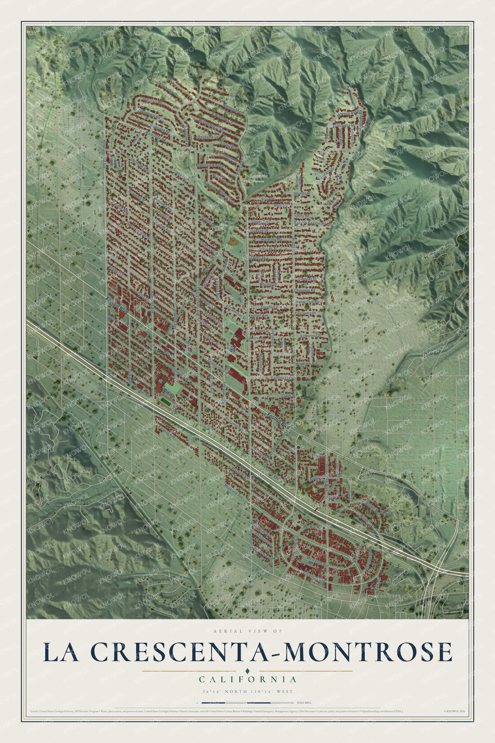
La Crescenta-Montrose, California Map Art
Building by building, with labeled streets and shaded relief.
12" x 18" Archival Matte Print
A Map of Home. A Work of Art.
Explore La Crescenta-Montrose, California from a whole new perspective. Created using aerial imagery and detailed geographic data, this map captures La Crescenta-Montrose building by building, with labeled streets, familiar landmarks, and shaded topographical relief that highlights the natural contours of the landscape.
Combining modern data with the timeless character of a vintage atlas, this map is just as interesting up close as it is beautiful on the wall. Whether you grew up in La Crescenta-Montrose, spent memorable years there, or call it home today, this unique map is a great way to celebrate a place that means something to you. Zoom in on the preview to look for your street, and then order a print to put your memories on the wall.
Three ways to hang it

Unframed archival matte, a black wood frame or a white wood frame.
Up close
Geography Worth Displaying
This map was created using accurate cartographic data and authoritative geographic sources, including the U.S. Geological Survey and the Census Bureau. The map brings together terrain, waterways, roads, and building detail. The majority of the streets are labeled, houses are accurately depicted, and the topography is derived from government sources. Combining local data with carefully composed color and shading leads to this beautifully detailed La Crescenta-Montrose artwork for your wall.
Rather than simply showing street outlines, we’ve included as many of the street names as we could reasonably fit on the map while keeping their names legible. Zoom in on the high resolution preview to see exactly what’s on the map. We truly set out to create a statement piece for anyone who loves La Crescenta-Montrose. So whether it’s for you, or a gift for someone you love, we hope this map of La Crescenta-Montrose brings back fond memories.
Read the story behind this map of La Crescenta-Montrose, California from 2026.

Find your street
Names on the La Crescenta-Montrose map
Every name below is printed on this map. Look for your street, your school, the park where you played, or the pond down the road.
Places and landmarks4
- Montrose
- Briggs Terrace
- La Crescenta
- Rosemont Preserve
Streets and roads125
- Foothill Boulevard
- Rosemont Avenue
- Briggs Avenue
- Pennsylvania Avenue
- Pineglen Road
- Pine Cone Road
- Ridgepine Drive
- Markridge Road
- Waltonia Drive
- Florencita Avenue
- Montrose Avenue
- Cloud Avenue
- Raymond Avenue
- Ramsdell Avenue
- La Crescenta Avenue
- Orange Avenue
- Glenwood Avenue
- Altura Avenue
- Prospect Avenue
- El Caminito Street
- Community Avenue
- Los Olivos Lane
- Fairmount Avenue
- Mayfield Avenue
- Henrietta Avenue
- Canyonside Road
- Alabama Street
- Stevens Street
- Harmony Place
- Mary Street
Show all 125 streets
- Ocean View Boulevard
- Sunset Avenue
- Frances Avenue
- Paraiso Way
- Fairway Avenue
- Shields Street
- Pinelawn Drive
- Evelyn Street
- Dyer Street
- Janet Lee Drive
- Santa Carlotta Street
- Teasley Street
- Cloudcrest Road
- Del Mar Road
- Willow Haven Drive
- Mountain Pine Drive
- Highridge Road
- Rockdell Street
- Gertrude Avenue
- Sanborn Avenue
- Mira Vista Avenue
- Crescent Avenue
- Pineridge Drive
- Encinal Avenue
- Brookhill Street
- Franklin Street
- Adams Street
- Hopeton Road
- El Moreno Street
- Terrace Drive
- Mountain Avenue
- Luana Lane
- Upper Terrace
- Laughlin Avenue
- Whittier Drive
- Frances Street
- Sharon Avenue
- Cross Street
- Olive Avenue
- Pontiac Street
- Pickens Canyon Road
- Orangedale Avenue
- Maurice Avenue
- Alta Terrace
- Rockpine Lane
- Hawkridge Drive
- Kemper Avenue
- Brierhaven Drive
- Manzanita Street
- Vicwood Avenue
- Manhattan Avenue
- Marellen Place
- Cecilville Avenue
- Glenada Avenue
- Panorama Drive
- Hermosa Avenue
- Fairesta Street
- Chapman Road
- Caracas Street
- Irving Avenue
- Rincon Avenue
- Park Place
- Young Drive
- Utley Road
- Park Avenue
- Freeman Avenue
- Los Amigos Street
- Barton Lane
- Timberlake Drive
- El Sereno Avenue
- Jayma Lane
- Piedmont Avenue
- Orange Cove Avenue
- Janvier Way
- Goss Canyon Avenue
- Countryside Lane
- Edmund Avenue
- Brookhill Avenue
- Circle Vista Avenue
- El Adobe Lane
- Cortolane Drive
- Seapine Lane
- Abella Street
- Thelma Street
- Carol Park Place
- Daver Avenue
- Hamer Court
- Humphrey Way
- Rockland Place
- Parham Avenue
- Organ Lane
- Vista del Arroyo Drive
- Dorothy Street
- Parkhaven Circle
- Laddie Lane
Names are listed as they appear on the printed map. Zoom into the product photos to find them.
About La Crescenta-Montrose, California
La Crescenta-Montrose is an unincorporated community of 19,997 people in Los Angeles County, between Glendale, La Cañada Flintridge and the Angeles National Forest. This was Tongva land, and in 1843 Governor Manuel Micheltorena made it part of Rancho La Cañada, a grant to Ygnacio Coronel, a schoolteacher from Pueblo de Los Ángeles. Colonel Theodore Pickens arrived in 1871 and claimed a homestead at the head of the canyon that now bears his name.
The name La Crescenta came from settler Benjamin B. Briggs, who saw three crescent shapes in the land from his home and made up a word for them. It isn't Spanish for "the crescent," which would be el creciente, but the Post Office accepted it in 1888. Montrose got its name through a contest for a new subdivision, laid out in 1913 on part of the La Crescenta tract.
- The New Year's flood of 1934Wildfires burned the San Gabriel Mountains above the valley in November 1933, and late December storms dropped 12 inches of rain on the bare slopes. Around midnight on New Year's Eve, hillsides collapsed, sending mud and boulders into the neighborhoods. More than 400 homes were lost, and 12 people died when American Legion Post 288 in Montrose, where they had sheltered, was destroyed. The Army Corps of Engineers and the county then built catch basins and concrete storm drains.
- A church of valley stoneThe artist Seymour Thomas designed and built St. Luke's of the Mountains Episcopal Church on Foothill Boulevard in 1924. He used natural stone gathered in the valley, and the church is seen as the valley's finest building.
- Rockhaven, opened in 1923Agnes Richards founded Rockhaven Sanitarium on Honolulu Avenue, a stone refuge for women with mental illness, and ran it from 1923 to 1967. Known as the "Screen Actors' Sanitarium," it cared for Billie Burke and for Gladys Baker, mother of Marilyn Monroe. It closed in 2006, and the City of Glendale bought the property in 2008.
- The school bell of 1890La Crescenta Elementary began in 1887 at Foothill and Dyer, then moved to La Crescenta and Prospect, where a wooden schoolhouse went up in 1890. Its bell called children to class from all over the valley. Newer buildings followed in 1914 and 1948. That year the bell was packed away, and in 1976 it was hung again with a plaque naming the first class.
- Le Mesnager Barn, 1911George Le Mesnager, a French patriot, built a stone barn high above the valley to store and process grapes from his Sparr Heights vineyards. The grapes went to his Old Hermitage Vineyards winery in downtown Los Angeles. The barn now belongs to Glendale and serves as a nature and history center in Deukmejian Wilderness Park.
Keep exploring California
La Crescenta-Montrose is one of 1,990 California towns we've mapped. Every dot on the map is a print of its own.
The search covers every state, California first.
Near La Crescenta-Montrose
Order 2 or more town maps and save 10%. Shown in the size and finish you picked above, so they hang as a set.
- La Cañada Flintridge 12" x 18" / Archival Matte Print $39.99
- Glendale 12" x 18" / Archival Matte Print $39.99
- Burbank 12" x 18" / Archival Matte Print $39.99


More maps nearby: Altadena, Eagle Rock, Pasadena, Bungalow Heaven and Glassell Park.
The art of mapping a place
How This Map Was Made
Real places. Remarkable detail. Discover the layers that turn geographic data into a map of home.

The view from above
Aerial imagery reveals the character of the land: woodland, open fields, and the patterns of a place.

The shape of the land
Elevation data brings hills, valleys, and subtle changes in the landscape into view.

The details of home
Roads, waterways, and building footprints come together to make the map feel unmistakably local.

Geography becomes art
Considered color, shading, and typography bring the layers together in a map made for your wall.


Process illustrated with Mendon, Massachusetts. Aerial imagery: USDA NAIP. Terrain: USGS 3D Elevation Program. Map details and finished artwork: KNOWOL.
The Details
About This Print
Choose an archival matte print, or a black or white Ayous wood frame. The archival matte print is unframed.
Select your size and finish above to see the matching product image and price.
Materials & Craftsmanship
A contemporary map with the character of a classic atlas, printed on archival matte paper. Optional frames are made from Ayous wood.
Your printed map does not include the watermark shown in the full-map preview.
Shipping & Delivery
Free shipping within the United States. Every print is made to order in the USA.
Buying a gift? Add a note in your cart and we'll include it. We never put prices in the package.
Prints ship within 2 to 3 business days. Allow 7 to 10 days total from ordering for delivery. Timing may vary during holidays or periods of high order volume.
Read our shipping policy.
Returns and damaged prints
Each print is made to order. Change-of-mind refunds are not available after production.
If your print arrives damaged, misprinted or incorrect, contact support@knowol.com within 30 days of receiving it. Include your order number, photos and a description of the issue.
Read our full refund and replacement policy. For questions about your order, email support@knowol.com.