


Search for another town


Free U.S. delivery 7 to 10 days after you order
Los Altos Hills, California Map Art
Building by building, with labeled streets and shaded relief.
12" x 18" Archival Matte Print
A Map of Home. A Work of Art.
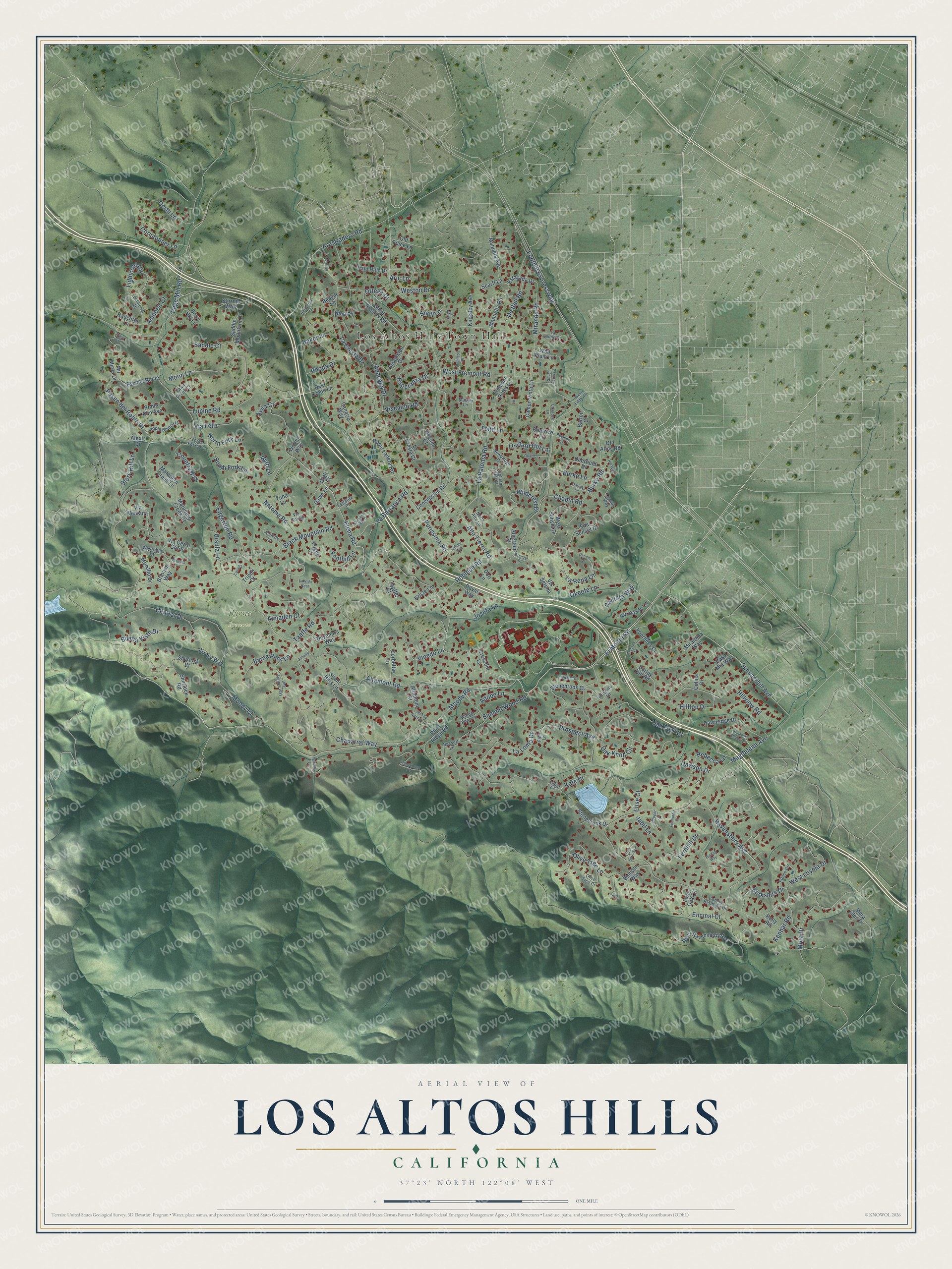
Explore Los Altos Hills, California from a whole new perspective. Created using aerial imagery and detailed geographic data, this map captures Los Altos Hills building by building, with labeled streets, familiar landmarks, and shaded topographical relief that highlights the natural contours of the landscape.
Combining modern data with the timeless character of a vintage atlas, this map is just as interesting up close as it is beautiful on the wall. Whether you grew up in Los Altos Hills, spent memorable years there, or call it home today, this unique map is a great way to celebrate a place that means something to you. Zoom in on the preview to look for your street, and then order a print to put your memories on the wall.
Three ways to hang it

Unframed archival matte, a black wood frame or a white wood frame.
Up close
Geography Worth Displaying
This map was created using accurate cartographic data and authoritative geographic sources, including the U.S. Geological Survey and the Census Bureau. The map brings together terrain, waterways, roads, and building detail. The majority of the streets are labeled, houses are accurately depicted, and the topography is derived from government sources. Combining local data with carefully composed color and shading leads to this beautifully detailed Los Altos Hills artwork for your wall.
Rather than simply showing street outlines, we’ve included as many of the street names as we could reasonably fit on the map while keeping their names legible. Zoom in on the high resolution preview to see exactly what’s on the map. We truly set out to create a statement piece for anyone who loves Los Altos Hills. So whether it’s for you, or a gift for someone you love, we hope this map of Los Altos Hills brings back fond memories.
Read the story behind this map of Los Altos Hills, California from 2026.

Find your street
Names on the Los Altos Hills map
Every name below is printed on this map. Look for your street, your school, the park where you played, or the pond down the road.
Places and landmarks2
- Los Altos Hills Town Hall
- Byrne Preserve
Streets and roads214
- El Monte Road
- Paseo del Roble Drive
- Moody Road
- Summerhill Avenue
- Elena Road
- Prospect Avenue
- Page Mill Road
- West Fremont Road
- Altamont Road
- Magdalena Avenue
- Arastradero Road
- Purissima Road
- Robleda Road
- La Cresta Drive
- Natoma Road
- Ravensbury Avenue
- La Paloma Road
- Hilltop Drive
- Central Drive
- West Loyola Drive
- Chaparral Way
- Taaffe Road
- Okeefe Lane
- La Loma Drive
- Summit Wood Road
- Black Mountain Road
- Foothill Expressway
- Viscaino Road
- Olive Tree Lane
- Anacapa Drive
Show all 214 streets
- Burke Road
- Oak Knoll Circle
- Oak Park Court
- Miranda Road
- Esperanza Drive
- Dawson Drive
- Liddicoat Circle
- Kate Drive
- Mora Drive
- Wildcrest Drive
- Moody Court
- La Barranca Road
- Almaden Court
- Christopher Lane
- Story Hill Lane
- Byrne Park Lane
- Lupine Road
- Edgerton Road
- Moon Lane
- Berkshire Drive
- Hillview Road
- Fernhill Drive
- De Bell Road
- Via Feliz
- Buena Vista Drive
- Country Way
- Alta Tierra Road
- South Fork Lane
- Josefa Lane
- Gerth Lane
- Vinedo Lane
- Burke Lane
- Byrd Lane
- Rebecca Lane
- North Fork Lane
- Chapin Road
- Orchard Hill Lane
- Ursula Lane
- Saddle Court
- Adobe Lane
- Encinal Court
- Aric Lane
- Snell Lane
- Rhoda Drive
- Amherst Court
- Weston Drive
- Cantata Way
- Foothill Lane
- La Rena Lane
- Kenbar Road
- Baker Lane
- Todd Lane
- Ortega Drive
- Jabil Lane
- Elise Court
- Avila Court
- Stonebrook Drive
- Concepcion Road
- Manuella Road
- Sherlock Road
- Pso del Roble
- Rhus Ridge Road
- Saint Francis Road
- Saddle Mountain Drive
- East Sunset Drive
- Matadero Creek Lane
- Ascension Drive
- Via Ventana
- West Ravensbury Avenue
- West Sunset Drive
- Dawnridge Drive
- Stonebrook Court
- Roble Ladera Road
- Dezahara Way
- Briones Way
- Barley Hill Road
- Voorhees Drive
- Mir Mirou Drive
- Duval Way
- Miraloma Way
- Normandy Lane
- Fremont Pines Lane
- Campo Vista Lane
- Manuela Avenue
- Lone Oak Lane
- Viscaino Court
- Wright Way
- La Cresta Court
- Berry Hill Lane
- Kingsley Avenue
- Corbetta Lane
- Roble Alto Avenue
- Estacada Drive
- Nina Place
- Deerfield Drive
- Arroyo Way
- Canario Way
- Palo Hills Drive
- Blandor Way
- Wild Plum Lane
- Matadero Creek Court
- Yuba Lane
- Stirrup Way
- Atherton Court
- Casa Mia Way
- Scarff Lane
- Menalto Drive
- Beaver Lane
- Radcliffe Lane
- Vogue Court
- Altamont Court
- Old Trace Lane
- Crescent Lane
- Via Cerro Gordo
- Vis Serena
- Dawn Lane
- Beatrice Lane
- Kriste Lane
- Sherlock Court
- Deer Creek Lane
- Old Altos Road
- Gigli Court
- Taaffe Court
- Dori Lane
- Rolly Road
- Alexis Drive
- Mora Glen Drive
- Silent Hills Lane
- Tripoli Court
- Barton Court
- Colina Drive
- Camino Hermoso Drive
- Priscilla Lane
- Eloise Circle
- Liddicoat Drive
- Roble Blanco Court
- Olive Tree Court
- Golden Hill Court
- Willow Pond Lane
- Newbridge Drive
- Melody Lane
- Laura Court
- Bassett Lane
- La Lanne Court
- Lennox Way
- Three Forks Lane
- Fawn Creek Court
- Westridge Court
- North Alta Lane
- Via Corita
- Estralita Place
- Maurer Lane
- Finn Lane
- Francemont Drive
- Horseshoe Lane
- Dianne Drive
- Deer Springs Way
- Clausen Court
- Oneonta Drive
- Murietta Lane
- Cumbra Vista Court
- Quail Lane
- Princess Ellena Court
- Moody Springs Court
- Donelson Place
- Robleda Court
- Hooper Lane
- Cold Spring Lane
- La Vida Real
- Snell Court
- Cicerone Lane
- Darling Lane
- Cortez Lane
- Frampton Court
- Tracy Court
- Cll del Sol
- West Edith Avenue
- Briones Court
- Seven Acres Lane
- Brendel Drive
- Julietta Lane
- Carillo Lane
- Hill Way
- Winton Way
Names are listed as they appear on the printed map. Zoom into the product photos to find them.
About Los Altos Hills, California
From the National Park Service: "Construction of the Percy Morgan estate, originally known as Lantarnam Hall and now known as the Ford County Day School, began in 1914 and was completed two years later."
Keep exploring California
Los Altos Hills is one of 1,990 California towns we've mapped. Every dot on the map is a print of its own.
The search covers every state, California first.
Near Los Altos Hills
Order 2 or more town maps and save 10%. Shown in the size and finish you picked above, so they hang as a set.
- Palo Alto 12" x 18" / Archival Matte Print $39.99
- Los Altos 12" x 18" / Archival Matte Print $39.99
- Loyola 12" x 18" / Archival Matte Print $39.99


More maps nearby: College_Terrace, Mountain View, Ladera, Stanford and Portola Valley.
The art of mapping a place
How This Map Was Made
Real places. Remarkable detail. Discover the layers that turn geographic data into a map of home.

The view from above
Aerial imagery reveals the character of the land: woodland, open fields, and the patterns of a place.

The shape of the land
Elevation data brings hills, valleys, and subtle changes in the landscape into view.

The details of home
Roads, waterways, and building footprints come together to make the map feel unmistakably local.

Geography becomes art
Considered color, shading, and typography bring the layers together in a map made for your wall.


Process illustrated with Mendon, Massachusetts. Aerial imagery: USDA NAIP. Terrain: USGS 3D Elevation Program. Map details and finished artwork: KNOWOL.
The Details
About This Print
Choose an archival matte print, or a black or white Ayous wood frame. The archival matte print is unframed.
Select your size and finish above to see the matching product image and price.
Materials & Craftsmanship
A contemporary map with the character of a classic atlas, printed on archival matte paper. Optional frames are made from Ayous wood.
Your printed map does not include the watermark shown in the full-map preview.
Shipping & Delivery
Free shipping within the United States. Every print is made to order in the USA.
Buying a gift? Add a note in your cart and we'll include it. We never put prices in the package.
Prints ship within 2 to 3 business days. Allow 7 to 10 days total from ordering for delivery. Timing may vary during holidays or periods of high order volume.
Read our shipping policy.
Returns and damaged prints
Each print is made to order. Change-of-mind refunds are not available after production.
If your print arrives damaged, misprinted or incorrect, contact support@knowol.com within 30 days of receiving it. Include your order number, photos and a description of the issue.
Read our full refund and replacement policy. For questions about your order, email support@knowol.com.