
Search for another town





Free U.S. delivery 7 to 10 days after you order
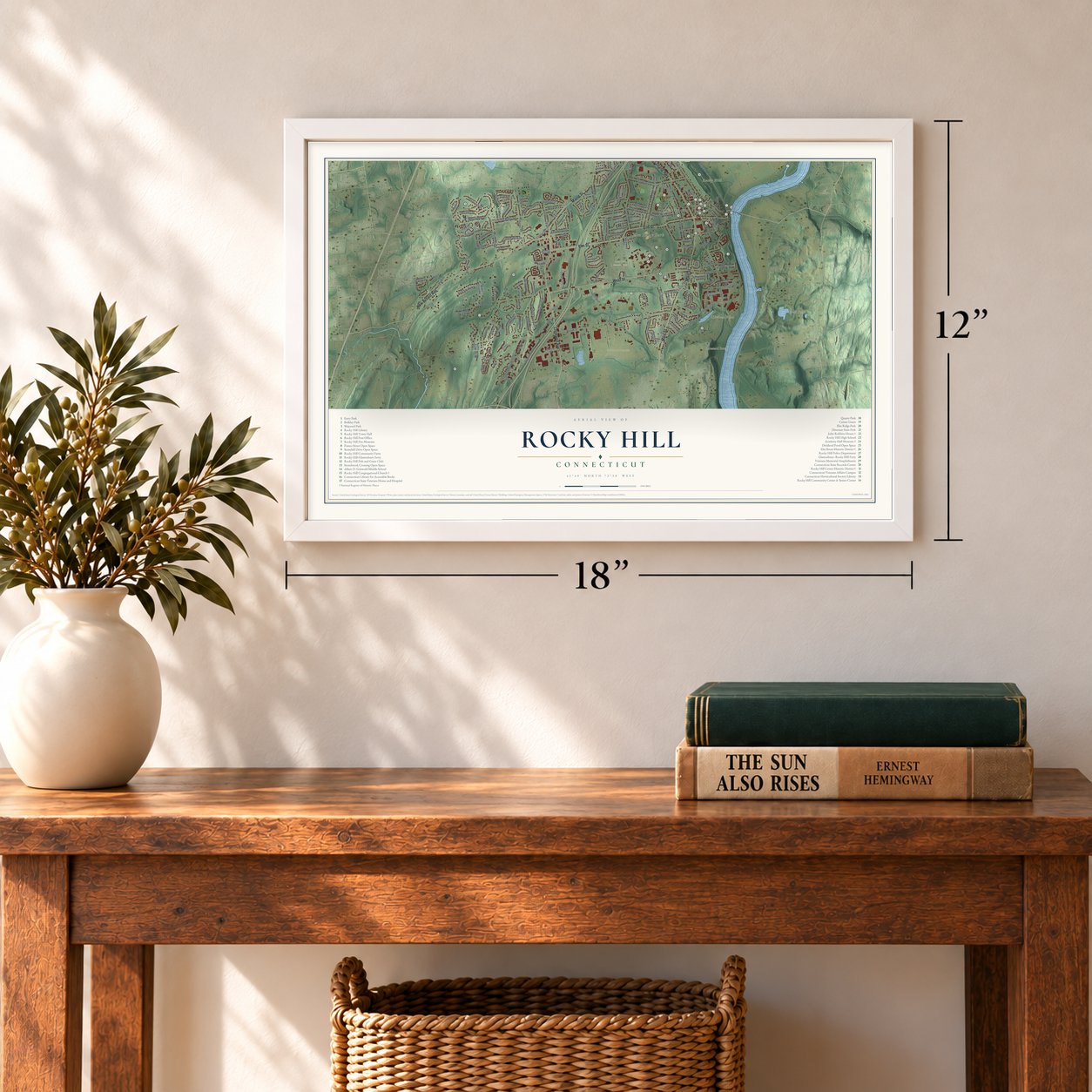
Rocky Hill, Connecticut Map Art
Building by building, with labeled streets and shaded relief.
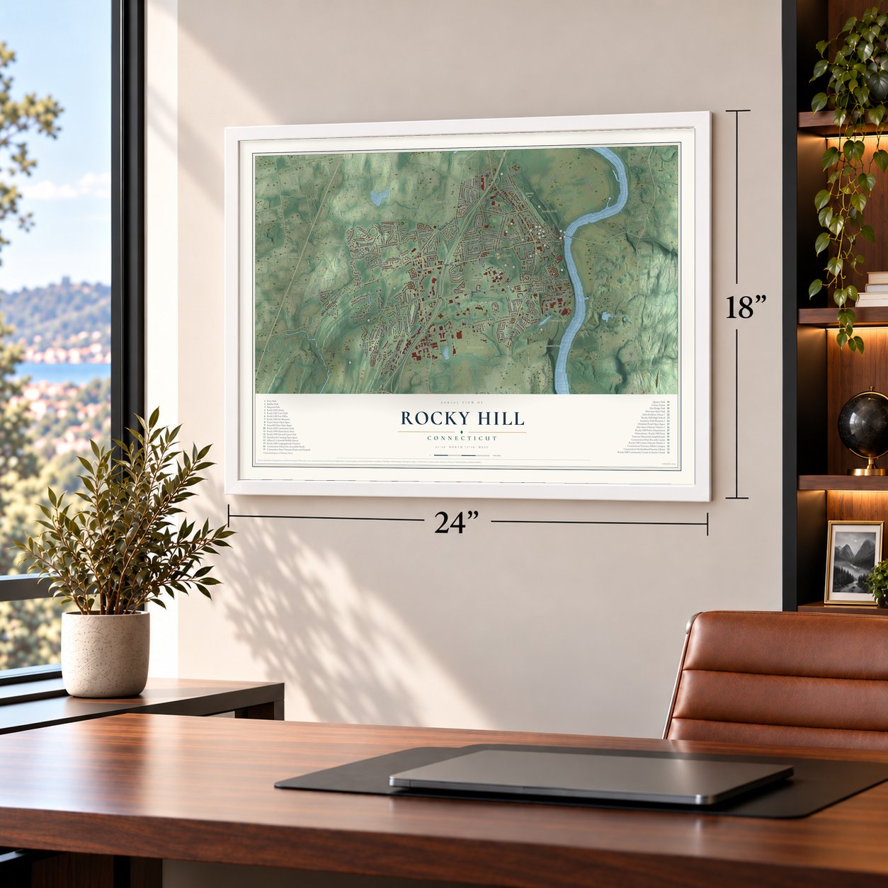
12" x 18" Archival Matte Print
A Map of Home. A Work of Art.
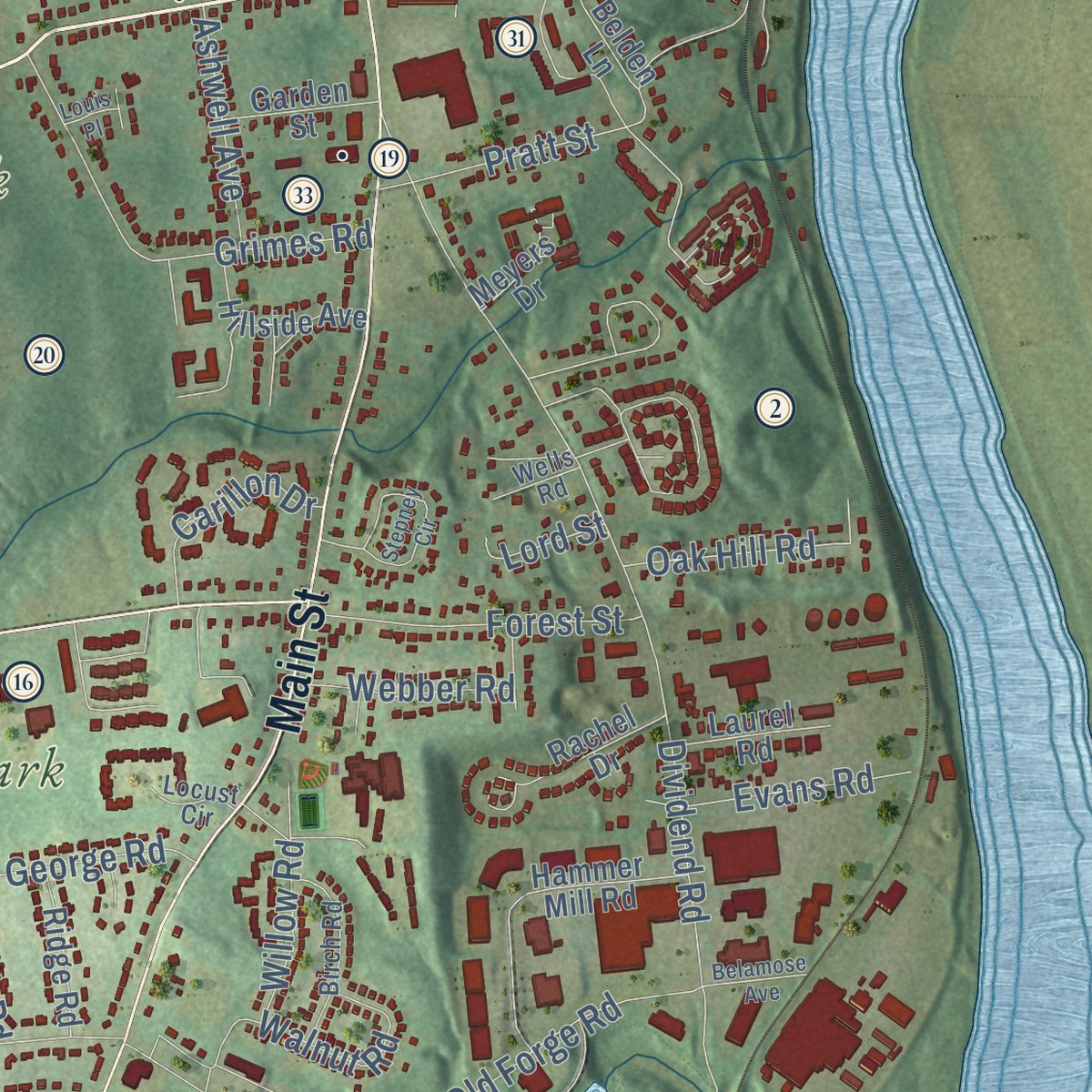
Explore Rocky Hill, Connecticut from a whole new perspective. Created using aerial imagery and detailed geographic data, this map captures Rocky Hill building by building, with labeled streets, familiar landmarks, and shaded topographical relief that highlights the natural contours of the landscape.
Combining modern data with the timeless character of a vintage atlas, this map is just as interesting up close as it is beautiful on the wall. Whether you grew up in Rocky Hill, spent memorable years there, or call it home today, this unique map is a great way to celebrate a place that means something to you. Zoom in on the preview to look for your street, and then order a print to put your memories on the wall.

Three ways to hang it
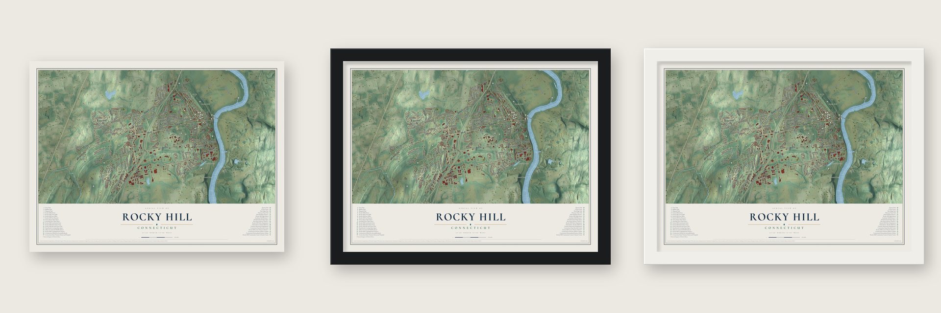
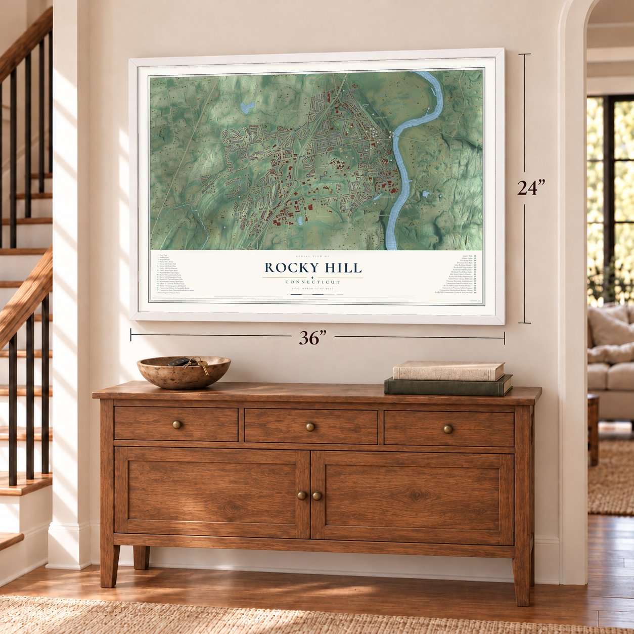
Unframed archival matte, a black wood frame or a white wood frame.
Up close
Geography Worth Displaying
This map was created using accurate cartographic data and authoritative geographic sources, including the U.S. Geological Survey (USGS) and FEMA. The map brings together terrain, waterways, roads, and building detail. The majority of the streets are labeled, houses are accurately depicted, and the topography is derived from government sources. Combining local data with carefully composed color and shading leads to this beautifully detailed Rocky Hill artwork for your wall.
Rather than simply showing street outlines, we’ve included as many of the street names as we could reasonably fit on the map while keeping their names legible. Zoom in on the high resolution preview to see exactly what’s on the map. We truly set out to create a statement piece for anyone who loves Rocky Hill. So whether it’s for you, or a gift for someone you love, we hope this map of Rocky Hill brings back fond memories.
Explore the full map of Rocky Hill, Connecticut and read about the local places it shows.

Find your street
Names on the Rocky Hill map
Every name below is printed on this map. Look for your street, your school, the park where you played, or the pond down the road.
Places and landmarks13
- Downtown
- Hang-Dog Hill
- Mustard Bowl
- Rocky Hill
- Vexation Hill
- Dividend Pond
- Great Pond
- Dinosaur State Park
- Maxwell Park
- Elm Ridge Park
- Gardner's Nurseries
- Quarry Park
Show all 13 places
- Rose Hill Memorial Park
Streets and roads174
- Elm Street
- Cromwell Avenue
- New Britain Avenue
- Main Street
- West Street
- Silas Deane Highway
- Maple Street
- Candle Lite Drive
- Great Meadow Road
- Capitol Boulevard
- France Street
- Brook Street
- Dividend Road
- Old Main Street
- Meadow Road
- Gilbert Avenue
- Century Hills Drive
- Orchard Street
- Whitewood Drive
- North Meadow Lane
- Parsonage Street
- Pleasant Valley Road
- Hayes Road
- Cold Spring Road
- Old Forge Road
- Robinson Road
- Trinity Ridge
- Mountain View Drive
- Bailey Road
- Pheasant Drive
Show all 174 streets
- Silo Drive
- New Road
- Chapin Avenue
- Pratt Street
- Stone Hill Drive
- Grimes Road
- Maxwell Drive
- Corporate Place
- Ridgewood Drive
- Sunset Ridge
- Ten Rod Highway
- Raymond Road
- Wynding Brook Drive
- Westmeadow Road
- Bayberry Lane
- Fern Street
- North Condor Drive
- Highland Street
- Murphy Drive
- Forest Street
- Falcon Ridge Road
- Country Side Drive
- Cobey Road
- Boulder Drive
- Terry Lane
- Marshall Road
- Westbrook Road
- Waters Avenue
- Fox Hill Drive
- Richard Road
- Hunters Ridge
- Textbook Avenue
- Barry Place
- Evans Road
- Sky View Drive
- Courtney Drive
- Wright Road
- Walnut Road
- Peria Drive
- Butternut Lane
- Ashwell Avenue
- Carillon Drive
- Fernwood Drive
- Summer Lane
- George Road
- June Circle
- Charter Road
- Oak Hill Road
- Webber Road
- Henkel Way
- Beecher Lane
- Cronin Drive
- Willow Road
- Sutton Road
- Quail Drive
- Starr Drive
- Knoll Lane
- Haren Drive
- Sandy Drive
- Park Drive
- Lord Street
- Westerly Terrace
- Woodfield Crossing
- Catherine Drive
- Speno Ridge
- Riverview Road
- Hammer Mill Road
- Farms Village Road
- Bucks Crossing
- Lavender Lane
- Valley Brook Road
- Windy Hill Lane
- Rachel Drive
- Robbins Lane
- Sawmill Road
- Inwood Road
- Gaylord Drive
- Tumble Brook Road
- Elm Ridge Drive
- Deming Road
- Hillside Avenue
- Joiners Road
- Tedwin Farms Road
- Barnyard Road
- Toll Gate Road
- Town Line Road
- Goff Brook Lane
- Ridge Road
- Knollwood Road
- Old Tannery Lane
- Krol Farm Road
- Garden Street
- Parish Road
- Rocamora Road
- Little Oak Lane
- Farmstead Road
- Laurel Road
- Autumn Circle
- Belden Lane
- Garfield Road
- Rhodes Road
- Meyers Drive
- Annes Court
- Concord Drive
- Penn Place
- Deer Path
- Hawthorne Circle
- Briarwood Court
- Rosewood Drive
- Birch Road
- Valley View Drive
- Clearview Avenue
- Carol Drive
- Hollister Drive
- Gray Fox Lane
- Winter Lane
- Corncrib Lane
- Esther Drive
- Sunny Crest Drive
- Hidden Valley Drive
- Deerfield Run
- Valley Crest Drive
- Country Club Court
- Griswold Road
- Locust Circle
- Wells Road
- Huskie Drive
- Belaire Circle
- Elm Street Extended
- Copper Beech Drive
- Dogwood Court
- Partridge Drive
- Stepney Circle
- Washington Street
- Berkshire Road
- West Ridge Drive
- Ramblewood Drive
- Cambridge Drive
- Allison Way
- Maryanna Way
- Belamose Avenue
- Jason Drive
- The Mews
- Louis Place
Names are listed as they appear on the printed map. Zoom into the product photos to find them.
About Rocky Hill, Connecticut
Rocky Hill is a town of 20,845 people in Hartford County, with the Connecticut River on its eastern side. The Wangunk people held this land before settlers from Wethersfield began claiming it in 1650. When the south end of Wethersfield formed its own parish in 1722, the first choice of name was Lexington, for the Massachusetts home of Joseph Grimes. Grimes objected that two Lexingtons were one too many, so the parish was called Stepney instead.
People kept naming the place for the rocky ridge above the river landing anyway. In 1796 Timothy Dwight, president of Yale, wrote that hardly anyone in the state had heard the name Stepney. The legislature settled the matter in 1826 by adopting Rocky Hill as the official name. A 1906 history complained that the name pleased neither ear, eye nor imagination, but it stuck, and in 1843 Rocky Hill became a town of its own.
“On the Northern side of this hill is a magnificent view over the Connecticut Valley, about 50 miles in length and 20 in breadth.”
- A river crossing since 1655A ferry began carrying people across the Connecticut to what is now Glastonbury in 1655, before either town existed. It started as a raft pushed along with poles, was later driven by a horse walking a treadmill, and got a steamboat in 1876. It is believed to be the oldest ferry in the country that has run without a break, and today the towboat Cumberland pulls the three-car barge Hollister III across from April through November.
- Sloops and privateersIn December 1672 Wethersfield set aside five riverside acres for a public landing and shipyard, and after a 1700 flood shifted the river, it became Wethersfield's main port. In 1776 Congress commissioned the yard's Revenge, Silas Deane's sloop, with eight guns and 64 men. The Dolphin sailed as a privateer in 1777 with ten guns.
- Shad at Uncle Sammy'sSamuel Shipman, a farmer born in town, bought the Rocky Hill Hotel on the Middletown turnpike in 1837 and gave it his name. Known as Uncle Sammy, he offered nine-pin bowling and a dance hall, and Hartford parties drove down in summer and came by sleigh in winter. Samuel Colt brought foreign officers touring his arms works down the river on his steam yacht Dauntless for Mrs. Shipman's Connecticut River shad. The hotel closed after Shipman died about 1875.
- Tracks under a bulldozerIn 1966 a bulldozer operator clearing ground for a new state office building uncovered dinosaur tracks in the sandstone. The state opened Dinosaur State Park on the site in 1968. About 500 tracks, roughly 200 million years old, lie under a geodesic dome, and 1,500 more were left buried to protect them.
- A brick school from 1803Abraham Jaggars built the brick academy on Old Main Street in 1803. Fire gutted the private academy in 1839, and it served afterward as a public school until 1941. In 1965 the Rocky Hill Historical Society, after restoring the building, opened Academy Hall as its museum.
Keep exploring Connecticut
Rocky Hill is one of 382 Connecticut towns we've mapped. Every dot on the map is a print of its own.
The search covers every state, Connecticut first.
Near Rocky Hill
Order 2 or more town maps and save 10%. Shown in the size and finish you picked above, so they hang as a set.
- Cromwell 12" x 18" / Archival Matte Print $39.99
- Wethersfield 12" x 18" / Archival Matte Print $39.99
- Hopewell 12" x 18" / Archival Matte Print $39.99


More maps nearby: Newington, Glastonbury Center, Portland, Kensington and Glastonbury.
The art of mapping a place
How This Map Was Made
Real places. Remarkable detail. Discover the layers that turn geographic data into a map of home.

The view from above
Aerial imagery reveals the character of the land: woodland, open fields, and the patterns of a place.

The shape of the land
Elevation data brings hills, valleys, and subtle changes in the landscape into view.

The details of home
Roads, waterways, and building footprints come together to make the map feel unmistakably local.

Geography becomes art
Considered color, shading, and typography bring the layers together in a map made for your wall.


Process illustrated with Mendon, Massachusetts. Aerial imagery: USDA NAIP. Terrain: USGS 3D Elevation Program. Map details and finished artwork: KNOWOL.
The Details
About This Print
Choose an archival matte print, or a black or white Ayous wood frame. The archival matte print is unframed.
Select your size and finish above to see the matching product image and price.
Materials & Craftsmanship
A contemporary map with the character of a classic atlas, printed on archival matte paper. Optional frames are made from Ayous wood.
Your printed map does not include the watermark shown in the full-map preview.
Shipping & Delivery
Free shipping within the United States. Every print is made to order in the USA.
Buying a gift? Add a note in your cart and we'll include it. We never put prices in the package.
Prints ship within 2 to 3 business days. Allow 7 to 10 days total from ordering for delivery. Timing may vary during holidays or periods of high order volume.
Read our shipping policy.
Returns and damaged prints
Each print is made to order. Change-of-mind refunds are not available after production.
If your print arrives damaged, misprinted or incorrect, contact support@knowol.com within 30 days of receiving it. Include your order number, photos and a description of the issue.
Read our full refund and replacement policy. For questions about your order, email support@knowol.com.