
Search for another town


Free U.S. delivery 7 to 10 days after you order
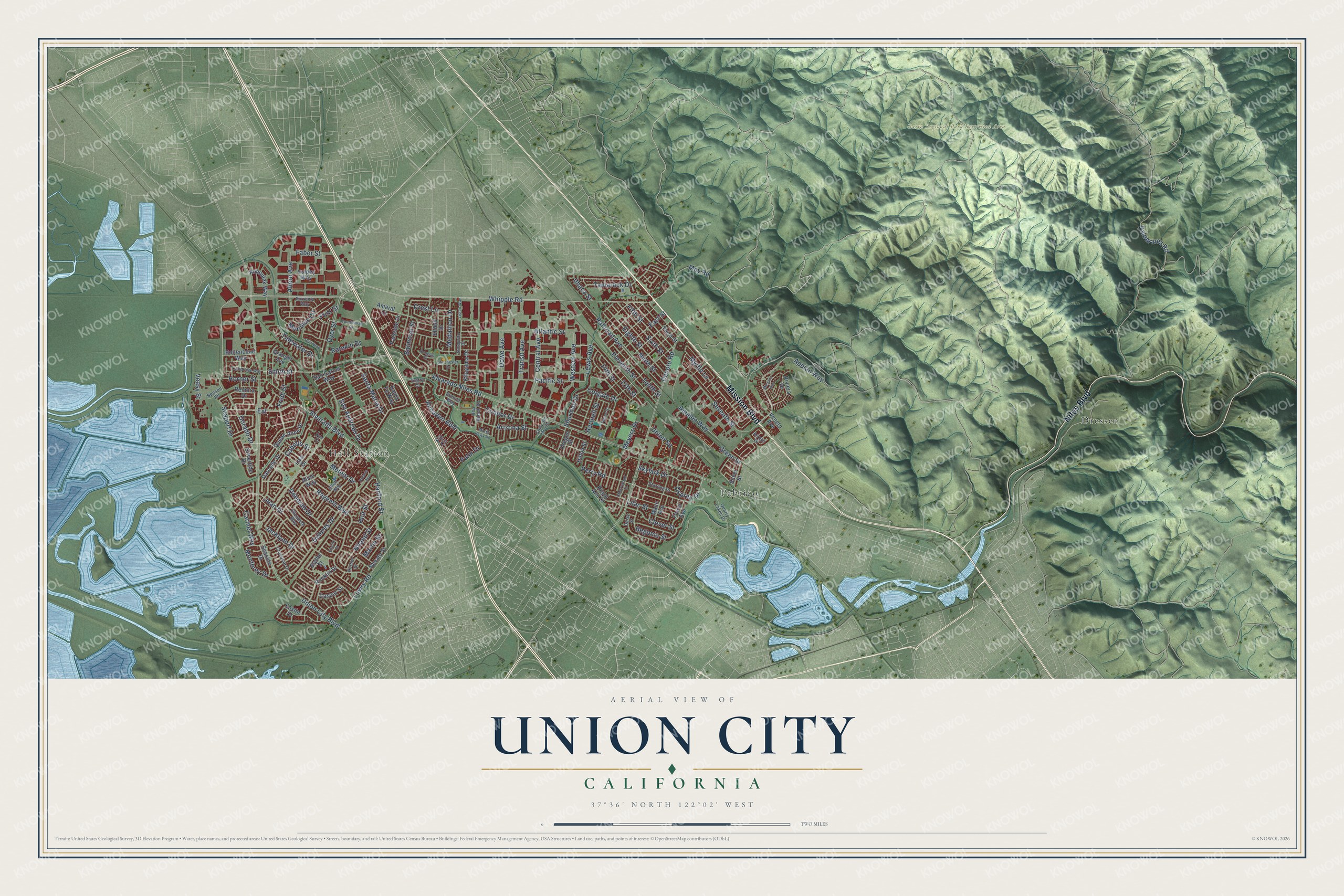
Union City, California Map Art
Building by building, with labeled streets and shaded relief.
12" x 18" Archival Matte Print
A Map of Home. A Work of Art.
Explore Union City, California from a whole new perspective. Created using aerial imagery and detailed geographic data, this map captures Union City building by building, with labeled streets, familiar landmarks, and shaded topographical relief that highlights the natural contours of the landscape.
Combining modern data with the timeless character of a vintage atlas, this map is just as interesting up close as it is beautiful on the wall. Whether you grew up in Union City, spent memorable years there, or call it home today, this unique map is a great way to celebrate a place that means something to you. Zoom in on the preview to look for your street, and then order a print to put your memories on the wall.
Three ways to hang it

Unframed archival matte, a black wood frame or a white wood frame.
Up close
Geography Worth Displaying
This map was created using accurate cartographic data and authoritative geographic sources, including the U.S. Geological Survey and the Census Bureau. The map brings together terrain, waterways, roads, and building detail. The majority of the streets are labeled, houses are accurately depicted, and the topography is derived from government sources. Combining local data with carefully composed color and shading leads to this beautifully detailed Union City artwork for your wall.
Rather than simply showing street outlines, we’ve included as many of the street names as we could reasonably fit on the map while keeping their names legible. Zoom in on the high resolution preview to see exactly what’s on the map. We truly set out to create a statement piece for anyone who loves Union City. So whether it’s for you, or a gift for someone you love, we hope this map of Union City brings back fond memories.
Read the story behind this map of Union City, California from 2026.

Find your street
Names on the Union City map
Every name below is printed on this map. Look for your street, your school, the park where you played, or the pond down the road.
Places and landmarks4
- Garin Regional Park Restricted Area
- Hall Station
- Dresser
- Pabrico
Streets and roads141
- Mission Boulevard
- Niles Boulevard
- Whipple Road
- Alvarado Boulevard
- Regents Boulevard
- Hanford Street
- Dorado Drive
- Extension
- Tidewater Drive
- Niland Street
- Jean Drive
- Central Avenue
- Perry Road
- Seaport Drive
- Alvarado Niles Road
- Union City Boulevard
- Dyer Street
- Decoto Road
- San Andreas Drive
- Appian Way
- Seventh Street
- Lowry Road
- Palomares Road
- Almaden Boulevard
- Eleventh Street
- Cabello Street
- Palm Drive
- Santa Maria Drive
- Smith Street
- Delores Drive
Show all 141 streets
- Arizona Street
- Medallion Drive
- Dowe Avenue
- Railroad Avenue
- Horner Street
- Tamarack Drive
- Western Avenue
- Meridien Circle
- Amaleo Way
- Ninth Street
- Eighth Street
- Pacific Street
- Fredi Street
- Deborah Drive
- Carmel Way
- May Road
- Colgate Drive
- Sixth Street
- 13th Street
- Sherman Drive
- Begonia Street
- Clover Street
- Fifth Street
- Atlantic Street
- Tenth Street
- Ahern Avenue
- Ratekin Drive
- East Street
- Skylark Drive
- 14th Street
- Meteor Drive
- Balmoral Street
- Lewis Avenue
- Jacklynn Drive
- Condor Drive
- Osprey Drive
- Transit Avenue
- Union Square
- Crest Lane
- Meyers Drive
- Myrtle Lane
- Hartnell Street
- Green Street
- Monterey Drive
- Holt Street
- Faber Street
- Lilac Street
- Ithaca Street
- Martin Street
- Veasy Street
- Flint Street
- Queen Anne Drive
- Remora Drive
- Parkside Drive
- Royal Ann Drive
- Riviera Drive
- Rocklin Drive
- Mann Avenue
- Third Street
- Silvertide Drive
- Eastin Drive
- Granger Avenue
- Kohoutek Way
- San Carlos Way
- Kitayama Drive
- Darcelle Drive
- Bettencourt Way
- Seaside Drive
- Volpey Way
- Alice Way
- Veneto Avenue
- Farrol Avenue
- Novato Street
- Shield Drive
- Caspar Street
- Amaral Court
- Oregon Street
- Hilton Street
- Santa Fe Way
- Silver Street
- Lisa Drive
- Blythe Street
- Fiji Circle
- Daisy Street
- Ellen Way
- Quarry Lakes Drive
- Hop Ranch Road
- Copa del Oro Drive
- Christine Drive
- Sunsprite Drive
- Korbel Street
- Starling Drive
- Sorrento Way
- Elizabeth Way
- Arroyo Drive
- Benson Road
- Brenda Way
- Trefry Court
- Marsh Hawk Road
- Courthouse Drive
- Cambridge Way
- Polaris Avenue
- Winchester Drive
- Monaco Avenue
- Cherrywood Drive
- Carr Way
- Tulane Street
- Empire Street
- Liston Way
- Douglas Street
- Dyer Court
Names are listed as they appear on the printed map. Zoom into the product photos to find them.
About Union City, California
Union City is a city of 70,143 people in Alameda County. Hayward lies on its northern side, while Fremont and Newark lie on its southern side. Ohlone people were the first to live here, along the Alameda and Dry Creeks, and they buried their dead in shell mounds beside the sloughs of Alameda Creek. In 1850 the brothers John and William Horner started the first settlement of newcomers and called it Union City, after The Union, their steamship on the Sacramento River.
In 1854 Union City joined New Haven, settled in 1851, to form the town of Alvarado, named for Juan Bautista Alvarado, a former Mexican governor. Decoto grew up to the east as a railroad hub after its founding in 1870. In the 1950s Newark, Hayward and what would become Fremont all hoped to annex the two towns, so on January 13, 1959, Alvarado and Decoto joined as one city and took back the Horners' old name. Tom Kitayama became the first mayor, and the city grew from 6,000 people that year to 70,000 by 2020.
“Dyer, 'father of the American beet sugar industry,' built the factory in 1870 on a corner of his farm.”
- Alameda County's first seatAlvarado was the county seat when its courthouse opened on June 6, 1853, in a two-story wooden store that also held a post office. Henry C. Smith and A. M. Church put up that building. The seat went to San Leandro in 1865. The site was later paved over when Union City Boulevard was widened, and it is a California Historical Landmark.
- The first beet sugar millThe California Beet Sugar Company started up in Alvarado in 1870 and became the first successful sugar beet mill in the United States. The plant was torn down in 1977, and California Historical Landmark #768, at Dyer and Ratekin, marks where it stood.
- A Masonic home since 1898The Masonic Widows and Orphans Home opened in 1898 in a five-story brick building above Decoto. A north wing followed in 1914 and a south wing in 1928, and the building now anchors the Masonic Home at Union City, a 305-acre senior campus for Freemasons and their spouses. Inside, paintings of fourteen Masonic U.S. presidents hang near a staircase with stained glass windows.
- Remembering Flight 93Sugar Mill Landing Park on Dyer Street holds the Bay Area Flight 93 Memorial, the first monument finished in the country for the passengers and crew of the San Francisco-bound flight hijacked on September 11, 2001. The memorial uses 40 large granite stones, set in honor of the passengers.
Keep exploring California
Union City is one of 1,990 California towns we've mapped. Every dot on the map is a print of its own.
The search covers every state, California first.
Near Union City
Order 2 or more town maps and save 10%. Shown in the size and finish you picked above, so they hang as a set.
- Hayward 12" x 18" / Archival Matte Print $39.99
- Fairview 12" x 18" / Archival Matte Print $39.99
- Newark 12" x 18" / Archival Matte Print $39.99


More maps nearby: Cherryland, Sunol, Castro Valley, San Lorenzo and Ashland.
The art of mapping a place
How This Map Was Made
Real places. Remarkable detail. Discover the layers that turn geographic data into a map of home.

The view from above
Aerial imagery reveals the character of the land: woodland, open fields, and the patterns of a place.

The shape of the land
Elevation data brings hills, valleys, and subtle changes in the landscape into view.

The details of home
Roads, waterways, and building footprints come together to make the map feel unmistakably local.

Geography becomes art
Considered color, shading, and typography bring the layers together in a map made for your wall.


Process illustrated with Mendon, Massachusetts. Aerial imagery: USDA NAIP. Terrain: USGS 3D Elevation Program. Map details and finished artwork: KNOWOL.
The Details
About This Print
Choose an archival matte print, or a black or white Ayous wood frame. The archival matte print is unframed.
Select your size and finish above to see the matching product image and price.
Materials & Craftsmanship
A contemporary map with the character of a classic atlas, printed on archival matte paper. Optional frames are made from Ayous wood.
Your printed map does not include the watermark shown in the full-map preview.
Shipping & Delivery
Free shipping within the United States. Every print is made to order in the USA.
Buying a gift? Add a note in your cart and we'll include it. We never put prices in the package.
Prints ship within 2 to 3 business days. Allow 7 to 10 days total from ordering for delivery. Timing may vary during holidays or periods of high order volume.
Read our shipping policy.
Returns and damaged prints
Each print is made to order. Change-of-mind refunds are not available after production.
If your print arrives damaged, misprinted or incorrect, contact support@knowol.com within 30 days of receiving it. Include your order number, photos and a description of the issue.
Read our full refund and replacement policy. For questions about your order, email support@knowol.com.